
AllWeather
-
Posts
609 -
Joined
-
Last visited
Content Type
Profiles
Blogs
Forums
American Weather
Media Demo
Store
Gallery
Everything posted by AllWeather
-

December 16 2020 CTP Snowstorm Disco and Obs
AllWeather replied to pasnownut's topic in Upstate New York/Pennsylvania
Festive flurries have begun in Manheim, LancCo -
Central PA - Winter 2020/2021
AllWeather replied to MAG5035's topic in Upstate New York/Pennsylvania
He’s one of the best there is, especially for this region. My thoughts are similar to his. The warm nose will no doubt climb into SE counties...how far it goes north is the million dollar question. I’m in Manheim, but I still think I’ll flip to sleet at some point, but could also be timed with any potential dry slot. The warm nose is actually above 850, so 850/925 T maps look good, but the sleet period will be due to what’s happening between 800-700mb. Regardless, the thump is going to be thumpin’ and if the back end deform zone can get going like the RGEM shows, then even far SE zones will finish off with some fun. Either way, it’s the best shot at wintry weather we’ve had in several years, and given how much this year has sucked, I plan to soak it alllllll in. -
Central PA - Winter 2020/2021
AllWeather replied to MAG5035's topic in Upstate New York/Pennsylvania
Smells like snow. -
Central PA - Winter 2020/2021
AllWeather replied to MAG5035's topic in Upstate New York/Pennsylvania
I spent 2 nights at the TV station for that one. Finished with 32”. Our Jeep Grand Cherokee high-centered in our flat driveway. -
Central PA - Winter 2020/2021
AllWeather replied to MAG5035's topic in Upstate New York/Pennsylvania
bUt ThE rAtIoS -
Central PA - Winter 2020/2021
AllWeather replied to MAG5035's topic in Upstate New York/Pennsylvania
This will be my first winter storm in 8 years where I don’t have to worry about a “viewing area” forecast. I get to enjoy the storm IMBY with my family. -
Yupp. And does naughty things.
-
Central PA - Winter 2020/2021
AllWeather replied to MAG5035's topic in Upstate New York/Pennsylvania
00z CMC goes full over my house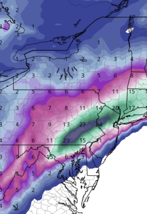
-
Central PA - Winter 2020/2021
AllWeather replied to MAG5035's topic in Upstate New York/Pennsylvania
I remember Jan 2016 was showing up STRONG in the guidance at 6-7 days out. By day 4-5, there was this kind of consistency and it just locked in from there. -
Central PA - Winter 2020/2021
AllWeather replied to MAG5035's topic in Upstate New York/Pennsylvania
For the LSV folks: The 00z GFS has 2-2.5” liquid jackpot, all frozen, centered around Adams, York, and Lanc counties. Beautiful deform depiction with strong omega in the DGZ. Those aren’t 10:1 ratios after dark either. The 00z CMC shows a slight different solution, but the same shellacking on the thump, then a less robust deform band (at least in the LSV), but still puts down 2”+ liquid, all snow, in those same 3 counties - York, Adams, and Lanc. Pretty remarkable. -
Central PA - Winter 2020/2021
AllWeather replied to MAG5035's topic in Upstate New York/Pennsylvania
The deform band showing up nicely in the 00z GFS.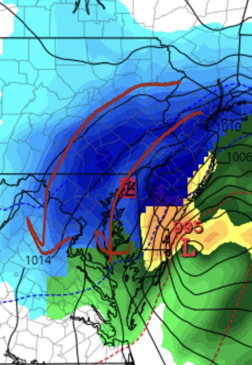
-
Central PA - Winter 2020/2021
AllWeather replied to MAG5035's topic in Upstate New York/Pennsylvania
LSV getting hammered this run -
Central PA - Winter 2020/2021
AllWeather replied to MAG5035's topic in Upstate New York/Pennsylvania
As a Meteorologist by degree I think you have a prime spot. As a (now) Realtor in LancCo, you definitely have a prime spot. Win-win for you either way! -
Central PA - Winter 2020/2021
AllWeather replied to MAG5035's topic in Upstate New York/Pennsylvania
Thanks! Good to be back. -
Central PA - Winter 2020/2021
AllWeather replied to MAG5035's topic in Upstate New York/Pennsylvania
Alright. Now I’m interested.


