AllWeather
-
Posts
609 -
Joined
-
Last visited
Content Type
Profiles
Blogs
Forums
American Weather
Media Demo
Store
Gallery
Everything posted by AllWeather
-

Central PA - Jan 31 to Feb 2 Winter Storm
AllWeather replied to MAG5035's topic in Upstate New York/Pennsylvania
About 4.5” at chateau de la Moore in Manheim. -
Central PA - Jan 31 to Feb 2 Winter Storm
AllWeather replied to MAG5035's topic in Upstate New York/Pennsylvania
17.9” 1.5” liquid -
Central PA - Winter 2020/2021
AllWeather replied to MAG5035's topic in Upstate New York/Pennsylvania
A cigar and a glass of Johnnie Walker Blue Label, please. -
Central PA - Winter 2020/2021
AllWeather replied to MAG5035's topic in Upstate New York/Pennsylvania
I agree, and those numbers will probably change with today's full 12z suite in (or maybe after 00z tonight). Communicating this information to the average Joe is a science in itself. If you prepare people for a 6"+ snow, they typically will hunker down anyways. Then if totals go higher, it doesn't really affect them too much more other than additional clean up because they were already prepped to lay low (obviously if it's a crusher storm, the clean up can linger for days). On the contrary, if you prep people for a blockbuster, and it goes bust - well that affects people in a variety of socioeconomic ways (i.e. they closed their businesses when they didn't have to, took off work to stay home with their kids, etc). These forecasters must walk a fine line....it's easier for the public to understand if you go conservative and get surprised. However pitchforks are way more likely to come out if you overblow it and get surprised the other way. -
Central PA - Winter 2020/2021
AllWeather replied to MAG5035's topic in Upstate New York/Pennsylvania
Thank you for the kind words! And yeah, was always a real balance striking the right tone for a variety of different types of viewers. Some HATE snow, while others love it, so you have to be careful. My goal was always just to lay out what we know and be honest about what we didn’t know, and what could “go wrong” with a forecast. I think people respect that. -
Central PA - Winter 2020/2021
AllWeather replied to MAG5035's topic in Upstate New York/Pennsylvania
Giggity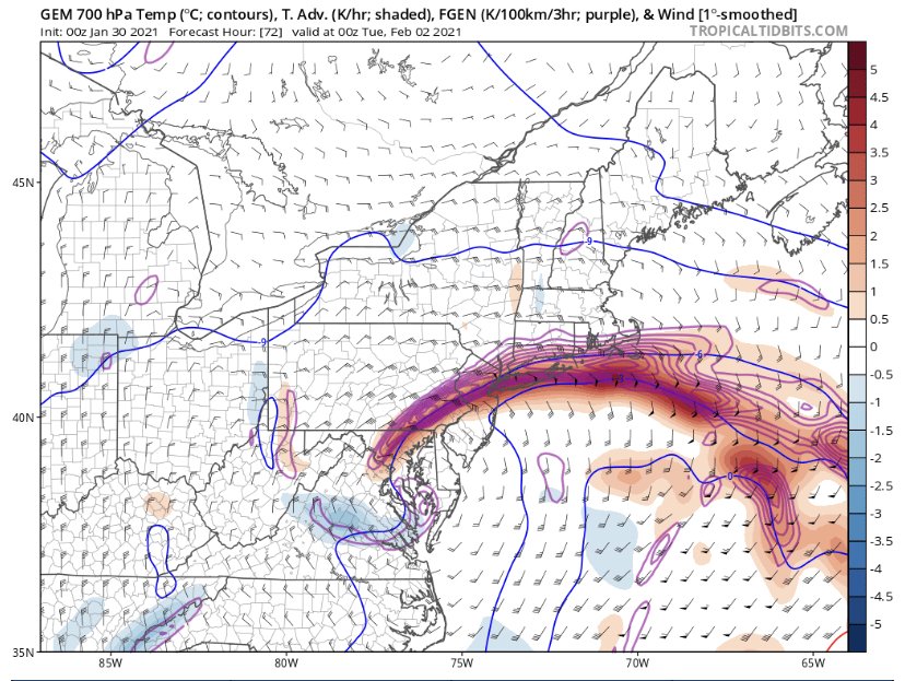
-
Central PA - Winter 2020/2021
AllWeather replied to MAG5035's topic in Upstate New York/Pennsylvania
Doing the showings this weekend! Told my clients to lay low Monday. -
Central PA - Winter 2020/2021
AllWeather replied to MAG5035's topic in Upstate New York/Pennsylvania
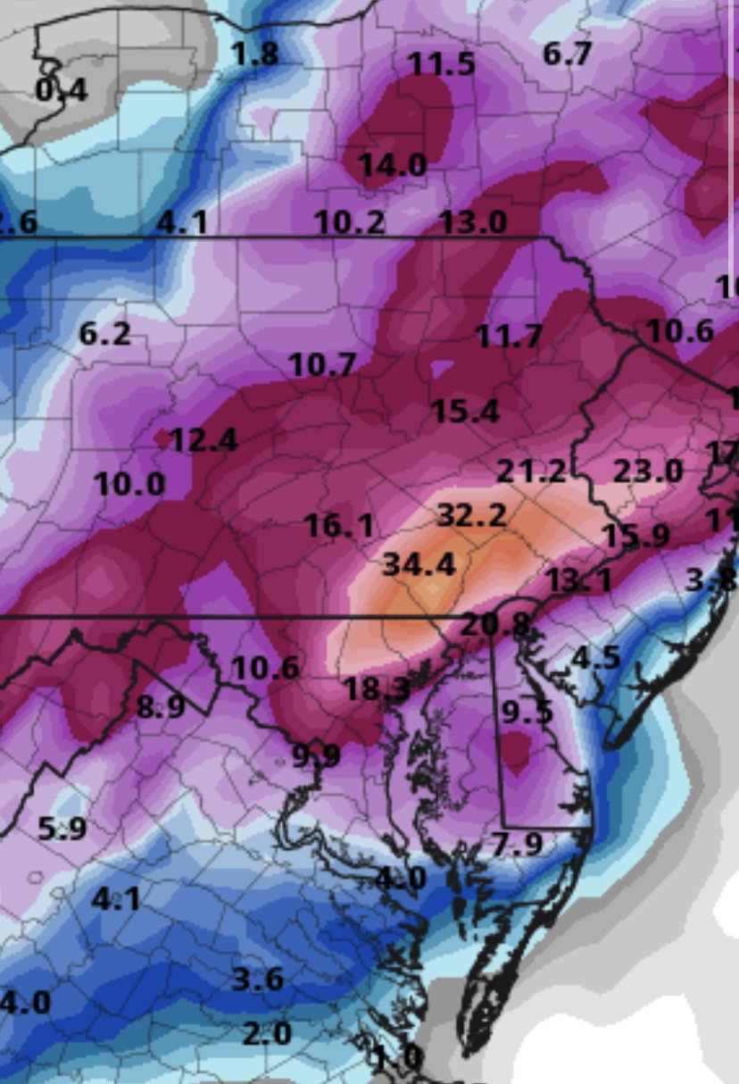
It’s the frame after that that gets fun. Mixing does creep north, but once CCB forms it gets squashed. See a 4”+ QPF lollipop in there around southern Lanc Co. That’s wild. -
Central PA - Winter 2020/2021
AllWeather replied to MAG5035's topic in Upstate New York/Pennsylvania
00z CMC Kuchera
-
Central PA - Winter 2020/2021
AllWeather replied to MAG5035's topic in Upstate New York/Pennsylvania
Lanc Co has 36”+ per TT and still snowing. -
Central PA - Winter 2020/2021
AllWeather replied to MAG5035's topic in Upstate New York/Pennsylvania
CMC is a mauling. -
Central PA - Winter 2020/2021
AllWeather replied to MAG5035's topic in Upstate New York/Pennsylvania
And it’s still snowing on the last frame. -
Central PA - Winter 2020/2021
AllWeather replied to MAG5035's topic in Upstate New York/Pennsylvania
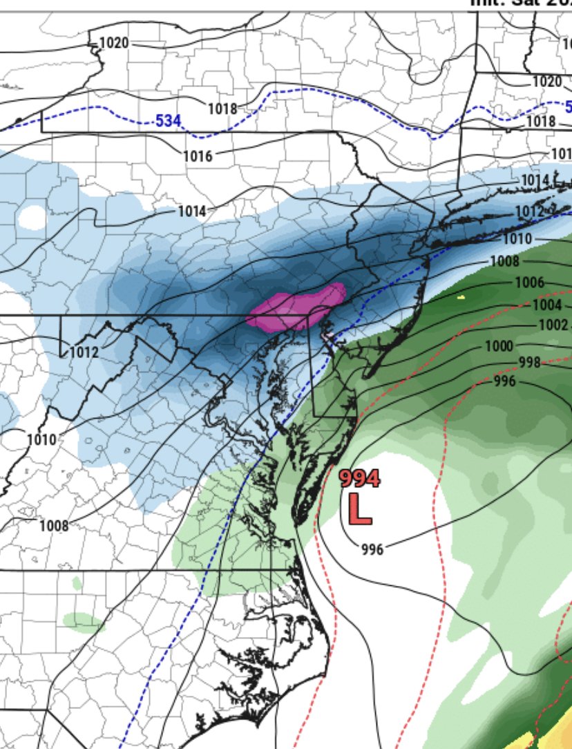
00z RGEM looks tucked and amped up.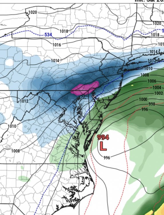
-
Central PA - Winter 2020/2021
AllWeather replied to MAG5035's topic in Upstate New York/Pennsylvania
Problem with Miller Bs. If you’re caught between the handoff you can be in that “screw zone” of subsidence. -
Central PA - Winter 2020/2021
AllWeather replied to MAG5035's topic in Upstate New York/Pennsylvania
Seems like it's all I have time for lately - the real estate market is INSANE right now. That being said... These Miller Bs are always butt clenchers....always. So many things can go wrong. That being said, I like the southern/southeastern half of the state per the ensembles. I also think with that anomalous fetch off the ocean, some underplaying in QPF on the globals is likely. -
December 16 2020 CTP Snowstorm Disco and Obs
AllWeather replied to pasnownut's topic in Upstate New York/Pennsylvania
Like this: edit: look at that band in N PA into NY. Wow!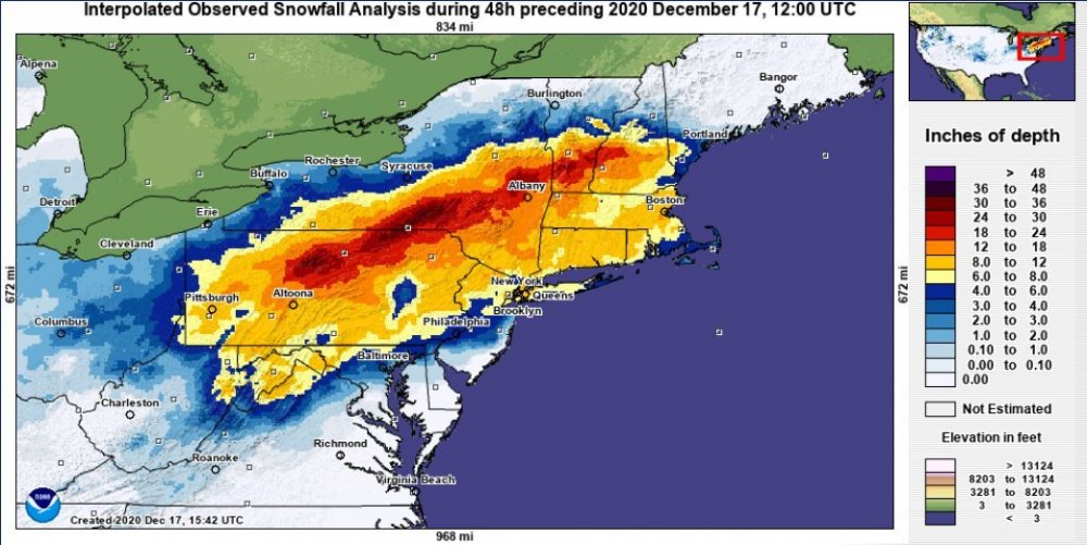
-
December 16 2020 CTP Snowstorm Disco and Obs
AllWeather replied to pasnownut's topic in Upstate New York/Pennsylvania
There seemed to have some sort of mini max from the Marietta area up into the northern part of the county. -
December 16 2020 CTP Snowstorm Disco and Obs
AllWeather replied to pasnownut's topic in Upstate New York/Pennsylvania
Finished with 11” of a sleet sandwich in Manheim and it’s a beast to shovel. Sprayed some cooking spray on the shovel and that helps! -
December 16 2020 CTP Snowstorm Disco and Obs
AllWeather replied to pasnownut's topic in Upstate New York/Pennsylvania
Sleet in Manheim, Lancaster County. -
December 16 2020 CTP Snowstorm Disco and Obs
AllWeather replied to pasnownut's topic in Upstate New York/Pennsylvania
Golf ball sized snow here in Manheim. The sleet line cometh. -
December 16 2020 CTP Snowstorm Disco and Obs
AllWeather replied to pasnownut's topic in Upstate New York/Pennsylvania
Yeah. That’s the good good right there. -
December 16 2020 CTP Snowstorm Disco and Obs
AllWeather replied to pasnownut's topic in Upstate New York/Pennsylvania
Mesoscale Discussion 1854 NWS Storm Prediction Center Norman OK 1257 PM CST Wed Dec 16 2020 Areas affected...Northeast West Virginia...northern Virginia...western Maryland...and central to eastern Pennsylvania Concerning...Heavy snow Valid 161857Z - 170000Z SUMMARY...Heavy snowfall rates around 2 inches per hour are expected to increase in coverage through the mid to late afternoon hours across portions of the Mid-Atlantic. Heavy snowfall will likely continue into the overnight hours for portions of eastern/northeastern Pennsylvania. DISCUSSION...Precipitation continues to gradually increase in coverage across much of the Mid-Atlantic region within a broad swath of strong warm air advection between 850-700 mb (per recent RAP soundings and mesoanalysis). Mixed precipitation types continue to be reported within the precipitation transition zone along the Roanoke to Fredericksburg, VA line. While a wintry mix, including pockets of freezing rain, will continue in the near term, this zone should become more limited spatially through the mid/late afternoon hours. Further north, moderate, to at times heavy, snowfall rates have been observed (as evidenced by visibility reductions to one-quarter mile and observed snow rates around 2 inches per hour for some locations in northeast WV). Heading through the afternoon, the low that is currently advancing northward along the Carolina coast will continue to deepen. As this occurs, mid-level winds will strengthen and begin to tighten the 850-700 mb baroclinic zone and augment warm advection across the region. As isentropic and frontogenetical lift increase, snowfall rates will see a corresponding uptick in intensity. Lift within the dentritic growth zone and weak instability closer to the coast will help further augment snowfall rates. Widespread snowfall rates above 1 inch per hour over the region are likely, and the potential for widespread snowfall rates exceeding two inches per hour will increase through 00 UTC as the potential for organized frontogenetical/deformation-driven snow bands increases.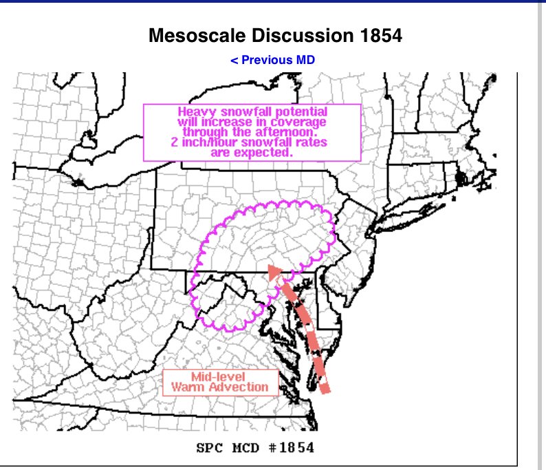
-
December 16-17, 2020 Winter Storm Obs/Nowcasting
AllWeather replied to WxUSAF's topic in Mid Atlantic
Blow it up this way, k? -
December 16 2020 CTP Snowstorm Disco and Obs
AllWeather replied to pasnownut's topic in Upstate New York/Pennsylvania
Yes - though that feature is getting going now as the primary is handing off to the coastal. A lot of what you see on radar is overrunning it appears. -
December 16 2020 CTP Snowstorm Disco and Obs
AllWeather replied to pasnownut's topic in Upstate New York/Pennsylvania
Sounds about right looking at those returns in MD headed this way