

Quincy
-
Posts
6,220 -
Joined
-
Last visited
Content Type
Profiles
Blogs
Forums
American Weather
Media Demo
Store
Gallery
Everything posted by Quincy
-
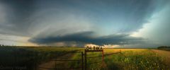
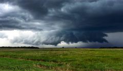
From the album: Spring/Summer 2015
A broadly rotating thunderstorm competes with a nearby storm in the vicinity of McLean, TX. Sept. 20th, 2015. -
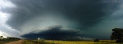
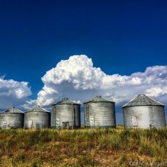
From the album: Spring/Summer 2015
A supercell thunderstorm near peak organization over McLean, TX displays intense inflow with blowing dust in the area. Sept. 20th, 2015. -
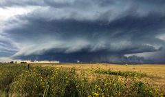
From the album: Spring/Summer 2015
A supercell thunderstorm, the first of the afternoon, begins to organize near McLean, TX. Sept. 20th, 2015. -

Central/Western Medium-Long Range Discussion
Quincy replied to andyhb's topic in Central/Western States
The focus has shifted earlier, but perhaps not enough for a big day on Monday. Although the evening looks interesting, the best environment seems to occur overnight across eastern Texas. It's the 06z-12z time-frame that instability is maximized, as the low-level jet really cranks and mid-level lapse rates steepen. Speed this up a bit and it could be really interesting. Tuesday looks messy, although I could see a potent squall line early in the day with embedded tornadoes. -
Central/Western Medium-Long Range Discussion
Quincy replied to andyhb's topic in Central/Western States
12z model suite continues a strong signal for the lower Mississippi Valley and surrounding subforums to the east. Too soon for details, but this easily looks more impressive than what's going on today. -
Central/Western Medium-Long Range Discussion
Quincy replied to andyhb's topic in Central/Western States
The GFS/Euro show another dynamic system in the Plains about a week from now. Not quite as impressive as this current system and a bit further south, but worth watching later forecasts and trends. -
Central/Western Medium-Long Range Discussion
Quincy replied to andyhb's topic in Central/Western States
Based on the GFS/Euro (12z), certainly have to agree with this. The Euro actually shows the best instability in the east-central Plains at 12z on Wed, lessening with time with movement into Iowa and Missouri. Likewise, the GFS forecast soundings for eastern Missouri and southeastern Iowa are not as impressive as further west/earlier. -
From the album: Spring/Summer 2015
This supercell thunderstorm was in a transition stage. Moments earlier, the storm was displaying a prominent wall cloud, but at this stage, the structure was taking on more of a shelf cloud-like appearance. Near Payne, OH. August 23rd, 2015. -

From the album: Spring/Summer 2015
A short-lived wall cloud drops down close to ground level with a thunderstorm near Grover Hill, OH. August 23rd, 2015. -
From the album: Spring/Summer 2015
A small, rotating, quasi-wall cloud looms in the distance within this scene from an abandoned road near Grover Hill, OH. August 23rd, 2015. -

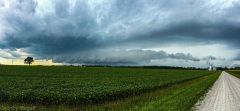
From the album: Spring/Summer 2015
A thunderstorm approaches farmland of corn and wind turbines just south of Payne, OH. August 23rd, 2015. -

From the album: Spring/Summer 2015
A shelf cloud associated with a strong thunderstorm hangs over a wind farm in rural northwestern Ohio. August 23rd, 2015. -
Central/Western Medium-Long Range Discussion
Quincy replied to andyhb's topic in Central/Western States
I've been casually watching Sunday across the north-central states. A lot can change and there has been some model adjusting, but keeping an eye on a vigorous shortwave forecast to eject across the northern Plains Sunday into early Monday. There may be somewhat of a disconnect between the best forcing, strongest wind fields and the warm sector, but details can be ironed out in the coming days. Based on model indications now, I'd peg the focus on the eastern Dakotas into the Upper Midwest as an area to keep an eye on. Nothing significant and not outbreak-material, but the way this year has gone, at least it's something on the radar. I wonder how this fall will shape up, if it may try to pull a 2013 or keep the trend of generally lackluster severe threats. I'd tend to lean toward the latter. -

From the album: Spring/Summer 2015
While this supercell thunderstorm had an eerie, ominous appearance, the storm was struggling to organize. As a result, the storm continued to slowly weaken after this August 9th, 2015 photo in far southeastern South Dakota. -
From the album: Spring/Summer 2015
A thunderstorm looms over a farm across the rural northern Plains near Parkston, SD. August 9th, 2015. -
From the album: Spring/Summer 2015
A rainbow is partially obscured by clouds and distant rain over Parkston, SD. August 9th, 2015. -

From the album: Spring/Summer 2015
A long-hanging cloud base with a rotating thunderstorm southwest of Ethan, SD gives the impression that the storm is circling the sky. August 9th, 2015. -
From the album: Spring/Summer 2015
As pictured from Storla, SD, a thunderstorm grows in the distant northwest sky. August 9th, 2015. -
From the album: Spring/Summer 2015
This tornado-warned supercell just west of Storla, SD featured a ground scraping wall cloud. Although the storm was rotating, neither a tornado nor a funnel cloud was observed. August 9th, 2015. -
A series of supercell thunderstorms moved through central and eastern Massachusetts this afternoon. Some of the storms prompted tornado warnings and there were multiple significant severe weather reports as a result. Some of the thunderstorms originated as far west as eastern New York and later reached peak intensity as they moved into portions of central and southern New England. Even the coastal community of Boston was hit with some regionally impressive severe weather. The prelude to these afternoon storms actually came in the form of early-day severe storms this morning. A line of severe wind-producing thunderstorms affected portions of southeastern Connecticut, Rhode Island and Cape Cod. An area that does not often see severe weather, especially during the morning hours. Once those storms moved out, there was some clearing, which led to plenty of daytime heating to fuel another round of thunderstorms. By early afternoon, there was an area of moderate to strong instability developing across the eastern half of Massachusetts, coinciding with seasonably strong wind shear. The mesoanalysis showed a corridor of moderate buoyancy coinciding with more than adequate wind shear for supercell thunderstorms. Bulk wind shear was in excess of 50 knots across the region. With clusters of thunderstorms ongoing across portions of the area, the storm mode was going to be critical in the evolution of the event. If storms merged, lines would form, suggesting more of a damaging wind threat. If the storm mode was messy, the inflow region and overall environment could be disrupted, resulting in mainly sub-severe storms. However, if any storm could remain discrete and from on the southeastern fringe of the activity, in order to take better advantage of stronger instability, then things would become a bit more interesting. Two thunderstorms began to split in northern Worcester County shortly before 2 p.m. The northern most storm tracked east-northeast into far southern New Hampshire. This storm merged with surrounding storms and did not strengthen much. The southern storm took a bit of a right turn and continued in a generally eastward direction. This cell moved through northern Worcester County, organizing quickly into a robust supercell. Velocity and hail signatures increased, indicating the likelihood of 1-2″ diameter hail. This storm further organized with rotation becoming more focused. A hook was noted on radar and a Tornado Warning was issued. The storm continued into northern Middlesex County, dropping more large to significant hail, but the velocity signature was marginal at best for tornadic development. The main story was hail. Speaking of hail, a second supercell developed on in west-central Worcester County a short time later. This storm was semi-discrete, but remained that way for quite some time. It also dropped large hail and continued for two more hours, moving right through downtown Boston. Large hail was reported throughout portions of the city and surrounding areas. Overall, there were numerous reports of golf ball or larger hail across Massachusetts, with at least three confirmed reports of hail at least two inches in diameter. A few additional discrete storms developed later in the afternoon, but earlier storms had overturned the atmosphere a bit. These storms were generally strong to only marginally severe in nature. No tornadoes have been confirmed as of 10:00 p.m. Although there was some localized backing of low-level wind fields, the lack of favorable low level helicity was a limiting factor in the tornado potential. Nonetheless, a fairly uncommon significant hail event affected the eastern half Massachusetts, an area that based on a 1980-2006 average, only reports significant hail once every 6.75 years. This is based on four reports across all of eastern Massachusetts, during the time. While there were four significant hail reports in that 27 year span, there were three such reports this afternoon alone. Keep in mind that the time of record is relatively short, as reports from 2007 to this year were also not included. A look at the 2 p.m. mesoanalysis showing 1000-1500+ J/kg MLCAPE and locally backed near-surface winds in the vicinity of the most robust supercells:
-

From the album: Spring/Summer 2015
A supercell thunderstorm continues to grow over Cambridge, NE . May 15th, 2015. -

From the album: Spring/Summer 2015
A severe thunderstorm fades into the night in southwestern South Dakota. July 4th, 2015. -

From the album: Spring/Summer 2015
The sun sets amidst a lone sunflower in Minneola, KS. July 3rd, 2015. -
From the album: Spring/Summer 2015
A thunderstorm begins to form in the distance, over western Kansas, as photographed from far eastern Colorado. July 3rd, 2015. -

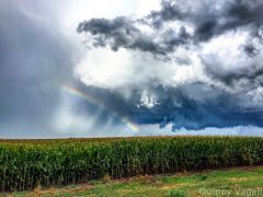
From the album: Spring/Summer 2015
A vibrant double rainbow appears to hover over a field of corn in northern Missouri. June 28th, 2015.