
DopplerWx
-
Posts
3,398 -
Joined
-
Last visited
Content Type
Profiles
Blogs
Forums
American Weather
Media Demo
Store
Gallery
Everything posted by DopplerWx
-
The December to Remember 7th-8th blue turd winter threat thread.
DopplerWx replied to lilj4425's topic in Southeastern States
another inch or so on the back end for western nc and ga, what a great storm for you guys. -
The December to Remember 7th-8th blue turd winter threat thread.
DopplerWx replied to lilj4425's topic in Southeastern States
also this should scare you if you have visions of clown maps dancing in your head, models may be underdoing the warm nose (imagine that) Jonathan Wall @_jwall RDU flight observed sounding vs SREF from last night. Notice shallow warm layer from 900-1000mb and the tiny warm nose just before 800mb. It’s as if it was trying to tell us something! -
The December to Remember 7th-8th blue turd winter threat thread.
DopplerWx replied to lilj4425's topic in Southeastern States
warm nose right now looks very similar to the hires nam and hrrr from last night. when you have both of them showing the snow line above you it is usually the kiss of death. -
The December to Remember 7th-8th blue turd winter threat thread.
DopplerWx replied to lilj4425's topic in Southeastern States
i understand being wary of the hrrr but to think it is going to be THIS off? not likely. this is one of those warning shots the day before a storm that you ignore at your own peril. -
The December to Remember 7th-8th blue turd winter threat thread.
DopplerWx replied to lilj4425's topic in Southeastern States
the HP is sitting in the midwest, much different than here. hrrr does not have a warm bias that i have seen, has nailed MANY rain/snow lines over the past few winters. -
The December to Remember 7th-8th blue turd winter threat thread.
DopplerWx replied to lilj4425's topic in Southeastern States
**every other short range model's snow maps with 10:1 ratios -
The December to Remember 7th-8th blue turd winter threat thread.
DopplerWx replied to lilj4425's topic in Southeastern States
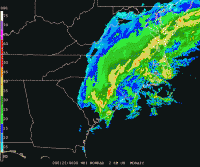
hrrr tomorrow afternoon, no snow to be found in ga, sc or much of nc. -
The December to Remember 7th-8th blue turd winter threat thread.
DopplerWx replied to lilj4425's topic in Southeastern States
newest hrrr has a steady cold rain tomorrow for all of sc and nc outside of the mountains at noon. -
The December to Remember 7th-8th blue turd winter threat thread.
DopplerWx replied to lilj4425's topic in Southeastern States
remember when the hrrr was showing it ripping fatties tomorrow morning in nc? here's the latest run. -
The December to Remember 7th-8th blue turd winter threat thread.
DopplerWx replied to lilj4425's topic in Southeastern States
hires nam showing the snow line not as far south and east as the 12km nam, FYI. -
The December to Remember 7th-8th blue turd winter threat thread.
DopplerWx replied to lilj4425's topic in Southeastern States
agreed. as the low cranks offshore the precip should end as light snow showers for most. that is a good start to winter in my book. -
The December to Remember 7th-8th blue turd winter threat thread.
DopplerWx replied to lilj4425's topic in Southeastern States
you can't be too surprised if it does trend warmer and most see cold rain, the setup was marginal at best for nc, many just got overexcited by 10:1 ratio snow maps. -
The December to Remember 7th-8th blue turd winter threat thread.
DopplerWx replied to lilj4425's topic in Southeastern States
because we are getting closer to the event and we are at the max range of the hrrr. if it keeps trending warmer everyone hoping for the clown maps to verify better temper their expectations quickly. have seen this song and dance many times. -
The December to Remember 7th-8th blue turd winter threat thread.
DopplerWx replied to lilj4425's topic in Southeastern States
past 2 hrrr runs have really warmed for much of nc for tomorrow. 21z run: 23z run: -
The December to Remember 7th-8th blue turd winter threat thread.
DopplerWx replied to lilj4425's topic in Southeastern States
hrrr was pretty accurate last jan but the snow line ended up ~50miles or so north of where it was forecasted, had me safely in the snow and ended up with rain and sleet. just a forewarning. -
The December to Remember 7th-8th blue turd winter threat thread.
DopplerWx replied to lilj4425's topic in Southeastern States
gfs even warmer thru 36, precip a bit west -
The December to Remember 7th-8th blue turd winter threat thread.
DopplerWx replied to lilj4425's topic in Southeastern States
brutal warm nose on the hi-res nam. upstate sc looks like snow initially with the heavier rates but quickly goes back to rain. clt east looks like all rain. -
The December to Remember 7th-8th blue turd winter threat thread.
DopplerWx replied to lilj4425's topic in Southeastern States
this will be killer for snow chances just like last year, another snowstorm a couple thousand feet up. going to be very difficult to overcome a 3c warm nose. Jonathan Blaes @jlblaes 5 minutes ago Snow lovers, Rut Roh! The 12/07 06Z NAM BUFR forecast for KRDU is picking up on a developing warm nose Friday night. At 2am, snow aloft is falling but likely melts in the ~3C warm nose near 775 mb. The +2C surface temp and warm ground limit accumulations. #ncwx -
The December to Remember 7th-8th blue turd winter threat thread.
DopplerWx replied to lilj4425's topic in Southeastern States
going to have wet grass and wet roads, little to nothing will stick outside of car tops and elevated surfaces. model sees .2" qpf falling as snow and paints it on a clown map that people get excited about when .18" of that qpf will melt as soon as it makes contact. -
The December to Remember 7th-8th blue turd winter threat thread.
DopplerWx replied to lilj4425's topic in Southeastern States
3k nam has pretty much all rain for clt to rdu east. warm nose rears its head. -
The December to Remember 7th-8th blue turd winter threat thread.
DopplerWx replied to lilj4425's topic in Southeastern States
theres a good look at the power of the warm nose at 51hr. -
The December to Remember 7th-8th blue turd winter threat thread.
DopplerWx replied to lilj4425's topic in Southeastern States
yep, we all tried to ignore it 36-48hrs out last jan and it ended up being even stronger than modeled. -
The December to Remember 7th-8th blue turd winter threat thread.
DopplerWx replied to lilj4425's topic in Southeastern States
anyone hoping the warm nose isnt as strong as modeled on the hi-res nam is going to be very dissapointed. -
The December to Remember 7th-8th blue turd winter threat thread.
DopplerWx replied to lilj4425's topic in Southeastern States
more precip but warmer at 78. a cold rain for most in nc. -
The December to Remember 7th-8th blue turd winter threat thread.
DopplerWx replied to lilj4425's topic in Southeastern States
yep. every ensemble for the gfs and euro were showing 10"+ the morning of the storm and we got a cold rain and some sleet because of the warm nose. i really don't see any reason to expect more than some token flakes rdu north with this one.
