
DopplerWx
-
Posts
3,398 -
Joined
-
Last visited
Content Type
Profiles
Blogs
Forums
American Weather
Media Demo
Store
Gallery
Posts posted by DopplerWx
-
-
-
1 minute ago, Amos83 said:
yep for sure.... that one really hacked me off and why I'm so gun shy with this one. the type of snow being shown on the models is rare for around here so our caution should be even more warranted this go around. Although which each passing model run it is getting hard to contain the excitement for sure
to me it seems likely we see initial snow sat night into sunday morning before a changeover, no matter what that is a win this early in december. give me an inch or 2 and i will be more than happy.
-
 1
1
-
-
3 minutes ago, Amos83 said:
The fact that this is an ensemble mean is absurd. As much as I want to get deliriously excited about this I think we need to remember that we will for sure be dealing with WAA at some point, no way we will get such a juiced up storm and not have it. WAA is very hard to forecast and many times it comes it stronger than anticipated.
Having said that it is beautiful to see these runs continue over and over
i know we keep saying it but jan 2017 storm had the ensembles showing insane totals just like these and the waa screwed many of us. expecting a loooot of sleet with this one.
-
3
-
 1
1
-
-
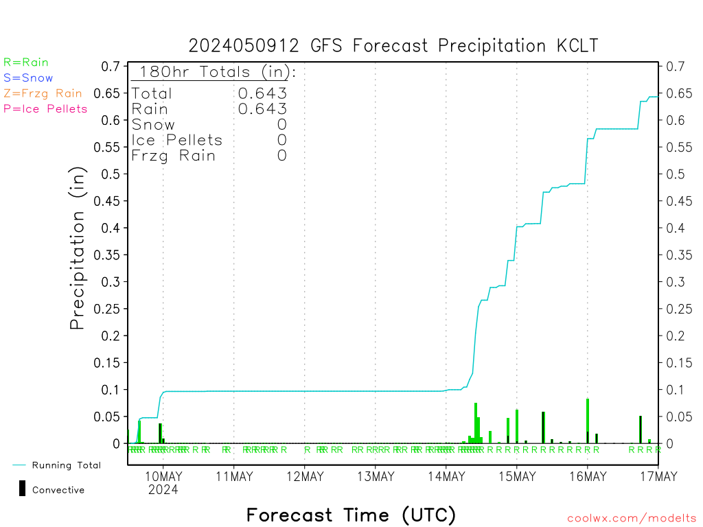
here is an image to save, from the 12z gfs for charlotte lol.
-
1
-
 1
1
-
-
it is about to transfer offshore sc. just like 06z.
-
1
-
-
fv3 looks very similar to the gfs at 96hr.

-
3
-
-
Just now, griteater said:
source for early FV3?
TT fv3 sim radar
-
1
-
-
fv3 a bit south with our lp out to 66.
-
1
-
-
going ahead and making my reservation for sunday in the sanitarium.
-
2
-
-
Just now, ryan1234 said:
Having that transition line right there at SC Highway 9 is still a bit worrisome. I'd like to see it 50 miles south of there, at least for the CLT metro.
hoping we can get it to keep trending cooler over the next 3 days.
-
3 minutes ago, WxKnurd said:
Phil’s Coefficient radarscope will be getting a workout by me for this one, like always these last few years.
now that is the kiss of death, will never forget when he popped in the jan 2017 thread and fired the warning shot.
-
2 minutes ago, burgertime said:
Take your chances with that. I think you still end up with a sleet/snow profile...what no one wants is ZR. If that warm nose sets up shop (and it almost always does) that will not be good for CLT.
agree but soundings have improved over the past 6 runs or so. still expecting the nam to show that warm nose about 36hrs out once we are all nice and excited.
-
1
-
-
backside is juicy too, man if these soundings verified for kclt, what a monster storm it would be.
-
charlotte sounding at 96 w/ heavy precip. we like to live dangerously.


-
1
-
1
-
-
at 96, oh mama. beautiful look.

-
dps a bit better and the snow line is maybe a tick south.

-
icon still showing initial snow in clt thru sunday morning before changing to rain for areas even to asheville.
-
4 minutes ago, burgertime said:
I think this could be a great analog. Could see getting a good storm with layers...don't think CLT gets a foot but I could def see 6 inches with an inch of sleet and some frozen rain/drizzle thrown in at the end....and then a bump of snow again at the end.
yea looking at soundings on the 6z gfs clt looks all snow thru 96 then a warm nose pops up at 102 turning us to sleet. encouraging that the warmer gfs shows a nice front end thumping. if we can get the nam thermals to verify we would be in even better shape.
-
1
-
-
6z gfs has clt right on the rain snow line and in turn spit out these ridiculous numbers. i don't buy it though, i think we see a lot more sleet and a lot more rain than snow.

-
and then the low jumps over myrtle and the obx and areas outside the mtns go to rain
-
yea sounding looks much better at kclt this run. all snow thru 96.

-
1
-
-
looks like a snow sounding thru 102 at clt. maybe a bit colder this run?
-
1 minute ago, Orangeburgwx said:
Faster and further north
its identical at 84.
-
1
-
1
-
-
3 minutes ago, burrel2 said:
I'm not concerned. The Euro isn't showing a lee-side warm bubble from northwest flow over the mountains, as that's not where our cold air is coming from. 925mb temps are actually at their coldest on an axis through this area for our storm. (Thanks to CAD). It's a big reason we wind up getting mostly sleet in freezing rain events while places around us get more freezing rain.
I think the euro snow map has a bubble over Oconee county simply b/c it's showing surface temps at 33 degree's there for 5 or 6 hours while surrounding area's are 32/31. I've seen this before in CAD set ups, especially as the CAD is first coming in, it's gets to places like anderson/hartwell a little faster than that small area over Oconee, but it's nothing to worry about right now. It will wind up being largely over-done, imo, (assuming the general depiction is right).
However, it is yet another reason why that small geographic area is literally the worst place you can live for winter weather.
if the gfs is correct w/ the lp location then the warm nose would def mess with you guys. sounding in the midst of the precip shows it.

December 8-10, 2018 Winter Storm
in Southeastern States
Posted
ukie verification scores lately have been pretty solid too. above even the fv3