

OHweather
-
Posts
4,957 -
Joined
-
Last visited
Content Type
Profiles
Blogs
Forums
American Weather
Media Demo
Store
Gallery
Everything posted by OHweather
-
Winter 2022/23 Medium/Long Range Discussion
OHweather replied to Chicago Storm's topic in Lakes/Ohio Valley
Kind of interesting to watch how the pattern has evolved from November 1 through early January. In general, for November and the first half of December, we had a north Pacific/Aleutian ridge that frequently resulted in a western US trough...a -PNA/fairly typical La Nina pattern, with what could be characterized as a relatively weak/retracted Pacific jet stream. Since then, we've switched to a strong north Pacific/Aleutian low, which is blasting the Pacific jet stream into the west coast and cutting off an Arctic influence into the CONUS. This can be characterized as a very strong and extended Pacific jet stream, more typical of an El Nino. While the Pacific has been the issue preventing sustained cold for much of the late fall/early winter, it's been because we've gone from one extreme to another, with only a brief period in between in mid-late December where we managed a more favorable pattern for widespread cold in the CONUS. We have had blocking at times...the Aleutian ridge flexed to the point where it was a -EPO that facilitated cross-polar flow at times in November and December (which is the typical way to get Arctic shots in a La Nina), and we had a relatively robust -NAO for most of December...but we've seen a mix of Pacific patterns that are different but mild for the central/eastern CONUS in their own ways and have torched when blocking relaxes. The Pacific jet stream will weaken considerably over the next week, finally, as much lower pressure over eastern Asia (a negative mountain torque, which requires a loss of westerly atmospheric momentum/a weakening of the jet stream to compensate) and a downturn in convection over the western Pacific warm pool (resulting in less latent heat release and a weakening of the gradient over the western Pacific, also weakening the Pacific jet) both suggest a quick loss of westerly momentum over the Pacific. This is why ensembles are hinting at the trough backing away from the west coast and allowing heights to rise at least somewhat after mid-January. My guess is we transition back to a more typical Nina pattern into February when tropical forcing returns to the western Pacific and enhances the lingering La Nina circulation, but with perhaps another one of our "brief windows" in between where we can get a ridge along the West Coast in a spot that can increase polar/arctic influence into the central and eastern CONUS for 1-2 weeks around the end of January/early February as we make that transition..gif.ca8ad0c3f21e39a6d3179dd295a3119d.gif)
.thumb.gif.b7ef85c3830021fff9b1d419a31f3031.gif)
-
Merry Christmas! The LES warnings for Lake and Ashtabula today may not quite have been needed as it lifted back over the lake pretty quickly into this morning, but still a white Christmas with plenty of snow on the ground. In Mentor for dinner and probably a couple more inches on the ground here compared to Reminderville but nothing too crazy.
-
Pre-Christmas (Dec 21-23rd) Winter Storm Part 2
OHweather replied to Chicago Storm's topic in Lakes/Ohio Valley
Only about 4” or so of snow here, but many sites in northern Ohio and northwestern PA, including both Cleveland airports and Erie, met official blizzard criteria today. Here’s CLE 5 minute obs: https://www.weather.gov/wrh/timeseries?site=KCLE Note the <0.25 mile stuff, solid blizzard conditions from 8am-3pm and briefly 6-7am. Port Clinton OH is even more impressive, look at those gusts over 60 with temperatures below 0! https://www.weather.gov/wrh/timeseries?site=KPCW Areas east of I-75 over towards Lorain OH are more open and had extensive issues with blowing snow, including a fatal pileup on the turnpike. -
Several sites easily verified blizzard conditions today, with visibility frequently below 1/4 of a mile and gusts well over 35mph…along with sub zero temperatures. Cleveland Hopkins, Burke Lakefront, Lorain County, Port Clinton, Lost Nation (Willoughby), Akron Canton, and Erie all hit it for 3 hours straight or longer. Findlay, Akron Fulton and Youngstown have strong arguments but didn’t quite get into the sub 1/4 mile stuff for 3 straight hours, so it’s more debatable. Mansfield, Wooster and Ashtabula also met conditions briefly, but weren’t really close to doing it for 3 hours. CLE verified a blizzard from 8am to 3pm! And briefly around 6-7am! https://www.weather.gov/wrh/timeseries?site=KCLE Not nearly as bad as what Buffalo is dealing with and not in the same league as 1978, but we can say we experienced a blizzard today which is uncommon around these parts. The cold and wind combination was unique. Estimating a bit over 4” of snow here, and we are still getting the occasional house shaking gust.
-
It took a while for everyone agreeing on upgrading to the blizzard warning but it seems to have been worth it for the conditions. It was and still is pretty brutal out there.
-
The warnings for that area said 2-4” and you’re gonna get the 2” instead of the 4”…this was never going to produce big snow totals in OH, although the I-71 corridor is looking to be the ones who get luckier in those regards as opposed to NW OH.
-
Definitely some noted trends for the post frontal snow to be a bit more robust tonight, even in central and southern Ohio. There isn’t a crazy ceiling here but even many of you folks getting a solid few inches down there seems more plausible now.
-
Definitely some snowier trends with the post-frontal burst later tonight into tomorrow morning for a good portion of central and eastern OH. Thinking the Cleveland area has a good 4-6” down by midday with whatever light wraparound comes after. Curious to see how my drive back down 480 goes at 8 or 9am assuming I choose to try it.
-
Pre-Christmas (Dec 21-23rd) Winter Storm Part 2
OHweather replied to Chicago Storm's topic in Lakes/Ohio Valley
I'm pretty worried about something similar playing out in parts of NW Ohio tomorrow through at least early Saturday, where they're getting 2-4/3-6" of snow with 50-60mph wind gusts for a very prolonged period. Just for the sake of picking your brain a bit, do you know if there was blowable snow already on the ground that made that worse? And I guess my other question, was the strongest wind with the heaviest snow, or did it occur afterwards? Because to me, the new snow amounts, wind and duration of it in NW Ohio (which, like northern IL outside of the Chicago area, is actually quite flat and open) seems at least as bad as what resulted in the impacts described in that entry, though the strongest winds probably start ramping up after the heaviest snow. I could see parts of NW Ohio being absolutely crippled tomorrow into the weekend though. -
Pre-Christmas (Dec 21-23rd) Winter Storm Part 2
OHweather replied to Chicago Storm's topic in Lakes/Ohio Valley
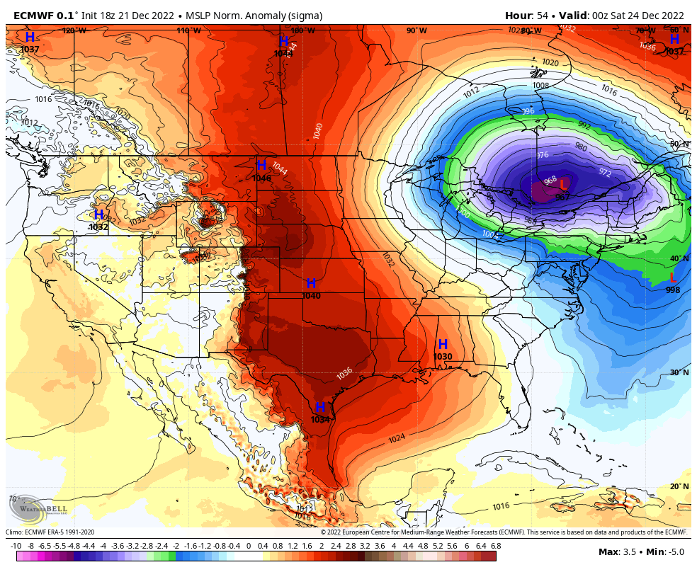
Euro trending a little more amped in recent runs I am really worried about the wind from parts of lower MI, IN, and OH into southern Ontario, northwestern PA and western/northern New York. You have a 5 standard deviation low followed by a 3.5 standard deviation high, very strong cold air advection, with flow funneling down the Great Lakes basin. Gusts could reach 60+ mph in a large portion of that corridor, with up to 75mph downwind of Lake Erie into the Buffalo and Rochester areas. Huge impacts in parts of that corridor, especially downwind of the lakes where lake enhancement will occur..thumb.gif.4763a0e27d080003bc86d1dbf2116a45.gif)

-
This is not the most exciting storm if you're simply going for big snow amounts/rates (though, rates will briefly rip pre-dawn Friday behind the front). I'm guessing public perception will be super mixed...people who have been hearing about a huge storm for days but stay inside on Friday will be underwhelmed when/if we only get a few inches of snow. But, those who hear we're only getting a few inches of snow and venture out on Friday will probably be caught off guard by how brutal the conditions are. Roads really will not be fun Friday through early Saturday with the flash freeze/quick snow accum early Friday followed by intermittent snow and extensive blowing/drifting snow. As for my expectations, I still think a 3-6" type snow (more up the eastern lakeshore from LES, but I'm also not optimistic in much of a lake boost into NE Ohio...maybe north of I-90 from Lake County points east gets some more help) with 50-60 MPH wind gusts and brutal wind chills (-20 to -30F seems quite likely Friday through early Saturday) is a lock. I think we all get a quick 1-3"/2-4" burst behind the Arctic front...it won't last long, but the upper dynamics are briefly very supportive early Friday before we dry slot. The GFS continually deepens the low a bit quicker and slows it down, giving us more wrap-around later Friday into Friday night, and would support probably a 6-10" type snow (the front, plus several more inches of wrap-around). My impression is it's overdone, but it's insistent and given how closed off/deep the trough aloft is, perhaps there's room for the system to intensify and slow down slightly quicker. The Euro is not THAT different than the GFS but deepens the low a bit slower and lifts it northeast slightly quicker, so we get less QPF with the wrap-around. However, the Euro still suggests deep saturation through the low and mid-levels through early Saturday and has mid-level warm air advection/isentropic lift late Friday into Friday night, as the low occludes and warm air aloft starts wrapping back in from the north, so I think the Euro would still bring some wrap-around snow...but, it's much less dramatic than the GFS. The GFS solution still casts doubt on the winds. All models suggest we have no problem mixing to about 850mb Friday afternoon into Friday night, and all models suggest at least 50 knots of flow at that level. So, I think 50-60 MPH gusts (lakeshore and NW Ohio more 60, interior NE Ohio more 50) are still likely across the board. The GFS (and the FV3 WRF) have 850mb winds of 60-70 knots in that window, and soundings from the GFS and FV3 suggest widespread 60mph gusts, even inland, with potential for 70+ right against the lake is possible. That's probably the difference between a typical amount of power outages and something more widespread. With how cold it is until early next week, more than isolated power outages could quickly become an issue with homes getting cold and potential damage to infrastructure. A general rule of thumb given the setup being quite favorable for strong winds is that the wind speed in knots at 850mb Friday afternoon through Saturday roughly correlates to surface gust potential in MPH (i.e. 60 knots at 850mb probably supports 60 mph gusts...the lakeshore may do even better). Still another day to watch trends. I've largely punted LES potential for most of us but do think there's room for trends with the wrap-around snow and what the peak wind gusts end up being, which still is the difference between an impressive/impactful storm and something more life-threatening. Will the GFS trend weaker/faster, or will other models trend stronger/slower? That's the question...
-
Yeah, I agree with your overall sentiments and concerns...though, still time for trends which can impact the overall severity of the storm in our area (and everyone else's). The overall evolution is pretty locked in, wholesale changes are not coming and this will be a significant event for a very large area. The very cold temperatures and strong, possibly damaging winds are locked in and any amount of snow will be a problem given those two factors. Now, I do think snow amount matters...I think there's still ceiling for a 4-8/6-10" type snow event in northern Ohio. It's probably less than likely, I feel like 3-6" is more likely, but there will be a lot of forcing and some embedded heavier bands of snow on the west/southwest side of this low pressure as it dramatically deepens Thursday night through Friday night and many models continue to flirt with that impacting northern Ohio which is how those higher amounts could come into play. Amounts will gradually drop off to the south, but it seems like the whole state gets at least a couple inches. However, while I agree that 2" of snow will be made much worse by the cold and wind, 6"+ is just that much more to blow around and makes it substantially worse. My "baseline expectations" remain similar to above...by baseline, I have relatively high confidence that things will be AT LEAST this bad: -A couple to a few inches of snow seems like a likely low end. Perhaps a brief burst of accumulation right behind the Arctic front early in the day Friday. Likely a dry slot behind the front, then wrap-around snow returning later Friday into Friday night, transitioning to SW flow lake effect on Saturday. -50 to 60 mph wind gusts seem quite likely, and they may be stronger. Strongest winds generally Friday afternoon and Friday night as the pressure gradient really cranks, but probably a brief surge to 50+ mph gusts immediately behind the front early Friday given the extreme pressure rise and dramatic temperature drop. -Temperatures drop from the upper 30s/lower 40s to the single digits in about 6 hours Friday morning behind the front. Temperatures stay in the single digits or teens all weekend, and may dip below 0 Friday evening, especially in western Ohio. Wind chills of -15 to -25 seem likely Friday afternoon through Saturday night, and there's some potential for -30 or colder Friday afternoon into Friday night if winds are on the higher side and temperatures are at least as cold as expected This is a notable storm with very difficult to impossible travel Friday through Saturday morning due to a flash freeze, accumulating snow, and substantial blowing and drifting snow to go along with scattered tree/power-line damage and some power-outages from the wind. Northwestern Ohio, due to its openness, and the lakeshore, due to higher gusts, will probably see the most significant issues from the blowing and drifting, though everyone will see significant blowing and drifting of whatever snow falls. In addition, it'll be dangerously cold outside. This is kind of like a "realistic floor", unless wholesale changes occur (unlikely) we can expect it to be at least that bad. Now, it could be even more significant too. I already mentioned the snow. The subtle trend east on the 0z guidance showed all models depicting 4-8" or so type snow amounts in most of northern Ohio. That's not a slam dunk yet, but is possible. Temperatures may be a bit colder than modeled given the origins of the airmass, though that could be somewhat dependent on getting a good, deep snowpack so is not a given. Winds could also be stronger than the 50-60 MPH I mentioned, especially in western Ohio and then in the northern couple tiers of counties points east. This system checks a lot of boxes for high wind potential...very strong cold air advection, a very tight pressure gradient, an unusually deep low that's still intensifying when we see our strong winds, and also a large tropopause fold accompanying this system. When winds overperform, some or all of these factors are in place. Given the 850mb winds progged to reach at least 65-75 knots somewhere on the backside of the low pressure Friday into Friday night, with some models showing 80+ knots, the other very favorable factors suggest that gusts could be into the 60-70 MPH range, locally stronger where the strongest 850mb winds occur. Will that occur over northern Ohio? Not sure yet, but again many models show gusts of that magnitude here or nearby so it's within the realm of possibility. If some or all of these factors trend more significant, it ups the potential for more widespread power outages along with true, significant blizzard conditions for parts of western and northern Ohio. So to sum up, very high confidence in a widespread significant impact from bitter cold, strong winds, and some snow accumulation. Some potential for more extreme, life-threatening impacts if snow or wind trend higher, which some guidance suggests is possible. With the amount of people planning to travel ahead of the holiday, this is a big deal. We have had internal discussions on potential headlines, timing of them, and messaging. Headlines will be done with extensive collaboration with all surrounding offices and WPC...there's already been a concerted effort to help steer the message and headlines. Given the scope of the system and overall confidence in impacts, expect headlines to be issued on the early side of normal. We still have a couple of days to watch trends and see if it's just a widespread high-impact event, or if locally more extreme impacts end up playing out closer to our area. My forecast duty for this storm may be minimal...I've been on evening shifts over the weekend and to start this week. The ill-fated LES Warning for Erie County was mine. I start midnight shifts Thursday night...it is possible I stay at the office on Friday, as I may not be able to get back Friday night if I drive all the way home as it looks now. However, I will be on the long term forecast desk so may not get to touch the grids for this storm. That said, it's a team effort with messaging to our partners and social media so I will still be dealing with the storm. Overall, an interesting next several days around these parts, first with some more tracking and forecasting and then we see what the storm manages to bring to our area. We look to trend milder towards the New Year, and I think we'll be ready for that to come.
-
I'm setting my local expectations to rain changing to a couple-few inches of wrap-around snow, with 50-60mph wind gusts and a dramatic temperature drop. I feel like that's a safe floor and is still quite a storm, though with fairly modest snow amounts. There's some potential it trends a bit less wrapped-up and east which could up the snowfall some, but given current depictions I would keep snowfall expectations somewhat in check unless we start seeing a solid east trend. My guess is the lake effect quickly becomes a southwest NY thing, as with a very deep low just to our NNE I feel winds would quickly go rather southwesterly as it pulls away.
-
Pre-Christmas (Dec 21-23rd) Winter Storm
OHweather replied to Chicago Storm's topic in Lakes/Ohio Valley
Just looking at the last several Canadian and GFS runs, seems like the general waveguide over the US isn't changing much, but changes upstream/downstream of our trough over Canada are influencing how quickly the system goes negatively tilted and can really wrap up... GFS: Canadian: The two areas I'm focused on are the lobe of the PV near Hudson Bay, which on the GFS and Canadian has gradually trended west/weaker in recent runs. This could allow heights to rise more aggressively in front of our storm, supporting a quicker wrap-up and stronger "cut". However, the other area is the lobe of the PV over northwestern Canada and how it interacts with the +PNA ridge trying to pop on the west coast. In today's 12z runs, that has trended farther west, leading to a flatter ridge. This nudges the base of the trough causing the storm a bit farther east/northeast, supporting a slightly slower wrap-up. I feel like the trend for the Hudson Bay lobe of the PV to be weaker/farther west has been more consistent (a nod in the "amped" direction) but the trends over western Canada have not, so that could continue to go either way and lead to subsequent adjustments. I doubt we see wholesale changes to the setup, but the exact max snow amounts and where that swath occurs can trend both west/heavier and east-northeast/lighter. A very high floor set-up as with such a strong trough closing off aloft, with Arctic air involved, a lot of areas will get strong winds and some amount of snow/blowing snow (even if it isn't a lot of snow farther east of the low track)..thumb.gif.a64a330ae9218dd6c06052f5dbc4797b.gif)
.thumb.gif.c817bfdace490edccaed108c64dad6cb.gif)
-
Pre-Christmas (Dec 21-23rd) Winter Storm
OHweather replied to Chicago Storm's topic in Lakes/Ohio Valley
Good analysis. -
Most models had light QPF last night and soundings suggested some convective snow showers with the trough passage, but for some reason it wasn't forecast particularly well. Close to an inch here, and the snow showers last evening were decent. It seems like a rain to wrap around snow/wind/cold situation and the end of the week...just something to get a good plowable snow in the whole area would be nice.
-
While it's been cold with good lake effect at times, this has quickly turned into a frustrating start to winter if you're not up the I-90 corridor east of Lake County, with another decent lake effect event this weekend largely aimed up the eastern lakeshore. BUF already has warnings out and we'll need something for Erie and perhaps Ashtabula Counties. That said, big cold is coming next week and I think it'll be hard to avoid a light synoptic snow/snow showers along the arctic front, followed by lake effect, later next week. Hopefully the wrapped up solutions come to fruition and we get a larger synoptic snow out of it...potential is there but I do worry it struggles to wrap up quickly enough. Plenty of time to watch trends.
-
Winter 2022/23 Medium/Long Range Discussion
OHweather replied to Chicago Storm's topic in Lakes/Ohio Valley
Ton of uncertainty here, as others have mentioned the shortwave that will cause all this is still entangled in a larger trough. That said, some trends to watch...the reason we're seeing many suppressed solutions in the op runs (with many ensemble members also suppressed) is they have too broad of a ridge out west extending into the southern Plains, which doesn't allow the shortwave to dig as much and "round the corner" as quickly. While the NAO block has trended stronger and is pinning a large trough over southeastern Canada, it still is located far enough north that the shortwave does have room to dig, if it's amplified enough and if the ridge out west isn't too broad. Those are certainly trends that we've seen before, so it's possible this trends in a more amplified direction. Have lost some of the huge cutter solutions and there's definitely a trend for more members to jump to the coast quicker. However, still many deep solutions over the Ohio Valley and Great Lakes, so while trends over the last day or two may have been somewhat unfavorable for a big storm in this sub-forum, I wouldn't rule out some trend back in the other direction yet. Even if we don't see a big storm, have to feel that such a large upper-level trough and Arctic front would bring some light snow from all the jet support and squalls along the front to a large portion of the region.

-
Winter 2022/23 Medium/Long Range Discussion
OHweather replied to Chicago Storm's topic in Lakes/Ohio Valley
Pretty strong/consistent signal for 9-10 days out... The incredible block amplifying over AK pushes a large chunk of cold air south, with cross-polar from from Siberia to the northern Plains. As ridging pops near the west coast, the trough is pushed southeast and amplifies over the central US. All the pieces are there for a large storm. Where the ridge near the west coast sets up, and how much downstream troughing there is over eastern Canada will determine how amped or suppressed any eventual storm ends up being.
-
Winter 2022/23 Medium/Long Range Discussion
OHweather replied to Chicago Storm's topic in Lakes/Ohio Valley
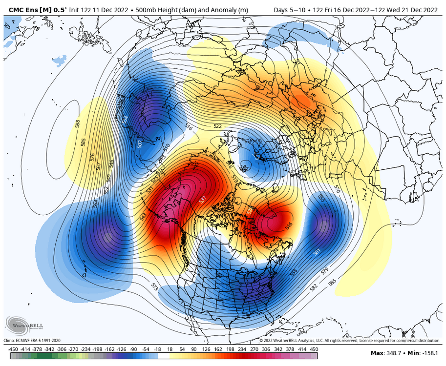
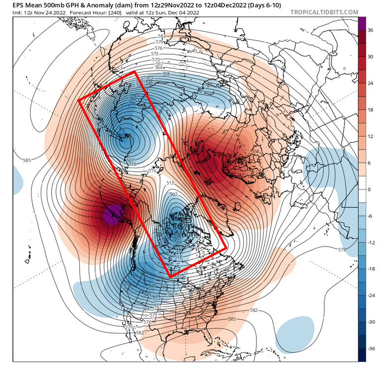
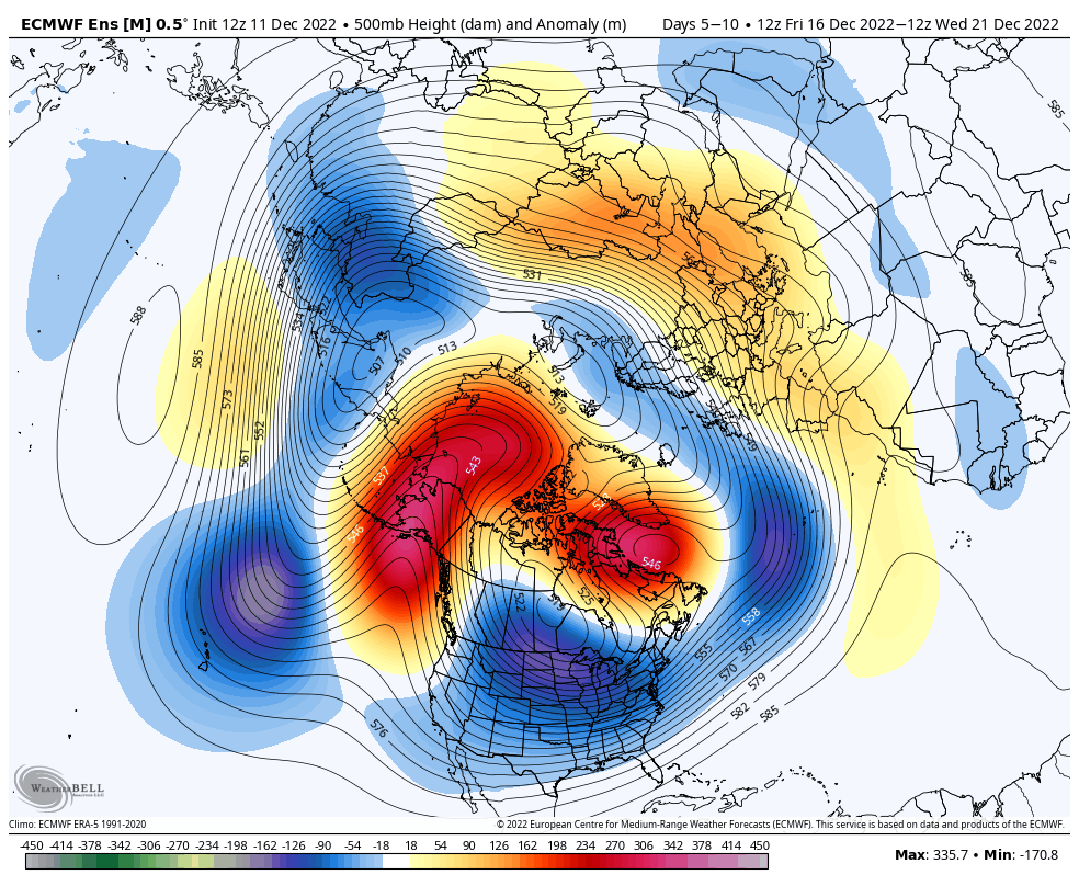
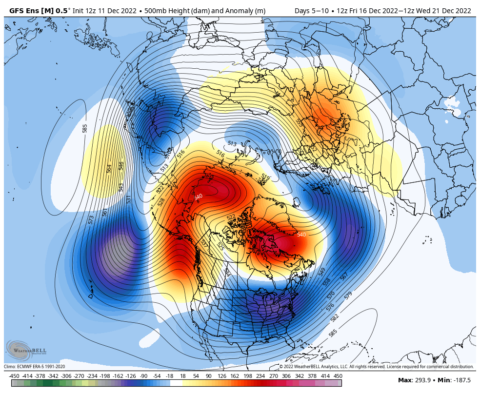
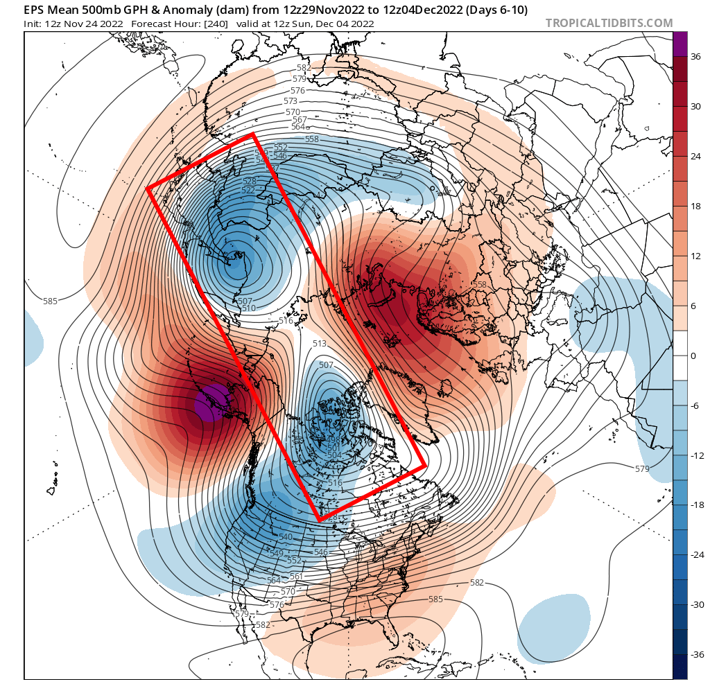
Pretty incredible agreement on an extreme 5-day mean pattern on all 3 ensembles 5-10 days out (December 16-21)...and this point, that's unlikely to significantly change: Euro ensemble: GFS ensemble: Canadian ensemble: All three have a huge ridge over the northeast Pacific and Alaska extending to the north pole, facilitating prolonged and robust cross-polar flow. Plus, a west-based -NAO persists. Sub-tropical jet looks fairly active, thanks to a ton of momentum getting added to the Pacific jet stream over the next week or so (this also contributes to the huge ridge into Alaska). Suppression is a concern, but this is definitely a robust clipper pattern too with such amplified flow out of Canada. And, if we can get sufficient wave spacing and a shortwave can amplify, the blocking does support amplified, slow-moving systems across the central and eastern CONUS...but again, would need proper wave spacing or else we'll get more numerous but more suppressed systems in the sub-tropical jet. Because this is a La Nina there will be a gradient with frequent systems somewhere, likely south of the entire region at times, but when blocking relaxes or if a stronger shortwave in the subtropical jet comes along it could shift north at times. Regardless of how much it does or doesn't snow, much of the CONUS will be cold to very cold in the lead-up to and then through the holidays. Severe cold will pour into the northern Rockies and Plains at times, with large pieces of that coming east. Really is hard to draw up a better pattern for Arctic air outbreaks, and at least some snow potential appears to exist. A couple important things happening teleconnection wise in the near future...first, a huge Siberian high descends into eastern Asia later this week. A strong "positive" east Asian mountain torque, which will add significantly to the Pacific jet stream: Note how shortly after the huge high descends out of Siberia, the Rossby wave train amplifies significantly over the Pacific, allowing the huge ridge to pop into Alaska. It does not hurt that the MJO is becoming more coherent and moving into the western Pacific after mid-December: This also adds to the Pacific jet...looking at the op Euro, note how early on in the loop there's some enhancement to the Pacific jet from the first little high descending over East Asia. This begins amping ridging towards Alaska. Then, the larger high descends and convection increases over the western Pacific, adding a ton of momentum to the jet and causing the ridge to amplify in a huge way over the eastern Pacific: Long story short, the north Pacific ridge has had a propensity to amplify this fall and is about to do so in its most significant fashion yet over the next 5-10 days...this will lead to a pattern very supportive of extreme cold into the northern Rockies and Plains, with cold anomalies dominating most of the CONUS before and during the holidays. Snow potential will inevitably come and it's possible the sub-tropical jet has some activity, but some uncertainty lingers regarding more significant snowstorm potential.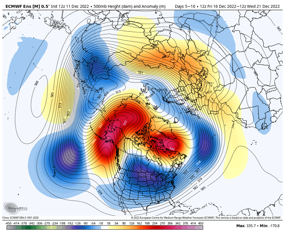


- 815 replies
-
- 15
-

-

-
Some Thoughts On The Next Couple Months
OHweather replied to OHweather's topic in Weather Forecasting and Discussion
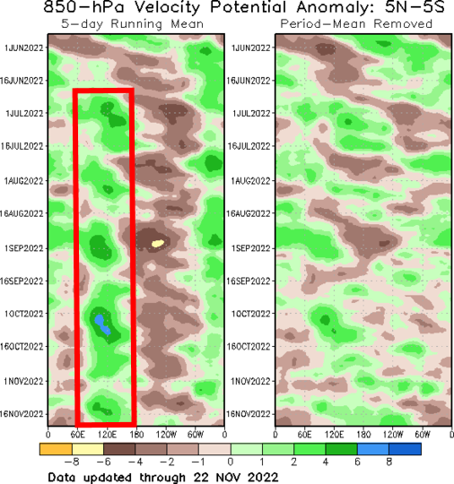
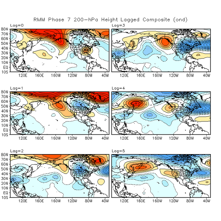
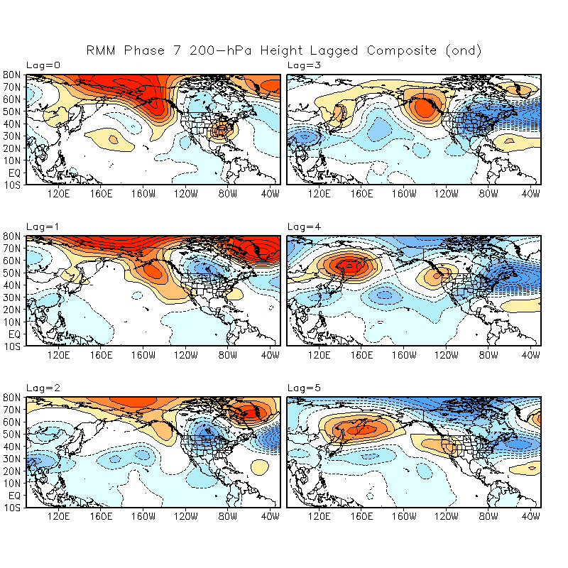
Definitely a good call on the late November warm up...suspected we'd get a milder spell, but for a week or so the CONUS will be very mild. Looking into December, I still remain quite intrigued...agree with Matt that I feel like we may be getting somewhere with the pattern pretty soon. the ensembles are increasingly keying on a pattern featuring a -EPO and -NAO into the first half of December, though with an initially -PNA. This would support colder air pressing back into the CONUS starting early next week out west after a relatively brief hiatus (on the broader, national scale). With an initially -PNA the cold air will first focus out west with mild weather over the eastern U.S., though a persistent -EPO and eventual -NAO could change that. Ok, time for some loops: So to start, the pattern early in the loop is a mild one across the CONUS. There’s troughing over Alaska (a positive East Pacific Oscillation/EPO) that’s flooding much of the CONUS with milder air after our impressive mid-November chill. With a -PNA (Aleutian ridge/west coast trough) any limited cooler air is going into the western U.S. right now. But, focus on Scandinavia (northwestern Europe). A persistent Scandinavian block has been ongoing and is progged to amplify this week. First, it sends a blast of cold air into Siberia and the rest of eastern Asia, a key to changing the Pacific pattern. Then, the block is shown on the European ensemble mean to retrograde towards Greenland, causing a negative NAO to develop through early December. This Scandinavian ridge/block has been persistently modeled for a couple of weeks, which is impressive…and it’s also a pretty important piece to the puzzle. The set-up, as everything is currently modeled, seems to support both a -EPO and -NAO developing through the first half of December. The blast of cold air into eastern Asia sends strong high pressure down the eastern side of the Himalayas, in contrast to the current low pressure over eastern Asia. Low pressure lowers the resistance against the planet’s rotation east of these tall mountains, allowing the planet’s rotation to speed up ever so slightly. To conserve angular momentum, the Asian-Pacific jet slows down and retracts. This favors anomalous ridging over the northwestern Pacific and low pressure over western North America…not a cold pattern for the Lower 48. Fast forward to later this week and beyond, when high pressure drops in east of the Himalayas and does the opposite, speeding up and extending the Asian-Pacific jet. This favors lower pressure over the northwest Pacific in the exit region of the jet and pushes the ridge east, while the added momentum into the Pacific jet amplifies that Rossby wave train. Low pressure over western North America is replaced by high pressure descending out of the high latitudes. It’s a much colder pattern for most of the CONUS, though the East Coast will be the last place to consistently get the cold. Also note how Rocky mountain torque is demonstrably important. Early in the loop, high pressure east of the Rockies is in place, which favors intensifying/extending the jet over eastern North America and into the northern Atlantic. This favors low pressure over the North Atlantic in the left exit region and a +NAO. However, a series of low pressure systems developing east of the Rockies in the middle portion of the loop does the opposite, retracting the jet and giving the Scandinavian block room to retrograde. To best illustrate, here's the 250mb wind loop: Early in the loop, the jet streak is breaking near the coast of East Asia and the north Pacific ridge is well to the west. As the jet extends in response to the East Asian Mountain Torque, that ridge is pushed east, a pattern much more conducive for pressing cold air into Canada and towards the continental U.S…also check out the Atlantic. Initially, the jet is roaring off the East Coast, but as low pressures develop east of the Rocky mountains and cause a negative mountain torque, the jet pulls back and allows ridging to retrograde over the North Atlantic. This causes the NAO to trend negatively, and is more conducive to troughing over the eastern U.S. Another way to visualize this chain reaction…cold dumps into eastern Asia. Alaska then goes from cold to mild. Cold air then begins pressing into the CONUS. As ridging retrogrades over the North Atlantic and cold continues to funnel into the west, increasing pressure is put on the Southeast ridge and the eastern U.S. gradually sees cooldowns. Probably a very up and down pattern in the east, and leaning much colder west. In general, as the highest latitudes warm, the mid latitudes cool. The MJO is moving into Phase 7 at a high latitude for the second time this month, and it could end up squeaking into 8: Convection has been favoring the eastern Indian Ocean/western Pacific all summer and fall, a classic more “eastern based” La Nina response: In the late fall/early winter, a phase 7 MJO is typically followed by ridging near Alaska and Greenland, a -EPO and -NAO respectively, with cold first dropping into the west and then spilling east. We are approaching Lag=0 now and will be Lag=1 and 2 next week into the following week (each lag is 5 days): Lots of stuff pointing to a -EPO and -NAO and resulting colder pattern over the CONUS and slightly thereafter Europe as well…though don’t overlook the initial -PNA and Southeast Ridge causing cold to go into the western U.S. first. Can this return to cold through early December bust? As always with a longer range forecast, yes. My main concern is where the tropospheric polar vortex ends up, and if it splits as quickly as modeled over the next 7-10 days: In particular, my concern is where the lobe over northeast Asia ends up. If it ends up dropping a bit farther east, it could mute any ridging into Alaska. I feel that’s on the less likely side, but it’s slightly precarious. If we see the tropospheric polar vortex split like the ensembles currently show, with one lobe into Siberia and another into northern Canada it bodes towards the colder outcome being favored over North America in December.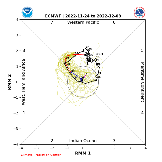
-
Winter 2022/23 Lake Effect Snow Thread
OHweather replied to Chicago Storm's topic in Lakes/Ohio Valley
In Novi, MI right now and the squall the just hit pounded. Quick inch inch and a half in less than half an hour. -
Upper deck tickets were less than $20! Figured it was worth it, going up this evening and making half a weekend out of it. I think that is a plausible scenario...the winds over the lake turn 90 degrees in 6 hours tonight, I feel like we're going to see that burst push through the lakeshore quickly. It will be heavy, but I'm not sure if it can add up more than a quick couple inches right near the water.
-
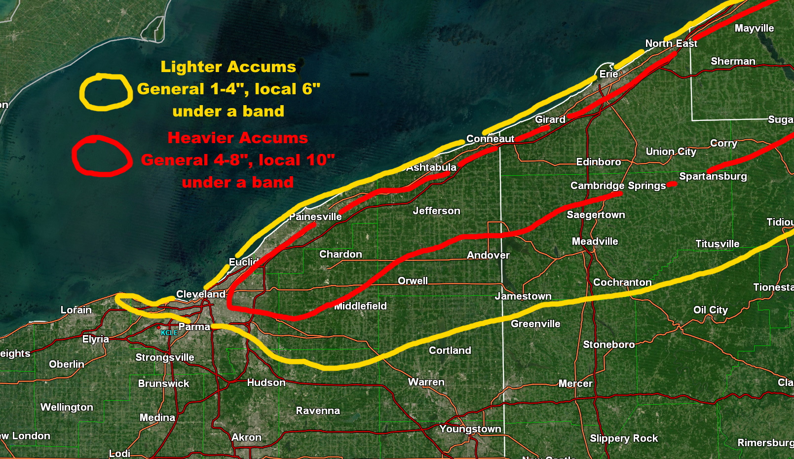
Still looks like a very intense burst of snow pushes onshore into most of the primary snowbelt late this evening with the cold frontal passage. However, winds come around quickly so the burst will be transient, with WNW flow bands setting up behind it. Still a short duration event, with ridging building in midday Sunday and beyond, significantly weakening bands and shifting them back northeast again quickly through the afternoon. Between the synoptic moisture/support with the cold front, apparent connection to southern Lake Michigan, and crazy instability, parameters are very favorable for heavy snow late this evening through early Sunday. Conditions quickly decline on Sunday, though bands can probably still produce localized moderate to heavy rates through the morning before losing more punch by the afternoon. It will also be windy and the snow will be very fluffy, so it'll blow around. In terms of accums and the warnings, given the short duration of the event and transient bands I do worry that many areas will struggle to quite get to the forecast snow amounts. I do think where those WNW flow bands set-up for several hours later tonight into Sunday morning can get to the forecast, as rates of 1-2" per hour are likely through early Sunday under more organized bands, however those bands will not impact the whole area so those higher totals will be localized...otherwise, probably a general spray of light to moderate accums from the burst along the front followed by the lingering snow showers outside any bands. There is good model consensus that one band with a Lake Michigan connection sets up from somewhere in northern or northeastern Cuyahoga County into Geauga and perhaps far southern Lake, and that may be where some of the heaviest totals occur. Otherwise, we often see a couple other bands set-up in this type of flow from parts of Ashtabula County east across Erie County. Here is a very rough representation of the totals I'm loosely thinking of: A big question mark is where that westernmost band sets up...winds briefly come around to 285 or 290 for a few hours early Sunday, which could get it into a good portion of Cuyahoga and even northern Summit/Portage, but it will have an upstream connection to Lake Michigan and we've seen those types of bands get stuck up closer to Euclid or Mayfield before. Otherwise, I think the rest of the inland core snowbelt gets marginal warning criteria amounts with locally heavier amounts under a couple of persistent bands, with advisory amounts surrounding that. I think the warnings as they are were probably all needed, though I could quibble about the Ashtabula and Erie lakeshore zones maybe being more advisory-worthy I suppose. Cuyahoga has some bust potential, but that western band may be the most dominant and the vast majority of indications are it at least gets into the eastern suburbs, so I think there wasn't much choice but to warn Cuyahoga. I was talked into going up to Detroit later today through the game tomorrow, so I will not be home for this...I guess I'll see if there's any snow on the ground when I get back tomorrow evening.

-
Winter 2022/23 Lake Effect Snow Thread
OHweather replied to Chicago Storm's topic in Lakes/Ohio Valley
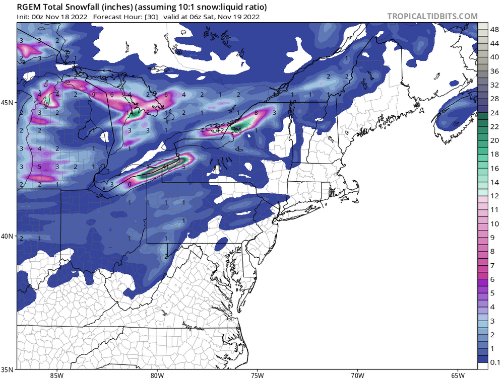
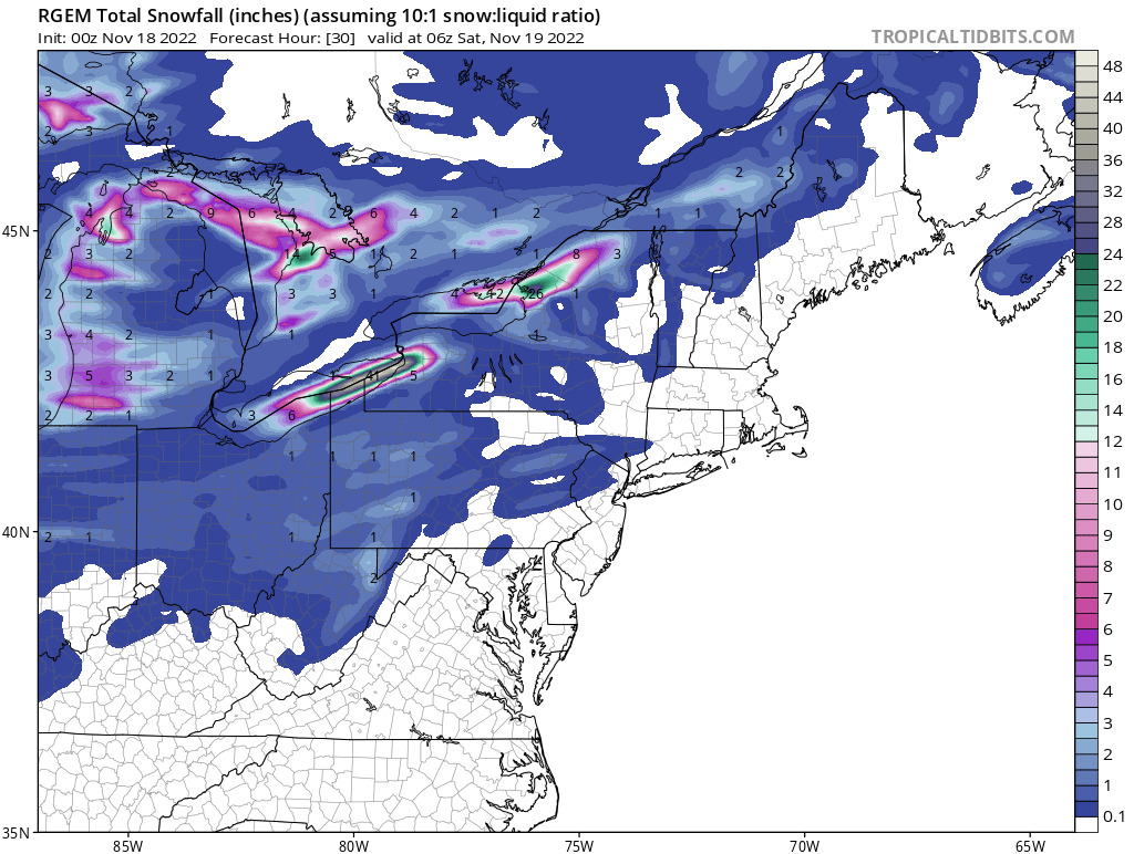
The HRRR also gets a gold star for its performance in Ashtabula County OH (northeast corner of the state) and Erie PA this last evening...its runs the night before had up to half an inch of QPF in Ashtabula (they got 2-4") and up to 1" of QPF in Erie County PA (they got up to 8")...the QPF was overdone, but it was sniffing something out. That said, subsequent runs showed almost 1.50" of QPF on top of Erie, that was a little overzealous. 0z HREF PMM slightly too snowy, but got the idea right: The 0z Friday RGEM kept it out over the lake, a swing and a miss... As for the rest of this weekend, the progressive nature of the trough leads to a short lived set-up with shifting winds spreading totals out, but on the plus side, the sharpness of the upper-level trough and origins from over Siberia (see loop below) will encourage very intense squalls off the mild November lakes along with gusty winds. A lack of band persistence/longevity will be a limiting factor overall, but if any persistent bands or upstream connections develop heavy rates would allow snow to quickly add up on a highly localized basis..thumb.png.62a5ac6c24a694cf890af324d5f5f7bf.png)
.thumb.gif.bdf1f7f8ff0565c340a9e66a4cdf7845.gif)
.gif.95d1cabc5751c96661117789a04d9174.gif)
.gif.bfa69bb02ffc7f8b00d0c09040ff9ced.gif)
.gif.2b6501444d90642f04b9c3eb375368f6.gif)
.gif.0c76347ce92bc5f5d0a77fd9226e8211.gif)


.png.f04d7e0f39dbfb13a029e5b5c66df65a.png)
.gif.d74a475201f887b451ab7ed1ec1e9fe9.gif)