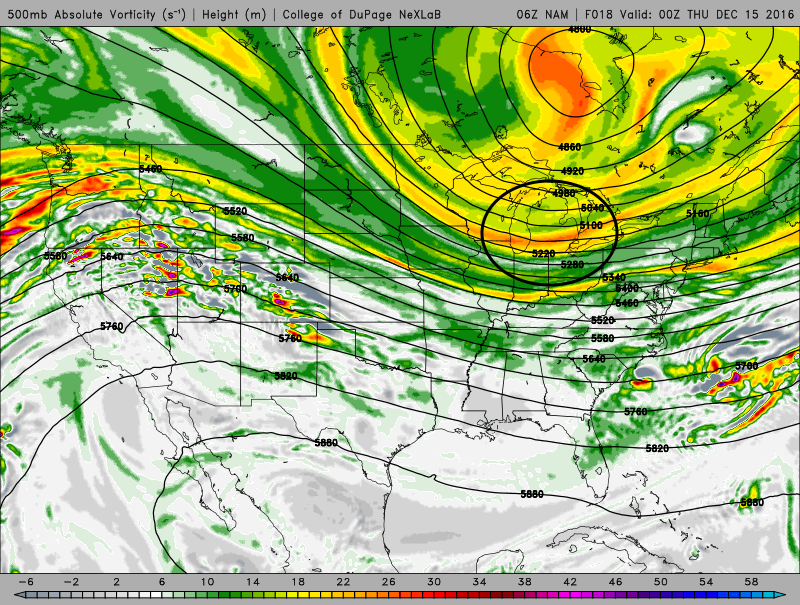
An unseasonably deep upper level trough will drop into Ontario and Quebec through Friday, ushering in the coldest air of the season thus far and aligning the winds out of the west-northwest across the Great Lakes, setting off another round of heavy lake effect snow.
Lake effect snow will intensify this afternoon as winds go southwesterly and allow a strong single band to form over the lake towards Buffalo. The flow is somewhat sheared, however an increase in moisture and lift ahead of a shortwave rotating around the upper level trough and moderate instability developing over the lake should allow snow rates of over 1” per hour to develop with the band as it moves off the eastern end of the lake this afternoon into locations near and just south of Buffalo.
The aforementioned shortwave will move over Lake Erie and NE Ohio/NW PA/SW NY between 0z-6z/7pm-1am Wednesday evening and push winds to a more WNW direction. As this shortwave approaches, even colder arctic air will move in allowing instability to decrease, while at the same time inversion heights come up. A connection to Lake Michigan will likely develop and larger scale lift from this first shortwave and another one will help enhance lake effect processes Wednesday evening through Thursday morning.
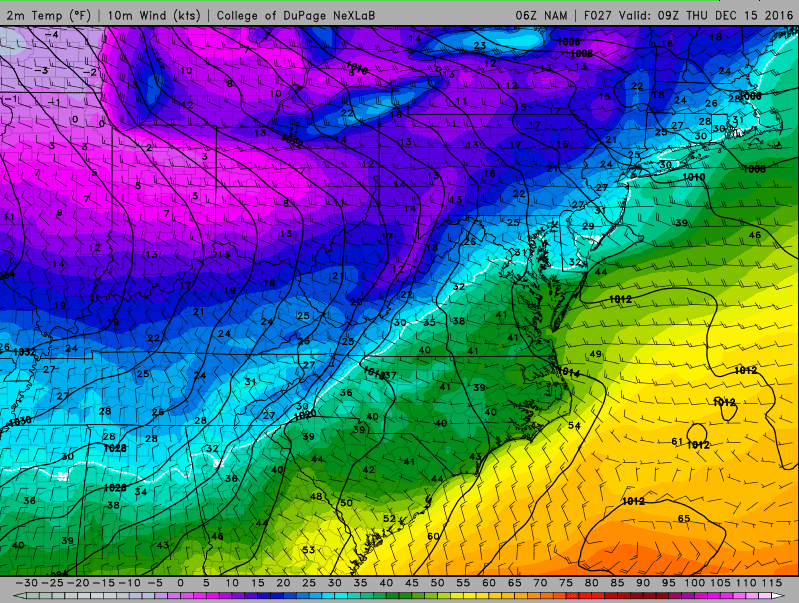
Instability will increase this evening, with lake to 850mb temp differentials increasing to 22C+, lake to 700mb temp differentials increasing to 32C+, and lake to 500mb temp differentials increasing to 40-42C. These values are all extreme and along with equilibrium levels on the models of over 10k feet suggest any snow band will be very intense and likely accompanied by some sporadic lighting. The combination of some moisture from the shortwave trough and a connection to southern Lake Michigan will increase moisture depth to around 8k feet. Snow ratios should be fantastic tonight with good RH and strong lift focused on the DGZ. Winds are a little bit on the strong side, but a very well aligned flow, upstream connections, and a favorable long fetch with a W to WNW flow and good convergence along the shoreline should mitigate the stronger winds.
The first trough this evening doesn’t have appear to enough oomph to push inland, so the band may get locked in or move very little for several hours late this evening into early Thursday morning. With rising pressure over the Ohio Valley and very cold, dry air inland along with WSW winds, this band will likely setup near or along the lakeshore and into the primary Snowbelt. This wind profile is fairly similar to the one that locked in a band along route 6 with the last event, although with somewhat stronger WNW winds over water, which may allow the band to set up a couple of miles farther south tonight. This could bring downtown Cleveland, the immediate western lakeshore, more of eastern Cuyahoga County and more of southern Geauga County into play tonight. I don’t expect a huge difference in placement from the last event, but that couple of miles could make a big difference to some heavily populated areas that were on the edge of the last event. The winds wiggle a little bit between late this evening and Thursday morning, but not a ton, so the convergence near the lakeshore and fairly steady winds should cause the band to drift over similar areas for most of the night tonight.
The next shortwave and surface trough will push SE across the lake between 5am and 10am Thursday morning. There appears to be a somewhat stronger push of NW winds behind this trough, so it will likely push the snow band inland before perhaps breaking it up into multi-bands for a time later Thursday morning.
The environment will be very favorable for heavy lake effect snow as this second trough passes; wind shear will be minimal, although wind speeds again are maybe 5-10 knots faster than is preferable. Lake to 850mb temp differentials are expected to exceed 25C by Thursday morning, with 700mb differentials exceeding 35C. These are both incredible differentials driven by the arctic airmass moving over a still somewhat warmer than average lake, with lift from the shortwave and an upstream connection to Lake Michigan offsetting the drier arctic airmass.
The trough will likely push through quickly enough that the band doesn’t sit on any one spot for more than a couple hours (although we’ll have to watch and make sure it doesn’t get hung up just inland), however the instability/moisture profile combined with the minimal wind shear, strong lift and good RH in the DGZ, and very strong convergence expected between 10kt WSW winds south of the trough and 30kt WNW to NW winds over the water north of the trough, suggests that very heavy snowfall is expected. Instantaneous snowfall rates to 2 to 4” per hours seem likely should this band come to fruition, however it’s questionable how long these rates sit over any one spot. The bad news is this band looks to move across a good portion of the Cleveland metro near rush hour, and even if those snow rates don’t last long they can create quite a mess.
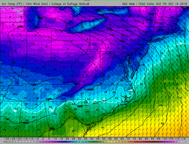
Behind the trough Thursday morning, winds are expected to go WNW to even NW, and this should push the primary band inland and break it up into multi-bands for at least a few hours. This will likely spread some lighter accumulations into the secondary Snowbelt and give a break to the northern primary Snowbelt. This flow could bring upper Great Lake connections (perhaps Superior/Michigan) into NW PA, and also hits the upslope areas well there, so moderate accumulations could continue in NW PA behind this trough in the higher terrain, with activity tapering considerable near and north of I-90. The Lake Michigan connection should shift south of Lake Erie for a few hours later Thursday morning and early afternoon in the more WNW to NW flow, although it’s possible upslope in the central highlands allows for a period of snow showers as the Lake Michigan connection aims towards that general area.
Some negatives will develop behind this second trough; the fetch will become shorter and the airmass will dry out, both due to the upstream airmass becoming even drier and the Lake Michigan connection shifting south. This drier airmass, shorter fetch, and somewhat colder temperatures will likely make it hard for intense bands to develop. Outside of any intense bands, it will be cold enough to limit snow growth and hence keep ratios in check. So, accumulations could really slow down for a time later Thursday morning into the afternoon. If a heavier multi-band can set up, then latent heat release within the band may push the DGZ into the clouds and allow for locally higher ratios within any band; due to the flow though it may be a struggle to see good bands develop for a time on Thursday.
The surface high will really start pushing in Thursday evening, allowing temps to crater over land to near 0 and also causing SWrly winds to develop on land. This will tighten up convergence again near the lakeshore and in the Snowbelt, and may also re-develop a Lake Michigan connection for a time:
This combination of renewed convergence and some improved low level moisture could allow a band to re-develop from northern Cuyahoga County east into southern Lake and Geauga Counties Thursday evening. Winds will slowly continue to back as high pressure noses in, so this should cause the band to slowly shift northeast through the night. With that said, the winds on land may not get strong enough to push the band completely over the lake until Friday morning.
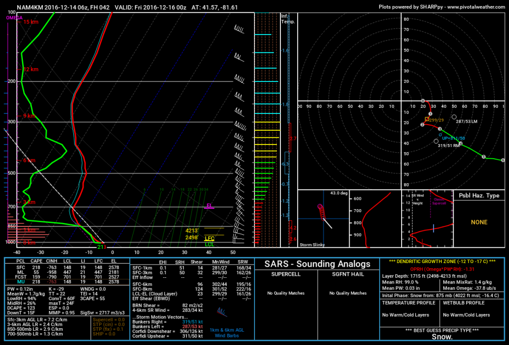
Forecast soundings from within the potential snow band on hi-res models show inversion heights remaining near 700mb through Thursday evening before really dropping off, with good moisture and lift (omega) in the DGZ. This could allow a decent band to still produce 1-2” per hour snow rates for a time Thursday evening closer to the lake. With that said, inversions do crash later Thursday night and high pressure will try pushing the band north, so amounts Thursday night will likely be held to less than 6” where the band is more persistent, and much of that could fall during the first half of the night.
So, as for amounts…it is quite possible that the lakeshore from eastern Lake County east through Erie County struggle to see a ton with this one. I expect a good burst in the primary Snowbelt from northern Cuyahoga County east/north as the single band pushes onshore with the first trough tonight. With convergence quite possibly hanging close to the lake and into the Snowbelt tonight behind the first trough, along with a Lake Michigan connection and very favorable conditions for heavy lake effect snow, it seems possible that a heavy band with 1-2” per hour snow rates persists for several hours tonight. With WNW winds over water, it is possible this band affects the lakeshore in Cuyahoga County before moving inland into the eastern suburbs, southern Lake County and a good portion of Geauga County. With a long fetch into the higher terrain of NW PA, those areas may do decently too. The band may wiggle some, which if it occurred may keep amounts through 5AM Thursday in the 4-8” neighborhood where the band affects most…however, if the strong convergence causes the band to be more impervious to small wind direction changes, the band locking in and producing up to a foot by 5AM Thursday isn’t impossible in a small area.
I expect the snow to intensify across the board between 5-9AM Thursday as the next trough passes through. Snow rates could increase to 2-4” per hour in the dominant band. This band will probably initially intensify in the northern Snowbelt before slipping south through 9AM Thursday and quite possibly breaking up into multi-bands late Thursday morning as the winds go WNW to NW. This band may move quickly enough that it only drops 1 to 4” of snow as it goes, but this could affect parts of Lorain, much of Cuyahoga, southern Lake, much of Geauga, southern Ashtabula, parts of NW PA (inland especially), and perhaps even northern Medina, Summit, Portage, and Trumbull with a burst of very heavy snow during rush hour. This could be a very high impact event. If the band gets hung up somewhere at all, even for just 2 or 3 hours, the very heavy snow rates could allow it to quickly drop over half a foot over a narrow corridor. This may happen from the western lakeshore into SE Cuyahoga County for a time, due to the winds paralleling the shoreline there for a time and perhaps causing the convergence to “stick” to the lakeshore for a couple of hours.
The snow should diminish across the board late Thursday morning and into the afternoon. The instability suggests heavy squalls may still occur, but the snow bands will likely break up by then, and the colder/drier arctic air may stunt snow growth outside of any good bands. Some areas, such as the higher terrain in the secondary Snowbelt, Geauga County, and particularly NW PA may pick up 1-2” late Thursday morning and afternoon, but unless we get a band to hang on from the west side into say Medina/Summit Counties…which does sometimes occur with this type of flow, but is hard to predict ahead of time…I doubt accumulations will be particularly impressive in this timeframe.
Signs do point towards a single band re-developing late Thursday afternoon and into the evening as winds inland turn SW and increase convergence along the lakeshore into the Snowbelt, while a potential Lake Michigan connection also tries to redevelop. Inversion heights will start to lower and moisture will be more limited than say tonight, however intensifying convergence along with weakening winds (increased residence time over the lake) could still allow a decent band to develop for a time. This band may initially develop from the western lakeshore out east towards Chagrin or Solon before gradually moving north. Snow rates of 1” per hour or more may still be supported Thursday late afternoon and evening if we get a good band to develop, but the band will likely be slowly moving, and conditions appear to degrade significantly for lake effect after midnight, so additional amounts from this band will likely be held to 2 to locally 6”.
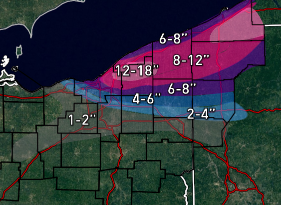
Storm totals may exceed a foot where the band is most persistent tonight into early Thursday, and where the snow band tomorrow evening affects. I doubt amounts exceed 18” due to the bands likely moving around/breaking up at times through the event. I did include decent accumulations on the western lakeshore, as convergence could be strong in that area at times and allow for banding there. The southwest edge is as always not high confidence.
Map:
Also, I know a couple of you asked me questions yesterday, when I get time today I will try to respond. Was not home until about midnight last night.