OHweather
-
Posts
4,957 -
Joined
-
Last visited
Content Type
Profiles
Blogs
Forums
American Weather
Media Demo
Store
Gallery
Everything posted by OHweather
-
I don’t disagree that the models have been horrible lately and they generally look less snowy as we get closer, it’s been the same here, but you’ve still gotten snow. It hasn’t been banner by any stretch and may not be meeting expectations for some, but it’s been “ok” with a lot of winter left. I suppose it’s been a few years since a truly good Ohio winter and we’re due for it, but weak El Niño’s are what they are for the Ohio Valley. Some have gone big but most don’t. If it still looks like crap in a week or two maybe it’s time to bring on Spring, but it is still early enough to get plenty of snow and then break for a decent spring by later March.
-
I’d argue the extended doesn’t look terrible...reshuffle in the pattern next week with 5-7 mild/snowless days and then it’s not even mid February with a -AO persisting. While a lot of your snow has come from unexciting events, that is literally climo for Ohio unfortunately and most of it has been recent. The storm two weekends ago was not an underperformer for central or southern or even northern Ohio. Many including myself got burned on how far north it rained last Saturday, but it was still a plowable snow and a lot of wind with the deform behind that. That’s two advisory to warning criteria snows on back to back weekends. It’s been wintry enough lately and there’s still a lot of time left. I just can’t find the will to feel bad for the Ohio crew after the last two weeks. I’d expect this sort of complaining from NYC or BOS where they’re at least significantly below average snowfall to this point, and tend to be more temperamental anyways.
-
I get that it hasn’t been a banner winter for many in Ohio and last weekend was unfortunate, but considering climo and how bad it was until two weeks ago...and how much time is left...it’s way too early to root on Spring IMO. It would be another thing if it was a month or month and a half later. I wouldn’t get excited for too much along the arctic front personally, if something can spin up ahead of that cold it’d be nice but seems like a long shot. But there’s still time after this week. The thing about a back loaded winter nowadays is everyone wants to cancel it before it gets a chance to be backloaded. It’s even worse in the Philly-NYC-Boston corridor where they’ve largely missed out the last two weeks (and Boston has been hilariously futile so far).
-
What am I missing? Isn’t most of central/southern Ohio near normal snowfall wise (some a little above, some a little below) with most of that falling in the last two weeks? The pattern also isn’t exactly warm coming up and it’s not even February 1 yet. It’s like reading a funeral in here because a surface low over toledo managed to bring sprinkles (it looks like the vast majority of your precip fell as snow with temps at or below feeezing north of Cincinnati and that maybe it briefly sprinkled). This wasn’t going to be more than an inch or so of snow anyways.
-
Yep. Unbelievable. I think the RGEM showed that though.
-
I still maintain that this, all around, has been one of the most frustrating storms I’ve had to forecast. The low is on the weaker side of pressure from what was modeled yesterday at this time but it’s just...warm. The deform band is very strong but has some holes as mentioned so may not blast everyone...but should bail some people out. This is a severe storm in northern OH where it’s been all snow. I’m still sweating the N NJ forecasts I made earlier today...last second indications are the southern edge may do a bit better here. Though I’ll hopefully be sleeping when it gets here.
-
I think with the last second amped trend and backend lake effect many of your will push or exceed a foot.
-
Someone’s going to be very unhappy. Sorry for the false optimism yesterday! Hopefully the deformation band still dumps on some of you. What a f*ckin storm. I’m beyond done with it.
-
I don’t personally know him but also follow him on Twitter. Hopefully you guys get plenty of snow!
-
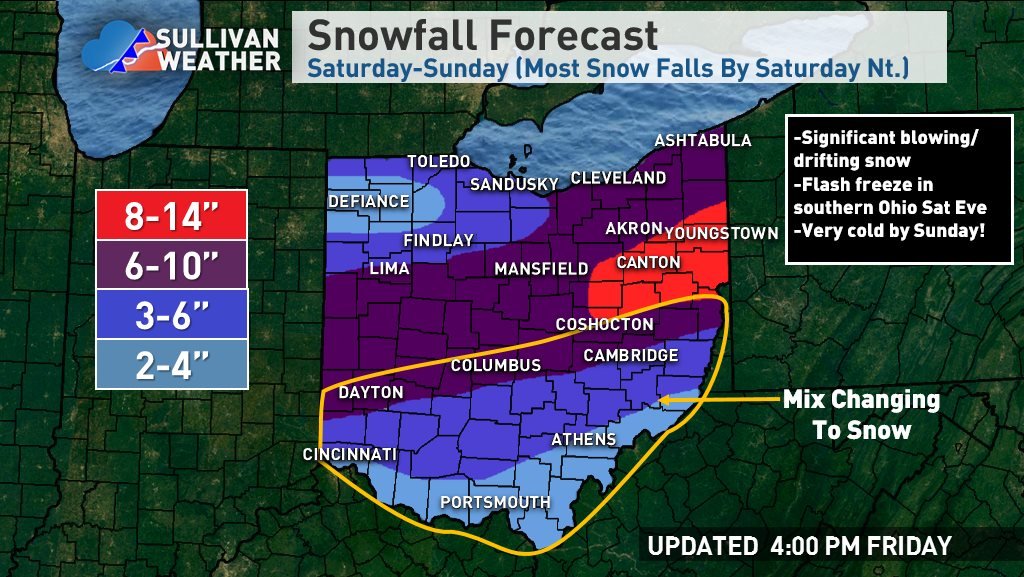
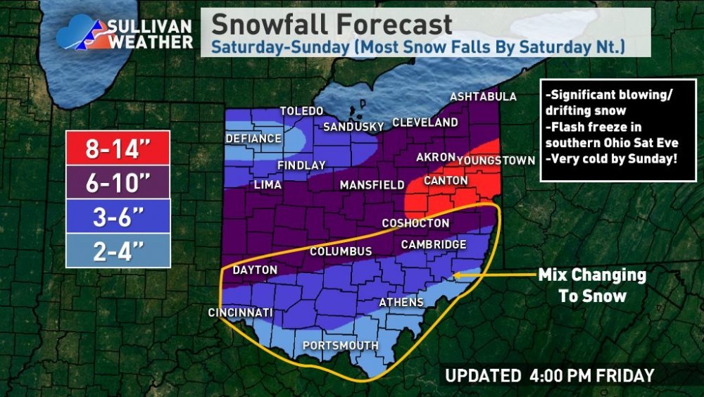
That looks a lot like a Crankywx graphic ^ For NE OH ended up going with a broad 6-10" area. I think the heaviest snow does stay south both with the warm air advection push during the late morning and afternoon and with the evening deform...but, a prolonged period of favorable jet dynamics and isentropic lift causing upward motion in the dendrite growth zone should yield a prolonged period of light to occasionally moderate snow with good ratios. With modest lake effect on the back side through Sunday evening feel 6-10" is easily doable. If the evening deform band can trend a bit farther north can see how spots see over 10" farther north, but my current hunch is that doesn't happen...worth watching though. The WAA snow largely goes south of NW OH so expect lower amounts there.
-
It will likely get going over Indiana mid to late afternoon.
-
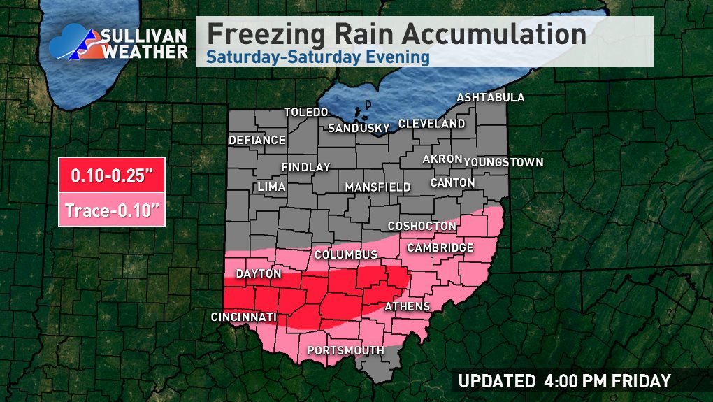
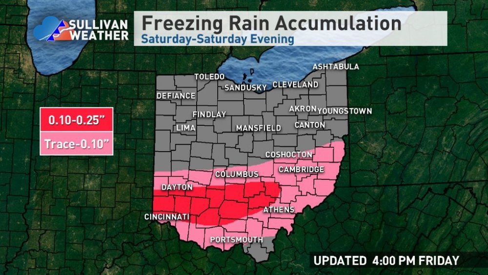
Given the aforementioned trend today for slightly lower heights ahead of the storm, allowing for a bit more cold air in front of it (and the likely under-modeling of low-level cold air seeping south) and the trend for a bit more amped/slightly slower vort (undoing some of the negative trends from yesterday) have made changes to my forecast. The trend for slightly colder air ahead of the storm makes sense given how intense that lobe of the PV is, and the trend for a slightly more amped storm as we approach is typical. Wouldn't surprise me if the GFS and CMC are still a bit too amped, but the Euro and UK have been rock-solid with their depictions and seem to offer a nice middle ground. The Euro has once again been the seemingly most consistent model over the last 2-3 days, so we'll see if its forecasts pan out. In terms of mixing/ice, the 850mb low track looks to be from about Cincinnati to Zanesville, however, the 700mb low track is well north of the region and there is a modest warm push as high as 700mb, so mixing likely does occur north of the 850mb low track for a time. This would bring mixing north of I-70. However, as the low wraps up during the afternoon and 850mb winds turn more E/NE the rain/snow line should shift back south of I-70. This likely cuts into Columbus's totals some, but it's not as bad as it could be. South of I-70 where the warm layer aloft will be deep enough for freezing rain instead of sleet, I'm pretty worried about a period of ice accretion. With brisk NE winds advecting in cool/dry low-level air, am not sure temperatures quickly shoot above freezing in this area as some models show. It will be kind of marginal for good accretion with heavy precip and borderline temperatures but given a good amount of precip falling as freezing rain in a narrow corridor can't rule out a tenth or two of accretion mainly in parts of SW OH north of the river and south of I-70. As winds pick up Saturday evening that could be problematic. As for snow amounts/placement, strongest mid-level forcing will generally be in central and southern Ohio, though a prolonged favorable dual jet structure and mid-level isentropic lift will allow for an extended period of light to moderate snow in northern Ohio that adds up to a few/several inches with some lake effect snow through Sunday from Mansfield points east. Two better periods of snow potential...one mid-morning through the afternoon on a push of strong mid-level warm-air advection/isentropic lift beneath the aforementioned upper-jet support and persistent PVA ahead of the shortwave. There is probably a period in the late afternoon/early evening when the precip shield becomes ragged for a time before a deformation band develops to the SW and moves through. The slowed nature of the storm on today's models increases the potential for this deform band to affect a good portion of Ohio outside of NW Ohio. The heaviest snow from the deform band looks to be from SW OH to central to east-central Ohio points east. The deformation band may be intense as models show intense mid-level frontogenesis on the backside of the storm as arctic air crashes in and deformation, along with strong PVA from the vort max and steepening lapse rates. The snow could be convective and the lapse rates may be steep enough for thundersnow. Snow rates of 1-2" per hour are likely. This feature is rather transient but can drop a fair amount in a short period of time. Essentially, given the lower heights ahead of the storm forcing a trough along/just south of the Ohio River did shift the heaviest axis outside of far northern Ohio. The area that will do best is the area that can cash in on both the morning-afternoon warm-air advection snow ahead of the storm (where it's mainly/all snow and not ice/rain) and that can get in on the heaviest evening deformation snows. Much of the I-70 corridor sees a mix for a portion of the first round but changes to snow and then gets something from the deform. Given both rounds (especially the deform) likely feature moderate to heavy rates, did shift 6-10" south to include Columbus and Dayton. East-central Ohio may see more WAA precip fall as snow and also gets in on the deform, so believed the model consensus of heavier amounts in that area. I can see how someone farther west sees 10 or 12" too if the snow/ice line can set up a little farther south, perhaps between Dayton and Columbus, but not sure on that. Far southern Ohio will get hit decently by the deform band and I believe it'll be heavy, so went with decent snows all the way through. The flash freeze combined with a period of moderate to heavy snow and gusty winds will make for nasty travel in that area Saturday night.
-
Ugh
-
In terms of this upcoming storm for OH, can't really imagine better trends across the board today. Slightly lower height in front of the storm due to a little bit more cold seeping in from the north, but also a slower, sharper southern shortwave on every model except for the NAM. The NAM is still a bit of red flag, but the trend in general supports the snow/mix line setting up a little farther south and also more QPF.
-
I liked the cold idea yesterday and bailed on it today...regretting it at the moment! What's good is this also bumped up my totals a few hundred miles east too.
-
Had the brief thought a couple of years ago...due to various reasons went with the much safer option of just working for a well-established company instead. Certainly fun to think about though.
-
That's a lot like what the Euro's been trying to sell on the NAM...though a bit quicker so a little less QPF.
-
Yes. Can't complain about it coming out of college, and it's much easier to get into the private sector than say the NWS or broadcast.
-
Thanks...it'll be a fun/long weekend at work. Would certainly be less annoying if it was all snow. If we can rip off something cool here snow/ice wise I won't complain about the long week though. I'll hope for a colder trend for Ohio! (would probably help me too)
-
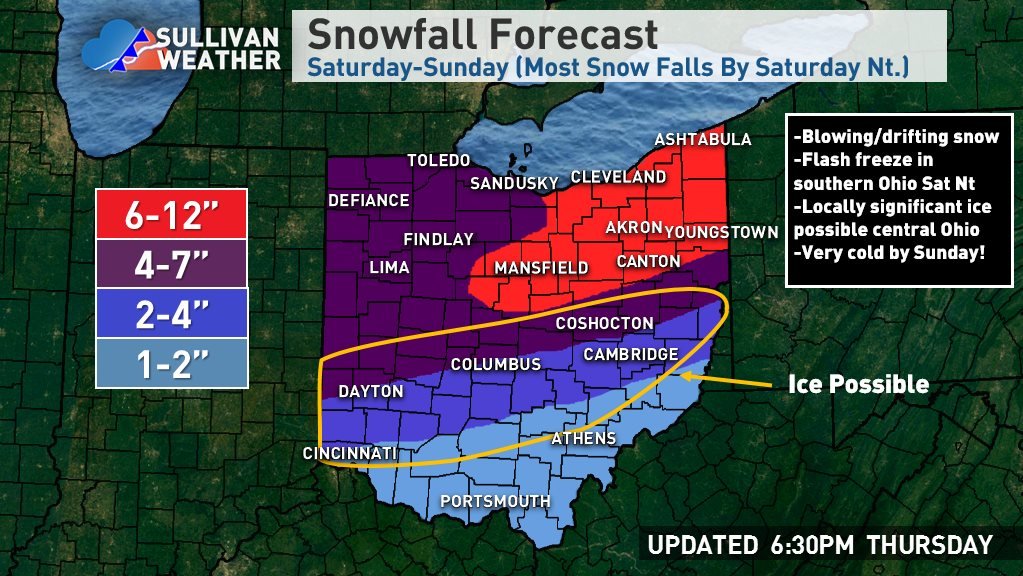
At this point going 6-12" for NE OH... The models have trended towards a sloppier/later phase and more progressive system, though the Euro/UK also came north some from their earlier runs due to less suppression from the PV lobe over Labrador/Newfoundland. This reduces the amount of QPF but does shift the axis north a bit. There will be a mid-level push of warmth into OH but right now all indications are that stays south of route 30 and probably closer to I-70 unless you're a big RGEM fan. Given the trend for a faster storm/less QPF overall, am holding off on any 12"+ totals for now...we will see if the progressive trend can stop soon. There will be enough lift for several hours of moderate to heavy snow on Saturday and that lift will be in the DGZ, so ratios will be decent. If the more amped NAM is right there's certainly potential for over a foot (the NAM probably supports a broad 15-20" this run), but again, the trend has been progressive so hedged under that but still a decent storm. The lake effect potential on the backside is less than stellar with a short fetch, strong-ish flow and dry air, but with some Lake Huron connection and good instability through the DGZ it could be enough to add another 1-3" wherever bands set up. All told feel a broad 6-12" is a good starting point...doubt it drops below 6", would take some work to go over 12" though stranger things have likely happened.

-
This storm has been extremely challenging for all of the areas I've had to worry about from MA/NH to NJ to OH, that's for sure. Here's my first map attempt for Ohio, may tweak tomorrow... The models are still struggling with the interaction between our storm and the lobe of the polar vortex swinging in from the Northwest, but, there have been some discernable trends over the last few cycles... -The lobe of the polar vortex over Labrador/Newfoundland has trended to lift northeast noticeably faster, allowing heights to rise more in front of the storm as it moves east -The southern shortwave has trended noticeably faster, which makes an earlier phase and hard cutter very unlikely. The low track will at worst be along the Ohio River. -The later phase/more progressive storm lowers the ceiling some in Ohio, and also limits the backside snow potential for areas that don't snow ahead of and during the storm. Although the Euro and UK still show significant snow well into central and even southern Ohio and the risk for a low track well into eastern Ohio has diminished since yesterday, the higher heights ahead of the storm kind of counteracts that and may allow for a stronger push of mid-level warmth. Due to that, I favored more ice/sleet along I-70 and lower snow totals. Given the strong high to the north with anomalous cold seeping south at the surface, there will almost certainly be a corridor of sleet/freezing rain, and it may be locally significant. I-70 is as usual on the diving line, so I can't rule out more snow if the UK and Euro are correct with their weaker push of mid-level warmth, but I'd hedge against that unless they hold and other models trend towards that idea. Some models are even warmer than what this forecast would imply though. There is 12"+ potential where it stays all snow, but until we get an idea on when the progressive trend will stop didn't want to pull the trigger.
-
I tend to think the 6z/18z runs being bad rule is over-emphasized once inside of a couple of days, but for some reason the "off hour" Euro runs have bumped north the last two days only for the next 12z or 0z run to come back south. The 6z Euro was a tick north but will be curious to see if the 12z holds.
-
This may be one of those rare setups where it inches a little colder closer in. The GFS put the "L" over KY, but has a pretty strong little surface circulation up to just NW of Wheeling, so I think that's why it pulls more warm air in. Canadian is north of the UK's low track and just misses crushing Columbus. The UK is a little more compact with the low. The 12z UK was rather snowy, will see if I can spot the 0z snow map floating around anywhere before I go to sleep. The GFS takes the 850mb low well northwest of its surface low track, a bit NW of Columbus to just south of Erie. The CMC looks a little bit more stacked. The 850mb low is a good indicator for how far north mid-level warmth will come and the GFS was a good bit farther NW, despite where it put the surface low. I ultimately don't like the GFS's surface depication at all, looks like it may be having convective feedback issues and it's known to be horrible with low-level temps.
-
UK met looks like it’d be a crush job for central/maybe southern OH. Crudely looking at the 24 hour plots it’s in the low 990s over KY and probably gets to near Charleston before transferring to off the Delmarva. The GFS and CMC did inch towards less phasing this run though the changes weren’t huge. Euro will be interesting...