

OHweather
-
Posts
4,957 -
Joined
-
Last visited
Content Type
Profiles
Blogs
Forums
American Weather
Media Demo
Store
Gallery
Everything posted by OHweather
-
This winter goes to show how much NE OH's snowfall climo depends on frequent light to moderate snows with an occasional prolonged lake effect/enhanced event. You guys pulled off your biggest synoptic storm since the 2010-11 winter, and are still way below normal. So different here on the east coast where some areas (especially NYC to BOS still) remain pretty far in the hole, but could get a chunk of that back with one storm. NE OH has a hard time making up ground without a rare big storm (either synoptic or LES) if they go a few weeks with little snow, which has happened several times this winter.
-
Yeah, the northern cutoff ended up being a bit abrupt. CLE reported a 1"/hr rate in the 7-8am hour but the radar has been more paltry for Lake/Geauga on east. Not a great northeast OH winter...
-
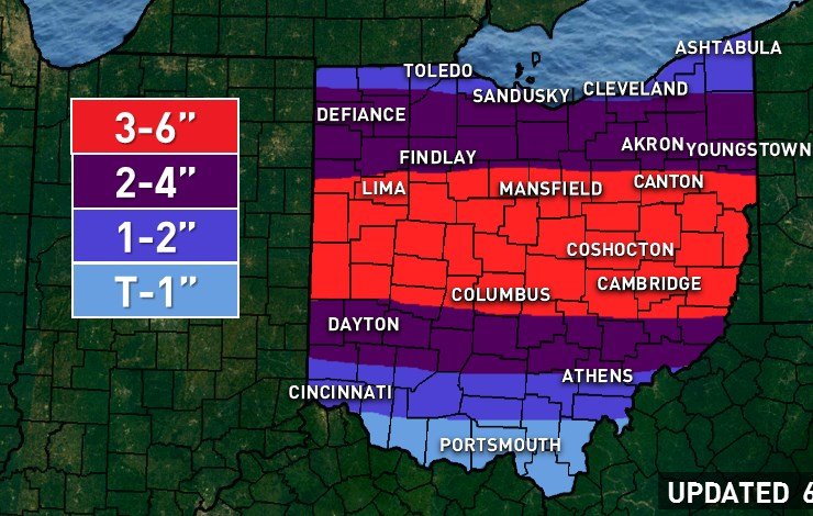
Looks like 3-5" panned out across Franklin County...Dayton was on a gradient with 4-5" north and probably 2" south. ILN's office got an inch of snow and almost a quarter inch of ice. The idea went well but I was probably 10 or 20 miles too generous with my 1-2 and 2-4" southern cutoffs...the 3-6" area seems to be going well. Too bad it happened so early in the morning, hard to beat thundersnow in terms of excitement. I've been at work since 3:30 AM which is why I've been so involved in the wee hours of the morning.
-
DAY reported another 2" last hour (4" on the ground, now mixing with freezing rain) and CMH reported 1" last hour (with 2" on the ground).
-
Big puffy balls of sleet I guess. It did sleet all the way up to Troy and then changed back to snow about as far south as the middle of Dayton when the thunderstorms moved in. The visibility also really dropped at the airport when that happened. You must've not been watching? Or are well south of KDAY? The sleet line is inching back north now so DAY likely goes back over to it before much longer. If it was really all sleet as you claim and they got 2" in an hour, that'd be even more nuts than if it was snow.
-
Maybe you're just north of Wright Pat. I've been checking ODOT cams it is snowing in/north of downtown Dayton. The CC line on radar is pretty accurate based on where you can see snow flakes on cameras.
-
You must be south of the airport. And yes, you count sleet as snow.
-
KDAY just reported 2" in the last hour and was mixing with freezing rain or sleet until 4:24AM! Nuts!
-
The convection is pushing the mixing line back south...Dayton is snowing again (KDAY reporting thunder snow!) and the Columbus airports are starting to flip again too...if you're struggling and along/north of 70 farther east should improve when the convection moves east.
-
Yeah, a good chunk has gotten into SW OH too the last half hour or so. The CC line on radar is trying to fight back near Dayton and Columbus, so we'll see if the dynamic cooling can happen. Mixing did get rather far north quickly with much of Columbus currently mixing... someone is going to get drilled and it'd be nice if it can be a majority of our central Ohio posters in this thread and not just the northern folks.
-
Dayton airport (which is N of downtown) reported 1" of snow last hour. Per the correlation coefficient (CC), the heavier precip moving into Cincinnati is attempting to flip things back for snow. For Cincinnati not sure if this ends up doing anything, but farther north along southern cutoff it might make a difference and was needed to get the southern edge of the heavier snow to work out. The precip moving WSW-ENE out of southern IN is convective and has some lightning, and is what would bring the heaviest rates to OH. I think Columbus hangs on long enough to see snow during this, but it's still close...much more certain a little north. A narrow portion of southern OH may do well with freezing rain as some stations have already gone to it south of route 50 and still have modest dry air advecting in...could see some spots crack 0.10" ice accumulation.
-
In terms of warnings it is debatable. There is no where near the required 80% confidence in 6”+ occurring in any given spot (even if it’s possible, it’s not that confident)...but based on impacts an argument could be made that several counties near I-70 particularly near/E/NE of Franklin could be upgraded on an impact based basis. Even that is a little flimsy as confidence still isn’t great, though at this point most signs are pointing towards that area getting hit reasonably hard for a few hours.
-
This should be a half decent thump of snow tomorrow morning (thinking 2-3" for Cleveland and increasing quickly to the south) as it keeps trending north/beefier...but as you guys brought up, it warms up and rains by tomorrow afternoon. Hopefully it's a scenic wet snow when it comes down at least.
-
Here's my guess. Confidence is obviously lower than normal. I'm confident in a 3-6" band but not confident on southern extent, and there is an all or nothing element to this type of event. Everything still supports a lot of QPF and the expectation is that wet bulbing/dynamic cooling will slow the northern translation of the change to rain enough to allow for a decent accumulation of snow. I'm thinking that as it comes into Ohio the precip starts changing to sleet/snow and farther north mainly snow. The heaviest precip appears to be between 3 AM and 9 AM from west to east as a band of convection wraps into the frontogenetically forced band of precip across central Ohio...hi-res models are explicitly showing QPF rates of 0.10-0.25"+ per hour when that occurs. Soundings are close to supporting thunder in central and southern Ohio in that window. Strong lift in the DGZ and a deep layer close to freezing in the low-level may allow for large, aggregated dendrites during that convective snow. That is the precip that should slow the northern progression of the mixing while it occurs and may even cause areas to flip back to sleet or snow a bit farther south. However, it is a short window with little margin for error. The mesoscale forcing isn't as strong in northern Ohio, though vort advection aloft and very strong upper-level ventilation into a near record-strong jet streak to the north/northeast will allow light to moderate snow (with fewer thermal profile issues) to extend north into all of northern Ohio. My thinking is that the precip comes into Ohio as sleet/snow...near and north of I-70 it likely is mostly snow at the onset due to plenty of room to wet-bulb. Farther south may start as sleet/snow and try going to rain quickly, but then possibly flip back to snow as the convection and heavy rates work through closer to dawn. This is the area of most uncertainty. It's possible the US 50 corridor including Cincinnati and Athens doesn't flip back to snow during the heavy precip and sees little if any accumulation...though if they do flip even for an hour or two they may quickly get 2-4". Along I-70 there isn't much margin for error but I feel better about them being mainly snow during the heaviest precip...farther north confidence does increase quite a bit. Because the temp gradient is oriented more WNW-ESE, it wouldn't be surprising if heavy snow occurs a bit farther south over eastern Ohio than western Ohio. Given the dynamics, QPF and rates I'm quite confident in a band of 3-6" occurring somewhere north of I-70 where it's all snow, so the bust potential along and south of that corridor (including Columbus and especially Dayton) has more to do with questions over ptype during the heaviest burst. There has been a slight tick north today which makes southern Ohio even more questionable than it was off the bat. In terms of what the ceiling is, hi-res models are showing intense lift in the DGZ with the convective precip around sunrise...if that can fall as all snow for more than 2-3 hours someone can probably rip off a quick 8"...but good luck forecasting that. If I had to guess where it would possibly be, somewhere in Delaware/Licking/Morrow/Knox/Holmes/Coshocton/Tusc/Guernsey Counties would probably have the best shot. Good luck in your respective back yards!
-
Ha, better than what I glanced through last night. The 12z NAM was more cross-hairy in central OH later tonight than the 0z last night. It's almost certainly overdone, but there's a pretty good signal for an advisory to borderline warning criteria thump (3-6")...question will be where exactly. Thermals are iffy but evaporational/dynamic cooling should be enough for a time and rates will be there. NAMs are both north of most guidance and suggest north of I-70 does best, others are a bit farther south.
-
I think a swath of moderate snow (3-6”) is likely across a good portion of central and southern Ohio... All signs point to a boatload of QPF with outstanding upper level divergence, high PWATs advecting in, very strong low to mid level warm air advection and isentropic lift, and strong frontogensis. Question mark is obviously ptype. With plenty of room to wet bulb cool as the precip arrives and what should be very strong lift, think it’s likely most areas north of the Ohio River flip to a few hours of snow...though it may initially start as sleet and surface temps won’t be that cold. Strong lift will slow the advance of the mixing for a time, though with how strong the WAA is it will eventually overwhelm, so it may be hard for anyone to see more than 4-6 hours of all snow. Given the sensitivity to temps and rates here, hard to be very confident in big snows for a large area. I think there’s enough juice for warning criteria somewhere but it may be the exception rather than the rule. The low and mid levels aren’t that cold so it will be a wet snow. I’d like to see model soundings show a better “cross hair signature” (lift in the snow growth zone) for better confidence in 6”+ snow. Right now the idea of a few hours of moderate to heavy QPF as snow but with questionable ratios limits how aggressive I can go to 3-6”, but it could be an exciting 3-6” and there is some boom potential. My guess is the jackpot may be central and east central Ohio. Either way it’s tricky and though I’m fairly optimistic for someone to get a decent thump, trends during the day Tuesday leading up will make or break it.
-
Yeah, but it can snow ahead of an upper low. It eventually goes to something else, but that intense WAA running into a stubborn high/cold air can wring out a good amount of precip. The Euro does not count sleet or ice as snow...it used to years ago but does not anymore. The NAM does count sleet/ZR as snow 10:1 snow, though other products such as “positive snow depth change” don’t and show accumulating snow with this. It’s easy to take the under on the 8-9” of snow the Euro spits out...but with a push of moisture and cold in front of it some sort of snow isn’t hard to envision. N NJ got 8-12” of WAA front end thump in November with the upper low to our west, it can and does happen (though often not to that extent).
-
Yeah. One of those where I’m not excited, but it’s pretty easy to see how it happens and more than a couple Euro runs have hinted at it. You guys are a good storm away from clinching an average or above snowfall winter somehow and as much as March snow is undesirable for some, it’s not like there’d be nice weather otherwise...so front end warning thump snow would be fun.
-
Right, big surges of moisture running into a high pressure and cold air never produce snow. I wouldn’t lock this one in yet but stranger things have happened. I think you guys should root for a faster solution as the high eventually retreats, so the more precip before then the better.
-
Have to disagree that the MJO hasn’t mattered this winter. There have been two relatively quick passes through the “cold phases” of the MJO in the last 3 months...one from the last few days of Nov and through the first week of Dec, and another between Jan 5-12. Both were accompanied by cold during or shortly after. Meanwhile, we’ve had two slower and higher amplitude passes through the “warm phases”...one mid Dec through the first few days of Jan, and then another mid Jan through now. We’ve (not uncoincidentally) seen occasional warm shots in both periods. Strong phase 4-6 MJO is not what one would expect in a Modoki El Niño and likely helps explain the I-95 fail so far. If we get a slow and fairly strong phase 8-1-2 pass over the next few weeks it will shake up the pattern, and would be easily a more favorable tropical forcing look than we’ve had the majority of the winter. Whether that results in legit snow for Ohio next week I’m not sure on (suspect it ends up being a modest event Sunday then maybe some mixed crap Tuesday) but it would at least keep the door open for another few weeks. The subtropical jet looks absolutely super charged later Feb and early March so if we can settle into a relatively cold pattern there will be chances.
-
4.6" at CMH
-
You certainly make valid points, and I should keep the venue in mind here. My point wasn't that there's technically "nothing" to complain about, but I was legitimately surprised by the tone in here for the reasons I mentioned. I agree there hasn't been much memorable winter weather in central/southern Ohio lately (13-14 and 14-15 were good winters at least) and honestly climo seems like a small win, so I can understand general frustration. The timing just seemed odd to me, though given how much billing this winter received coming in I think it just set everyone up for disappointment. The ensembles already look a lot less torchy in early Feb with the weenie range GFS occasionally showing some nice W-E moving systems now, and it might even snow some later this week a little (plus maybe some arctic front snow squalls on Wednesday)...not that I'm excited for any particular period yet, but I stand by my point at least that there's more winter to come, it has snowed at least a "fair" amount lately (Jan 12-13 was arguably memorable for parts of southern OH, Jan 19th sucked in its own way but was decent in a lot of the state, though the rain getting really far north tainted everyone's opinion on it), and it is still not "late." I can respect that everybody is going for different things and if you want a long, spectacular winter that ship is sailing on this one. But in terms of a snowy stretch, maybe a decent storm or two, I think there's plenty of time/potential for something like that even if it isn't making any record books.
-
It's been disheartening at times to watch your snow amounts come in over the last few years, they've been underwhelming nearly every storm, so I can understand your frustration on a larger scale. And living in Ohio my whole life until a few months ago, and spending a few recent winters in SE Ohio, I certainly know what it's like and know that other than 13-14 and parts of 14-15 it's actually been a pretty lackluster decade in Ohio. The 77-78 analog is funny because it was a decent analog for many reasons, and the recent evolution could've been much more exciting had we gotten a couple of shortwaves to phase better. We got extreme amplification at around the same time as that winter and driven by similar larger scale patterns (weak El Nino, strat warming event), but it didn't quite fall that way in terms of storms working out. But, much like 09-10 in the mid-Atlantic, the odds of getting a winter with similar drivers to work out that well again just aren't great, they're historic for a reason which you alluded to. 77-78 weighed rather strongly on my analog list, but other years that made it in weren't very exciting (06-07 a recent poor winter that was on the list, same with 94-95). There were also a lot of close to average, a bit above or a bit below winters in there. I don't want to polish a turd. It may be easier for me from afar, I see it as "wow, after a bad start most of Ohio is catching up to their averages decently, and I see another period of cold/snow on the horizon" while some here are going "after a bad start, we're warming back up after 2-3 weeks of cold in a decade that hasn't been good for us." I'm not living it this year (not that it's snowed much here yet either) so maybe I don't quite have the same perspective. We can argue how to interpret what's happened so far all day, I just believe that given a gradual but definite pattern shift over the last few weeks that is still (IMO, for a number of reasons) evolving that this little 2-3 week shot isn't close to being it. If I didn't see signs of cold air returning I'd be much more understanding of wanting to punt to next winter. The Euro weeklies honestly haven't been reliable this winter, but are also quite cold/active with a similar pattern as the CFS for roughly the same time period. Given continued gradual downwelling of the stratospheric warming event contributing to a -AO and likely -NAO as tropical forcing tries to line up again in early February, there is support for their general forecast IMO. The trick that I still haven't figured out yet is, do we get a two week shot in February and warm back up, or is it a bit more prolonged? I'm leaning towards it being prolonged as once patterns influenced by a stratospheric warming event setup they usually are persistent, but that may make the difference between what would be a very meh winter and something that's at least closer to average.
-
You personally didn't cancel anything, but the overwhelming tone was quite negative including from yourself. I never said you guys should be "grateful" for anything, but was quite surprised by the tone (I just happened to glance and see if anyone got snow last night) given the last two weeks have been quite a bit better than the 6 weeks prior and it's still early, and multiple indices are favorable moving forward. Like I said in my previous reply I can't tell anyone what they like or don't like...just was surprised at all the pessimism and certainly inquired as to why it's suddenly the feeling here. If you're going for 40-50" winters every year (and I know you and most who have been around for a while aren't) then sure, this winter won't get there, but there's still plenty of time left for snow and there has been more than dustings of snow recently. Hopefully you guys get something decent in February and make this all a moot discussion.
-
I'm not going to disagree that the start of winter was awful for Ohio! Can't argue with 0.4" of snow at CMH in December. But, you're going to finish January slightly snowier than normal for the month, and as you pointed out that's after burning through the first week. Your characterization of those two storms is accurate for your backyard and Columbus in general but grosely under-represents what large portions of central and southern OH saw with each...many areas saw a warning criteria snow with at least one of them, and DAY and CVG are both above average to date on seasonal snowfall, let alone just for the month, and they also didn't do any better until January 12th-13th. And that's after literally nothing in December. So, after a poor December and perfectly acceptable January (argue if you wish, but by all metrics it's been anywhere from "acceptable" to "decent" snowfall wise depending on where you live, with colder than average temperatures after the first week) we have a frigid end to January. The first week of February looks poor. It will be generally mild for 5-7 days. After that the AO remains negative. There are signs the NAO goes negative. The MJO comes back around. I'd expect more cold and snow. I'll agree we've struggled to see cold lock in so far (though the last 3 weeks of January aren't far off), though the general consensus heading in was for a more backloaded winter. Argue the stratospheric warming event if you wish, but the AO drop occurred on schedule and big cold arrived on schedule, and oh it also turned snowier in mid-January, right on schedule for a roughly 2 week lag after the split happened. It is having an affect and will continue to. CMH will be a few inches in the hole by the second week of February, and I suspect it ends up being a few weeks of "typical" winter. Pretty cold, some snow, probably not "winter of yore"...I won't be exciting and call for above average snow for CMH, I think they finish at 20-25". It's a bit below average, but after a very poor December and first week of January is an ok second half of winter. I lean against CMH seeing a big storm that pushes them over average, but I suspect that's all it will take as there should be several light to moderate events from the second week of February on that gradually tack onto the seasonal total. I can't tell you what to like or not like and not, this probably won't be a winter that grandkids hear about, but it's shocking that after quickly catching up to almost normal snowfall (and at DAY and CVG blowing past it) after an awful start that a 10-12 day snowless stretch elicits calls to cancel winter...before February 1st...especially when there's nothing close to a prolonged torch showing up on the models. 5-7 mild/snowless days, absolutely, but I think by February 10th (and perhaps sooner) it's cooling back off with chances for snow returning. Probably not flashy but this isn't 97-98, 01-02, or 11-12 IMO, and the recent run (plus upcoming cold) demonstrates that, especially since there isn't a massive blow torch coming up to start February anyways.

