OHweather
-
Posts
5,046 -
Joined
-
Last visited
Content Type
Profiles
Blogs
Forums
American Weather
Media Demo
Store
Gallery
Everything posted by OHweather
-
Some Thoughts on the Winter 2021-22 Outlook
OHweather replied to OHweather's topic in Weather Forecasting and Discussion
Yeah go for it! -
Nice to see some lake effect precip in the forecast this weekend. I feel decent about CLE coming in with an above average snow winter for the first time since 13-14 (I know some other sites have done it once or twice since then, but it's been a pretty barren stretch after the 2000s were relatively "hopping" for snow)
-
Different way of coming up with these analogs and several different years, but interestingly a pretty similar look November-December and November-February overall as those. January and February differ a bit more from yours but still a pretty similar look and evolution overall...and with enough -NAO that I think most people would roll the dice with it. Curious to see if the October 500mb pattern ends up close to these analogs, NAO probably won't be as positive at the end of the month as these analogs...
-
Some Thoughts on the Winter 2021-22 Outlook
OHweather replied to OHweather's topic in Weather Forecasting and Discussion
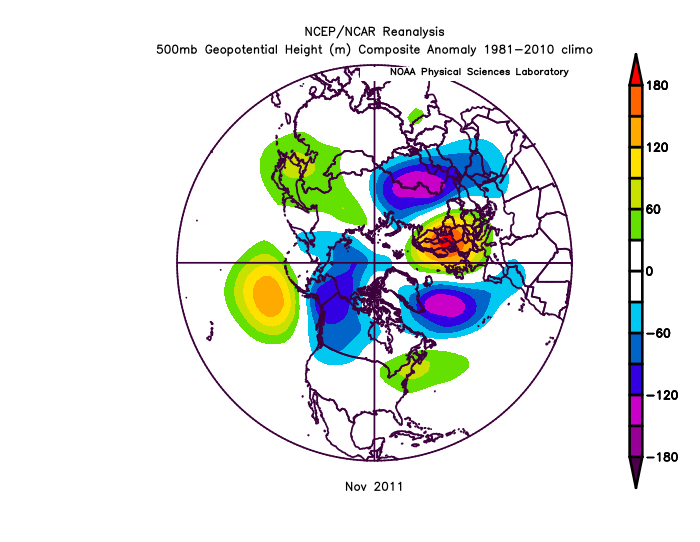
2011 is one of my analogs, so I do think there are enough similarities to this year to consider it. However, I don't currently see a pattern as perilous as that year: While Oct 2011 had some similarities over the Pacific, this year will have lower heights out west and higher heights in the east, and won't have as positive of an NAO in October. Then in November 2011, the super +EPO and +NAO took over and ended any chance of sustained winter that year: I currently don't think this year can go as badly as 2011 went by November...but, it is still something to consider if the +EPO doesn't start relaxing into November. We'll know in a few weeks if we're going the way of 2011 or not.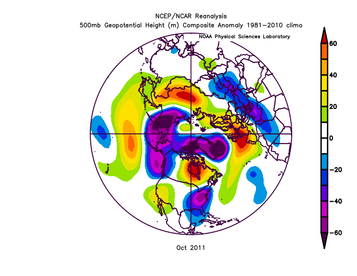
-
Some Thoughts on the Winter 2021-22 Outlook
OHweather replied to OHweather's topic in Weather Forecasting and Discussion
Now that I'm home and glancing through the actual write-up and some of the composites I did while working on it, I didn't include 08-09 in the "better" QBO match sets I used because it was too positive at 30mb through the winter (which I think is the correct move, I was worried that I included it in those sets which would've been a little iffy). However, the point about the downwelling easterlies above lingering westerlies does still hold IMO...the research about North Pac ridging in La Ninas based on QBO that those such as Anthony Masiello and Griteater have done over the last decade revolves around that lower-strat QBO, so this winter and 08-09 would both fall into the positive lower-strat QBO La Nina camp that has more amped north Pacific ridging.
-
Some Thoughts on the Winter 2021-22 Outlook
OHweather replied to OHweather's topic in Weather Forecasting and Discussion
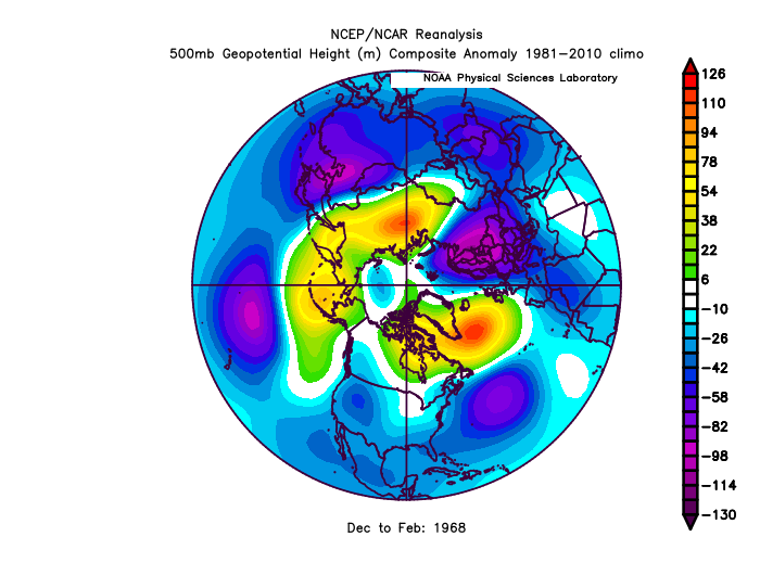
I can see that look playing out at some point mid-late winter if the ridging over the N Pacific is amped enough. The PNA should average negative so if / when the NAO goes positive we can get that look where it's cold west with a SE ridge in the east. As you alluded to we may not get a month that's quite that cold in the west but a couple of decent shots are certainly possible if not somewhat likely. I do hope that we don't go the way of what the mean of those winters looks like over the eastern CONUS, although outside of CA it's not as horrifically dry in the west which wouldn't be the worst thing in the world. 2011-12 scares me a little because it's quite a good ENSO match on the upswing portion of the solar cycle and a similar QBO to this winter. That year did not have as warm of a West Pac warm pool and had more convection occurred farther west over the Indian Ocean, which I don't *think* this year will do, but for eastern US snow lovers that's the kind of year that's a decent enough analog to scare you. 01-02 is off in enough other areas that it doesn't worry me, though it also was a ++AO winter. 67-68 was an interesting, blocky winter with a similar QBO to this year and I considered including it in my overall set of analogs...I ultimately decided against because it was farther back in time with a poor match in Indian Ocean / western Pacific SSTs and had more tropical forcing near the Dateline, which I don't think is likely this year. -
Some Thoughts on the Winter 2021-22 Outlook
OHweather replied to OHweather's topic in Weather Forecasting and Discussion
^ For those wondering, when I saw how awful my hair looked like in that video yesterday I went and got it cut after work. Important point of clarification -
Some Thoughts on the Winter 2021-22 Outlook
OHweather replied to OHweather's topic in Weather Forecasting and Discussion
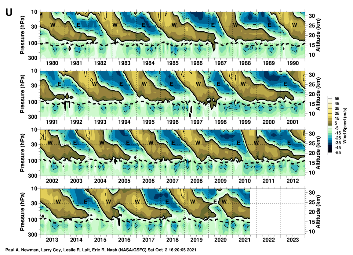
I agree it's an issue, but there are some QBO similarities that I liked. It was positive at 30mb through the winter, but easterlies were beginning to descend through the stratosphere during the winter with westerlies persisting through the lower stratosphere. This year is certainly farther along in the process and I think that will be conducive to keeping the vortex weaker (especially early in the winter), which may help the AO and NAO compared to 08-09. But when I was looking for QBO analogs (and comparing to "opposite years"), I looked for years with descending easterlies in which westerlies hung on in the lower stratosphere into at least early winter (whereas for opposite years, I looked for winters with descending westerlies with established easterlies in the lower stratosphere). 08-09 is not a perfect match but is in that part of the cycle, albeit earlier on.
-
Some Thoughts on the Winter 2021-22 Outlook
OHweather replied to OHweather's topic in Weather Forecasting and Discussion
17-18 is a winter that comes to mind in terms of being mild overall across the south but still having a couple of snow events when it got cold. I can see it happening this winter that way too, though maybe not quite as noteworthy as what happened in early 2018 along the Gulf Coast. -
Some Thoughts on the Winter 2021-22 Outlook
OHweather replied to OHweather's topic in Weather Forecasting and Discussion
I can see why the paper has 07-08 as hybrid. The DJF anomalies were quite cold west of 150W, which is why I called it a CP event, but the cooling in the fall was more basin wide. I think that event may end up being a bit more west based than this one (and certainly a good bit stronger which probably makes a larger difference) but I can see the reasoning for calling 07-08 hybrid. I agree that we aren't looking at an east-based event, which is why I'm a bit warmer in the south / east than a lot of those composites and included some stronger and CP events in the analogs, as long as they were decent matches for fall tropical forcing, solar, and / or QBO this year. I do think we likely stay away from an uglier look like 11-12 or 16-17 which were truly central Pacific based with their cooling. -
Some Thoughts on the Winter 2021-22 Outlook
OHweather replied to OHweather's topic in Weather Forecasting and Discussion
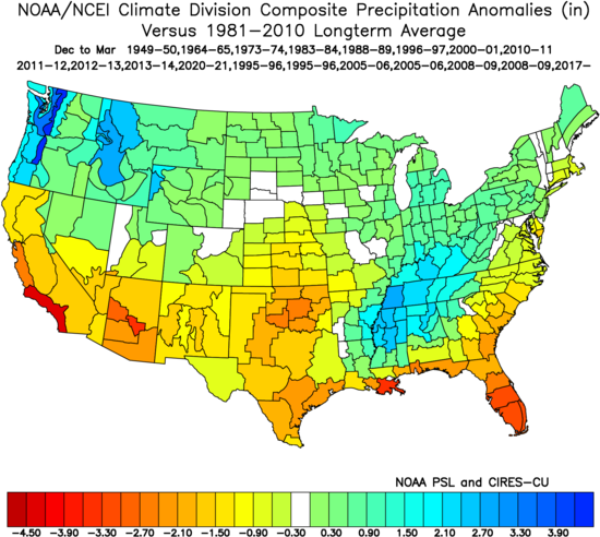
Yes, the gist of that graphic was to illustrate that in general, second year La Ninas are usually more hostile than first year La Ninas (with all second year events on the left), but non-strong second year La Ninas (especially those with the cooler waters focused farther east) mitigate that to some extent (on the right). It comes down to if there's enough blocking to get one or two big shots all the way to the Gulf Coast...a lot of things point to that at the moment, but if the La Nina gets stronger or becomes more firmly central Pacific based we're run the risk of things looking more like the map on the left there. -
Some Thoughts on the Winter 2021-22 Outlook
OHweather replied to OHweather's topic in Weather Forecasting and Discussion
I consider it "hybrid" right now, so not a true central Pacific event but it's not EP based either. If it trends towards moderate and the coolest water is pretty far west over the next month or so that could result in me pulling things in a warmer direction (especially in the south and east), especially if the pattern is looking more like those warmer analogs. Honestly I just went through each year and gave a designation based off of my impression of it (though most of them are the same as the paper). My reasoning for calling 08-09 a central Pacific based event was because the center of the cooling was firmly focused west of 150W, which is what the paper lists as the rough guideline, and because the eastern Nino regions never got that cool. I think it's firmly more CP based than this year (so far), though as you've alluded to probably didn't kill ruin the winter because it was on the weaker side. Despite this I think it's a good analog (second year La Nina, similar intensity, similar QBO, low solar, similar tropical forcing in the fall to what I currently expect this year) and is a double weight for me right now.
-
Some Thoughts on the Winter 2021-22 Outlook
OHweather replied to OHweather's topic in Weather Forecasting and Discussion
I remember you being all over the better blocking potential last year, so that's good to hear! The more seasonal outlooks one does, the more you realize that location of the ENSO (along with things such as QBO) are much more important than just "El Nino" or "La Nina", and the cited paper is definitely a great resource in La Nina winters. "Modoki" La Ninas aren't discussed quite as much as Modoki El Ninos but it arguably has as large of an impact, especially with non-weak events. -
Some Thoughts on the Winter 2021-22 Outlook
OHweather replied to OHweather's topic in Weather Forecasting and Discussion
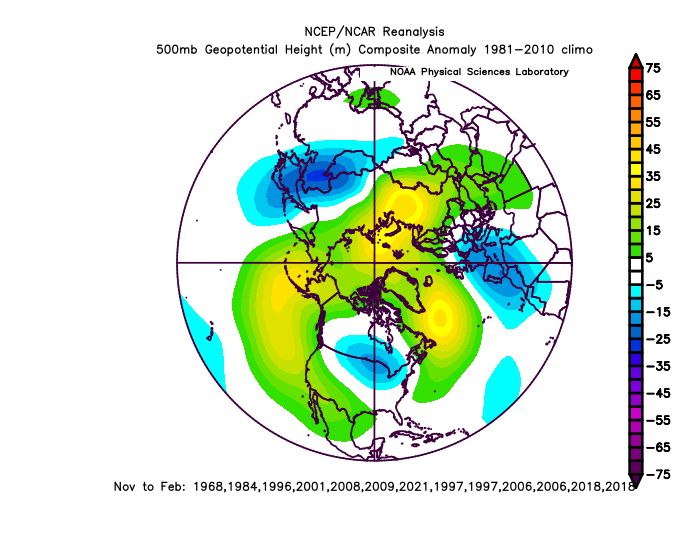
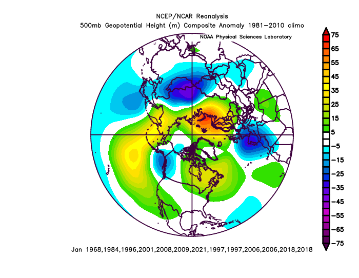
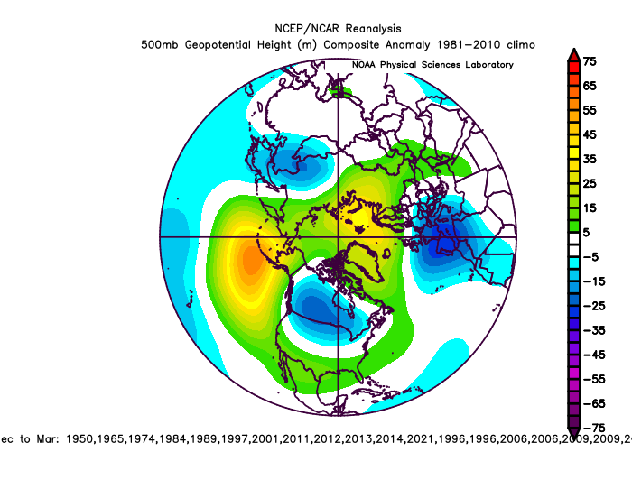
Thank you for your insight as always. A fair number of my analogs have a -NAO returning in March too...here's the mean 500mb pattern in my current analogs: I can see how the Plains or even Southwest get one or two big cold snaps this winter...the PNA will be negative at times (perhaps averaging negative for the winter) so if the EPO and AO stay positive some cold can get into the west.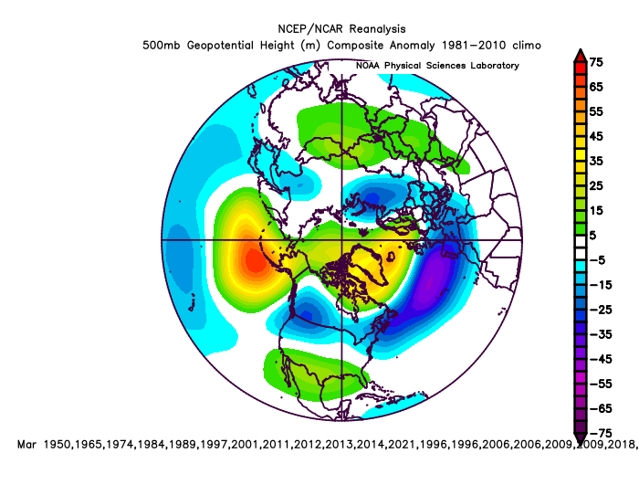
-
Some Thoughts on the Winter 2021-22 Outlook
OHweather replied to OHweather's topic in Weather Forecasting and Discussion
My thought is that there's blocking early, probably peaking in December, and then it backs off a bit through January and into February with the cold shifting northwest and more of a gradient pattern setting up as the SE ridge flexes. So I think it is cold early in the GL/OV and then is milder mid-winter. Snow may depend on where you are...up in Wisconsin it may be most active when the blocking relaxes, whereas farther south gets more of their snow when it's colder with more blocking. I think by November we'll have a decent idea on if the early blocking idea will pan out or not. There is an element of "could go either way" still this early. -
I like a winter with a fair amount of blocking (I think it'll average -AO overall) but also a somewhat -PNA. It's a La Nina so it'll be polar stream dominant and that'd be a chilly, active look for the sub-forum if correct.
-
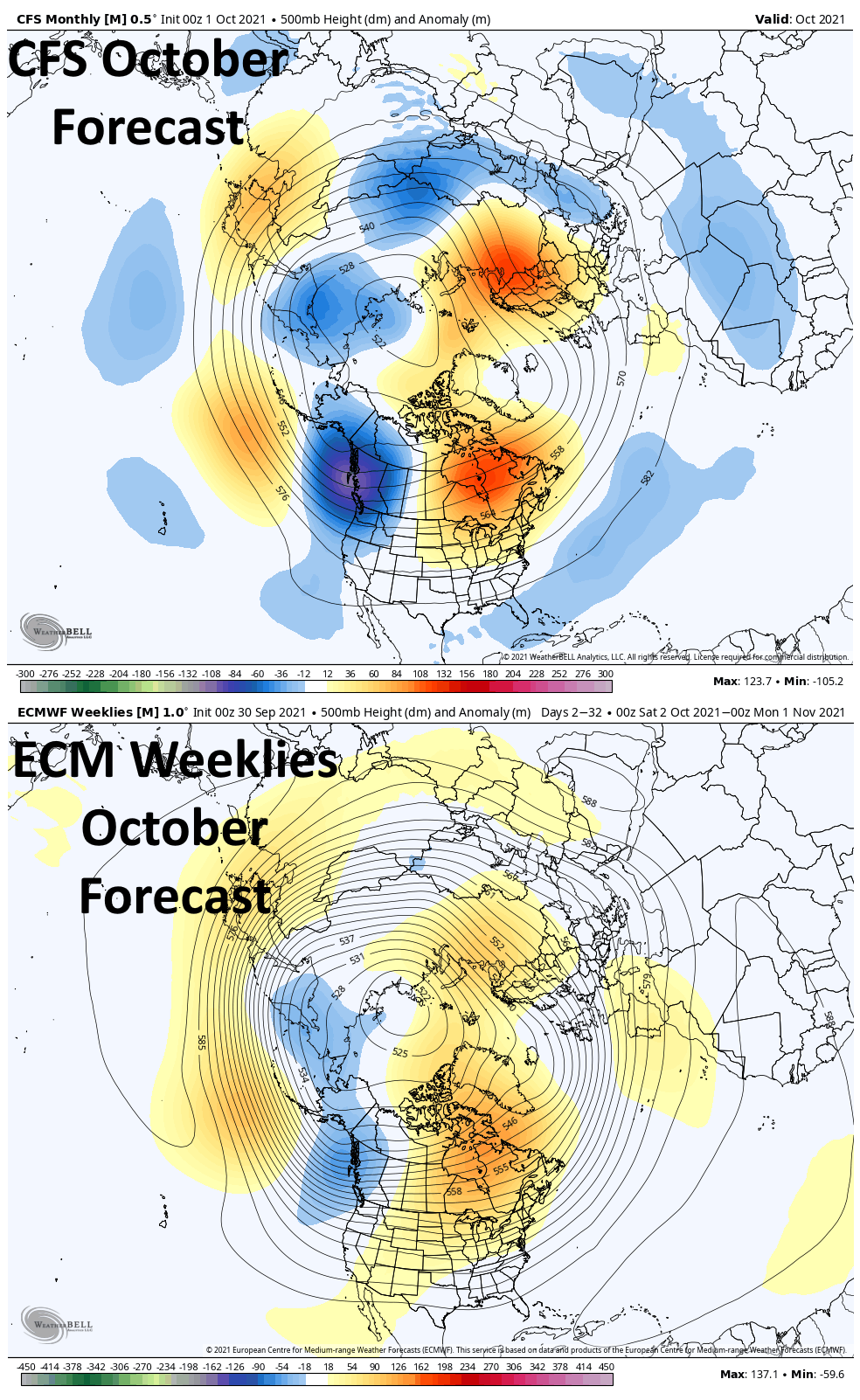
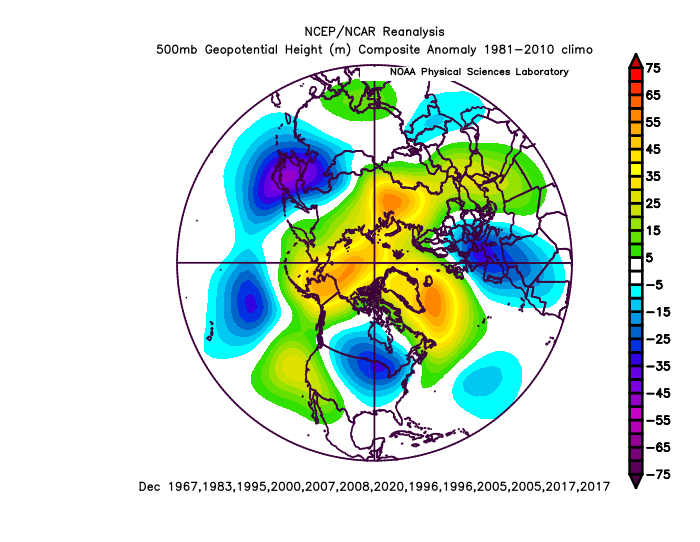
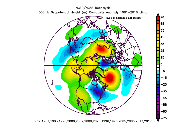
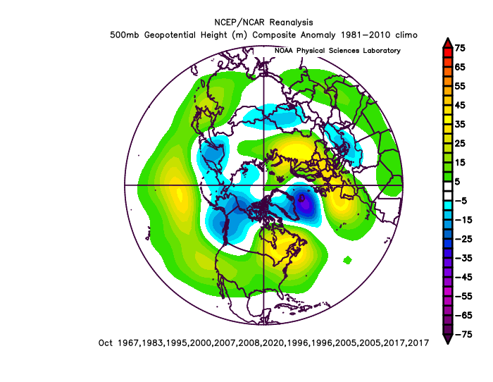
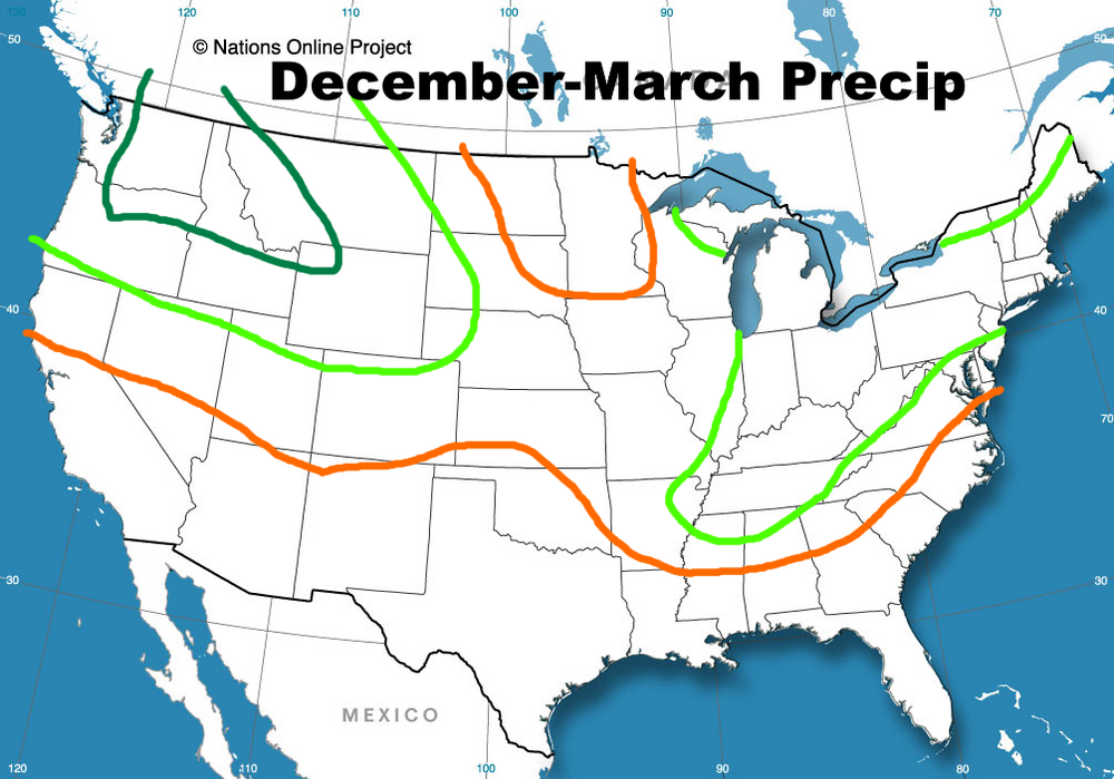
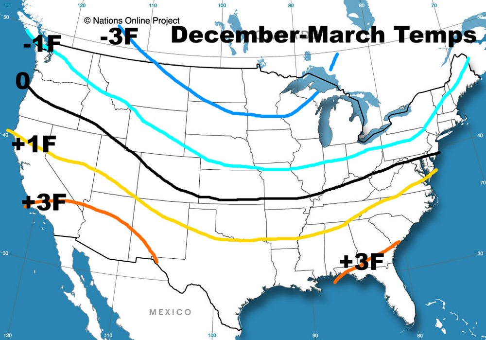
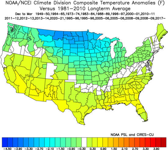
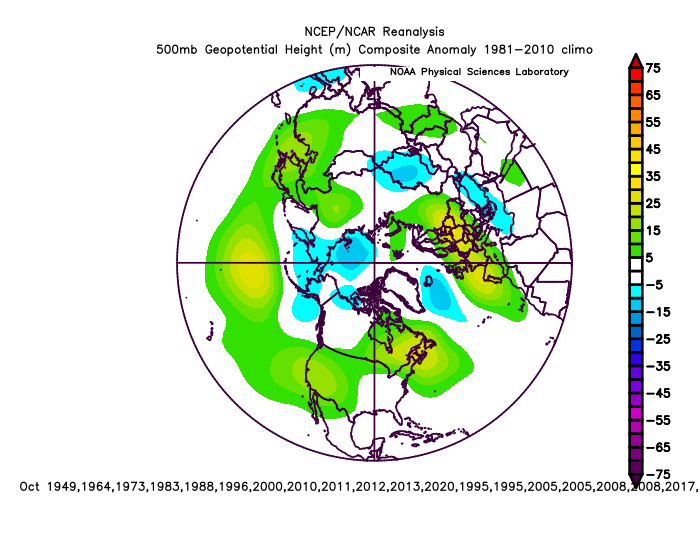
It’s still a little early on in the game, but we’re getting to the point where we can start narrowing down what various “pattern drivers” may look like this winter and examine analogs and even some seasonal forecast guidance for clues. For those who just want the maps, here are my current thoughts on temperature and precip through the winter. I’m lumping March into winter because it’s a month that can still prove to be productive for snow for many areas, and because many analogs are chilly in March. The detailed write-up with reasoning, analogs, and a look at longer range seasonal models is at the linked blog post (I'm exhausted from uploading the images on there, so I'm only going to upload a part of the post here). I hope to follow up with more focused thoughts in November, time permitting… My guesses on teleconnections: AO: Solidly negative. NAO: Near neutral or slightly negative overall, possibly large swings EPO: Near neutral or slightly negative overall. PNA: Negative, especially later in winter A stronger or more central-Pacific La Nina could pose warmer risks, especially in the central and eastern U.S., as would a strong stratospheric PV early in the winter that’s coupled to the troposphere. A quick increase in sunspots could also be a warmer risk. If forcing ends up more focused farther west into the Indian Ocean it’d likely point to a warmer winter. The La Nina staying weak to moderate and more basin-wide would point to a chillier outcome with more blocking being more likely. A weaker stratospheric polar vortex early in the winter, and tropospheric blocking developing in November, would also point towards a chillier / blockier outcome. Scandinavian or Ural ridging in October or November would also point towards a chillier and blockier direction, as would sufficient tropical forcing occurring east into the Pacific at times. I expect a very up and down winter, with very cold air frequently available over Canada that occasionally works south into much of the central and eastern CONUS this winter, along with the Northwest. The Southwest will generally be milder with a somewhat weak sub-tropical jet. The southern Plains, Gulf Coast, Southeast and lower mid-Atlantic will probably lean mild due to sharp warm-ups when blocking relaxes and / or the PNA shifts negative, though a couple of periods of EPO-induced cold all the way to the coast are possible. The most persistent cold will be in the northern Rockies and Upper Midwest. The analogs really like the first part of winter (December into January, possibly starting to turn colder in November) for blocking and cold into the central and eastern US (with cold focused more on the northwest in February). The analogs have a -EPO, -NAO, and -PNA pattern in March. I’m optimistic about snow in the northern Rockies and Pacific Northwest, along with from the Great Lakes and Ohio / Tennessee Valleys into much of the Northeast and New England. Along I-95 from Baltimore to DC and Richmond, events will be rainy at times when blocking relaxes so snow will struggle to reach or exceed normal, though there should be opportunities for wintry weather when blocking is strong enough to suppress the Southeast Ridge. I do want to post some maps based on the analogs I'm currently rolling with... And FWIW, the analog pattern for October is pretty close to what's modeled this year: Anyways, the rest of the write-up and a closer examination of the analogs is here: https://jimsullivanweather.com/2021/10/04/an-exploration-of-cool-enso-winters-and-a-look-at-winter-2021-22/

- 89 replies
-
- 10
-

-

-
I agree with you on the AO. But if anything that analog highlights...E QBO La Ninas tend to have a somewhat flatter N Pacific ridge than W QBO La Ninas, which does open the risk for the PV to sink into Alaska. So, it's a concern. There is at least some signal for a -NAO on analogs and models, so I do have some cautious optimism as long as the Pacific can behave. That year does have some interesting ENSO and QBO similarities to this year. There are other things (Atlantic SSTs and off-equator SSTs, along with summer tropical forcing) that differ from this year and kind of turn me off to it as an analog, but the winter look is somewhat similar to other years that I'm playing with WRT ridging probably centered W of Alaska with a -NAO.
-
Agree, when looking for analogs, unless it's an exceptionally strong event, I'll usually allow expected ENSO state plus or minus one (i.e. at the moment I'm playing with analogs ranging from cool neutral to moderate La Nina). I'll also heavily weigh things like QBO, whether an ENSO event is west or east weighted, the Indian Ocean Dipole and where lower-frequency tropical forcing is in the months leading into winter. So this year I'm playing with cool ENSO - moderate La Ninas, and looking (if possible) for ones with an easterly QBO, a negative IOD and a warm west Pac. Also, the lower frequency forcing this summer so far has been most favored over the western Pacific. It's an interesting set of analogs, with years like 74-75, 00-01, 05-06, 12-13 and 17-18 showing up in there, but also a disaster like 11-12 hitting many of those too.
-
Just to go on the record, I tend to agree that this La Nina will be slightly weaker than last year's given the surface is running noticeably warmer, though it's quite possible August's sub-surface anomaly is around -1, which would put it pretty close to last year's sub-surface "peak"...my argument is that at least a weak La Nina is likely, nothing too much more.
-
Nicce
-
Apparently the 0z ILN sounding had a +3C warm nose, which is a good 2C warmer than even those brave, sleety NAM runs yesterday.
-
Unfortunately would've liked to have seen the all snow line collapse a little farther SE over the last couple hours than it did. There's one more opportunity to flip before the dry slot with the slug coming into southern OH right now, especially for Dayton and Columbus, but I think everyone knows what their fate is. Accumulating sleet does count towards your seasonal snow total and it'll still wreck the roads, not that that's much consolation.
-
You won't get significant ice that far west, but you'll probably get more sleet than you want.
-
The ongoing mix will flip to snow in Cincinnati and Columbus as lift and rates improve over the next few hours (before probably going back to a mix this evening) so you'll still get some snow, but I-71 is definitely going to end up well within the gradient in totals with max amounts well to the west.