OHweather
-
Posts
4,957 -
Joined
-
Last visited
Content Type
Profiles
Blogs
Forums
American Weather
Media Demo
Store
Gallery
Everything posted by OHweather
-
This is almost like a "normal" stretch of snow for you guys these last couple of weeks, even if there hasn't been a huge storm to catch you up on your seasonal totals. Tonight isn't a great setup, but it'll snow decently when the front goes through this evening with some lake effect tonight...I agree with 2-4" probably for most of the snowbelt and even Cleveland area.
-
I definitely didn't love more than an inch of snow for Columbus or Dayton, so of course you guys are snowing. Probably another hour or two before the mixing line starts shooting north, so maybe another inch or so along I-70? I'm assuming it's accumulating pretty well.
-
Winter 2019-20 Medium/Long Range Discussion
OHweather replied to Hoosier's topic in Lakes/Ohio Valley
The research I've read (and that people generally trumpet) is that at the least, solar mins generally lead to weaker PV's...however, I haven't read any research actually linking mid-winter disruptions/hits to the PV, and there is some research suggesting that there is a lag, IE your greatest affects are felt just after the solar min (which would be the next couple of winters). Certain things argued for a weaker PV this year or tried to argue for it...usually, a warmer ENSO argues for it, but a warm Indian Ocean weakens the signal, and the warm ENSO was central Pacific based (weaker signal) and was not really strong enough to classify as even a weak El Nino (another weaker signal). Usually, a dropping QBO also argues for one, but I think it dropped just a bit too late to be helpful this winter. I do find it interesting that multiple signals pre-season suggesting a weaker stratospheric PV were just off, and allowed for this beast. If I had to scapegoat, I'd use the borderline record positive Indian Ocean Dipole, as that supported an unfavorable Asian-Pacific jet stream for polar vortex disruptions in the falll/early winter. I'm a little irritated that I sort of overlooked the Indian Ocean's influence on this winter (or hoped it would weaken quickly enough to avoid disaster). -
Thundersnow! Too bad the band lifted north of you two so quickly.
-
Winter 2019-20 Medium/Long Range Discussion
OHweather replied to Hoosier's topic in Lakes/Ohio Valley
The current "disruption" (if you can even call it that) to the strat PV was the last real hope to salvage February outside of the northern tier, and instead the PV comes back stronger than ever in the mid-range. It's been a winter I don't care to repeat anytime soon...nothing has shaken the pattern that started developing way back in December, and there have been several mechanisms to try to do so at various times.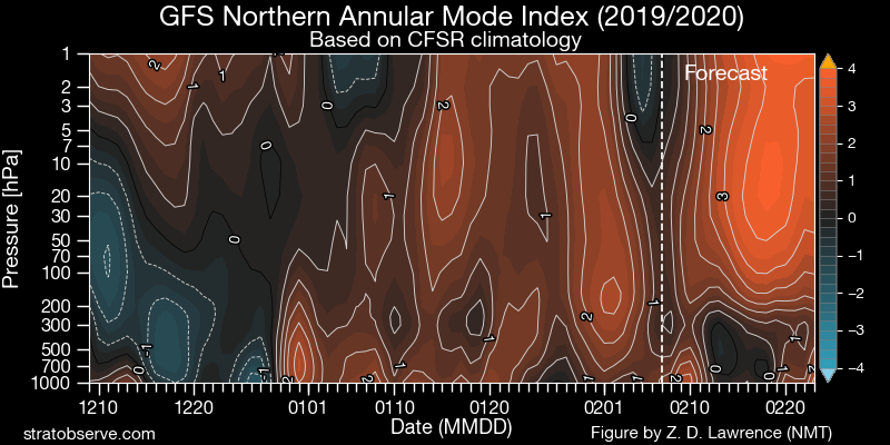
-
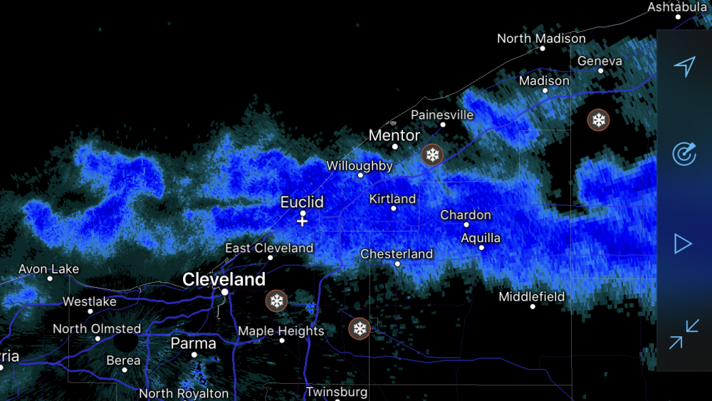
Definitely seems like a nice little event through the day today. I'm pretty intrigued by what happens through the evening and into the overnight, conditions are nearly ideal for very efficient snow growth and as the sun sets it will accumulate even better than it already is, with ratios probably exceeding 20:1 tonight. With a vort max over southern lower MI moving east across Lake Erie and extreme NE OH/NW PA this evening into tonight and the flow backing, increasing the fetch and also increasing convergence over the Snowbelt, I still think a few more inches could be squeezed out where bands are most persistent from the Cleveland area points east...with possibly as much as 6" in NW PA. Soundings remain OK into Saturday, so it may snow in northern Erie County into the morning before lifting out over the lake or into extreme SW NY.
-
The upper level energy is over Arkansas/Louisiana/Mississippi and will swing around the base of the trough and lift NE tonight. As that happens, the wave of low pressure near the GA/NC/SC borders will intensify, and the precip beginning to develop over Mississippi right now will expand and lift northeast. I do think it's mainly light snow from the upper level energy in Ohio, probably an inch for most, maybe a little more farther east (and also downwind of Lake Erie)...so certainly not too exciting, but I do think it will still snow. I'd keep an eye on that area of very light snow across parts of Indiana....that's probably what will flare up after midnight as the upper level lift arrives. As long as that stays west of you until morning you should see snow.
-
It was never supposed to snow until the middle of the night? It’s another relative disappointment in a winter of failure, but it’ll still snow a little on all of you later tonight into early Friday.
-
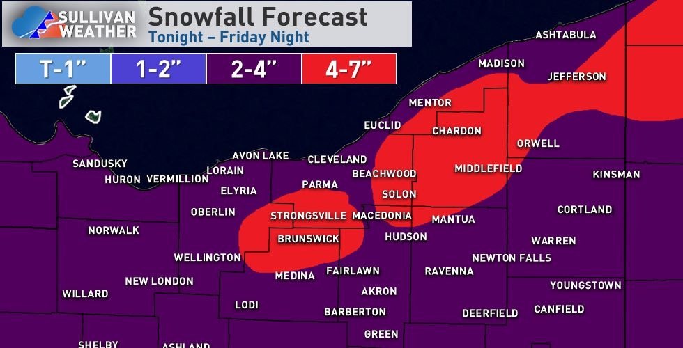
The NAM being too amped on the synoptic snow didn’t help, but also isn’t very surprising, which takes away the potential for a very nice event. I still think 4-7” is doable for much of the higher terrain in eastern Cuyahoga County and Geauga County into NW PA...the synoptic snow on its own likely produces 1-2” through mid morning tomorrow, with several hours of light to perhaps moderate lake enhanced snow late morning through mid afternoon, with a Lake Huron connection swinging west to east across the Cleveland area and Snowbelt during that window. I think that period drops another 1-2, locally 3” from mid morning through mid afternoon, focused on the higher terrain. Lake effect conditions are fair Friday evening and night...although instability isn’t extreme and EL heights are 8-9k feet which is a bit modest, steep lapse rates and moisture through the snow growth zone, weak shear, and increasing convergence near the lakeshore may keep moderate bands going through the night. They will gradually move and overall shift north by Saturday morning, but I could see Friday evening and night dropping another 1 to locally 4” in the primary Snowbelt. It does add up to several inches in the higher terrain, mainly owing to the duration and increasing ratios. Not a great storm, but it will have to suffice this winter...
-
Thursday night into Friday could be interesting for you guys...models trending a little stronger with the low pulling away to the east and throwing back some synoptic snow Thursday night into Friday morning, with lake enhanced snow continuing through the day Friday and some traditional lake effect Friday night. Assuming the synoptic snow can produce even 1-3 or 2-4", the added lake help could push widespread 6"+ totals in the higher terrain of the primary and secondary belts...could even see a run at double digits if the NAM is onto something with a solid several inches of synoptic snow.
-
Winter 2019-20 Medium/Long Range Discussion
OHweather replied to Hoosier's topic in Lakes/Ohio Valley
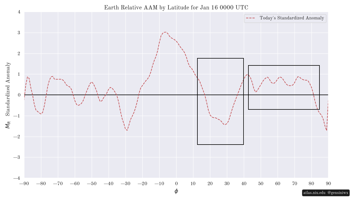
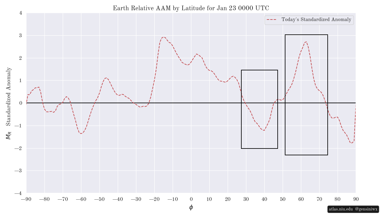
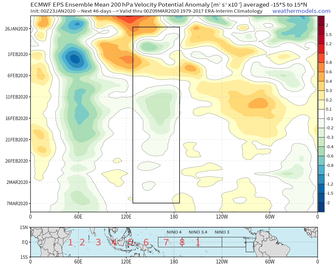
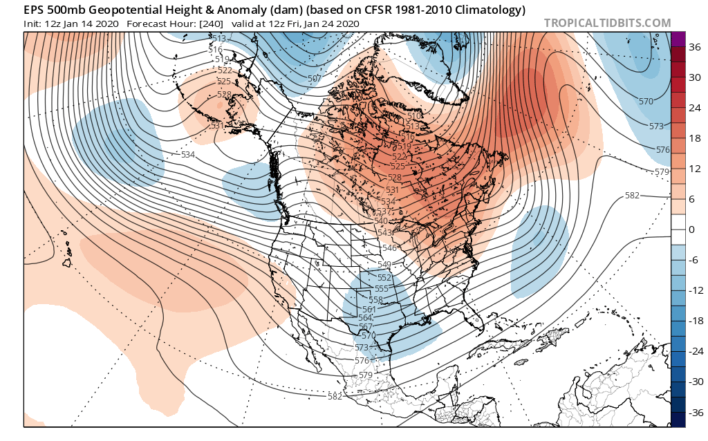
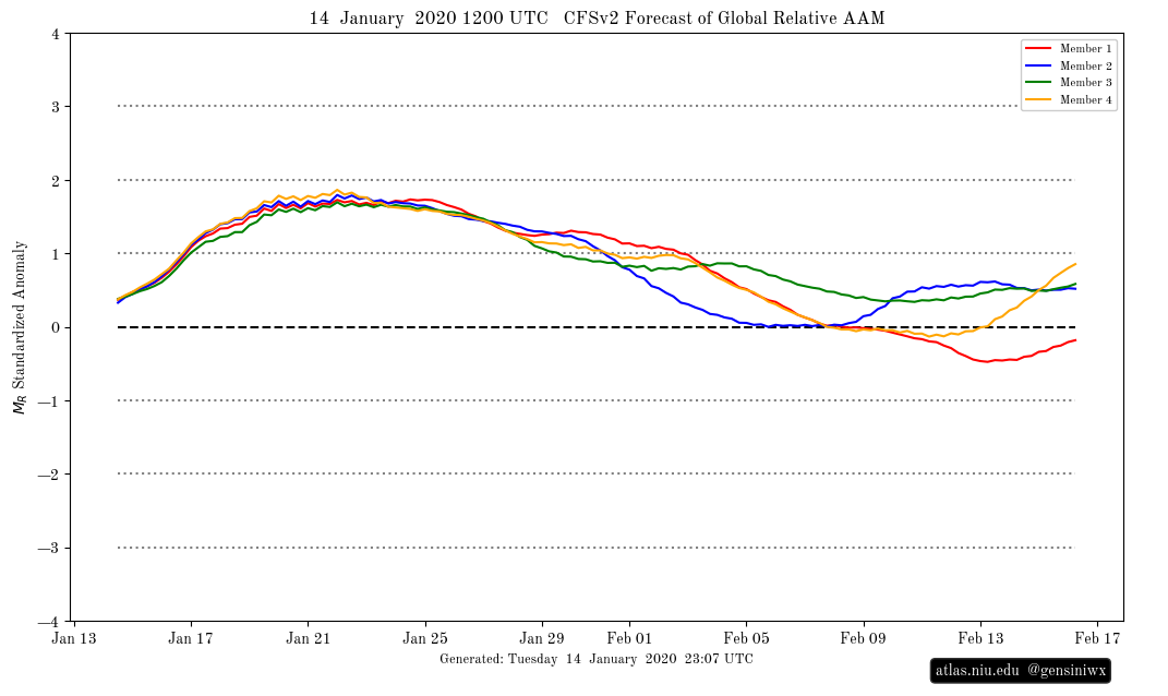
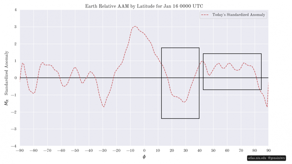
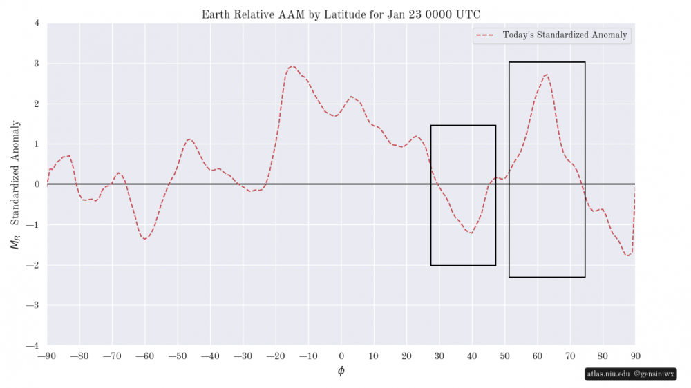
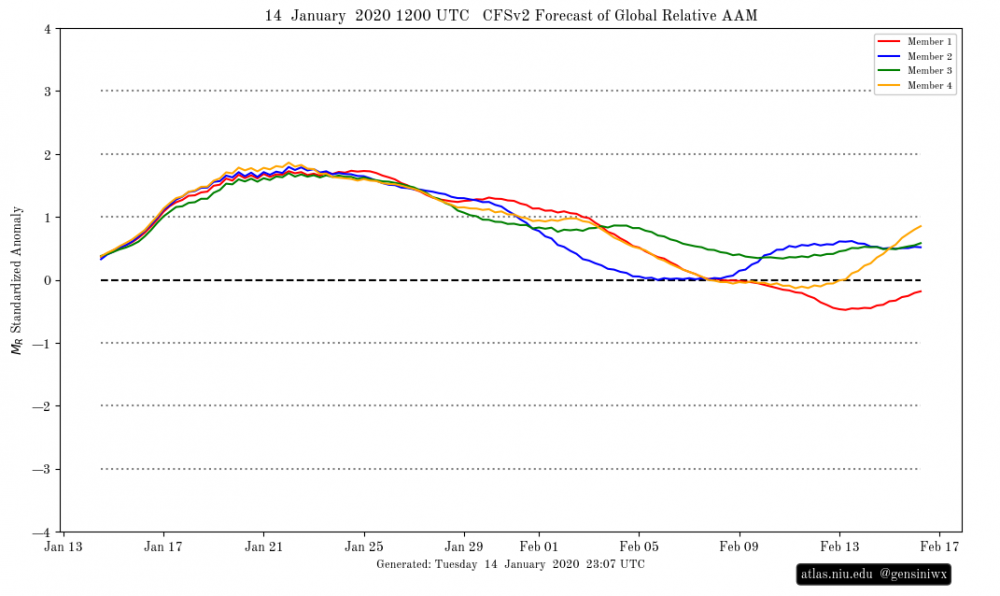
On the 14th I thought we were 10-15 days away from a more legitimate pattern change...clearly, things are not going as smoothly as I had hoped (though the upcoming pattern is not as bad as what we had for the last half of December and first half of January). A combination of a very strong stratospheric polar vortex (that is coupled to the troposphere), increased AAM not being deposited favorably yet, and MJO not making it into phase 8 are hurting us. I'll try to touch on all of these briefly and try to make an educated guess on whether or not they'll change. One point I've had to stress to clients at work (especially here on the East Coast where our snow climo is more back-loaded than the Midwest) is that we still average roughly half of our snow from here on out (it's about or slightly less than half for most Midwest stations off the top of my head). While the road begins getting narrow for deep winter cold and prolonged snow cover as we head into February, there's still time to snow. The issues we've faced this winter have gone back to a long-running issue since the fall...Indian Ocean forcing dominated the tropics for a good portion of fall and early winter, severely muting a weak/borderline central Pacific based El Nino for extended periods of time. Indian Ocean forcing is not a cold signal on its own in the middle of winter, and with a lack of Pacific forcing (which is a cold signal, especially when it's over the central/eastern Pacific), the stratospheric PV intensified quickly. The QBO not going negative until after the start of January provided a favorable background state for the PV to get strong, and there was minimal Pacific tropical forcing in December, which is peak intensification time for the strat PV and allowed it to get very strong. This wasn't a death knell on its own, but when this strong PV coupled to the troposphere in early January it became much more problematic. A strong stratospheric PV favors a +AO, NAO, and +EPO with troughing into the Pacific Northwest, which happens to be a common theme the last several weeks that does not go away despite what mid-range modeling says. We've seen much more robust Pacific tropical forcing the last few weeks as the AAM has sharply increased, which is why the models and people such as myself have been hoping for a change, but the strong and coupled PV has continued to dominate. The most recent MJO propagation and AAM surge are the most significant attempts yet to disrupt this pattern, and results while still uncertain, are not going to be as quick and effective as hoped, owing to the strength and persistence of the strat PV and its coupling to the troposphere. We'll start with the strong and coupled stratospheric PV: This is basically the AO with height...there was a cool tropospheric-stratospheric-tropospheric event in late November/December when a blocky troposphere sent waves up into the stratosphere that weakened the stratospheric PV, which then in turn down-welled and produced a period of blocking in the troposphere in mid December. Since then it's been off to the races, with the stratospheric PV getting strong by mid-late December and coupling by early January, with a very strong PV/positive AO throughout the troposphere and stratosphere. Until we disrupt this, a prolonged cold pattern or high-latitude blocking is unlikely. The good news is the stratospheric PV begins weakening climatologically fairly substantially in February, though is it quick enough to salvage much of anything? Tackling the AAM and its initial lack of impact on the pattern (usually an increase in AAM makes the high latitudes blockier and disrupts the stratospheric PV): AAM by latitude on January 16th: The initial issue was the added momentum was not getting dispersed into the high-latitudes due to a band of low momentum in the sub-tropics. You want momentum to increase in the sub-tropics and mid-latitudes and get dispersed in the high-latitudes...that did not happen initially, with high momentum dominating the sub-polar latitudes, likely at least partially due to the coupled and strong PV and resulting in a strong +AO. Here is the AAM as of this morning: That's not as bad, but still, there's a sink in the mid-latitudes indicative of a retracted Pacific jet and a band of high momentum in the sub-polar latitudes. The upcoming robust positive East Asian Mountain Torque should extend the Pacific jet and increase momentum in the sub-tropics and mid-latitudes more than what we've seen so far, and is actually still fairly on schedule compared to what the ensembles were hinting at back in mid-January. The EAMT looks fairly positive for the foreseeable future, though with notable peaks in the near-term, and potentially again in the 10-15 day timeframe. Both should increase momentum in the mid-latitudes, we will see if that momentum gets properly dispersed into the higher latitudes in the face of the strong and coupled PV or not. And this could be quite a strong +EAMT if that high descends in the extended range: Tropical forcing remains more favorable than it was, despite the failure of the MJO to make it into phase 8...both the EPS and CFS suggest some uplift continuing over the central Pacific in February as the Indian Ocean uplift slowly weakens...the brief and weak phase 5-6 MJO shown next week on the RMM plots is a fast-moving Kelvin Wave that should help amplify this lower-frequency central Pacific forcing in early February: Also, as wavelengths shorten through February, Indian Ocean forcing becomes less detrimental. So, long story short, the strength of the stratospheric PV is both causing the bad pattern we've been in and making it more resistant to change than normal. However, climatology, more active Pacific tropical forcing, an increase in momentum in the mid-latitudes due to positive East Asian Mountain Torque events, and shortening wavelengths all suggest that the stratospheric PV should gradually weaken, and in fact the extended range GFS op and EPS, which have both done well with showing a strong PV through the winter, do show some signs of weakening by early February. I am somewhat in the camp of "I'll believe it when I see it" myself in regards to any sort of change to a substantially colder pattern, but the EPS weeklies and CFS continually show a seasonable to somewhat cold pattern developing during the first week of February and generally continuing through the month (with some ebbs and flows), and if we can ever shake the strong PV and the pattern it has created, the other sub-seasonal forcings don't really argue for warmth...the question is, can we do it in time to salvage a good chunk of February? I don't know the answer and have gotten burned by being too optimistic on that timing over the last few weeks. I do think in the next two weeks that we'll see the PNA spike positive at times as the +EAMT extends the Pacific jet, though the AO, EPO, and NAO will be a different story until the stratospheric PV gets knocked back some. The earliest that can start occurring is 10-15 days from now, though I suspect it's not until at least the second week of February that we see more material changes in those areas, and until that time it will be tough to lock in any sort of cold air. However, any PNA spikes may give us enough polar influence to make all of this subtropical jet energy running around at least a bit interesting in the meantime.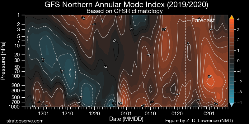

-
The secondary Snowbelt has gotten crushed this evening...CLE has been reporting 1”/hour snow rates the last two hours with ratios of 50:1 if the liquid catch is accurate! KCLE 200451Z 24007KT 3/4SM -SN BR VV011 M07/M09 A3034 RMK AO2 SLP288 SNINCR 1/4 P0002 T10671089 400001089
-
Winter 2019-20 Medium/Long Range Discussion
OHweather replied to Hoosier's topic in Lakes/Ohio Valley
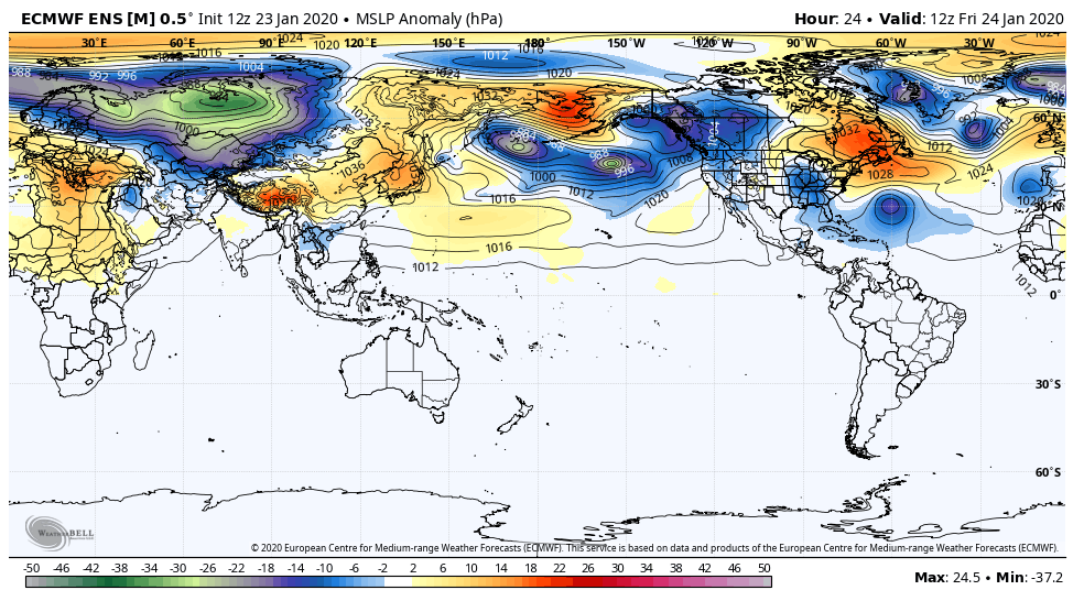
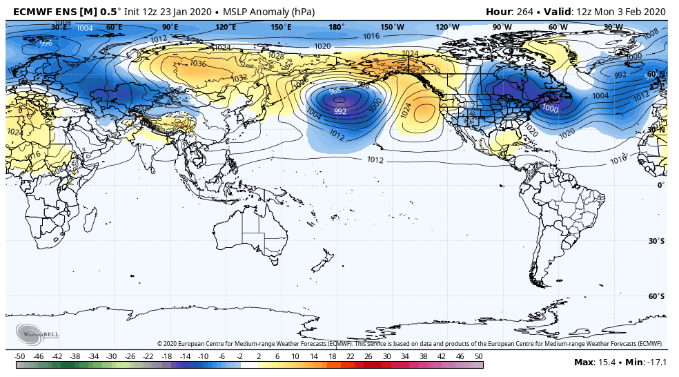
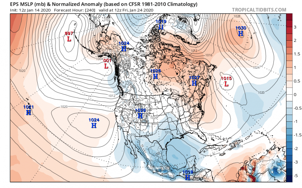
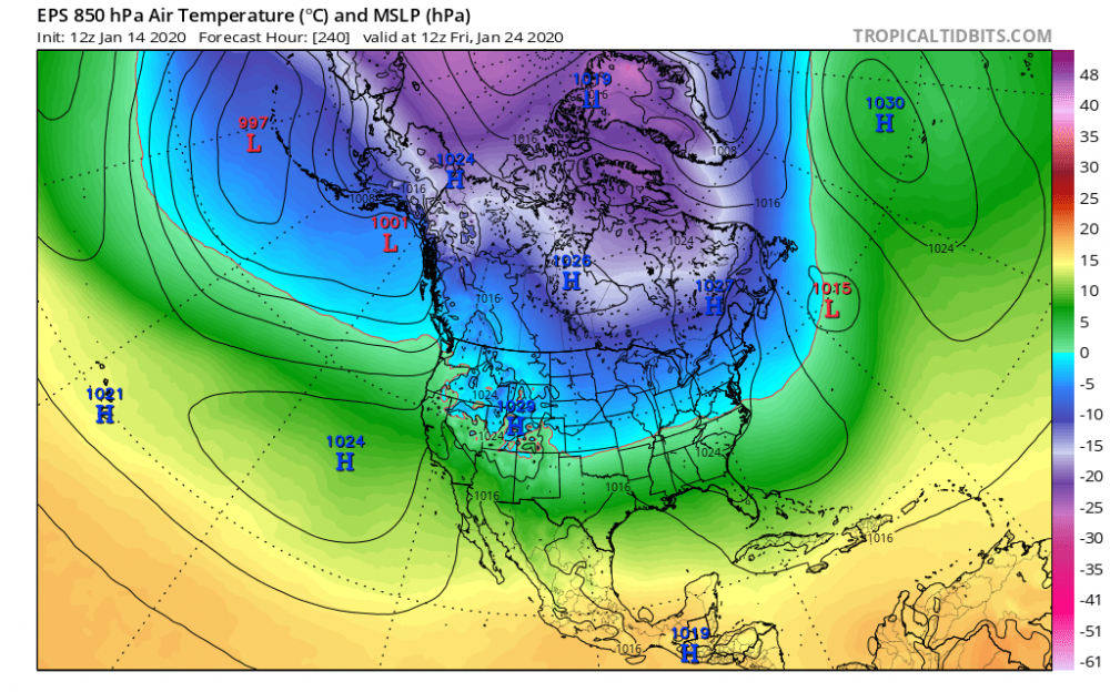
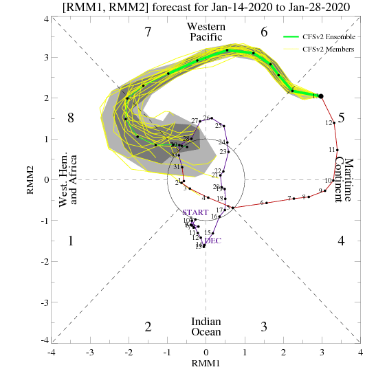
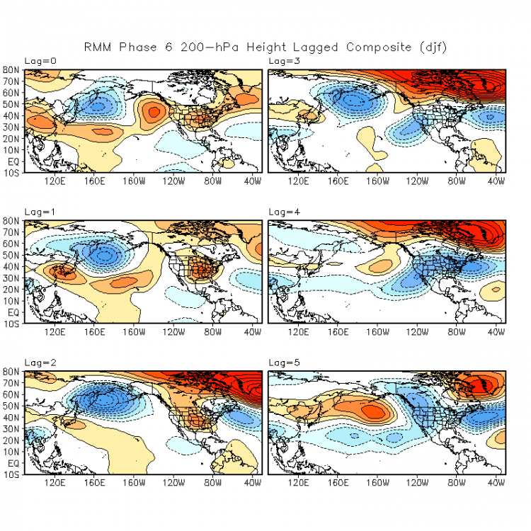
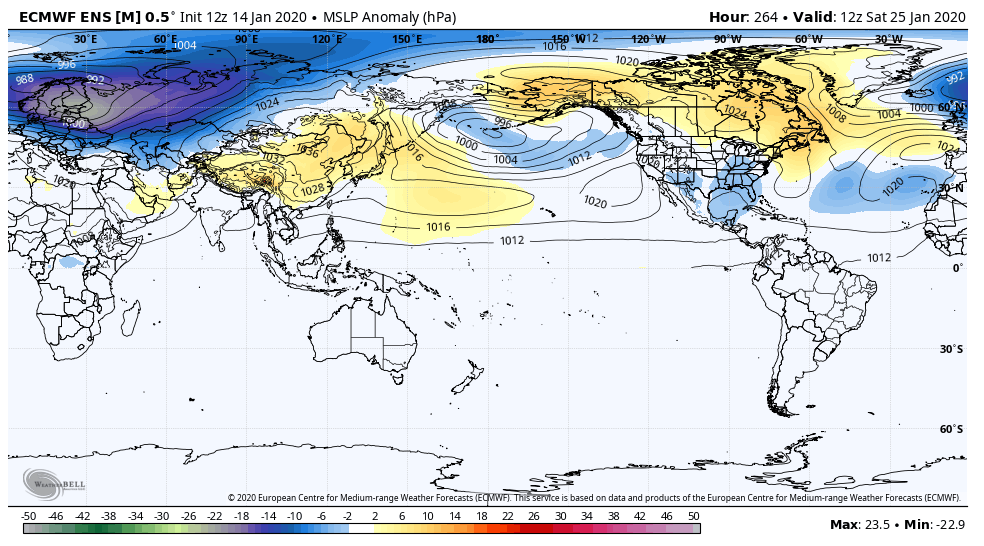
I'm just here to spread false hope of a pattern change that'll never come (though we're already setting things in motion this week with a brief -EPO that does dump a good amount of cold into Canada and the eastern half of the U.S.)... I don't totally hate the odds of a storm/event around the 23rd-25th across a good portion of the sub forum, with fairly strong ensemble support for a decent shortwave to eject out of the southwest. With some bootleg blocking across Hudson Bay, lower heights over the southeast, and surface ridging over the top ahead of this feature, I think there's a good shot it's wintry. 850mb temperatures are near normal (after being cold for a few days prior) and are workable with the ensemble mean 0C line south of the Ohio River ahead of this wave. If it deepens too quickly it would still cut and change the Ohio Valley to rain (or perhaps simply give them mostly/all rain), but places like Iowa/Wisconsin/Michigan, Chicago, Detroit, and maybe even Indy/Toledo/Cleveland would probably see a half decent amount of snow if an organized system can eject in this time-frame. Places like Pittsburgh and Columbus/Dayton/Cincinnati still can snow but would likely need to root for a more strung out system, as the "blocking" to the north isn't strong enough to stop a stronger system from cutting too early for them. As for the "pattern change", both the tropics and extra-tropics don't really say it should be here yet...I think the ensembles several days ago (and hence those of us rooting for a pattern change) rushed the change a bit, but things suggest it's probably still 10-15 days away from really being "there"... The MJO is at an extremely strong amplitude in phase 5/by tomorrow 6...these are not cold phases, though do usually end up being cold within 2-3 weeks of their occurrence. Here are lagged composites of what happens after a phase 6 MJO at an amplitude of 1 or greater...although the MJO accounts for something like 25% of the sub-seasonal variability observed over a large sample, this is a very strong MJO and will influence the pattern. Each lag is 5 days. This does not suggest a more legitimate pattern change that dumps cold into the CONUS for another 10-15 days (though does suggest slightly faster high-latitude changes, which we are seeing). Phase 7, which we'll reach in 5-7 days, leads to cold by lag 1 which is 5-10 days (and supports the timeline from a current phase 6) and is typically cold thereafter for quite a while. Phase 8 is cold immediately and for quite a while. Here is a link to these composites for anyone interested: https://www.cpc.ncep.noaa.gov/products/precip/CWlink/MJO/LaggedComposites/ Basically, tropical forcing says we should not yet be cold and probably shouldn't be for another 10-15 days, so it's probably not that surprising that the mid-range guidance has delayed a persistent cold pattern but still shows one developing past day 10. This should start moving up in time as the MJO keeps propagating. Global angular momentum (GWO, AAM, GLAAM, whatever your acronym) will rise soon, but it hasn't yet. A low AAM is more typical of a La Nina, supports a strong stratospheric polar vortex/+AO, and trough over the western U.S. We have been gradually climbing towards a more persistently positive AAM since the middle of fall, but it's been a slow climb, and I think the AAM slipping negative for most of December (after a couple of positive attempts in November) contributed to the strong stratospheric PV and +AO we are dealing with right now. It spiked at the end of December, but the tropospheric pattern was horrible with a PV over Alaska and the stratospheric PV was too strong for that spike to significantly disrupt it. The strong MJO over the next two weeks, along with a fairly strong East Asian Mountain Torque (high pressure east of the mountains) will add a lot of momentum over the next two weeks, and we will see the strongest positive AAM spike of the fall/winter by far. Here is the EPS sea level pressure anomaly forecast for hour 264 showing this strong mountain torque, along with the CFS AAM forecasts for the next month: This added momentum will help fuel an already active sub-tropical jet, will support some jabs to the stratospheric PV, and the MJO moving through the western Pacific as a +East Asian MT occurs will support significant amplification in the EPO/PNA domains. Basically, I understand it's frustrating waiting a bit longer after over a month of really unfavorable conditions for snow for most of the sub and that it may seem like the models are perpetually pushing cold back, but there are reasons we didn't flip as quickly as the models suggested..basically the drivers didn't support it yet...and there are numerous reasons to expect it to still change soon. The combination of factors we will see the rest of this month is unlike anything we've seen so far this fall/winter and I would be flabbergasted if it didn't result in a shakeup in the pattern. I think the trick will be figuring out if we go back to warm in mid-late February, or if it's a more prolonged change that carries us through the rest of winter. I don't know the answer to that yet. After the potential system around the 23rd-25th (that favors the northwestern 2/3rds of the sub) there may be a similar opportunity a few days later. Thereafter individual threats become murkier, but it should stay active and I think we see the EPO drop more than the EPS suggests in the 10-15, which will eventually push the baroclinic zone far enough south to favor the Ohio Valley over the Great Lakes.
-
Winter 2019-20 Medium/Long Range Discussion
OHweather replied to Hoosier's topic in Lakes/Ohio Valley
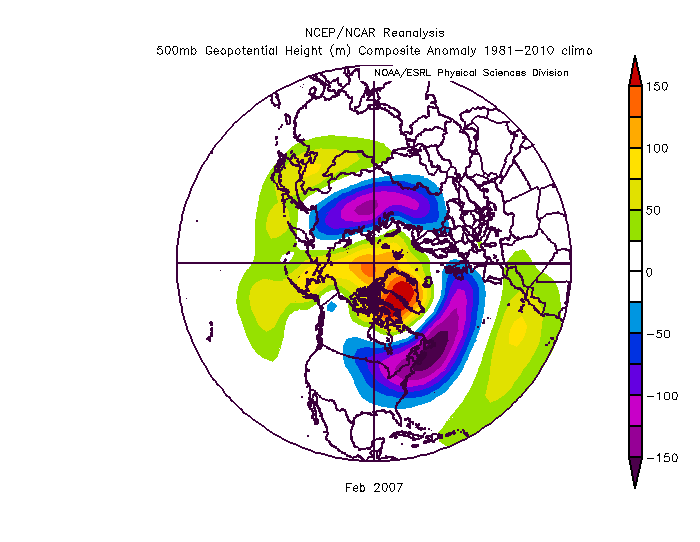
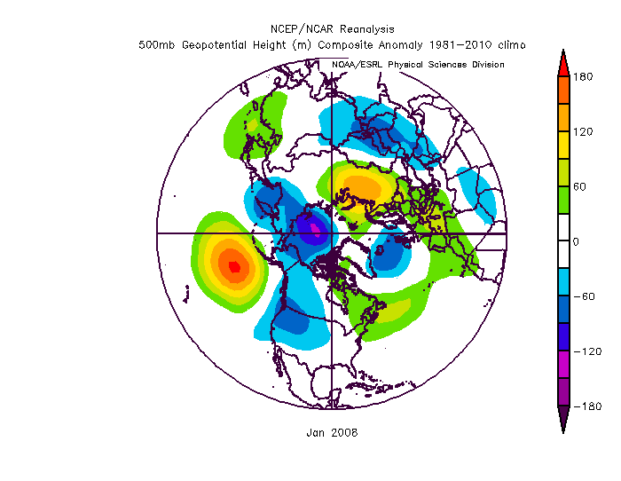
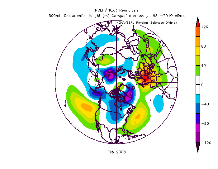
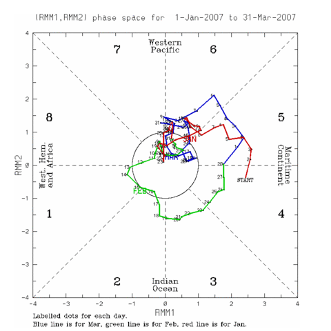
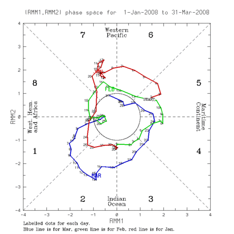
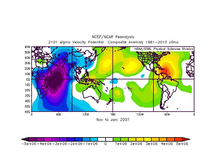
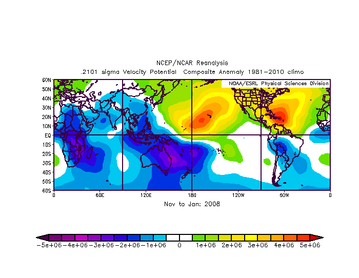
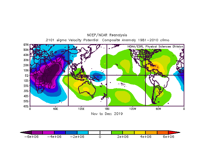
I'm sorry for the horribly slow response to this...there could be a window around the 20th before the ridging develops on the West Coast for a larger storm somewhere in the Great Lakes or northern Ohio Valley. After that, as RC suggested, once a PNA ridge develops on the West Coast the trough axis likely shifts far enough east that any synoptic storms are a little too suppressed for the Great Lakes. However, with ridging into the EPO domain, it'd be a cold pattern that would likely feature clippers at least. Yeah I'm a little frustrated about how winter has gone so far. I think it's been a case of being just a little off...the QBO didn't go negative at 30mb until after January 1st (it should finally be negative this month), and the +IOD forcing was so strong that it suppressed Pacific forcing quite a bit...most notably in September and October, and again in December. This combined with the QBO still being positive at 30mb to start window allowed the stratospheric PV to wind up quite a bit to start winter. Pacific forcing favors Aleutian low development which is the way El Ninos tend to disrupt the stratospheric polar vortex. I think if the QBO dropped a little quicker, or if we had more persistent Pacific forcing in fall/early winter that we'd have been in a much better spot right now. We weren't and there's still time, but I agree it sucks to lose such a large chunk of the season. In September-October I was worried about something like this happening, but in November leaned against it when Pacific forcing flared up for much of the month and we did disrupt the strat PV...I regretted it by mid-December when the +IOD base state re-emerged. It seems nowadays that if there's a reason for a warm pattern that you're losing a big chunk of winter, even some of the good winters (13-14 a notable exception) have had prolonged mild spells the last decade. I've seen comparisons to both 06-07 and 07-08 recently...both have interest because after relatively s**** first halves they improved markedly for the second half, with robust MJO passages into the western Pacific in January likely at least helping both turnarounds. Ironically I think the QBO and low-frequency tropical signal favor an 06-07 evolution over an 07-08 one, though the composite for this month may end up looking more like January of 08 than January of 07. Here's the 06-07 evolution: And 07-08 Here's the January-March 2007 and 2008 MJO, followed by current EPS projections (which I think weaken it too quickly, it should get into phase 8): So, the January pattern this year looks closer to 08 with an Aleutian ridge, as does the MJO (especially if it gets farther around than the EPS has, which I think it will given how robust this wave is). However, 07-08 had a much more decidedly La Nina low-frequency forcing pattern in the November-January, and we are a much closer QBO match to 06-07 this winter...here are the November-January velocity potential anomalies for 06-07, 07-08, and November-December this year (with the expectation that January will strengthen the uplift signal over the western Pacific somewhat): The lower frequency signal being more Nino like in 06-07 is probably why we had a much more El Nino like pattern during the second half of winter with a -NAO compared to 07-08. If I had to look at the pattern now, I'd say an evolution closer to January-February 2008 is more likely than a 2007 evolution, that just looks closer to what we're seeing now. However, the tropics being somewhat more Nino like this year and a descending QBO would normally argue for some blocking. Given the robust MJO ongoing, low frequency forcing, and QBO, I think IF we perturb the stratospheric PV more substantially the second half of January that we probably see some sort of attempt at a -NAO, but if the PV remains strong (which it has so far this winter) we may end up paralleling 07-08 a little bit better and keeping a +NAO with more of a SE ridge. My impression is we are going to see more -EPO help than either 06-07 or 07-08 had regardless, but there are arguments to be made either way regarding the Atlantic side which has big implications for the Midwest and East Coast...a -EPO but little Atlantic blocking is much better for this subforum than a -EPO and a -NAO. Either way, it seems like a transition back to a colder pattern is likely starting in about a week, with a robust MJO moving into the western Pacific being the catalyst for it.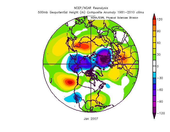
-
Winter 2019-20 Medium/Long Range Discussion
OHweather replied to Hoosier's topic in Lakes/Ohio Valley
My early thought is it's a poor early spring...that's been the theme, a lot of analogs have it, and I think we're kind of wasting our western troughs now. I can see something similar to last year where it's a slow start, but eventually flips to something more exciting in later April or May. -
Winter 2019-20 Medium/Long Range Discussion
OHweather replied to Hoosier's topic in Lakes/Ohio Valley
It's a bad pattern for snow (outside of a fluke event that I wouldn't get excited about until it's two days out) until at least the 20th-ish...jussst so we're clear I'm not expecting a flip anytime soon, but I think one comes before the end of the month. -
Winter 2019-20 Medium/Long Range Discussion
OHweather replied to Hoosier's topic in Lakes/Ohio Valley
Yeah this pattern looks nothing like a strong El Nino...we'd have a giant negative anomaly just off the West Coast pumping a ridge over most of the continent with a modest trough over the SE, about the opposite of what we have now. The issue has actually been a general lack of thunderstorms over the Pacific keeping the Pac jet too weak/retracted, putting ridging south of the Aleutians/near the Dateline (which is too far west) and a trough on the West Coast (pumping the SE ridge). We had our most interesting pattern in and around November when we actually had a more prolonged flare-up of convection over the western/central Pacific. We should get another more prolonged flare-up mid-January through the first week or two of Feb over the Pacific which is why I think a shakeup is coming. It's going to be very cold over Canada and once we dislodge that south we may flip pretty abruptly. -
Winter 2019-20 Medium/Long Range Discussion
OHweather replied to Hoosier's topic in Lakes/Ohio Valley
There’s light at the end of the tunnel...it will turn colder after mid-Jan. Just hope it’s gradual and doesn’t become suppressive too quickly. Either way this break from winter isn’t going to last forever. -
Winter 2019-20 Medium/Long Range Discussion
OHweather replied to Hoosier's topic in Lakes/Ohio Valley
I suppose I can add some thoughts...I'm not extremely optimistic for the Midwest for the next few weeks, unfortunately. I guess I'm not optimistic for the East Coast either, it's just a crappy pattern. The polar vortex settling over Alaska this week is offsetting a couple of other mechanisms that would otherwise try to give us an EPO-induced cold shot to start January. Convection has flared up over the Pacific the last several days, which the MJO plots are picking up on, and there will be a brief East Asian Mountain Torque next week. Both mechanisms often pump a ridge into AK, but the polar vortex being parked there is stopping that...so instead of getting a legitimate cold shot, we get that glancing blow a few days into January. Beyond that, tropical forcing and the stratosphere favor an expansive Southeast Ridge flaring up during the middle third of January. This will probably bring another week to two weeks of mild weather to most of the sub-forum (places like MN and northern WI/MI possible exceptions). I think that tropical forcing works back towards the western and central Pacific for late January and that the stratospheric PV is a little weaker by then. The tropospheric PV should also be out of Alaska by then. Basically, I think we try to amp a ridge into Alaska and western Canada again in late January and that things are much better aligned for it to actually work out and deliver cold late January into early February. In terms of snow potential, it's definitely eh for the next few weeks. There will briefly be a decent W-E temperature gradient from next weekend through the 10th or so of January that could bring some risk for snow...particularly between the 8th-12th on the front end of any shortwaves ejecting out of the west (and bringing an eventual warm-up). The period doesn't excite me that much and the farther north, the better, but I suppose that's probably the next set of things to watch. As unexciting as this all is, there is still plenty of winter left starting in late-January, despite some recent calls on Twitter to punt the rest of the season because the pattern is turning poor for a few weeks. -
I'm going to be in NE Ohio for a few days, and am excited to at least see some flakes Wednesday night. I doubt I'll see much in northern Summit County (maybe a dusting), but it's a pretty moist upslope setup so the higher terrain in Geauga could certainly squeak out 2-4". It's marginal temperature wise and not that intense so the lower elevations will probably struggle mightily.
-
Winter 2019-20 Medium/Long Range Discussion
OHweather replied to Hoosier's topic in Lakes/Ohio Valley
I think there’d be a window before the trough settles in for some sort of snow and then during the second week of December as it starts warming up. It’s not optimal and yeah that mean would be too suppressive for a time, but I think it boils down to a 10-14 day period of below average temperatures with a somewhat active southern stream...it may not work out but I think enough ingredients are there for opportunities. -
Winter 2019-20 Medium/Long Range Discussion
OHweather replied to Hoosier's topic in Lakes/Ohio Valley
Even if the op runs aren’t as exciting with individual threats right now, I’d still role the dice with this pattern with an active jet out of the southwest and a -EPO that gradually pushes the baroclinic zone south. It’s not perfect but should work for someone eventually, and it will take a while for above normal temperatures to return. Also, 1. Someone should see snow in Ohio tomorrow even if it’s not over Angry’s head (might be a little to the east/northeast of him) 2. Last winter was better than average for a majority of the sub, so a repeat wouldn’t be the worst, but the pattern should feature more blocking this winter so those on the southern and eastern fringes that didn’t do as well as everyone else last winter may make up for it this year. Most places are already off to a decent start with no signs of any prolonged snowless/warm patterns through mid-December.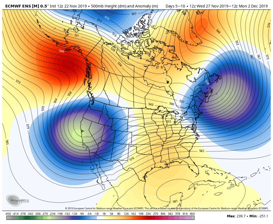

-
Winter 2019-20 Medium/Long Range Discussion
OHweather replied to Hoosier's topic in Lakes/Ohio Valley
The look of a -NAO, -PNA and active sub-tropical jet would be very good for a lot of this sub-forum starting around the end of November (though intially may favor those in the northern half of it). If the EPO drops after day 10 as the ensembles are trying to hint at that would eventually shift the baroclinic zone far enough south for the Ohio Valley to also get more in the game for early December.
-
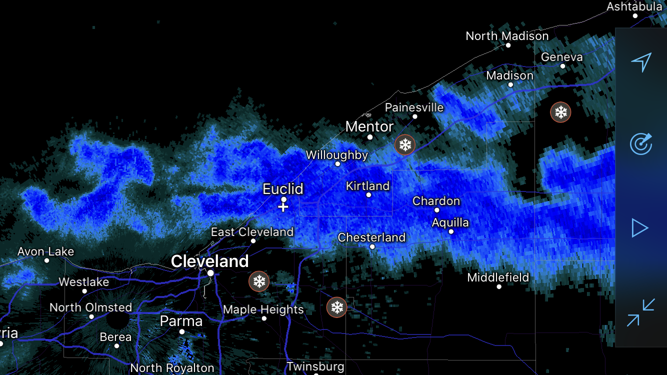
Some big totals coming in from Geauga and Ashtabula. A lot of areas at 10-15” so far adding the reports together. We’ll see how things fill in report wise farther west. Glad you guys both got into the double digits!
-
It seems like the shear kept bands a little bit too disorganized to really add up in any one spot (except for parts of Ashtabula County into western Crawford County who are getting crushed). There should be another flare-up in a few hours as winds turn more WNW and we get some Lake Michigan moisture, but it's likely fairly modest...maybe another 1-3" in spots. Edit: a couple of reports ranging from 8-11” near Wellington in Lorain County for the surprise of the storm so far.