OHweather
-
Posts
4,957 -
Joined
-
Last visited
Content Type
Profiles
Blogs
Forums
American Weather
Media Demo
Store
Gallery
Everything posted by OHweather
-
My 2020-2021 Winter Outlook
OHweather replied to OHweather's topic in Weather Forecasting and Discussion
Thanks for linking me to your outlook. I remember reading your outlooks the last two winters, and you were right to be more bearish with snow along the East Coast than a lot of others (including myself) were. All of the connections you find are interesting and work in multiple different examples; I'd suspect a lot of it is interconnected to the larger pattern that drives a given season, and it's interesting how that can manifest itself on a regional scale like that. I am certainly curious to see how this winter plays out; it is definitely off to a more active start in the Southwest than a lot of La Ninas are...based on your research and outlook, that may be a sign of things to come. Thanks! -
My 2020-2021 Winter Outlook
OHweather replied to OHweather's topic in Weather Forecasting and Discussion
Yes, that is me. Thank you for that insight about how La Nina summers in the SW tend to correlate (oppositely) to winter precip...and this winter, early on, does look to keep that up with a hot/dry summer and a fairly wet start to winter. I'm curious to see if that keeps up through the season, and I'm curious what could drive that (perhaps the PMM?). When going through years and selecting analogs for this winter, it was certainly not easy to find years that are matches everywhere. I wasn't thrilled that 88-89 and 99-00, which both have some things to like, had much higher solar than this year. The reason I was OK with including them with a higher weight was because it seems, from the research I've read, that solar's greatest influence on the winter is via the stratospheric PV. Given we have a strong PV early on, which is more common in high solar years, I was OK with those analogs, although to some extent it was out of necessity. What to do with Desert SW temps and precip was a debate when I put together my personal outlook over the last couple of weeks, as I do think you guys remain somewhat active through at least December and perhaps into January. If it turns quieter mid-late winter you may still finish on the somewhat dry side unless it's exceptionally wet over the next few weeks. Either way it'll be better than some of the very dry La Nina winters. -
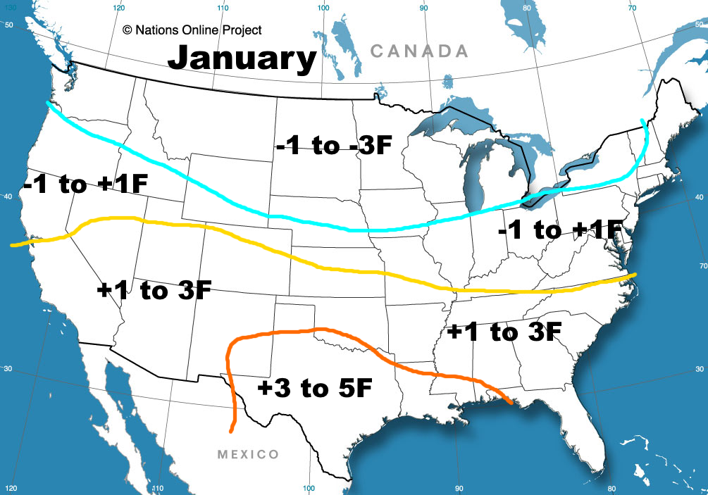
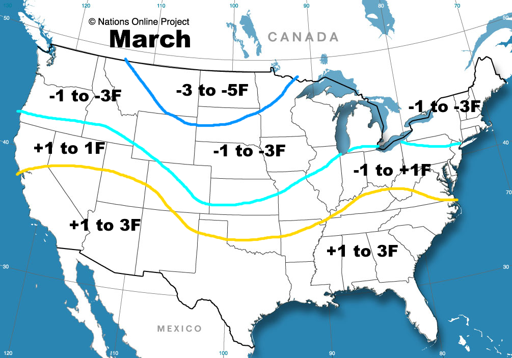
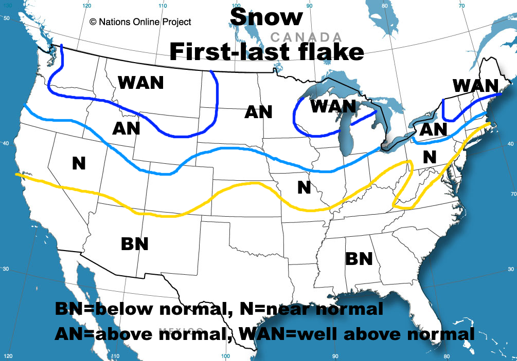
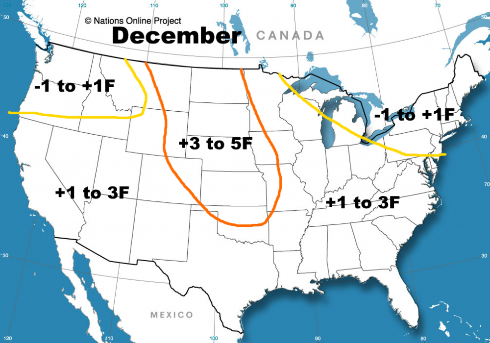
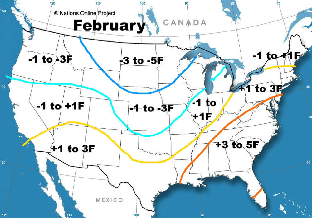
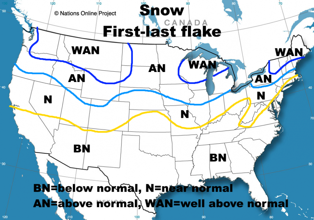
Hey all, I just wanted to pass along my winter outlook and technical write-up. I'll post the monthly maps and brief discos with each month here. The entire write-up is quite long, so I will link to the rest of it if interested (it takes too long for me to upload all of the images to do it again on each forum) December: A +PNA to end November and start December leads to a very mild / warm start to the month across the CONUS (slightly cooler over the Southeast / East Coast)…however, an active STJ and a wavier pattern than the ensemble means will show at this distance may allow for enough polar influence for an opportunity or two at a winter storm across the central or eastern U.S. Given the +PNA and active STJ, this may occur in areas such as the Ohio / Tennessee Valley, Appalachians, Southeast or Mid-Atlantic, farther south than what you may expect in a La Nina and more typical of an El Nino. A +PNA, split flow, and active STJ are features that are frequently seen in an El Nino! This window is brief, the first week or so of the month and with a questionable amount of polar air to work with, so it may not work, but there should be a bit to track on the models as this comes into range. Thereafter, the SPV moving away from Alaska, persistent +EAMT, and convection getting into the 120-150E area (and likely persisting a bit more as the GEFS has due to the lower frequency forcing in that region this fall) likely allows for a window of -EPO, and a pattern more typical of a December La Nina. I think there’s still enough momentum in the Pacific jet that this dumps into the Midwest and Northeast as opposed to the Rockies and Plains as typically occurs with EPO shots. This trends towards cold edging towards the Northwest / northern Rockies into late December, with a Southeast Ridge cropping back up due to forcing becoming more focused on the Indian Ocean, and due to Indonesian convection beginning to teleconnect to a Southeast Ridge in later December. With the start of end of December quite possibly warm for a large portion of the country, the month as a whole will be mild across the CONUS. While I think the NAO likely ends up positive for the month, if we take advantage of the potential to develop a -NAO in early or mid-December, it would up the ante for snow in the Northeast and Mid Atlantic in that window, and may slow the warm-up later in the month. Even without a -NAO, I think there are opportunities for some snow in December in the central and eastern U.S. (even the southwest may have a window with the STJ, the NW and Rockies will be active and trend colder later in the month as well). January: January may start cold in the Northwest U.S. and warm across the southern and eastern U.S. However, I think the MJO has another opportunity to propagate east during the first half of the month. I believe the PV will be weaker and more receptive to the MJO producing a blocking response than it is in early December. This may cause another period of -EPO, -NAO, and a somewhat active sub-tropical jet for a couple of weeks starting the first or second week of January. This will bring another window of winter farther southeast towards the Ohio Valley, Mid-Atlantic, and perhaps even the Southeast. I think we start trending towards a Southeast ridge later in January as the MJO fades and Indian Ocean forcing crops back up. How much blocking develops in the first half of January will of course influence how quickly this warm-up occurs. February: This is generally the warmest month in the analogs, with an amped central Pacific ridge dumping cold into Alaska, western Canada, and the northwest / north-central CONUS. If we have persistent Indian Ocean forcing and a strengthening PV to open the month, that will probably be the case again this year. If there’s cold available in Canada, the +NAO may lead to confluence east of New England that leads to high pressure over eastern Canada that can cause cold air to seep down into New England and perhaps the Great Lakes in February, causing some wintry threats in these areas…however, the pattern I envision for February is not snow-friendly in the Ohio Valley, and especially the Southeast and Mid-Atlantic. March: Cold air likely remains available in Canada, so if the MJO becomes active again in late-February or March it may shake-up the pattern enough to bring it south and bring one last shot of winter in March. If this does not occur early enough, the Southeast Ridge dominates much of March and keeps the cold over the Northwest, Plains, and Midwest / northern Great Lakes / northern New England. Seasonal Snowfall: Teleconnection Guesses: AO: Generally positive, but may go neutral or negative briefly in early-mid December, and perhaps a bit more legitimately in January NAO: Generally positive, may briefly go negative in early-mid December, with greater potential for a couple-few weeks of a variable / negative at times NAO in January PNA: Generally negative aside from early December, and perhaps another brief spike later in the season EPO: Generally somewhat positive, but will dip at times. Mid December and perhaps mid-late January may offer windows. Here is the link to the full technical write-up: https://jimsullivanweather.com/2020/11/21/jim-sullivans-2020-21-winter-outlook-write-up/


-
There are a number of limiting factors for significant accums Sunday afternoon - night, especially in NE Ohio...marginal surface temps, flow turning off the warm lake, increasingly short fetch, and strong and gradually turning winds through the event. With that said, it's an impressively cold airmass with extreme instability, enough synoptic moisture plus some upstream connections, and synoptic support from a surface trough and upper-level trough moving through Sunday evening. I expect a few W-E oriented bands to develop from Cleveland up the lakeshore through NW PA / SW NY Sunday afternoon ahead of the trough and swing south/southwest during the evening as the wind turns. One or two of these bands may be quite intense with thunder / lightning. Temperatures are marginal for snow, but these bands would likely fall as all graupel or snow, especially inland in the hills. Later in the evening and through the night, any dominant afternoon or early-evening bands will likely break into weaker NW flow multi-bands, with most bands being weak but one or two bands with upstream connections remaining more intense. NW PA downwind of Lake Huron seems most likely to see this, but there will probably be one or two somewhat weaker upstream connections in the Cleveland area that can persist through the night. Conditions become unfavorable for lake effect by Monday morning so stuff will be winding down by then. Accumulations with these types of set-ups are tricky...the terrain downwind of the lake in the primary NE OH and NW PA Snowbelt may see a quick accumulation Sunday afternoon / early evening as the dominant band swings through with the trough, perhaps a quick inch or two somewhere. Sunday night, terrain and upstream connections will be needed for any accumulations of note with a short fetch, fast flow, and marginal temperatures for accumulating snow with a flow straight off the lake. The Huron connected band will probably be intense through the night but may move enough to keep totals from getting too out of control...and any weaker upstream connections in the Cleveland area may drop some accumulation, but also will likely move a little so it'll be hard to add up. Given all of this, I think a general 2-6" in the higher terrain of NW PA is a good bet, with less closer to the lake. In NE OH I think it's more of a 1 to locally 3" overall in the terrain of both the secondary Snowbelt (SW Cuyahoga, northern Medina, parts of NW Summit Counties) as well as the primary Snowbelt (eastern Cuyahoga, southern Lake, parts of Geauga, parts of Ashtabula...the strong winds will probably push accumulating snow into parts of Portage and Trumbull as well in any bands)...and little to none along the lakeshore.
-
It actually accumulated a bit here in NW NJ too. Pretty rare in NE Ohio, borderline unprecedented here. I remember the 5/15/16 snow, was probably a bit heavier from Mayfield into northern Geauga but wasn’t as widespread as last night’s. I think we can put a wrap on this disastrous winter now.
-
There are different definitions and they've changed over time, and it's possible I'm mistaken...although if you count the reports in MD it was 400 miles anyways. Regardless, the wind from that MCS was very impressive with that measured gust of 75 at KPIT and some other reports of legitimate structural damage, and I think they'll confirm something tornadic S of Cleveland too.
-
The line that went from near Cleveland to SE of Pittsburgh was very intense and there were certainly winds in excess of 70 or 75 mph in spots...the only reason it may have fallen just short of a technical derecho is I'm not quite sure it went 400 miles (although it's fairly close at least).
-
It's overall a fairly usable model, I just haven't been able to trust it as much with convection...it did quite well here though, and did quite well in OH/PA last Saturday when many of the traditional CAMs said they'd stay dry in the warm sector during the afternoon and they didn't.
-
The HRRR and RGEM will take the wins any way they can get them with convection.
-
Heh, for once the morning convection didn't do anything it wasn't supposed to do... Definitely a few question marks remaining... Not sure on if there's initiation in time for N IL or not...the HRRR barely breaks the cap, the NAM doesn't but is close, most of the CAMs just start developing storms over NE IL before they move ESE. The frontal circulation itself should intensify a bit soon as it pushes into an area that's seen better heating over IL/SE WI, and the ascent ahead of the mid-level impulse just begins overspreading the front before it clears NE IL. I think a storm or two likely develops over N IL (like, 60/40 for one or two cells)...not really a tornado risk, but could be supercellular with a hail risk. It's a highly conditional, but perhaps locally significant hail threat. It seems that last night's models that insisted on initiation over the southern Great Lakes were on the right track, and the lack of unexpected ongoing convection certainly adds confidence in sufficient destabilization through the rest of the afternoon into the evening ahead of the cold front. The low-level flow begins to accelerate this evening, though aside from perhaps local turning ahead of the weak surface low over parts of southern MI and perhaps immediately adjacent NW OH, remains fairly veered with marginal helicity. That said, there may be enough of a combination of low LCLs and SRH in that vicinity, assuming the winds do back a bit, for a short-duration tornado risk. I can't really argue with the 5% risk as it's placed. The hail risk is fairly straight-forward initially, as the speed shear will favor mid-level updraft rotation in an environment with very steep mid-level lapse rates and fairly low wet bulb zeroes. Any discrete or semi-discrete cells will be prone to severe hail, with over 2" quite possible with any supercells. The only question is, how quickly does upscale growth occur as activity starts spreading E/SE across northern and central IN and into much of OH? This will determine when we go from an impressive hail risk to more of a wind risk. The front gradually becomes sharper this evening as the low intensifies and the front surges southeast, which favors upscale growth...and there is some large-scale ascent as the mid-level impulse/speed-max moves overhead. However, with some capping and shear vectors somewhat orthogonal to the front, it may not be immediate. While most CAMs generally show fast upscale growth, not all do immediately (in particular, the HRRR and NSSL WRF look somewhat cellular longer). There will undoubtedly be gradual upscale growth and a transition from a primarily hail threat to more of a damaging wind risk, but whether it takes a couple of hours or a few hours I'm not quite sure. I'm still curious to see if the relatively stable low-levels temper the wind risk at all. The EML will promote strong downdrafts, and upscale growth would likely result in enough clustering of those downdrafts to punch through the inversion, but most models do maintain at least some inversion tonight beneath the EML over IN/OH...especially farther NE where the surface is cooler. I'm sure an organized bowing segment would punch through it, but widespread damaging winds may be asking a lot otherwise. Definitely will be interesting to watch play out and I think the SPC outlook is fair as it is given some of the remaining uncertainty, but also the parameters that are in place.
-
Re: The Ohio afternoon stuff...can definitely see it as even the NAM soundings don't immediately build the capping inversion in this afternoon, and have a period of relatively uncapped CAPE. Could definitely see a that boundary occurring due to clouds/rain to the east and sun/warmth to the south resulting in differential heating...but, with the only source of lift being that boundary and the window for this to occur being somewhat brief before the capping inversion does spread east, think it's only a couple of storms that go with a short window to do anything. Storms would be supercellular given the shear so I could definitely see a large hail threat, but with a weak low-level flow and fairly short window think any tornado threat is still pretty low (but non-zero).
-
Coming up on midnight the night before, the road is certainly narrow at this point. It’s an infuriating decision, and sort of goes against all of the stay at home orders and business closures that have had such a profound impact already (on the spread, our daily lives and the economy)
-
There’s fairly remarkable agreement on convection initiating around 0z or so somewhere over southern MI/central or southern IL/IN/OH, growing upscale and then moving SE. How the morning convection plays out will contribute some to how far N the warm front gets into southern MI/northern OH, although with the EML advecting in I don’t think getting CAPE will be the issue...but how stable the low levels remain could be a limiting factor with northern/eastern extent. I don’t think there’s great tornado potential with a fairly weak and veered surface flow, along with good agreement on upscale growth happening fairly quickly as a shortwave approaches and encourages large-scale ascent Tuesday night...but initial cells could definitely produce hail given the EML/bulk shear, and assuming the low levels aren’t too stable there would certainly be a damaging wind risk too. Despite the EML, I think the quick upscale growth may limit the potential for more than a “slight risk” for hail (though any initial cells with mid-level rotation could produce some very large hail briefly before upscale growth occurs)...if there’s agreement on the location of an evening MCS and the low levels aren’t too stable (model soundings weaken the inversion at the base of the EML somewhat along the front in the evening as the large scale ascent improves ahead of the shortwave) I could see how the wind threat justifies a 30% somewhere, though I sort of doubt we see it out of the gate at 6z. It’s sort of an interesting setup, definitely some uncertainty so will be curious to see what can happen. We’ve gotten a couple of nice EML’s just over a week apart which is cool.
-
In Ohio a court rejected a lawsuit to push back the election, and the director of public health then issued an order that superseded that. Wonder if WI could do the same? That would be a fascinating legal exercise. It’d also help slow the spread, get out of this sooner and save lives, which this decision seems to ignore completely.
-
Looking at the dates the states in the Great Lakes took certain actions shows how behind states here were by comparison. NY and NJ shut bars, schools, and banned large gatherings around the same time the Great Lakes states did (and had orders of magnitude more cases when they did, at least in NY)...I think our stay at home order in NJ came on the 21st, so slightly earlier.
-
March 26-28 Severe Threat
OHweather replied to Tim from Springfield (IL)'s topic in Lakes/Ohio Valley
I'm not going to be sold on this going high risk until the ongoing convection is worked out. When does the ongoing elevated convection north of the warm front clear out quickly when it's on the edge of an EML and has a LLJ feeding into it? The HRRR does this and overplays the later-day threat often and there's enough uncertainty on the various CAMs WRT how the ongoing elevated convection plays out and the subsequent impact on the main threat in the afternoon to cast doubt on the HRRR. The parameter space has the potential to be high end, and if the ongoing stuff moves out and that's realized the shear vectors somewhat orthogonal to the front and fast storm motion will keep activity semi-discrete for a while...that would support a higher-end tornado threat. But they shouldn't/likely won't go high risk out of the gate at 6z. -
Not even breaking 6” in Chesterland with a 2-2.5 day W-WNW flow event is impressively bad. Drove in on 80 last night and we actually have like 0.3” where I am in Macedonia...which is relatively exciting because in February I saw 1” on 2/2 and a debatable 0.1” on 2/7 and...that’s it! Our seasonal total where I am in NW NJ is about 11”...I’m not used to their boom or bust snow climo yet for sure, and last year was mediocre as we barely squeaked out 20” (but had enough cool events that it “sufficed”)
-
Hopefully that 8" report in Solon means you guys all did well overnight.
-
This has honestly been a boring event to watch from the sidelines for the most part as it just slowly adds up...hopefully the ratios and moisture do the work tonight with WNW/NW winds favoring more widespread snow shifting inland.
-
Yeah totally agree with you about the time of year limiting organization during the day. The winds have a southerly component at MFD, CAK and YNG and have been W or WNW along the lake all day. Winds have recently gone WSW at Akron and Ravenna and are more W along the lake, so we may be seeing that trough that's been inland either weaken or shift closer to the lake. You are right that the troughs hug the lakeshore more when the temperature difference between the lake and air is greater. I feel pretty good about a band getting going later tonight east of Cleveland once we lose the diurnal influence and as the surface trough to the south either weakens or more definitively shifts north ahead of the second vort max that moves through early tomorrow...we'll see how far north that band ends up, and we'll see if we can get any organization over the next few hours before the first vort max moves through...that's where my skepticism/uncertainty is this evening. I think the best snow of the event may ultimately be tomorrow night into early Saturday with the better synoptic support and more WNW flow, making it more widespread too. The winds also weaken to more normal levels tomorrow through Saturday which will help any LES in that period. Edit: Will tack on what I posted on FB this afternoon...still mainly on track overall after last night/this morning, just removing the snow that fell last night from the board.
-
The band of "better" snow showers running through Huron, Lorain, Medina, Summit, Portage and Mahoning Counties will be a wild card this evening. It appears to be associated with a weak surface trough and is connected to Lake Michigan. I'm worried that if it stays south this evening that it limits any organization of snow showers of the primary snowbelt in NE OH and NW PA, especially with strong winds also making it harder for bands to organize. It's currently lifting north, slowly, and winds go a little more WSW the next few hours, but then gain a slight northerly component later this evening as the first vort max moves through. Whether or not that band lifts north into the Snowbelt will determine how this evening goes...usually with a W or even WSW wind would expect the surface trough to end up near the lake, but it's starting pretty far south. Based on the intensity of the snow showers the thermodynamic environment is sufficient for heavy snow if a band organizes, but we need a band to organize to see that. Later tonight the winds do gain more of a southerly component which should push the surface trough north into the primary Snowbelt by morning, so I think either way we see a band flare up east of Cleveland late tonight into Friday morning that's moderate to heavy, but whether or not there's substantial snow this evening is sort of in question. The setup still looks good for Friday evening through Saturday morning, with deeper moisture and good synoptic support likely making that less touchy than this evening.
-
Last night was on the low end of what I hoped for...not at all a bust, but the initial warm ground, blowing snow, and only a few hours of true good lake enhancement all worked against more than a few inches in the hills (a local 5-6" spot in parts of NW PA). The ongoing snow showers are decent (and under-modeled), but agree they lift north of NEOH and dta tonight as winds go W or even WSW. Erie County PA will snow (and the airport has been snowing decently for a little while), but with a strong flow I do wonder if the immediate shore gets less than progged and snow sets up a bit inland (could certainly see how it's just inland but north of Edinboro tonight, but should shift inland tomorrow night).
-
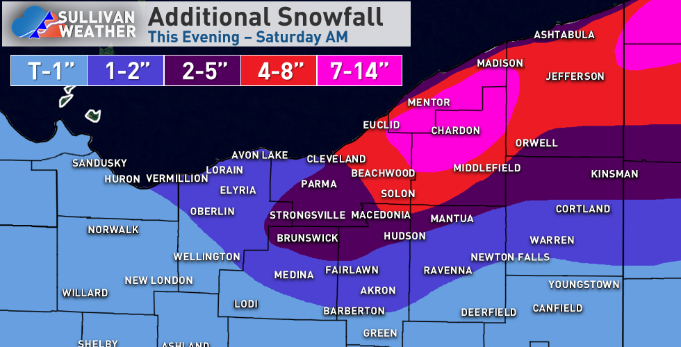
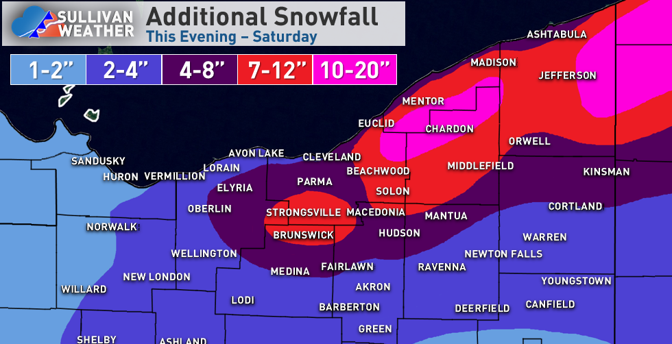
Here's a map including all snow from this evening (made around 5 PM) through the lake effect that winds down on Saturday...we'll see how it verifies: Some reasoning: My thoughts on tonight haven't changed much...the synoptic snow this evening is not that heavy or efficient, but may drop up to an inch or two in the Cleveland area and east side. Lake enhancement ramps up starting 9 or 10 PM and is most intense about 11 PM - 6 AM east of Cleveland, tapering slightly faster in the Cleveland area and secondary Snowbelt (and lingering past sunrise in NW PA). I still think the duration of the lake enhanced snow and improving ratios will allow for 4-6" in the hills of the secondary Snowbelt by morning (when including the ongoing synoptic snow) and 4-7" for most of the higher terrain east of Cleveland, with 6"+ likely in northern Geauga County and most of interior NW PA. Hi-res models continue to have 0.4-0.5" of QPF as snow in the higher terrain by morning which supports the potential for 6"+ in the most favored hills with improving ratios overnight. Winds ramp up overnight as the ratios improve so it could be a pretty wintry scene by morning. It will likely only be 2 or 3" tonight closer to the lake and in Cleveland proper, dropping off towards Sandusky where most of their snow was from the synoptic snow today with lighter snow from here on out. With a strong NW flow 2"+ totals tonight likely make it down to Mansfield, Akron and near Youngstown. There's likely a bit of a lull Thursday morning, though lake effect conditions become passable in the afternoon. Bands are likely disorganized Thursday afternoon but may drop a Coating to 2" as they go, and may start southwest of Cleveland and in the secondary Snowbelt before shifting into the primary Snowbelt towards evening. Thursday evening through Friday morning is interesting as a surface trough and vort max move through slowly, adding lift. The edge of the better synoptic moisture just grazes NE Ohio, though with a long fetch and some Lake Michigan moisture should be sufficient. Although instability and moisture both are marginal to moderate, they are well focused in the DGZ Thursday night into Friday morning, so ratios will be good. In terms of band placement, NAM guidance has a band well southwest of Cleveland Thursday evening but the RGEM lifts it into the primary Snowbelt quicker...given the westerly flow, I heavily favor the RGEM, with a few W-E oriented bands ikely from northeast Cuyahoga, Geauga and Lake through NW PA and SW NY. Given the good ratios, long fetch, and synoptic lift for a pretty long period of time I expect these bands to drop 3-6 or 4-8" type amounts Thursday evening through Friday morning on parts of the primary NE Ohio Snowbelt into NW PA and SW NY. There will be little south of Cleveland, though some snow showers and the synoptic lift could produce a local coating to 1" in the rest of NE Ohio in this window (though nothing organized outside of the primary Snowbelt). There's likely a relative lull later Friday morning into the afternoon, before a fairly deep lobe of synoptic moisture and embedded shortwave drop across Lake Erie Friday night into Saturday morning. As winds slowly shift from W to NW over the lake convergence will increase over the Snowbelt and there will be some upslope, with snow spreading south into the Cleveland area and eventually perhaps the secondary Snowbelt south of Cleveland again. Ratios again look high with a decent amount of moisture and some synoptic lift, so I think another few to locally several inches can occur Friday night into Saturday, most in the higher terrain east of Cleveland into NW PA and SW NY, but also with some snow for the Cleveland area and secondary Snowbelt. Given the multiple windows for snow and ratios, I think a widespread 10"+ is likely for the hills in the primary NE Ohio Snowbelt into NW PA, with 15-20" where bands are especially persistent. The Cleveland area and lakeshore will see less, but occasional periods of snow will gradually add up some. The secondary Snowbelt I'm debating if I went a bit too high, but if they get a few inches tonight, a little bit Thursday afternoon, and a couple inches or so Friday night into Saturday can squeak out the low end. Most of the snow west of Lorain and south of Medina, Akron and Youngstown will fall tonight, though they may see some snow showers at times Thursday through Saturday that can add additional light amounts.
-
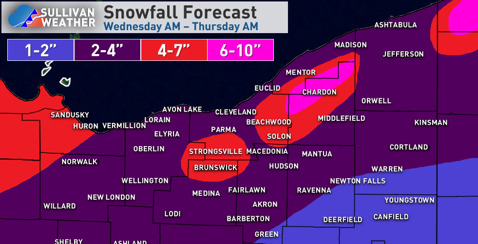
Suppose I should post this before it starts snowing... With the 850mb low track still near or just west of Sandusky into western Lake Erie, expect the heaviest synoptic snows to fall in NW Ohio. There, a long duration light snow from tonight (Tuesday night) through Wednesday evening, along with a period of moderate snow Wednesday afternoon when some modest fgen and deform ramp up will likely lead to a widespread 4 to locally 7". The rain/snow line will slowly progress southeast during the day, with the west side changing over by early-mid afternoon, and Cleveland and the Snowbelt late-afternoon or early evening. In north-central and NE Ohio there will be less synoptic snow as the weak deform band quickly swings through, thinking the synoptic snow is 1-2 or 3" in Cleveland/Akron and 2-4" on the west side...generally, the synoptic snow will be heavier closer to the lake as the best lift passes to the north. I do like the lake enhanced setup...temperatures get cold enough for lake enhancement from west to east between 8-10 PM and are quite optimal for several hours overnight with a NW flow backing towards WNW, with 700mb moisture not stripping away Cleveland points east until close to sunrise Thursday. Usually when the lake induced instability gets above the -10C level (which occurs late-evening) there will be moderate to heavy orographic lift snow in these setups in the terrain downwind of the lake until the 700mb moisture strips away. This gives a prolonged window from late evening through around sunrise Thursday of good lake enhanced snow east of Cleveland (tapers off slightly quicker south of Cleveland). My general rules of thumb in these lake enhanced scenarios (when it's cold enough, which it will be by late evening) are to take the highest QPF and assume at least a 15:1 ratio. Some hi-res models have up to half an inch of QPF as lake enhanced snow through Thursday morning, which yields potentially over half a foot. Another rule is that once it gets cold enough that rates in the higher terrain will be generally 0.5-1" per hour until the 700mb moisture strips away...given the duration (on top of the light synoptic snow in the early-mid evening) this also suggests over half a foot of lake enhancement in the prone spots. I'd like to see the hi-res stuff just a little juicier for widespread 6"+ totals, but think anyone in the hills south or east of Cleveland gets 4-7", with 6"+ being likely in the highest terrain of Geauga (and also NW PA) through Thursday morning. With wind gusts of 25-35 mph and an increasingly fluffy snow overnight, there will be blowing and drifting snow and it will be quite wintry by Thursday morning. There will be much less lake enhanced snow near the lakeshore and I'd expect the immediate lakeshore to come in on the low ends of the ranges across the board...worried about the western lakeshore missing the better synoptic snow to the west and better lake enhanced snow to to the east, so we'll see if those 4" totals can be met in northern Erie County. Otherwise, I think the terrain does fine. In terms of the additional lake effect, conditions quickly become favorable for traditional lake effect Thursday morning and afternoon, though winds go westerly (maybe even slightly S of W at times) by late Thursday through the day Friday. The lake effect will likely be moderate and accumulate efficiently Thursday afternoon into Friday morning with a long fetch and little shear, good lift and moisture in the DGZ, good synoptic support from a vort max rotating around the closed low to our northeast, and the edge of the synoptic moisture grazing Lake Erie...but, I think the heaviest snows in this period are focused near or just north of the 322 corridor in the northern Snowbelt into NW PA with a more westerly flow. Given the duration of this setup and likely high ratios, where bands persist could see another 6-10" of snow Thursday afternoon through Friday morning. There may be a lull Friday afternoon as we briefly get into some synoptic-scale sinking motion, but conditions become favorable again Friday night into Saturday morning. A lobe of deep moisture and a good vort max move through, with winds slowly shifting from W to NW. I think this is more of a lake enhanced setup with weaker instability but abundant moisture and some lift, but good snow growth given the temperature profiles. Winds will favor broad convergence over the Cleveland area and Snowbelt which will help focus snow, and orographic lift will help too. Given the decent duration and likely good ratios, this likely supports another 4-8" type accumulation from eastern Cuyahoga County into southern Lake, most of Geauga, inland Ashtabula and the higher terrain in NW PA Friday night into Saturday morning. Some accumulations likely get into the secondary Snowbelt south of Cleveland by Saturday morning as winds go more NW. The lake effect likely winds down on Saturday as ridging builds in...time permitting I'll post a map for just the lake effect Thursday afternoon-Saturday on Wednesday.
-
Definitely an interesting few days coming up (if you want snow still) The wrap around/lake enhanced snow Wednesday night looks like a general 1-3" for the Cleveland area, but could see 2-4 or 3-6" in the higher terrain due to lake enhancement. NW OH likely sees heavier synoptic snow as it looks. There will be off an on lake effect Thursday afternoon through Sunday morning...the flow through Friday may be pretty westerly or even WSW at times, but Friday night into the weekend we will see a more WNW or even NW flow. Instability looks sufficient with a lot of moisture, so there should be enough additional lake effect for advisories and maybe even some warnings late Thursday into the weekend...though as always we'll need to watch the wind direction.