OHweather
-
Posts
4,957 -
Joined
-
Last visited
Content Type
Profiles
Blogs
Forums
American Weather
Media Demo
Store
Gallery
Everything posted by OHweather
-
Some Thoughts on the Winter 2021-22 Outlook
OHweather replied to OHweather's topic in Weather Forecasting and Discussion
My thought is that there's blocking early, probably peaking in December, and then it backs off a bit through January and into February with the cold shifting northwest and more of a gradient pattern setting up as the SE ridge flexes. So I think it is cold early in the GL/OV and then is milder mid-winter. Snow may depend on where you are...up in Wisconsin it may be most active when the blocking relaxes, whereas farther south gets more of their snow when it's colder with more blocking. I think by November we'll have a decent idea on if the early blocking idea will pan out or not. There is an element of "could go either way" still this early. -
I like a winter with a fair amount of blocking (I think it'll average -AO overall) but also a somewhat -PNA. It's a La Nina so it'll be polar stream dominant and that'd be a chilly, active look for the sub-forum if correct.
-
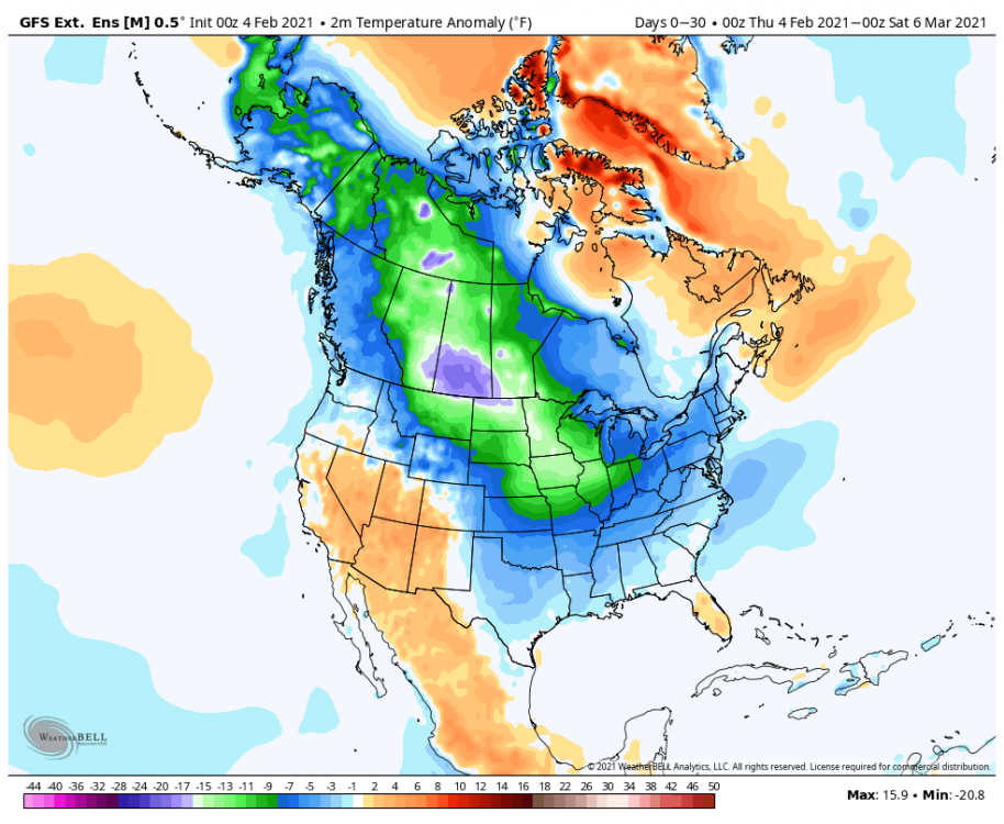
It’s still a little early on in the game, but we’re getting to the point where we can start narrowing down what various “pattern drivers” may look like this winter and examine analogs and even some seasonal forecast guidance for clues. For those who just want the maps, here are my current thoughts on temperature and precip through the winter. I’m lumping March into winter because it’s a month that can still prove to be productive for snow for many areas, and because many analogs are chilly in March. The detailed write-up with reasoning, analogs, and a look at longer range seasonal models is at the linked blog post (I'm exhausted from uploading the images on there, so I'm only going to upload a part of the post here). I hope to follow up with more focused thoughts in November, time permitting… My guesses on teleconnections: AO: Solidly negative. NAO: Near neutral or slightly negative overall, possibly large swings EPO: Near neutral or slightly negative overall. PNA: Negative, especially later in winter A stronger or more central-Pacific La Nina could pose warmer risks, especially in the central and eastern U.S., as would a strong stratospheric PV early in the winter that’s coupled to the troposphere. A quick increase in sunspots could also be a warmer risk. If forcing ends up more focused farther west into the Indian Ocean it’d likely point to a warmer winter. The La Nina staying weak to moderate and more basin-wide would point to a chillier outcome with more blocking being more likely. A weaker stratospheric polar vortex early in the winter, and tropospheric blocking developing in November, would also point towards a chillier / blockier outcome. Scandinavian or Ural ridging in October or November would also point towards a chillier and blockier direction, as would sufficient tropical forcing occurring east into the Pacific at times. I expect a very up and down winter, with very cold air frequently available over Canada that occasionally works south into much of the central and eastern CONUS this winter, along with the Northwest. The Southwest will generally be milder with a somewhat weak sub-tropical jet. The southern Plains, Gulf Coast, Southeast and lower mid-Atlantic will probably lean mild due to sharp warm-ups when blocking relaxes and / or the PNA shifts negative, though a couple of periods of EPO-induced cold all the way to the coast are possible. The most persistent cold will be in the northern Rockies and Upper Midwest. The analogs really like the first part of winter (December into January, possibly starting to turn colder in November) for blocking and cold into the central and eastern US (with cold focused more on the northwest in February). The analogs have a -EPO, -NAO, and -PNA pattern in March. I’m optimistic about snow in the northern Rockies and Pacific Northwest, along with from the Great Lakes and Ohio / Tennessee Valleys into much of the Northeast and New England. Along I-95 from Baltimore to DC and Richmond, events will be rainy at times when blocking relaxes so snow will struggle to reach or exceed normal, though there should be opportunities for wintry weather when blocking is strong enough to suppress the Southeast Ridge. I do want to post some maps based on the analogs I'm currently rolling with... And FWIW, the analog pattern for October is pretty close to what's modeled this year: Anyways, the rest of the write-up and a closer examination of the analogs is here: https://jimsullivanweather.com/2021/10/04/an-exploration-of-cool-enso-winters-and-a-look-at-winter-2021-22/

- 89 replies
-
- 10
-

-

-
I agree with you on the AO. But if anything that analog highlights...E QBO La Ninas tend to have a somewhat flatter N Pacific ridge than W QBO La Ninas, which does open the risk for the PV to sink into Alaska. So, it's a concern. There is at least some signal for a -NAO on analogs and models, so I do have some cautious optimism as long as the Pacific can behave. That year does have some interesting ENSO and QBO similarities to this year. There are other things (Atlantic SSTs and off-equator SSTs, along with summer tropical forcing) that differ from this year and kind of turn me off to it as an analog, but the winter look is somewhat similar to other years that I'm playing with WRT ridging probably centered W of Alaska with a -NAO.
-
Agree, when looking for analogs, unless it's an exceptionally strong event, I'll usually allow expected ENSO state plus or minus one (i.e. at the moment I'm playing with analogs ranging from cool neutral to moderate La Nina). I'll also heavily weigh things like QBO, whether an ENSO event is west or east weighted, the Indian Ocean Dipole and where lower-frequency tropical forcing is in the months leading into winter. So this year I'm playing with cool ENSO - moderate La Ninas, and looking (if possible) for ones with an easterly QBO, a negative IOD and a warm west Pac. Also, the lower frequency forcing this summer so far has been most favored over the western Pacific. It's an interesting set of analogs, with years like 74-75, 00-01, 05-06, 12-13 and 17-18 showing up in there, but also a disaster like 11-12 hitting many of those too.
-
Just to go on the record, I tend to agree that this La Nina will be slightly weaker than last year's given the surface is running noticeably warmer, though it's quite possible August's sub-surface anomaly is around -1, which would put it pretty close to last year's sub-surface "peak"...my argument is that at least a weak La Nina is likely, nothing too much more.
-
Nicce
-
Apparently the 0z ILN sounding had a +3C warm nose, which is a good 2C warmer than even those brave, sleety NAM runs yesterday.
-
Unfortunately would've liked to have seen the all snow line collapse a little farther SE over the last couple hours than it did. There's one more opportunity to flip before the dry slot with the slug coming into southern OH right now, especially for Dayton and Columbus, but I think everyone knows what their fate is. Accumulating sleet does count towards your seasonal snow total and it'll still wreck the roads, not that that's much consolation.
-
You won't get significant ice that far west, but you'll probably get more sleet than you want.
-
The ongoing mix will flip to snow in Cincinnati and Columbus as lift and rates improve over the next few hours (before probably going back to a mix this evening) so you'll still get some snow, but I-71 is definitely going to end up well within the gradient in totals with max amounts well to the west.
-
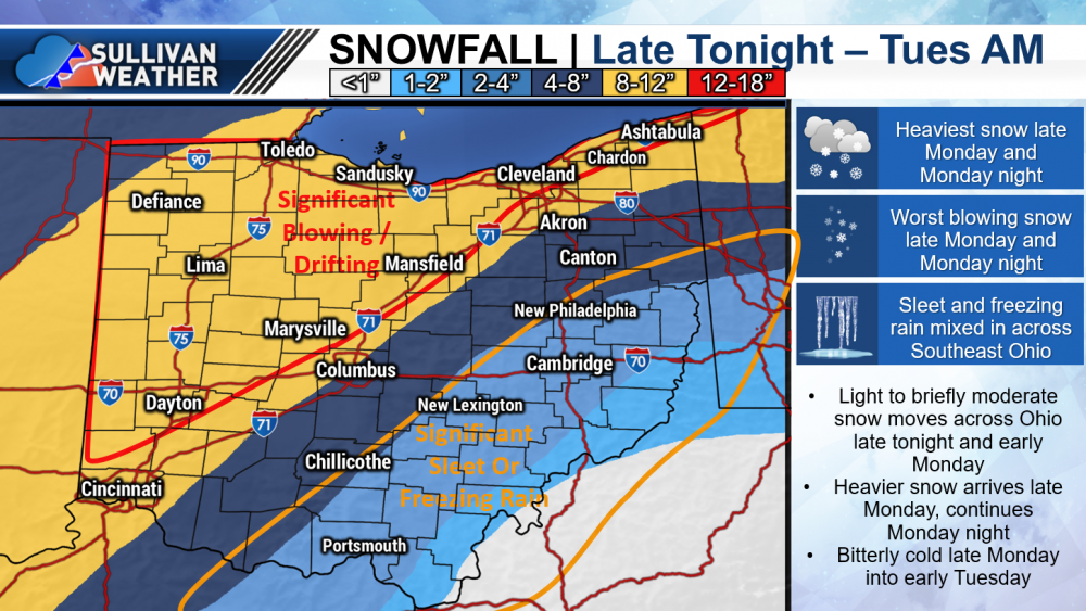
Iff I had to give numbers: CMH: 7.7" DAY: 12.5" CVG: 10.8" TOL: 11.4" CLE: 10.2"
-
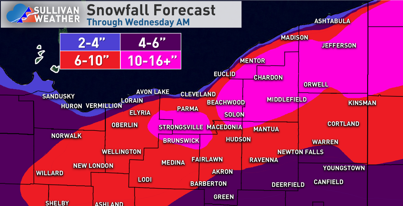
I think 8-12" is good for the Cleveland area, may be a tad more if some lake-enhancement occurs in Cuyahoga County or points west with a NNE flow. With an 850mb low track near or just east of I-71 I do think the heaviest axis ends up solidly west of that corridor, and could see Akron getting a bit less than Cleveland and Youngstown getting several inches less and trying to sleet or dry slot. This will be another solid storm for the Cleveland area in a winter that's seen a few already.
-
I think the NAM (especially the 12z) was a bit too stingy farther east, but with an 850mb low track up or just a tad east of I-71, I'd expect the heaviest swath to end up solidly west of I-71 and I'd also expect it to sleet / dry slot farther north than people want. Could see localized max amounts over a foot in west-central or NW OH, and where it is all snow Monday night it will be downright nasty with gusty winds, falling temperatures and moderate-heavy snow. Here's my guess...definitely hedged a bit NW, but there is bust potential either way along that gradient.
-
Winter 2020-21 Medium/Long Range Discussion
OHweather replied to Hoosier's topic in Lakes/Ohio Valley
After the PV starts lifting out next week, there may be an opportunity for clippers if heights can rise on the west coast around mid February. -
Winter 2020-21 Medium/Long Range Discussion
OHweather replied to Hoosier's topic in Lakes/Ohio Valley
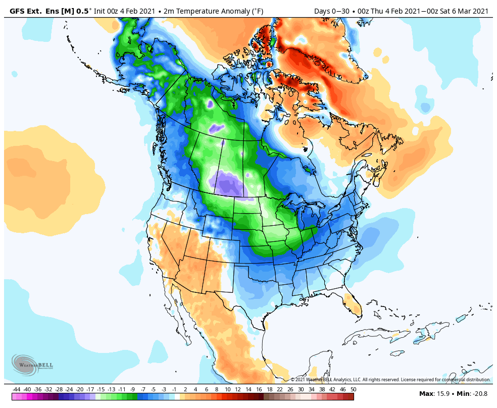
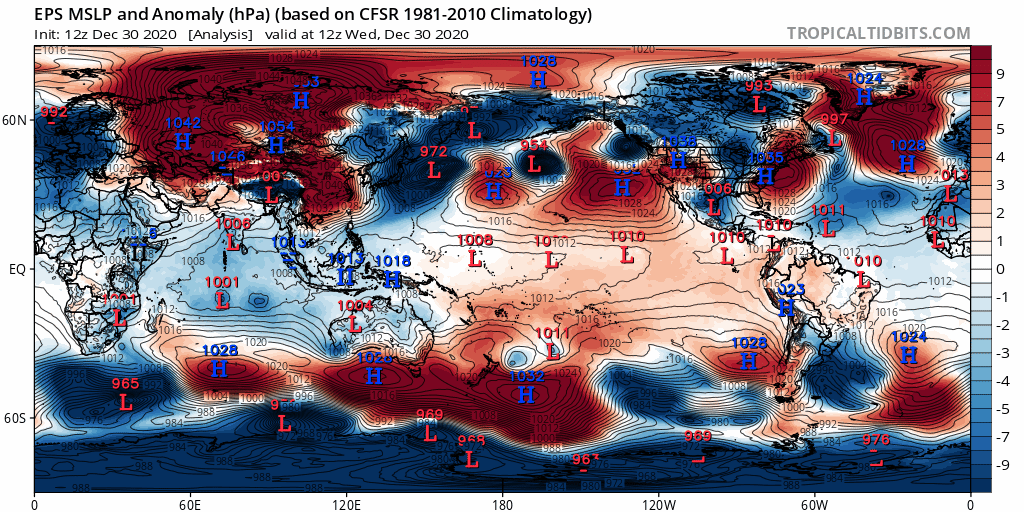
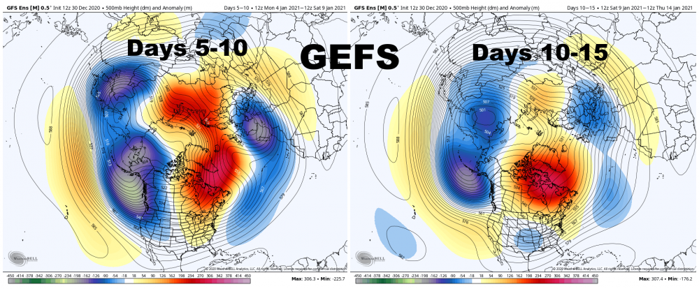
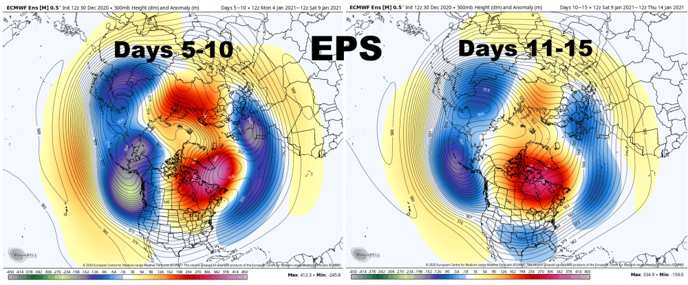
The pattern coming up is going to feature plenty of cold / Arctic air over North America to tap, along with a continued tendency for blocking over the Atlantic. A Rossby wave making machine will be in place over the western Pacific, encouraging persistent north Pacific blocking and a cross polar flow into Canada. This is occurring while a tendency for high latitude blocking continues across the board for multiple reasons. This loop of the GFS helps show the continued cross polar flow into Canada, and how the retrograding -NAO helps shove the tropospheric polar vortex towards the CONUS this weekend and next week, bringing a cold snap to much of the Lower 48. With the Pacific blocking likely continuing for the forseeable future, the model shows Arctic air reloading towards the end of the run in mid-late February. One of the reasons we will remain "blocky" for the forseeable future is the continued downwelling of the weakened stratospheric polar vortex into the troposphere, which encourages a -AO and blocking: On top of that, there's been a recent uptick in tropical forcing across the western hemisphere, and western Pacific forcing will continue until further notice: This deposits momentum in the tropics and subtropics (enhances the sub-tropical jet). Because momentum is a conserved quantity, the increase in momentum in the tropics and subtropics results in a decrease in momentum in the higher-latitudes, which causes a tendency for blocking. The 12z GFS is shown as an example of this, note how the stronger sub-tropical jets over the eastern Pacific and eastern Atlantic occur beneath weaker higher-latitude flow, and how this encourages high latitude blocking: The persistent western Pacific forcing will keep our Pacific blocking in place for most of February, and the Arctic air dropping into North America will encourage continued cyclogenesis near the east coast, which will help encourage Atlantic blocking as well. Basically, the US will lean cold for much of February. There will be a baroclinic zone across the southern / eastern US, though the cold will seep south and east at times given the -NAO and the quality of the cold that will be available. The Arctic air may lead to near to below average precipitation for a lot of the CONUS (save for perhaps the southeast/east coast), but the pattern will stay at least somewhat active given the baroclinic zone and hints of a subtropical jet. The GEFS and EPS weekly forecasts for the next 30 days speak for themselves: While suppression and lack of moisture may be a problem at times, we are already in a rather wintry stretch that will probably last through all of February, and perhaps into early March..gif.708c963f1c23494fb7b28727d57c4ff3.gif)
.thumb.gif.f80deebf3a22b6fd29577a3af992142d.gif)
.thumb.png.df8a2bac7b354432faec6eb8dc6d2534.png)
.thumb.gif.56c98fdb93a70accba8d5a7f932625b3.gif)
-
Winter 2020-21 Medium/Long Range Discussion
OHweather replied to Hoosier's topic in Lakes/Ohio Valley
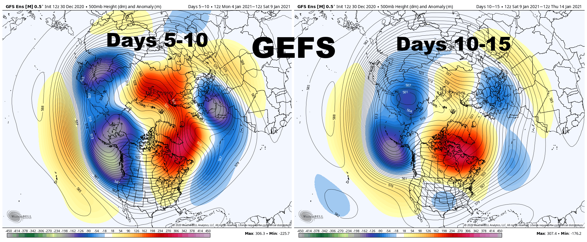
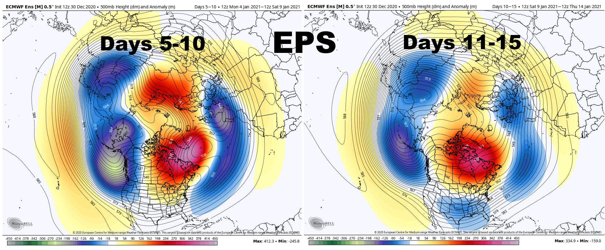
The very strong positive East Asian Mountain Torque (the very strong high pressure over eastern Asia) which is causing our strong Pacific jet stream and flood of mild air, but is also contributing to the developing strat warming event, is hinted to begin weakening in the the 7-10 day: This causes the trough to begin retrograding across the northern Pacific as the Pacific jet begins to pull back a bit. As a result, both the GEFS and EPS begin raising heights in the 10-15 day range on the West Coast of the US and Canada: With an active sub-tropical jet and developing split flow over the western U.S., along with a persistent, west-based -NAO, this would begin increasing the risk for winter storms across the eastern and central U.S. around or just after January 10th. It would not immediately be a very cold pattern, but it could be a snowy one for some areas. The EPS continues to retrograde the trough into northeast Asia in the 10-15 day range while the Pacific jet continues pulling back. I'm not sure this lasts long, but could give a window for ridging into Alaska after mid-month. With a split flow over the western US and continued -NAO, a window of ridging over Alaska could both introduce colder air, but also lead to a quite active pattern for the Ohio Valley and southern Great Lakes into the Northeast beginning around or just after the middle of January. This is still a long way's out, but signs point to a better Pacific pattern soon. Given the -NAO in place slowing down any storms over the eastern 2/3rds of the CONUS, all we need is a somewhat cooperative Pacific to have some fun.
.gif.de6b65be41887373a5f8da892c5f0858.gif)
-
Somehow fluffed out about 2 more inches last night. Roughly 13” total, with much more to my north. Another awesome event this season, glad I was in town for it!
-
Up to 11.2”. Has been quite light for a few hours until recently but never stopped after we flipped around 2pm yesterday.
-
A little over 10” here so far, maybe will get another fluffy inch or so through the evening with more to my north. This stuff falling right now is incredibly high ratio I’m sure it’s 30-40:1.
-
The timing of this one is working out great for sure. Of all the times I came in for a weekend or over the holidays the last two winters we never snowed more than an inch...coming off of the 9” I got from the “big storm” in NJ last week a nice little stretch!
-
Just got to Reminderville, good timing. Should be a good 6-8” here and 8-12” for the NEOH/Dta area, and maybe a bit higher along and just north of route 6. 0z models have stopped the bleeding and ticked back west.
-
The radar has lit up noticeably over the last couple of hours as some better synoptic lift has dropped across the lake. Cams also show much larger flakes, so snow growth appears to finally be better and I'm guessing away from the immediate lake ratios are probably somewhere in the 12-15:1 range. The lift doesn't go away for several more hours so you'll really stack it thick from eastern Lorain County points east the rest of the day.
-
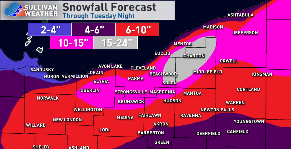
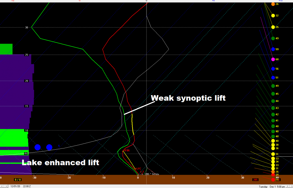
No big changes overall to NE OH for this, other than to add in the 15-24" area that I should've just added yesterday! The duration and likely intensity are both up there. There's enough synoptic lift to support light to at times moderate snow on its own from this evening through Tuesday afternoon as the closed low stalls to the east-northeast. On top of that, it's cold enough for borderline moderate lake-induced CAPE with lake to 850mb temp differentials of 15-18C overnight tonight through Tuesday evening and EL heights of 7-8k feet and obviously, plenty of moisture and lift. There will be a broad cyclonic and convergent flow, which the lakeshore will help augment, and probably some upstream help from Lake MI as well Tuesday into Tuesday night. Ratios tonight will likely be less than 10:1 due to lift focused below the DGZ and initially mild temperatures, but should actually fluff out a good bit on Tuesday away from the lake as the DGZ lowers into the area of lift and deepens considerably. My guess is that from Lorain and Medina Counties east it just rips, consistently near or over 1" per hour, especially in the hills, from later this evening through Tuesday evening. The timing will be slightly later to the east. There's good synoptic lift and a much better lake-induced component than usual for an enhancement event. I don't think we've had a lake enhanced set-up this prolonged and intense since the winter of 2010-11. The greatest lake enhancement will focus on Lorain, Medina, Cuyahoga, Summit, and western Geauga tonight into early Tuesday and then gradually shift into the primary Snowbelt Tuesday into Tuesday evening, before ending by early Wednesday. Widespread totals of near or over a foot seem exceedingly likely away from the immediate lakeshore for a long swath, with max amounts pushing or exceeding 2 feet...most likely in the higher terrain in eastern Cuyahoga and Geauga County, though there may be a small spot in southwestern Cuyahoga, eastern Lorain, or northern Medina that also goes over 15", though I didn't explicitly draw it in. My opinion is these totals may be a bit too low across the board given hi-res model agreement on 1.50-2.50" of QPF as snow from the Cleveland metro points east, but wasn't sure exactly how high I wanted to go (plus I was out of colors). I don't have a great feel for the immediate lakeshore with this. It will be significantly less than in the hills, but the winds may go offshore enough later in the event for some accumulation to the water. The significant amount of snow, initially wet nature, and gusty winds will really make travel difficult...and there will probably be some power outages due to the initially heavy, wet nature of the snow and gusty winds. I'm definitely a bit jealous I'm missing this one!
-
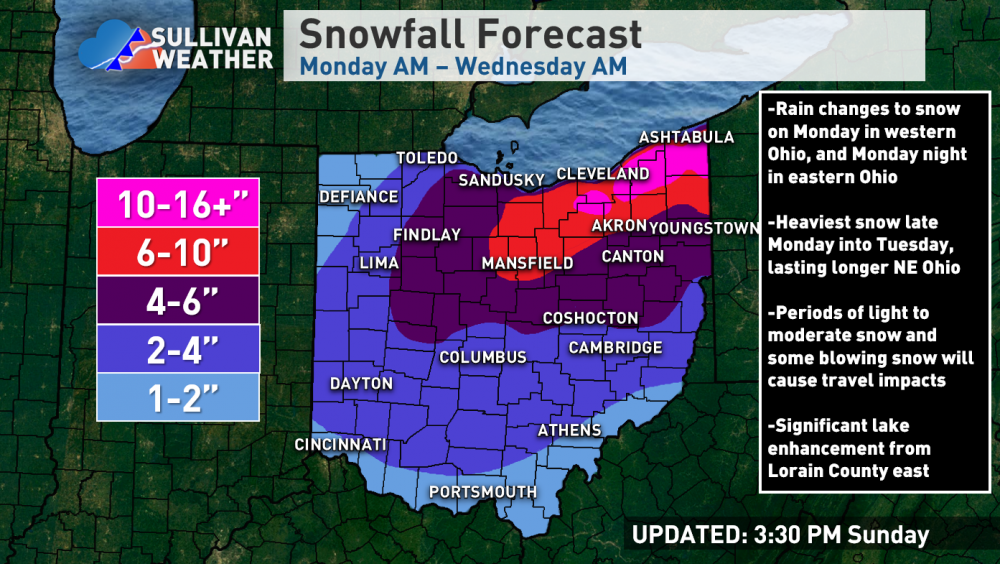
Here are the overly colorful maps I posted on FB this afternoon: In general, rain changes to snow on Monday in western and into north-central OH, and in NE Ohio Monday evening. The synoptic lift is moderate across western OH for much of Monday, with the main lift shifting to over Lake Erie and adjacent northern / eastern Ohio Monday night through Tuesday (with just weaker lift farther south / west by this part of the storm). The lift slowly pulls to the east Tuesday night. Lake to 850mb temp differentials exceed 13C Monday evening and grow to over 15C overnight, staying at around 15C or slightly greater through Tuesday night, with inversion heights climbing to around 7k feet Monday night and staying there through Tuesday evening before diminishing. The flow is more NNW to NW Monday night and fairly strong, so the lake enhancement will focus from the secondary Snowbelt south/southwest of Cleveland into the higher terrain of Geauga County. There won't be organized bands, but a general area of better rates focused on the higher terrain of the secondary Snowbelt and western primary Snowbelt. On Tuesday the flow gradually weakens a bit and veers to WNW and eventually W through the day. The weaker flow, longer fetch, and increasing convergence from Cuyahoga County points east may allow for a more organized area of heavy lake enhancement Tuesday into Tuesday evening, that gradually works east Tuesday night into Wednesday morning as the storm slowly pulls away. The synoptic snow won't be that impressive, but should still yield 2-4" for much of the state given the duration, even if it's not very exciting. In northern and eastern OH where the synoptic lift lasts the longest, 4-6" should fall, but again it will be rather spread out. In the central highlands near MFD, upslope and the prolonged nature of the event should give a boost to totals, with 6" or so possible. Elsewhere, the secondary and primary Snowbelt will see a prolonged period of moderate to heavy snow, and ratios should actually be OK Tuesday into Tuesday night, especially in the hills. Over a foot of snow is quite likely in the higher terrain, including Erie County PA, with max amounts possibly pushing 20" somewhere in eastern Cuyahoga or northern Geauga. This attached NAM sounding from the east side for Tuesday evening is classic, with enough weak synoptic lift for snow, and a healthy layer of instability and lift in the low-levels due to the lake enhancement. It could be colder for ideal ratios, but once surface temperatures drop below freezing ratios should be a little better than 10:1. The lakeshore is tough...my guess is the winds go close enough to offshore late in the event for some accumulation, but more than a couple-few slushy inches seems like a stretch...with a very quick increase inland.


.gif.b53ad62691a1cd1343f99d38f396af99.gif)
.png.085e9a01c0c5f2a8222975b37bcccef5.png)
.gif.9d381a2ff48fe86ce9da5b66b65f1f91.gif)