

OHweather
-
Posts
4,957 -
Joined
-
Last visited
Content Type
Profiles
Blogs
Forums
American Weather
Media Demo
Store
Gallery
Everything posted by OHweather
-
If we’re being honest here it’s possible the 18z GGEM and ICON aren’t the most confidence-inspiring duo.
-
Not sure if there was collaboration on that or not, but these insane numbers rarely pan out as modeled, plus track will change, so here we are trying to be aggressive enough to get people to stay tuned to the forecast but vague enough to not put amounts in anyone’s heads yet. Once models show all time record snow storms and a ton of ice it’s hard to stop that hype train from getting into the public sphere but we can try to at least steer the message…try the key word.
-
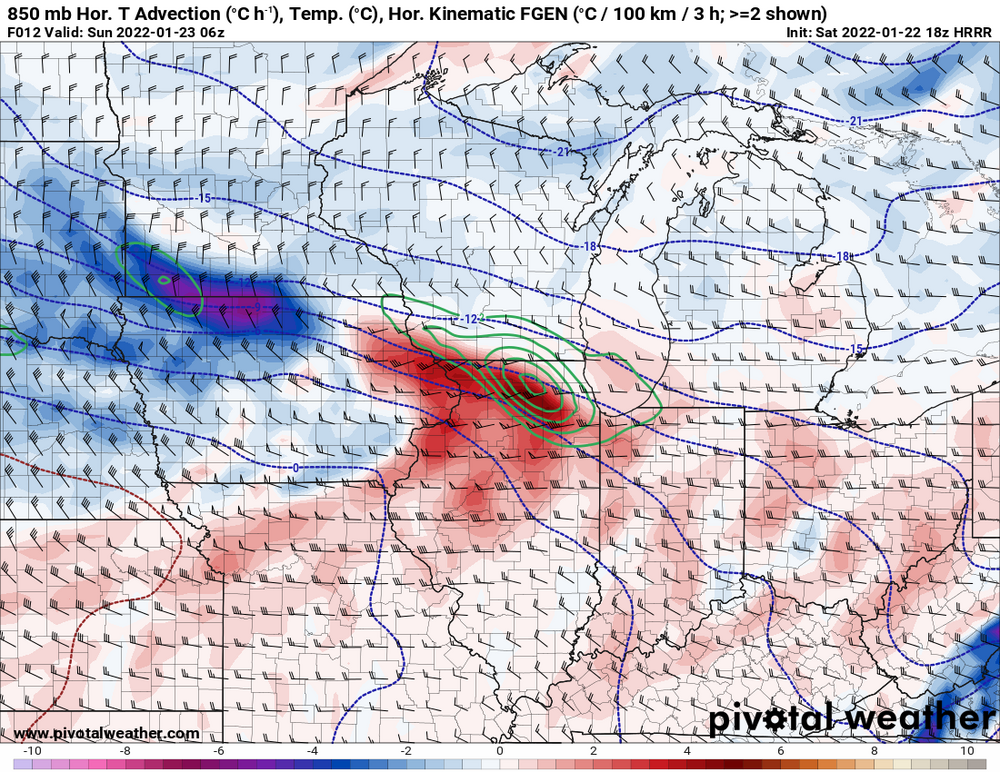
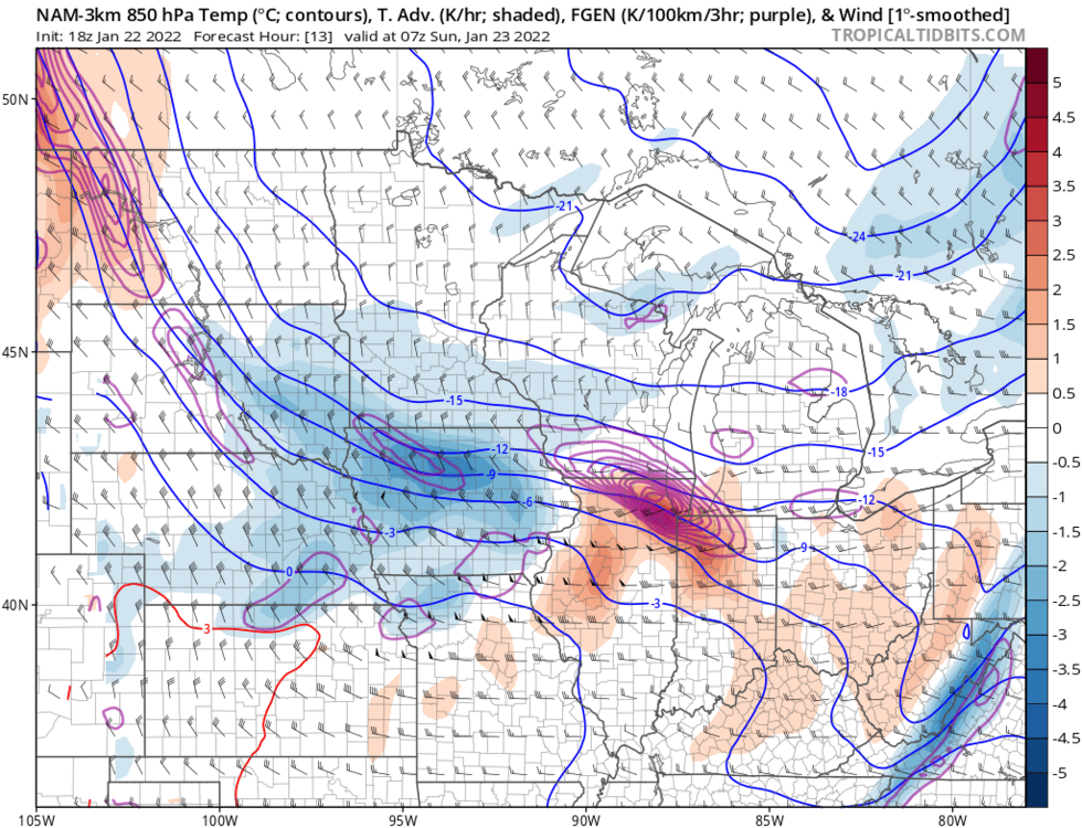
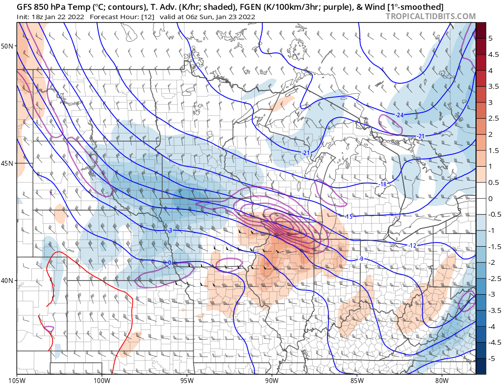
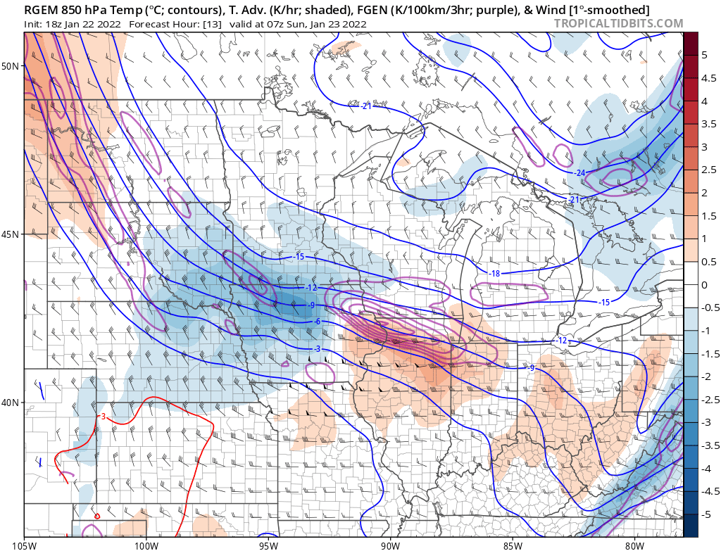
Leaned a little more amped in the forecast idea here at CLE today…suspect we may inch the IP/ZR a bit farther N with time but as a start have it for the southeastern 2/3rds of the CWA…not quite to Cleveland yet but suspect it gets there. Snow grids don’t go out through the whole storm yet here with the heaviest in OH being Thursday so the grids only mean so much for now here. Like the 12/18z GFS, 0z CMC, 12z Euro as a start for rough conceptual ideas and adjust from there. Feel like PV adjustments noted on the Euro yesterday that led to the SE bump have stopped today. Feel that with a ridge off the west coast and SE ridge/+NAO that a system heavily driven by WAA like this will want to edge a bit more amped and NW unless that PV just shears out the wave more…currently seems unlikely but that’s what to watch if you want a colder trend.
-
Had the AFD and grids today. Suspect it’s a sleet fest near or just south of Cleveland (with 12-24” of snow just north of the sleet) and a lot of ice in Canton and down towards central and SW Ohio. Feel the more consolidated and amped models are the way to lean…sort of liked a mix of the 12z/18z GFS, 0z CMC and 12z euro as a start for a conceptual idea…and go from there. Fear it trends a little more north from where we are now.
-
Definitely has been fun to be on the forecast desk the last few days, and a good learning experience...we'll see how things trend the next couple of days. Tried to leave things as open ended as possible today and just give comments on what would happen if we saw the snowier or wetter solution pan out.
-
The 0z NAM would definitely be GFS-y if ran out a little further. For whatever it's worth.
-
I honestly don't know then. If it was that many, would have to assume it would've been investigated and would say it's relatively shameful if it wasn't. Or perhaps that figure is using data that hasn't been updated recently. With snowfall and tornado climatology and records I've come to realize that we "do the best we can" (in most instances) but that there's too many variables involved for them to be more than rough approximations...sadly.
-
It may be up to the state climatologist and / or local NWS offices to submit possible records for verification as well. In NJ last winter someone measured more than the state record by a couple of inches in their backyard in a huge Nor'easter we got. Mt Holly put it in their PNS and the state climatologist did investigate it. The end result was snow blowing off a roof may have inflated the total so it was tossed. Then again the state climatologist also thinks the NJ state record (that is like 100 years) wasn't properly measured either so who knows with some of these things.
-
That's an interesting comparison. I do remember the last second NW trend with that one. We were initially slated to get snow here in Cleveland...and the GFS tried holding on until about 18 hours out...we got mainly rain (as you'd expect with an SLP track right over our heads) and ended as a bit of wind whipped snow as the Arctic air poured in. Interesting comp to this one because it was also a fairly low amplitude shortwave with Arctic air behind it. If the GEFS/GFS is correct and the PV exerts less influence we could see similar trends with this one given how warm and how much ridging there will be over the eastern US in front of it. I do feel that the PV being located farther east over Canada in this case and higher heights over the Plains will prevent as meridional of a track in this case, but if the PV influence is weaker then the Euro is in all likelihood too far south at the moment.
-
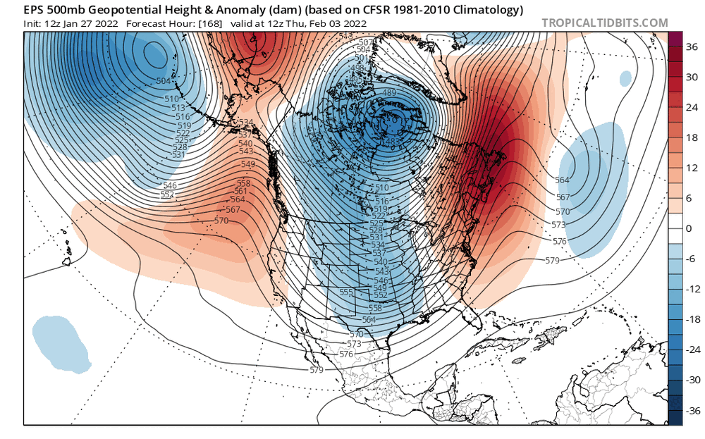
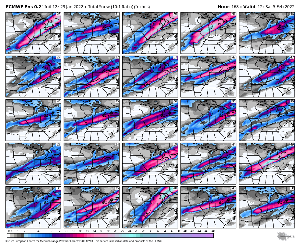
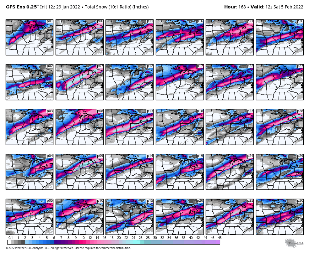
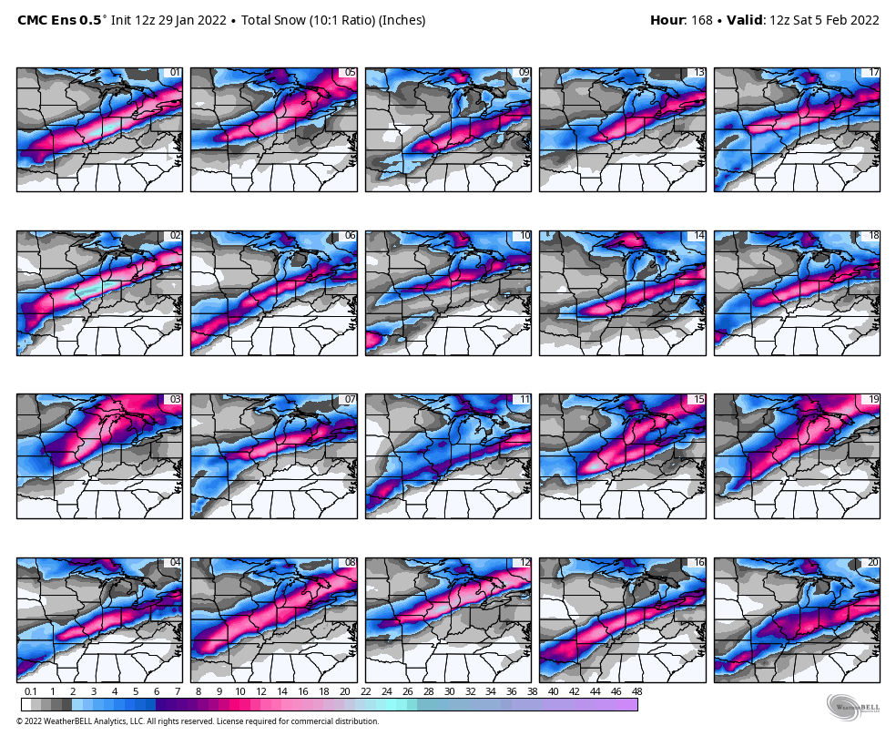
I honestly don't have a great feel at the moment for which way this ultimately trends either way. Pretty interesting that the GFS and GEFS are holding amped (and if anything the GEFS have trended a bit more amped today) and the Euro and EPS are going the other way. The GFS and GEFS have been competitive with the Europeans the last couple of winters. Gut feeling with a +NAO and ridge axis off the west coast would be a NW trend. That may still play out here. But, here's what the EPS is doing at 500mb over the last 3 days worth of 12z runs... Trending towards the PV near Hudson Bay exerting more influence, with a lobe of it extending towards the Upper Great Lakes. On top of that, it's ejecting the shortwave out of the Four Corners a little slower...though, is that just EPS bias? Now here are the GEFS trends over the last number of runs: It has trended towards ejecting the shortwave a little slower, but is trending towards the PV over Canada exerting LESS influence. Feel like the trend to eject the trough slower is legitimate, and that would argue for a somewhat flatter solution IF the PV over Canada exerts more influence. We need to watch trends in both aspects, but the PV influence seems to be causing these big differences. At this point I have no clue. A worst case scenario would be the PV pressing down but a fairly amplified trough still ejecting, as that's where you get the GFS solution with stronger WAA aloft as the surface stays cold, meaning someone gets a lot of that QPF as ice.
.thumb.gif.0950177be1ee6ec5974923e2bd2f5d73.gif)
-
Edit: ninja’d Here are all the 12z ensemble individual members. Euro is definitely a southern outlier though has modest support. Feel with such a tight compressed height gradient that if this ejects slower or not enough at once that progressive/SE isn’t unreasonable, but if it amps at all it’ll try cutting until it runs into the PV west or SW of Hudson Bay. With the overrunning ahead of the storm, strong gradient resulting in plenty of jet support, and deep feed of moisture high QPF is a very good bet…and a zone of icing is likely. At a certain point if this trends way more progressive the QPF and ceiling would become less impressive but there’s minimal ensemble support towards something like the 12z UKMET for now. UKMET is trash anymore anyways.

-
I'll hopefully be on the AFD and long term grids again today. An impactful system looks quite likely. Wouldn't rule out it inching back north, though the overall trend the last 2-3 days has been to sink the system a little farther south. Plenty of moisture to work with so I think warning criteria wintry impacts are almost a slam dunk, question is where that sets up though. A straight rain to snow transition seems unlikely too so some ice and sleet are probably in play somewhere. If the rainy side of the system impacts areas with a deep snow pack that could cause flooding issues too.
-
Yeah this snow made for a fun morning commute. Had 1.5" in Reminderville when I left but it was snow still good, estimated 2" driving up through Solon. Still snowing good now with a little flare-up of lake enhancement in and around the Cleveland area, may squeeze out another inch or so in spots which will push a few locations to 3 or 4" of snow. Next week is tricky...a stronger, consolidated low pressure would want to cut. But some models and ensemble members have weaker frontal waves as the Arctic front sags south and have a lot of QPF as snow or ice for northern OH. Let's see if we can reel another one in...
-
It does seem the snow moved through on the quick side...we may or may not have gotten to 2" here (I haven't measured and probably won't today), though it's close. Already some light freezing rain / mist being reported in north-central and northwest OH, hoping the snow and treatment for it that we got today prevents issues with that as it's quite cold with temps in the mid 20s.
-
It is yes. It's not a great set-up, but there should be an uptick for several hours late tonight into early tomorrow and there will likely be some light accumulations in the Cleveland area and Snowbelt. Tomorrow night into Wednesday morning is actually a pretty good looking set-up for the primary snowbelt with a W or WNW flow and I think it'd easily be an advisory to warning event for Lake and northern Geauga on east, but we'll see if there's sufficient moisture flux through the increasing ice on the lake for that. There will be some LES either way, but I'm not sure if the ice will keep it in check. Seems like a pretty good set-up with a decently high inversion, light and well-aligned flow, and a good amount of moisture from Lake Michigan.
-
Solid light snow (but with smallish flakes) here right now too, started in the last half hour or so. If it does this until 7 or 8 PM and we grind out 2 or 3" I'd take it. Just adding to the pack at this point.
-
What kind of quality is the snow out there? Findlay and Toledo are reporting 1/2 to 3/4 mile visibility which is pretty decent, are the flakes the bigger ones that can stack up quicker?
-
Radar looks good for several hours of steady light to moderate snow across all of northern OH with this clipper today. I feel a little more optimistic, feel like 2-3" amounts will be more common than 1" amounts. I don't think it'll snow hard enough to get too much more but it's looking like a solid little event.
-
Enough lift for a quick shot of moderate snow. I like 1-3" for most of northern and central OH, though feel 1-2" is more common than 3" since it's quick moving and the lift is noticeably weaker than today's system. However, it'll briefly snow pretty decent from west to east late morning into the afternoon. Could be a freezing drizzle concern Monday evening across Ohio as the low-levels look moist ahead of a cold front but the mid-levels will be dry.
-
Got 4.5-5” of fluffy snow in Reminderville. The hills of the secondary Snowbelt in southern Cuyahoga, northern Medina and northwestern Summit got 6-8”. Another event that came in on the high side in what has quickly become a very snowy stretch for our area.
-
Pretty sure we could just expand the advisory for Sunday to the entire CWA at this point...this is coming in more amped / north and the 0z hi-res models like 3-5" (locally a bit more with some LES) for all of northern OH now. Should be a nice fluff factor along with a brief period of moderate to heavy rates. Early stuff looks a bit south with Monday's clipper, perhaps due to Sunday's being a little stronger in front of it. The NAM has some LES behind the Monday clipper and a bit more LES Tuesday night into Wednesday, assuming there's enough moisture flux through the ice on the lake by that point. This could be trending to quite a snowy few days for northern OH into NW PA!
.thumb.png.c76b7bbbefa3006c05d60e61bb212224.png)
-
Definitely a trend to amp the clipper a bit more on today’s runs. May end up just being 2-4” across the board for all of northern Ohio.
-
Chicago gonna pull its largest storm of the season (so far) out of this? The lift is really good for a brief time and ratios should be something like 20:1. Can easily see 1"+ per hour rates for a time...question is if it lasts long enough. Good model agreement, though the American models are a bit more amped and would be ideal.


.thumb.png.d9425725bdc05deed5ef707ef52a05cc.png)
-
Clipper / lake enhancement are looking a bit more interesting late tonight through Sunday afternoon...the strongest lift with the clipper will probably be somewhere south of US 30, perhaps towards I-70. Could be a quick 2-4" of fluffy snow down there. I think north of US 30 we get a quick 1-2" with the clipper on Sunday. The exception is lake enhanced / effect snow. A decent west-east convergence band looks to develop late tonight into Erie County and then gradually push south into Sunday, probably getting into NE Cuyahoga, Lake, and northern Geauga before breaking up into more disorganized multi-bands through Sunday afternoon that will wind down Sunday evening. The lake enhanced band may be quite intense with the synoptic snow from the clipper on top of strong convergence, EL heights of 7-8k feet, a light flow and very good snow growth yet again, especially into Erie and Chautauqua Counties. Could see 2" per hour rates. The band will gradually push through, but spots may get close to or more than the 6" warning criteria quickly before it sags inland. Could see a need to expand advisories into more of the primary NE Ohio Snowbelt too, but the band will be weakening slowly and moving a bit quicker here...however, between the synoptic snow and lake enhanced band sagging in could see the route 6 corridor getting 3-5" in less than 12 hours which would warrant a headline. We shall see! The best of Monday's clipper may go to our north but we should all get some more snow. YNG hit -9 and HZY hit -11. Had a co-op in northwestern Crawford County PA that hit -15 this morning. Many backyard wx stations -10 to -15F in rural areas from Summit, Geauga and Stark Cos points east, with a few cold spots in Ashtabula Co getting to near -20F.
-
I lied apparently. The observer put snow depth in as new snow. Oops. Had already sent out the LSR for it too when they corrected the report, blegh There were a few other 4-6” reports down 271 in eastern Cuyahoga and also near 77 down into western Summit


.gif.ba13e587ee9f63faa382e5a889913686.gif)
.png.01b672de530a298dda4d3c9a6d3d6883.png)

.png.94b6bdfaadbdf104e887ae7547e46909.png)