OHweather
-
Posts
4,957 -
Joined
-
Last visited
3 Followers


About OHweather

- Birthday 09/01/1992
Recent Profile Visitors


-
March 14-15 Severe Weather Outbreak
OHweather replied to HillsdaleMIWeather's topic in Lakes/Ohio Valley
I think the SPC has done a pretty great job with handling the watches so far, starting with severe watches, then a couple of non-PDS tornado watches, and now a PDS tornado watch as the threat clearly ramps up as semi-discrete supercells evolve across parts of northern AR and central/southeastern MO. The strongest forcing is across the Upper MS Valley with the strongest instability confined towards the Lower MS Valley. Activity that evolves across east central and southeastern MO, north central and northeast AR, central and southern IL, and western KY will be in the sweet spot of more moderate forcing and instability with extreme shear, giving an opportunity for semi-discrete cells to persist in a kinematic environment that supports strong tornadoes with sufficient (certainly not outstanding) thermodynamics. Activity in MS is more weakly forced and is playing out amid a moisture-rich low-level jet. While the storm mode is currently semi-discrete and the shear supports an intense tornado threat, low-level lapse rates are weak with the low-levels fairly moist. This could keep storms somewhat messy and keep many from taking off and taking full advantage of the low-level shear. While there is certainly a tornado threat (potentially strong) all the way into MS and northwestern AL this evening and tonight, the northwestern half of the PDS watch will probably be most under the gun with more uncertainty towards TN, MS, and AL.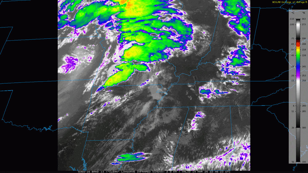
-
March 14-15 Severe Weather Outbreak
OHweather replied to HillsdaleMIWeather's topic in Lakes/Ohio Valley
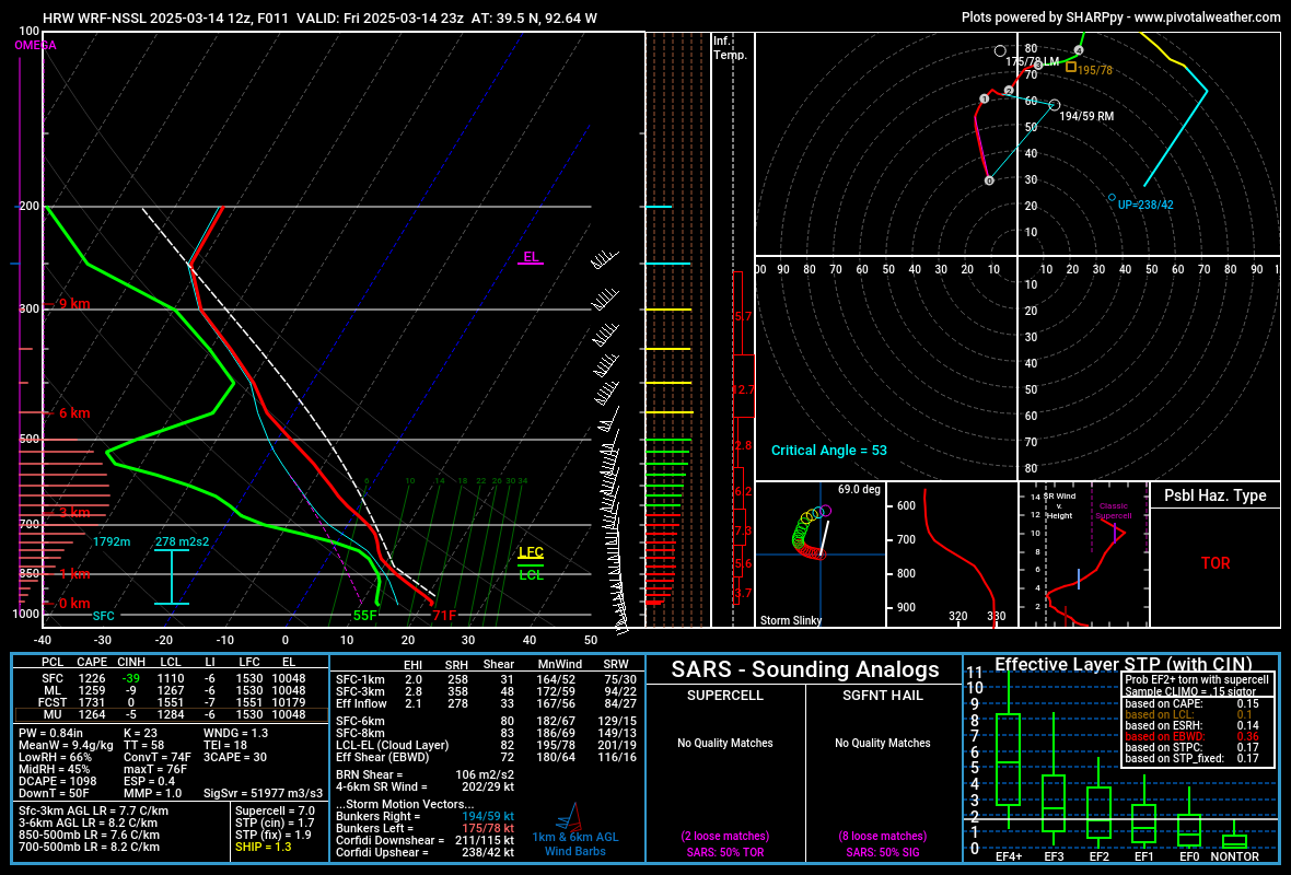
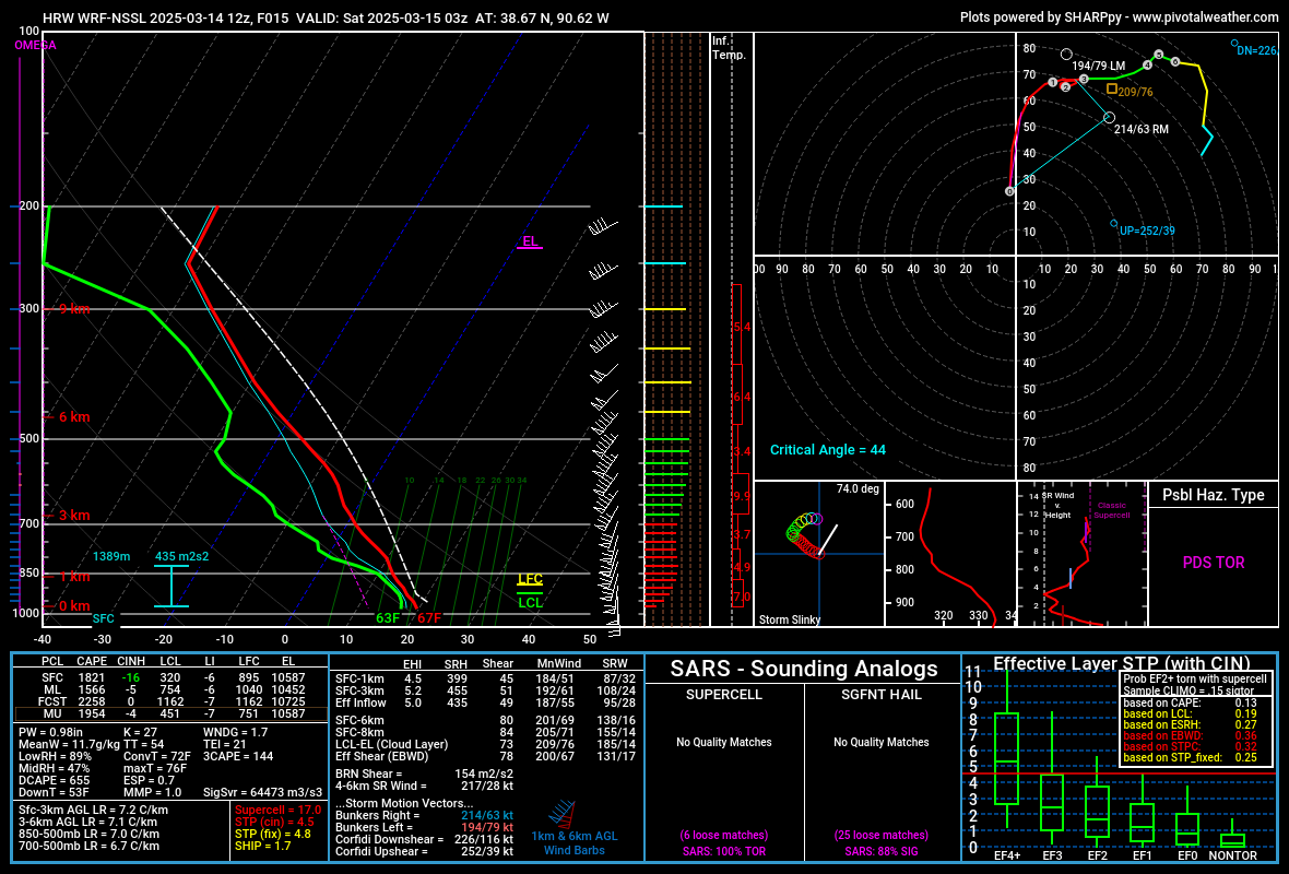
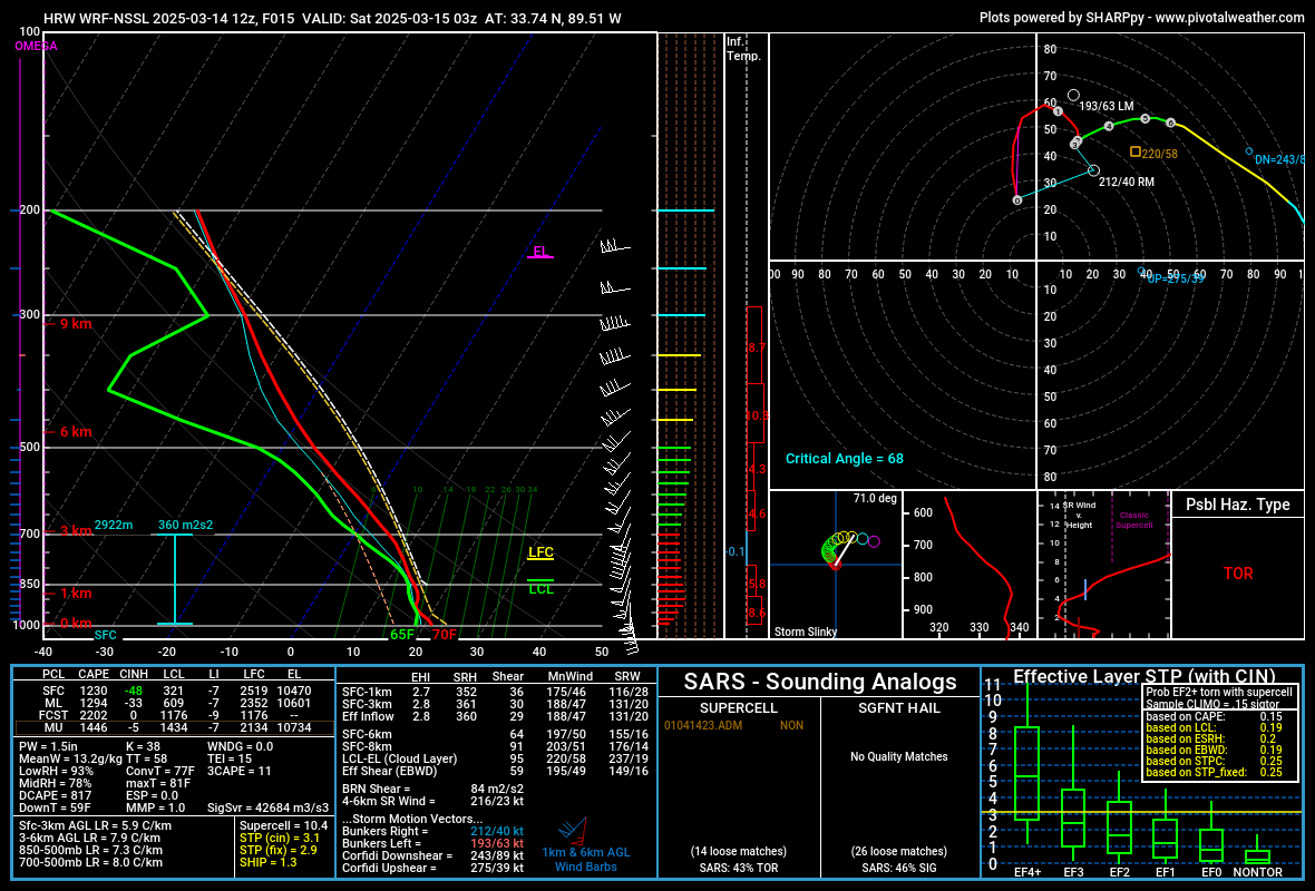
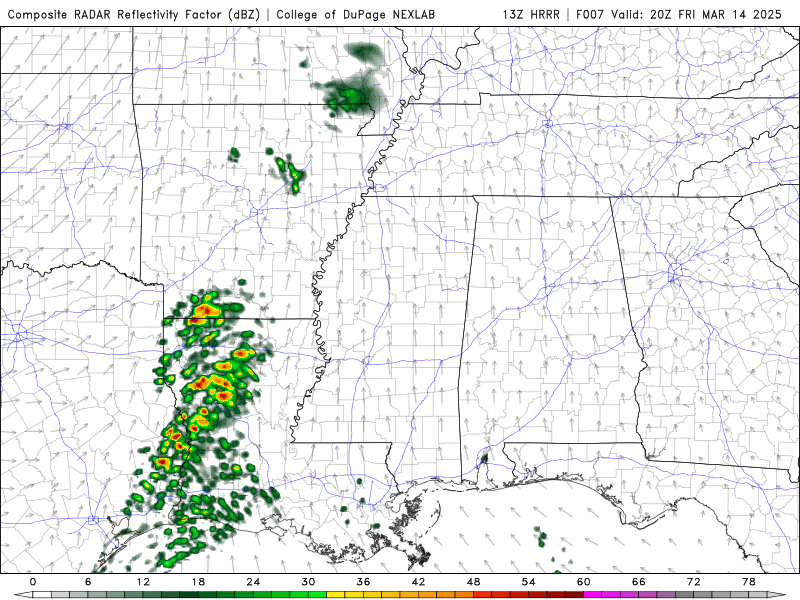
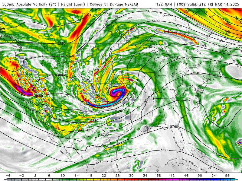
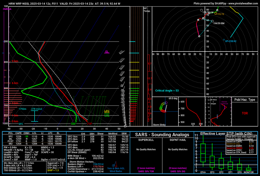
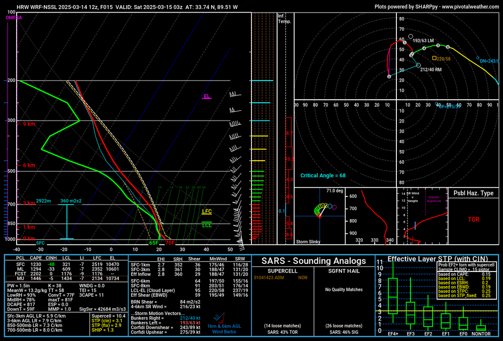
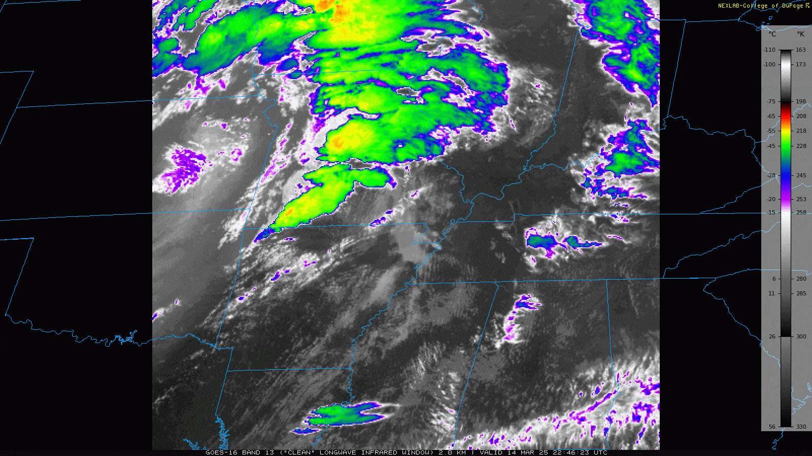
There will probably be a shit load of tornadoes from central and eastern MO into western and central IL, with the threat for stronger tornadoes probably maximized in the vicinity of St Louis later this evening. There will also be a ton of straight-line wind damage. A secondary threat for potentially stronger tornadoes is evident from MS into northern/western AL as well later this afternoon/evening. Pretty impressive model agreement on either a line, or a mixed arc of bowing segments and some embedded semi-discrete supercells evolving from MO into IA and IL this afternoon and evening, with some tendency for more cells towards the southern end of that. Some models keep this activity semi-discrete (or at least maintain decent line breaks) through much of the evening, especially into central/southern IL. This activity will be extremely strongly forced. Most CAMS other than the 3km NAM have a cluster of more weakly-forced convection developing from eastern AR/LA into MS and western/northern AL. Evolutions vary a bit more with that activity, likely due to weaker forcing. There likely will be a relative minimum in severe/tornado potential centered on western TN between these two areas, though some models have more isolated activity trying to play out even there. 3km NAM: HRRR: ARW: NSSL: They look slightly different but all agree on the overall evolution in both regimes fairly well (sans the NAM in Dixie today). No model is handling the current elevated convection great, though after 20z I kind of like the HRRR's and NSSL's reflectivity and overall evolution just a bit more than some others. You can get the idea that the northern activity in MO/IA/IL is much more strongly forced than the Dixie activity today: Something to keep in mind, the 500-700mb jet doesn't really punch into the warm sector in the upper Mississippi Valley until after 0z...so, shear profiles will already be impressive this afternoon and will improve markedly after 0z...500mb: 700mb (which is roughly 3km, so think of your 0-3km bulk shear vector for bowing segments and mesovort tornado potential, along with your 0-3km SRH). Low-level shear will be strong in the warm sector this afternoon and explode starting right around 0z this evening: Activity in the Deep South will be driven largely by a rich low-level jet, though even some of that lifts into the upper Mississippi Valley after 0z: The strong forcing argues for quick upscale growth in MO, IA, and IL this afternoon and evening, and most of the CAMs above do have a more linear mode than cellular. However, most do have hints of a more semi-discrete mode from east-central MO across central/southern IL and perhaps into far west-central IN. It is in this area where for several hours after 0z the bulk shear vectors are oriented 30-45 degrees across the expected convective line, which does argue for right-moving cells. The forcing is also a bit weaker farther south, which could assist in maintaining a somewhat more discrete mode: Some maybe representative soundings...from North Central MO late this afternoon: The shear is quite strong and the thermodynamics are sufficient for severe weather and not prohibitive for tornadoes...however, the thermodynamics could be better and the low-level flow is fairly unidirectional. East-central MO later this evening: While the low-levels aren't extremely unstable they're unstable enough, with 1500 J/KG of MLCAPE being fully sufficient for significant severe weather and tornadoes. The low-level flow could still be more backed (and may locally back more than this), though even without it the increased low-level shear after 0z increases effective SRH notably. Any bowing segments in this environment would be capable of swaths of sig wind damage and tornadoes as well...however, the main concern is if semi-discrete cells interact with this environment as some signs point to. Strong tornado potential is evident, though there are subtle limitations which may keep the ceiling for this event from blowing into the stratosphere. Here's a look at a sounding in central Mississippi this evening: Upon clicking around several of these soundings to find representative ones, I found the low-level shear to be best in the Deep South. However, the low-level lapse rates are quite weak with richly moist low-levels. That could be a limiting factor for greater tornado potential...however, the fact that most CAMs have discrete or semi-discrete cells playing out in this environment suggests tornado (potentially strong) potential, even if there are limitations. Overall, I would suggest patience. Storms will probably be severe with scattered to numerous straight-line wind reports, scattered hail, and a few tornadoes this afternoon in MO/southern IA...the northern threat likely maximizes starting around 0z, with potential for somewhat more discrete activity on the southern edge of that from east-central MO into central/southern IL. The environment this evening will support widespread/significant wind damage with any bows, along with QLCS tornadoes, with any supercells capable of all hazards including strong tornadoes. The tornado threat will gradually decrease with northern/eastern extent into IA, northern IL, southwest MI and across IN, though given the strong low-level shear QLCS tornadoes can't be ruled out where any surface-based CAPE persists overnight, assuming some organized convection can persist. There may be a relative min in severe coverage in the vicinity of western TN, with a secondary threat area focused on MS and western/northern AL. This southern threat area has tornado (potentially strong) potential, but with some overall limitations. I think east-central MO into central/southern IL has the greatest severe wx and intense tornado potential overall today and tonight, though there is a much broader area with severe/some tornado potential across MO/IA/IL/southern WI/southwest MI/IN. I could see the coverage of tornadoes and EF-2+ verifying a small 30% hatched area in practically perfect verification in the MO/IL vicinity, though some questions about storm mode, the low-level thermodynamics, and about how backed the low-level flow will be probably puts a lid on how many tornadoes stronger than EF-2/3 we can see out of this setup, which probably argues against them pulling that trigger. 10% hatched into the Deep South seems warranted given obvious strong tornado potential given the low-level shear and expected storm mode but questions about the low-level thermodynamics..gif.9e0adb249e3138f87a27876fab481a92.gif)
.gif.dbbaa30bacc98bd138d635065ecfe30c.gif)
.thumb.gif.4221e1f980b1372526a1c9e21dfe23d3.gif)
.thumb.gif.ac6f9d3afabde141a19e48132fdd0171.gif)
.gif.d32a847d0c8616a3cf600b6e10a2472a.gif)
.gif.a0fa175fa6cf321f9fa9146d73b1613f.gif)
.thumb.png.9a33d320804c48deabbf445a98fc3e70.png)
.png.c23c9db95b3fcb355da88c48319bc7fa.png)

- 248 replies
-
- 16
-

-

-

-
The light, fluffy, gradually accumulating lake effect will not quit. Another 1.8" yesterday and last night, bringing me up to a 36 hour total of 4.3". Probably will get another inch through this afternoon the way the radar looks. The office had to upgrade inland Erie PA to a LES Warning last evening, and it looks like several spotters have 6-11" of snow since early Thursday. So much for the frozen lake!

-
I did better than I thought I would into this morning, already 2.5" of very fluffy snow here. See a report of 3.5" near Garfield Heights. Looks like some localized lake enhancement.
-
Sort of an interesting snow event Thursday into Friday with a slow-moving low-level trough axis bringing light synoptic snow showers, with lake enhancement south-southeast of the flake. Should be a general light accumulation, with several fluffy inches in the higher terrain of the snowbelt.
-
Got a little under 3” with the synoptic snow through early afternoon and about 2” more with the lake enhanced snow this evening. Probably will get a bit more overnight and it’s blowing around a fair bit right now. Not a bad little event.
-
About 1.5" of snow with part 1 this morning...nothing crazy but it snowed decently for a couple of hours. As for part 2, not a huge storm, but most of northern OH looks to get a quick few inches of snow after the changeover this morning, with blowing snow and some lake enhancement lingering through much of tonight on a WNW wind into the primary snowbelt, Cleveland metro, and northern secondary snowbelt. The higher terrain of the snowbelt could see over half a foot of wind-blown snow by daybreak Monday.
-
Interesting pattern. Maybe some snow squalls Thursday evening on the leading edge of the stronger cold air advection. Models have ticked NW for the weekend storm, but it still looks like an interesting system. Should be some front end snow late Friday night into Saturday, a period of rain Saturday afternoon into Saturday night, changing to at least light synoptic snow late Saturday night and Sunday as the low pulls away. The lake is mainly frozen but there should be some enhancement Sunday through Monday with north winds gradually shifting more westerly. It will be windy Sunday into Monday so any snow accumulations will blow around on the backside of the storm.
-
What's fun is that the FAA's full time meteorologists are technically NWS employees, and the NWS has a whole national center (the Aviation Weather Center) dedicated to aviation weather because of how obviously important and impactful it is to public safety and the economy. It's not the FAA personnel at the 21 air traffic control centers who want to get rid of the meteorologists based there, it's higher ups at the FAA, and they were closer than they should have been to getting their wish recently.
-
So, as an NWS met who routinely sends out climate reports for first order sites, including snowfall, this exchange was fascinating to me. We have 6 first order climate sites in our CWA that all measure snow. 3 are FAA contract observers, with the observers measuring the snow for the site. The other 3 are snow paid observers. The snow paid observers are trained to report trace depth and do so. The 3 sites with FAA observers do not officially put the Trace in their obs, however, they do note it in their logs. We call them every 6 hours to verbally get the new snow and depth and they tell us the traces. So needless to say, while I knew the T depth did not show up in the METAR and doesn't get pulled into our system, I had no idea that it's technically not a valid ob based on FAA standards that sometimes isn't reported.
-
Nice overperforming, fluffy lake effect event. I'm nearing 6"!
-
Looking back at mesoanalysis, there are some hints that there was a thermal gradient and some weak convergence at 700mb (which was right in the DGZ), so maybe that was enough, but it was a small feature and not modeled well. There was also some banded snow that got into the Canton and Youngstown areas that produced a few 4-5" reports. Otherwise, pretty meh. 1.4" here. I had the forecast during the day yesterday and the 12z guidance generally trended down somewhat with the QPF from prior runs, which was ultimately the correct trend. The radar had somewhat of a banded appearance upstream with a lot of sites dropping to 3/4 mile or less visibility so I was apprehensive to lower our snow much (especially since we already had an advisory out for most of the CWA), and we did have those two small areas of banded snow that produced a few inches, but otherwise this was a very boring synoptic snow that came in on the low end of expectations...though it was widespread at least and freshened up the pack a bit.
-
Got another 3" of fluffy snow yesterday into last night, though it seems to finally be done for now until we get our quick hitting synoptic snow later Friday. I'm at over 20" of snow for the month of January so far (about 22" by my quick math). Satellite confirms that ice in the western basin...pretty much completely frozen west of the Islands, with a decent area of ice along the southern shore east of the islands. Most of the central and the entire eastern basins are open, but ice will continue gradually expanding for the foreseeable future.
-
It's been a snowy week...almost 3" here last night into this morning. Ice will be an issue going forward, though shouldn't be too prohibitive to LES yet next week. However, with no warm ups in site (what a thing to say in winter around here) the ice will continue growing the next few weeks. There should be some decent LES next week, though the flow direction is unclear as it may be more westerly. I will be out of town Monday-Friday next week so we'll probably get crushed.
-
Topped out at 11.8” storm total here. Thought we had a good chance to crack 12” here, but never got back under any great banding for a period of time yesterday afternoon or evening.

.gif.98f45cd2f48c6e52e8b2049cb36f63b8.gif)
.gif.ea7d1ef20d1b487ae73ec81ea41ccee3.gif)
.png.8bc35c51190109c1fc55d2a397fa931d.png)