

Bubbler86
-
Posts
29,675 -
Joined
-
Last visited
Content Type
Profiles
Blogs
Forums
American Weather
Media Demo
Store
Gallery
Everything posted by Bubbler86
-
Very Rgemy
-
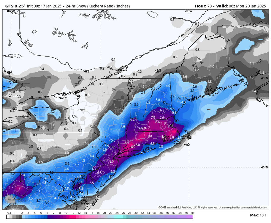
6Z had the SE Snow on the higher res as well. It pretty much held serve IMO with a slight NW adjustment.
-
Like I said I would not call it alone, it is not far off from the other less amped models. As the Pitt poster pointed out, better resolution on 3K picking up qpf better.
-
It is not THAT much different than the Icon and Euro. Similar progression of a low off shore. Just less qpf.
-
-
It may be slightly better but not going to be what we want yet seeing panel 54.
-
Nam should be better IMO after seeing the panels up to 42.
-
That was their AFD, did not check zones. Checking now, mine and MDT says 2-4 fwiw. I think the zones are automated/AI though. The Map MJS posted is the ground truth which was low and par for the course with them.
-
I wish we could see low positions or at least snow maps to eliminate mixing/rain but for all snow, that is probably more than the rgem right now. Nam rolling.
-
Yea, plus going with the high one and no scientific reason why is fraught for a bust :-). I read the wrong GFS this AM which made my first post sound less optimistic. I read on the MA forum that almost half the EPS members have us getting nothing which is a lot for 48 hours out so not laughing off the NAM either. I won't use mean snow maps seriously but will take a bunch of members as a sign to wait before pulling too many triggers! The Gefs and Geps were a bit more smoothed I believe.
-
The official report I see does say .2 with no snow since midnight last night/today.
-
NWS going below me. No surprise there Confidence is increasing in a period of accumulating snow across the south and east Sunday as a wave of low pressure develops along the thermal boundary along the North Carolina coastline. Given how broad the trough is, there is above normal uncertainty in the exact placement of the axis of heaviest snow, but as of right now model consensus is for 2-4 inches of snow accumulation across the southern tier and the Lower Susq Valley on Sunday. It should be noted, however, that the reasonable worst case scenario would be a sfc low developing faster and tracking closer to the Mid Atlantic coast, which could but us in a position where the Lower Susq sees warning criteria totals (5+ inches). For now, the chc of warning criteria snow totals remains just below 30%, and it is more likely that we would end up hoisting a Winter Weather Advisory in the coming days.
-
I usually get just to the left of the elevated total area. In fairness it was higher than I quoted when I said 2-3 as it was closer to the 4" line.
-
www.pivotalweather.com
-
Right, and I am close to that 4" line. I also think Kuch may be a tad high on the UK depict but not getting into that convo. The point was it was not the 6-10" of the models in the "higher camp". If forecasting just off the GFS, AI and Canadian the totals would need to be 6-10 I think.
-
6Z looked 3 to maybe 4" to me. I am to the left of the pink area.
-
I would be worried about big rgem level snows if we still have the majority of models showing it passing off or transferring off the SE Coast tomorrow AM. If I had to forecast for the LSV right now I would go with 3-6".
-
A lot of models show me getting 2-3", was just trying to catch up as in what is usually case, the models not showing snow are not posted as much. UK, Euro, Nam, Icon are all much lower than the others I quoted.
-
I edited it as I was looking at the 0Z.
-
Quick scan, we have the Chatgpt, Canadian, GFS showing 4"+ (editing to add GFS) and everything else is less?
-
I like this better than the rgem but is complicated.
-
Still 3-5 for lsv before the transfer.
-
@DDweatherman called it. Jersey Shore mauler. We are miller'ed.
-
Primary transfer between 63 and 66.
-
Riding up the front but not overly amped.


