

frd
-
Posts
6,130 -
Joined
-
Last visited
Content Type
Profiles
Blogs
Forums
American Weather
Media Demo
Store
Gallery
Everything posted by frd
-
Yikes, what a a drop. Also, combine that - EPO with a favorable elongated PV, and it ups the odds of a cold powder storm later in the month.
-
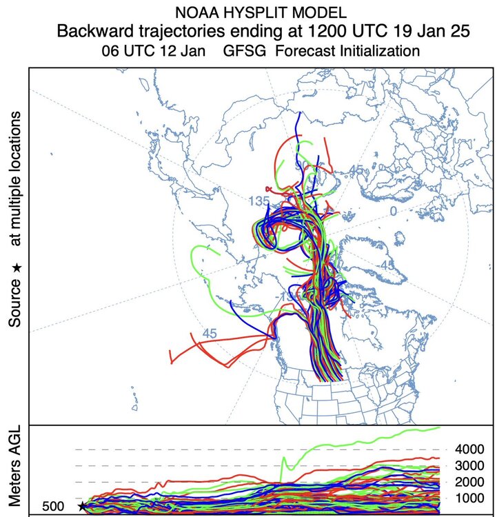
Arriving from Siberia to your house soon. https://x.com/webberweather/status/1878439902720753747 Eric Webb @webberweather <The brutally cold arctic air mass that enters the CONUS a week from now originates over Siberia about 10 days earlier & starts out at -30C to -40C.>

-
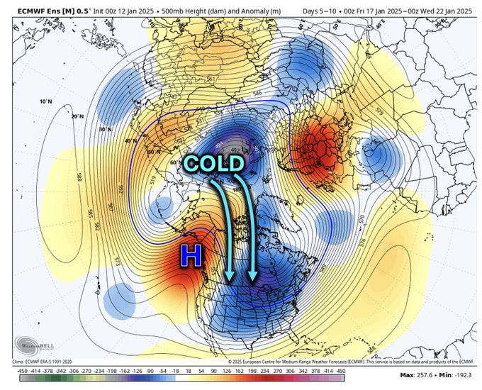
If you look at the blocking regimes and observe the NAO there is significant potential for a classic Mid Atlantic SECS event, during the favored window of Jan 18 th to Jan 25 th . Current forecast do not show any deep dives in the AO or NAO indices. NAO getting ready to reverse near Jan . 20 th The driver is the EPO. As Tomer states the increased risks of SECS can extend days past the end time of the Greenland High regime. https://x.com/burgwx/status/1878092022277636324
.thumb.jpeg.38e0d6ce78a97d601b80999038b25afc.jpeg)
-
.50 inch here Very pretty. What a great week winter wise.
-
Appears most of the action including cold /snow is up North and NW. Dismal snow map regardless of whether it is useful or not. Maybe its just the GFS.

-
In this area we still appear to have a decent delivery method for cold. I am not worried about rain at this time for the potential system near the 20 th. Meanwhile, nationwide snow cover continues to expand, more so with the southern system next several days.
-
https://x.com/burgwx/status/1877356736488652849 Tomer likes late Jan for Mid Atlantic snowstorm potential

-
Any time for long range tidbits ?
-
Wow, more than double from Middletown, DE. Be careful driving. Wind chills this morning are rather nasty. A true deep winter morning. Temp here curretnly at 20 F.
-
What was your snowfall total ? Here I measured 4 inches. We do have snow blowing across corn fields
-
Next 7 days look dry, but cold. Thought we had a chance with this one, but looking slim at the moment.
-
clickbait
-
Yes, the lows are trending West and clustering, similiar to the GEFS earlier, just not as robust. Interesting and hopeful to say the least.
-
Upper energy rolling through soon. Banding developing to my West and NW. Maybe get an additional inch.
-
How can you interpret whether the GEFS it not simply following the leader ?
-
Remind what you said a few days ago about the accuracy of the GFS versus the ECM in Canada with the Northern jet in various regimes, PNA/EPO?
-
My location as well, forecast was 6 to 8. Total here was 3.5 inches. Saturday has potential, might even trend colder. Mount Holly states - It will still take several model runs to get a handle on this system. For now, will follow NBM PoPs and carry slight chance-chance PoPs over the area Friday night through Saturday, and even though forecast high temperatures are above freezing on Saturday, based on wet-bulb temperatures, the dominant p-type would be snow. High pressure returns on Sunday and Monday.
-
Without question. Many clustered West versus earlier far offshore.
-
I believe so, but could be machine generated. They came directly from the new update from Mount Holly. If you check out Richmond, VA they still have the mention of snow.
-
Well, it was in the actual forecast as a chance of snow yesterday, however, today it is gone. Zone 19709 Friday Sunny, with a high near 34. Friday Night Mostly cloudy, with a low around 22. Saturday Partly sunny, with a high near 35. Saturday Night Partly cloudy, with a low around 22. Sunday Mostly sunny, with a high near 36.
-
Mount Holly removed the wording of snow chances for this Saturday. However, they did discuss the potential. potentially active pattern will resume beginning Friday night and especially on Saturday as another upper-trough and associated surface low pressure system works its way toward the area. As expected at this forecast range, there are major discrepancies between each deterministic model, and from run to run. For now, went with mostly NBM probabilities for precipitation, though tempered them a little, and have chance PoPs for snowfall Saturday into Saturday night. From the overnight models, the GFS seems to have the most impactful solution for our region while the CMC much less so and a complete miss on the EC. Stay tuned for changes as the week progresses.
-
https://x.com/jhomenuk/status/1876047049285836995 There has been a lot of discussion about the phasing here. In actuality, there are multiple phases occurring - a first phase with a Pacific disturbance around 84-96 hours, and then a second (And potentially third) phase with a more "true" polar disturbance. Extremely complex.
-
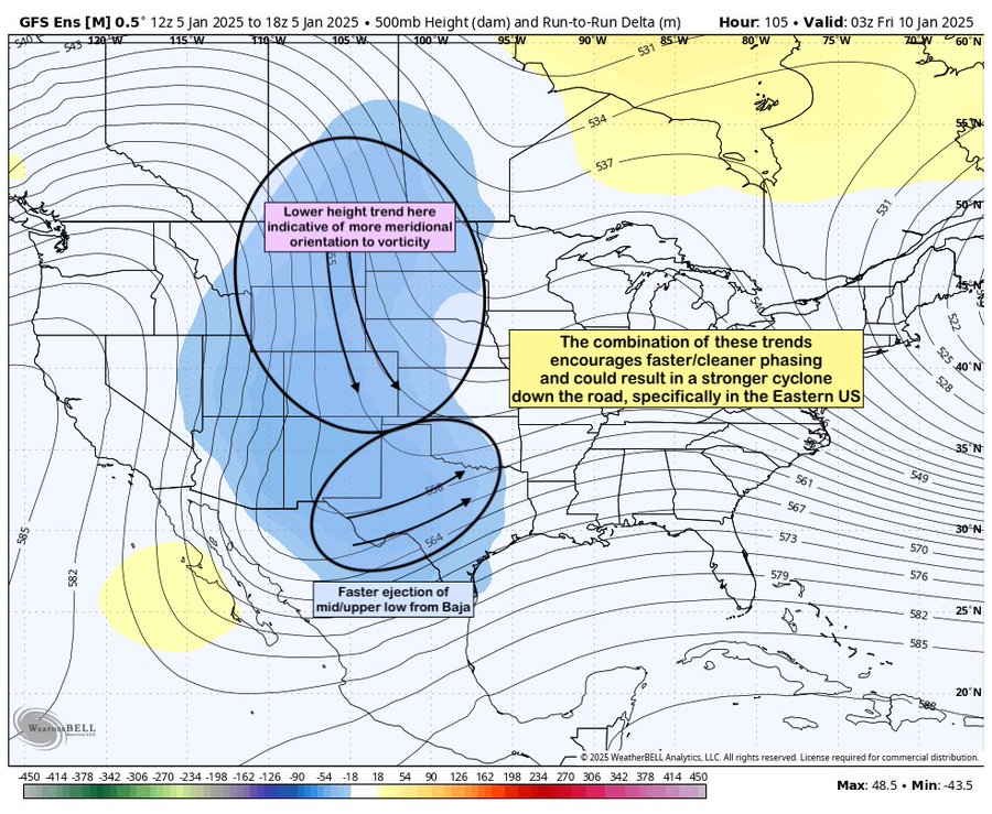
https://x.com/jhomenuk/status/1876047026221424731 John Homenuk @jhomenuk This evenings GEFS has trended sharply towards a more meridional orientation to vorticity entering the US & a faster ejecting upper low from the Baja Days 4-6. Should this trend continue, chances for a strong Eastern US cyclone next weekend could increase. A very volatile setup.
-
Give it a couple days
-
18z Euro goes to 144 , maybe will show new trend or GFS like solution.

.jpeg.39bc5449da2e9821a54d60f0b64d2468.jpeg)
