

frd
-
Posts
6,132 -
Joined
-
Last visited
Content Type
Profiles
Blogs
Forums
American Weather
Media Demo
Store
Gallery
Everything posted by frd
-
Bob Chill got over 30 inches, and my area was on the Eastern end of less forcing, I measured 13 inches, areas to the West much higher. NWS forecast was for nearly 22 here.
-
Ah, that explains it. Hey, I agree things look very good, I am awaiting on a general MECS, its been many, many years, even 2016 was a dissapointment here.
-
My takeaway is simply whether its cold enough with a robust moisture plume moving up and over our region. Playing the Devil's advocate is all I am saying.
-
GEM not impressive with 10 day snow totals. HL blocking configuration is weird looking compared to other models. Meanwhile it appears the PV split and SSWE forecasts have calmed a bit, ( yes its really not needed ) reading about the continued battle between the SER and the -AO. Question is, will it be cold enough down here in DC., Baltimore and the lowlands for all snow events. We have the mositure, but do we really have the cold ? And, will the cold hold ?
-
In the snow department it appears areas up to our North cash in the best. Maybe all snow versus uncertain amount further South. Still not seeing the low lands cashing in yet in a big way.
-
I have to do a fact check, not sure. That might be the other guy who is a bigger hypster than JB, he names starts with a M.
-
He is a met, but posted it because he thought things would be West in that time frame , as in ( slide to our West ) and then you posted AI goes offshore. Great potential next 30 days I believe, but its going to take a little more time to target our first legit threat. Observing the HL and the PV is fascinating though, and how it all plays a role with the upcoming favorable indices.
-
Opposite of what he thought. I have read several mets think the flow is too progressive and systems slid by too quickly or offshore. https://x.com/MikeTFox5/status/1886219484463055260 Biggest issue to me with that 11-14th time window is that your long wave trough is positive and wayyyy back to the west. You got room for systems to slide west. I think you need to wait for it to shift east. So I’m more of the 15-18th time period vs 11-14th which I think is a little fast. Just my opinion here.
-
That will not do. For me
-
Wonder is anafront sets up the next event .
-
The coldest and snowiest part of the pattern is likely after this, extending into March
-
BAMM upcoming analogs based on the forecasted pattern The upcoming pattern lines up rather nicely with years like 93,14 and 2021. The BIG wildcard could be the -NAO that might rival years like 2010 etc. There really isn't a great match overall for the upcoming -EPO/-PNA/-NAO/-AO mid Feb pattern. These look good for now. Where did it snow in these years? Some heavy hitters in there. The all model NAO forecast is remarkable. There will without a doubt be some big eastern US snow risks.


-
Hopefully not.
-
Every new day, a more negative AO forecast, also a dropping NAO, and surprise the PNA has improved as well.
.thumb.png.05cc2356a7acf4f1177d43d1f660c2a2.png)
-
Wonder if surpression depression returns and eliminates our chances of meaningful snow, because of either too much blocking or a too far displaced TPV in SE Canada or even further East. I have heard the cases for more NW track this go around in Feb, and early March, more latent heat, shorter wavelenghts, etc.
-
Well, you might have stayed in a Holiday Inn Express.
-
Doesn't the Euro tend to over amplify ?
-
Seems improved pattern favoring a SECS pattern is moving up quicker in time, versus late month or a can kick.
-
Its coming The AO is going negative, atmospheric river for the month of Feb and early March. TPV in Se Canada and the cherry on top - a PV split with immediate impacts per Bamm. https://x.com/bamwxcom/status/1885678378562310475 Buckle up friends. A total SPLIT of the stratospheric #Polarvortex is showing up in all the data. Splits from the top down deliver impacts quick. Winter is coming back with a vengeance late month into March. The troposphere is driving the heat flux into the stratosphere leading to the split so we’d get cold from the initial tropospheric forcing anyway. What then happens with the split is blocking sets up and allows it to linger as seen below with all model NAO/AO.
-
AO set to go negative by mid Feb.
.thumb.png.c0b217d90f148d4b21cf3abc497e279e.png)
-
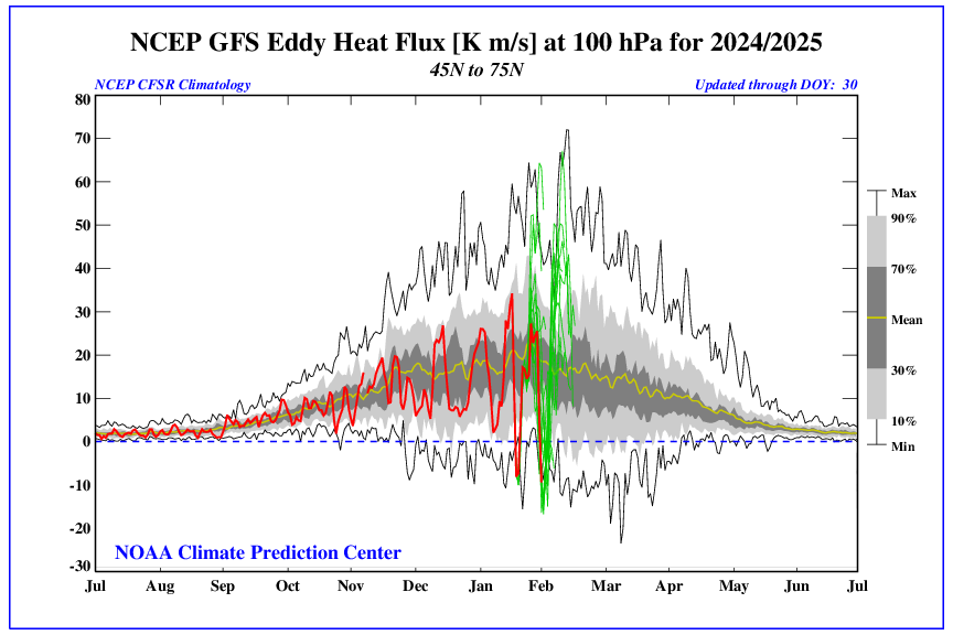
https://x.com/burgwx/status/1885138563982917803 From Tomer Regardless of whether a sudden stratospheric warming (SSW) event occurs or not, the stubbornly strong stratospheric polar vortex is likely to weaken — both GFS & ECMWF show anomalously strong 100-hPa poleward heat flux: The TPV tends to remain in SE Canada per Bamm https://x.com/bamwxcom/status/1884994744310178230 We have a continued source region of cold air moving into the middle of Feb and beyond. - NAO looks to develop as mentioned, along with a gradual - NAM state.

-
This is supported by lastest AO forecast. Also, there is a strong heat flux set to take place next week. Expecting to see a - NAM state by mid Feb.
-
Going to take a while for maritime forcing to become more favorable for the East. Meanwhile, still awaiting for continued signs regarding a drop in the AO. If and when the cold air takes over in the East, it may coincide with a very active weather pattern. Some late Feb and early March analogs are very active precip-wise.
-
January Medium/Long Range: Chasing more snow to close out the month
frd replied to mappy's topic in Mid Atlantic
I imagine that configuration helps guide colder air towards our area, and may have a role with the PV being on our side of the NH. I have not heard of any SSW events, but we do not need them the way the Pac has been cooperating. -
January Medium/Long Range: Chasing more snow to close out the month
frd replied to mappy's topic in Mid Atlantic
Not really surprising to see that blocking over the top. If you look at the previous rise in the AO during mid Fall, you will see several cycles down ( each one a little more negative ) which happened over a period of about 6 weeks. The peak - AO occurred about 10 weeks after the mid October + peak AO, however, not sure if we repeat that amount of time this go around. I believe we will see a continuation of the AO gradually trending negative again with the - AO peak sometime in March. This should favor another snowfall threat for the Mid Atlantic.


.png.5fec8758417c3508c2d3a480530495d1.png)

.png.6e442355885e882b40fff856e2ab2bdf.png)