

frd
-
Posts
6,126 -
Joined
-
Last visited
Content Type
Profiles
Blogs
Forums
American Weather
Media Demo
Store
Gallery
Everything posted by frd
-
Would not be surprised to have the GFS trend North next 24 to 48 hours.
-
I am going to be nutless after this winter.
-
Your description seems that both threats are not Miller A. And both threats are not widespread. Besides warning level snows here, what is missing are widespread snowfalls that strike points from DC North to Boston. Or, at the least, say lower VA. to say Trenton, NJ.
-
SE "Tropical "Ridge on roids. More expansive then the block.
-
If it does hold then its time for that conversation that @psuhoffman mentioned. On to the EPS
-
I have seen that too in previous years. A negative NAO block linking with the SER/WAR . Hope that is wrong. Ugly . Crazy GFS from just 6 hours ago.
-
The negative AO trends continue today with the latest updates, now pushing near -4.25 SD. , the PNA has trended more positive within the backdrop of a -NAO during this time. PNA looks great
.thumb.png.53baafe6ed25993f9d825aa19657db36.png)
-
I prefer it where it is . And, don't be surprised at a severe Nor'easter type event near this date, because the GFS has seen these at long range the past 25 years. Dare I say March 2001, DT's Pamela Anderson bust storm. Was oh so close. It took me a year to recover mentally.
-
I been frustrated, but I am holding psu to the bigger dog in our neck of the woods eventually . Good luck Rev, maybe we score over the next 30 days with a warning level snowfall.
-
Another way to fail. All good, I am use to a buffet of failure this winter here. Oh, you are not a horrible person.
-
Generalized thoughts, lack of cold yielding more wet versus white.
-
95 % of this will be rain here. We just don't have any really cold air to work with, and lock in place. Very strange. Disclaimer, a miracle could happen, I love to be wrong.
.gif.48329a1f33eec5ce5b59c9010a3daeed.gif)
-
Jesus Christ what the hell do we have to do to lower heights in the East and SE. Freakin nuts ! Do we have to locate the PV over Chicago?
-
Always seems the least likely failure option(s) becomes reality here most times.
-
Blocking and favoring our area might still be in the cards, I give it some more time.
-
The AO looks to go to - 4 SD . That would raise the bar mid month and beyond for a higher level threat. Another improvement today with the AO forecast.
-
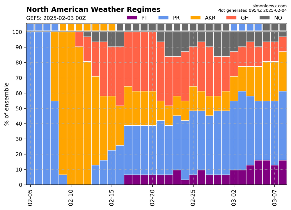
Next week we are in a hybrid pattern of regimes favoring frequent snowstorms of lesser intensity . A combo of the Greenland high regime and the Alaskan Ridge regimes. https://x.com/burgwx/status/1887293421917700567 From Tomer, Note I said frequent snowstorms - I didn't necessarily say *major* snowstorms. The *biggest* snowstorms historically are more likely to happen during Greenland High regimes, while Alaskan Ridge regimes can favor more frequent snowstorms, but with a lower individual ceiling.
-
That is correct Yes, in the very old days before Eastern there was a BB about weather called Wright weather
-
@psuhoffman my local area tends to do better in several scenarios. Intense and deep CAD where erosion of the airmass in minimal. Temps starts out in the lower 20's or teens before the snow arrives. Moderate events where by the time the dry slot arrives most of the snow has fallen already. Nino seasons with cold high pressure to my North or NW , active STJ, over-riding storms with a very cold pre airmass gives this area high end snow totals, thinking 2003, 2009, 2010, to a degree 2016 Nina seasons with moderate to severe AO. 1996 My area tends to do well with a moderate -AO , and a moderate -NAO +PNA backdrop, for huge snows the NAO and AO need to be pretty negative. I do not participate in snows that hit Rehoboth, De because I am too far inland. I can benefit from severe Nor'easter Snowstorms if the low pressure area offshore stalls or does a loop. Thinking the late 1970's. I can do well with clippers if the clipper is robust. Overall I can score if temps cooperate in I-95 storms. I appreciate your posts and look forward to at least one lowlands SECS in the next 30 days.
-
Middletown DE. 19709
-
Exactly. Some folks, even myself, take models at long leads too seriously.
-
Do you think the blocking migrates further South as we near the end of the month in a position more favorable and impactful to our area. Really talking the NAO block. Thoughts
-
Some good news is much appreciated !
-
Is that the two day warm up ?
-
Heights should get lower in time. All I know is we suck here with snow in Delaware. However, I will keep the faith and go with @brooklynwx99 ! for late month. The best is yet to arrive.


.png.116fbb620fce79010f0f0d9a45da7d1e.png)


