

frd
-
Posts
6,141 -
Joined
-
Last visited
Content Type
Profiles
Blogs
Forums
American Weather
Media Demo
Store
Gallery
Everything posted by frd
-
Will be interesting to see if the roll forward analogs do indeed result in a more conducive pattern for cold and snow in the East by early to mid Jan 2022. Certainly appears the cold and snow hits out West first.
.thumb.jpg.720925c95e8f0086be9d6bdaad83f18f.jpg)
-
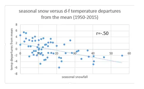
I liked this scatter diagram the best. Snow lovers may want to know: Does a cold winter support a snowy winter? Your grandmother would’ve said so and that common sense answer is the right one. Cold temperatures correlate with a snowy winter better than any of the indices I just discussed. Below is a scatter diagram of winter temperature anomalies and seasonal snowfall.
-
Both the EPS and the GEFS support a - 5 PNA. Also, the PNA remains negative for the next 360 hours.
-
Some of the seasonal models keep the negative PNA pattern for the duration of the winter. We certainly will need some luck to score at this lower latitude. Cannot overemphasize the importance of some cooperation from the Pac.
-
December 2021 Medium/Long Range Discussion Thread
frd replied to North Balti Zen's topic in Mid Atlantic
Early to mid Jan cold odds increasing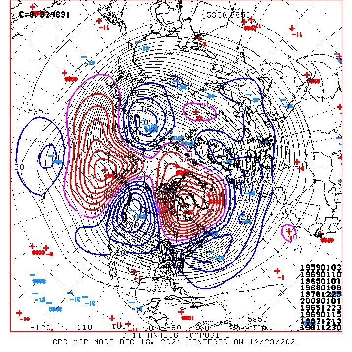
-
December 2021 Medium/Long Range Discussion Thread
frd replied to North Balti Zen's topic in Mid Atlantic
Really need some Pac help. At this point a - NAO will not cut it for the low lands. -
December 2021 Medium/Long Range Discussion Thread
frd replied to North Balti Zen's topic in Mid Atlantic
.thumb.gif.eb8773f0119156b93b3c0e6ac110ae9e.gif)
-
December 2021 Medium/Long Range Discussion Thread
frd replied to North Balti Zen's topic in Mid Atlantic
- NAO retrograde looks better today, but the Pac is still so so. I feel we are never really going to see anything but a minor window of improvement on the Pac side during the course of the winter. Although there may be a favorable Pac transition in early Jan according to Roundy. -
December 2021 Medium/Long Range Discussion Thread
frd replied to North Balti Zen's topic in Mid Atlantic
This is unusual. It did happen in Jan 1980. -
December 2021 Medium/Long Range Discussion Thread
frd replied to North Balti Zen's topic in Mid Atlantic
Cool animation. Like Webb states, far from perfect, but shows one possible progression moving forward. -
December 2021 Medium/Long Range Discussion Thread
frd replied to North Balti Zen's topic in Mid Atlantic
Will need to watch this constructed analog progression in the weeks ahead centered on 1-13-22. -
December 2021 Medium/Long Range Discussion Thread
frd replied to North Balti Zen's topic in Mid Atlantic
Fits @brooklynwx99 's roll-forward West based - NAO research. Pretty cool ! -
December 2021 Medium/Long Range Discussion Thread
frd replied to North Balti Zen's topic in Mid Atlantic
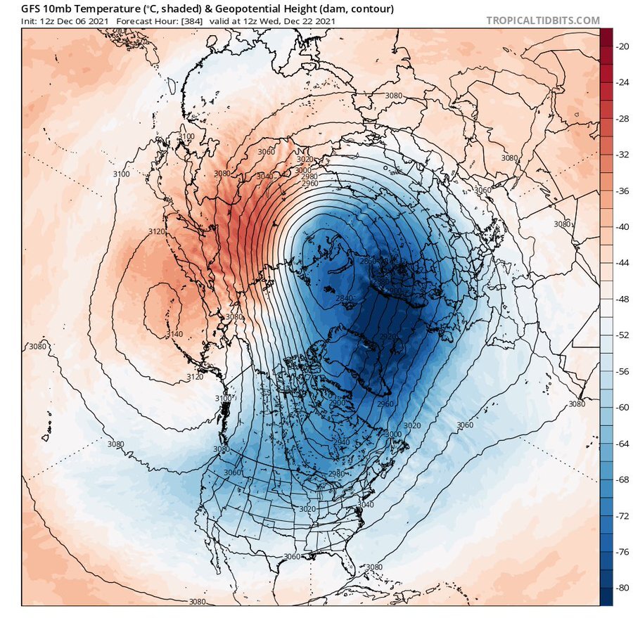
Interesting as well are the changes in the placement and orientation of the PV as we near the end of the month. -
December 2021 Medium/Long Range Discussion Thread
frd replied to North Balti Zen's topic in Mid Atlantic
From a respected met is this interesting roll forward analysis. This December appears to finish with a -NAO/-PNA combo. He stated that " Januaries that historically followed Decembers with a -NAO/-PNA featured favorable patterns for the E US with a significant west-based -NAO: -
December 2021 Medium/Long Range Discussion Thread
frd replied to North Balti Zen's topic in Mid Atlantic
@psuhoffman Goes along with what you said. From Webb.....posted today. these slower-moving West Pacific MJO waves during La Nina are actually the most likely to significantly disrupt the stratosphere and create stronger, long-lasting -NAOs because of the poleward displacement of the N Pacific jet during La Nina (focusing more wave fluxes onto the mean state/over eastern Russia when active WP MJO is present) & greater separation between the Pacific + Atlantic jet streams as well as large wavelength Rossby Waves in the N Pacific jet. -
December 2021 Medium/Long Range Discussion Thread
frd replied to North Balti Zen's topic in Mid Atlantic
Still out in time, but provides some hope for late month. -
December 2021 Medium/Long Range Discussion Thread
frd replied to North Balti Zen's topic in Mid Atlantic
Keep moving MJO -
December 2021 Medium/Long Range Discussion Thread
frd replied to North Balti Zen's topic in Mid Atlantic
It may effect the PV in a positive way. -
December 2021 Medium/Long Range Discussion Thread
frd replied to North Balti Zen's topic in Mid Atlantic
That should start to help shift things around. -
December 2021 Medium/Long Range Discussion Thread
frd replied to North Balti Zen's topic in Mid Atlantic
Maybe some positive changes start near December 20 th.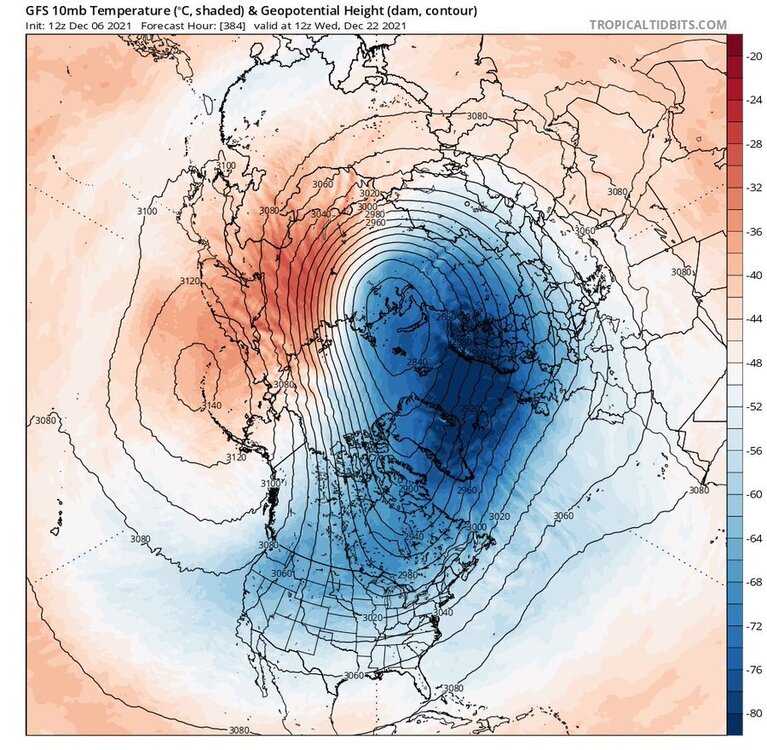
-
December 2021 Medium/Long Range Discussion Thread
frd replied to North Balti Zen's topic in Mid Atlantic
To balance things out. -
December 2021 Medium/Long Range Discussion Thread
frd replied to North Balti Zen's topic in Mid Atlantic
We all laugh at Dr Cohen @CAPE , but I will say this, last year looked better at this point. We had record NA snow cover and a cold period in December. ( even though we experienced the same typical warmth period after Dec. 15 ) I think there is something to be made of a healthy cryosphere and extensive snow cover. So far the AO forecast have been getting uglier and uglier..thumb.gif.188ab3c631573886d081747c1640ca31.gif)
-
December 2021 Medium/Long Range Discussion Thread
frd replied to North Balti Zen's topic in Mid Atlantic
Take this with a grain of salt. But, in a Nina and with the base state we have I can see this happening. -
December 2021 Medium/Long Range Discussion Thread
frd replied to North Balti Zen's topic in Mid Atlantic
It appears that the early seasonal forecast from the euro and even the UK met portraying a weakening of the vortex at the end of November and in early December is not going to pan out. The vortex remains firmly planted over the North Pole and doesn't even offer any displacement towards North America. It would appear that those calling for a front loaded winter may not get it. It would be ironic if the heart of Winter produces which is not typical of a la Nina. -
December 2021 Medium/Long Range Discussion Thread
frd replied to North Balti Zen's topic in Mid Atlantic
I have not seen the Control for the GFS or the Euro score a win in many years during the late Fall or Winter when it comes to predicting potential snowfall. Meanwhile, I would be concerned regarding a poor NAM state, and the lack of any posts from HM about the upcoming winter..thumb.gif.6dcf297bf90bd7cc07555cf8c6a25285.gif)
.jpg.62b1fad2fdd6886b7a56091aa5bdc74e.jpg)


.gif.66352be24f418be41b9b20e6ee8e2d34.gif)

.gif.26cad6f176fa8c7830606b692878d611.gif)
.gif.7801d2737948c38b02668bb4a7ed4a63.gif)