

frd
-
Posts
7,202 -
Joined
-
Last visited
Content Type
Profiles
Blogs
Forums
American Weather
Media Demo
Store
Gallery
Everything posted by frd
-
https://x.com/RyanMaue/status/1952745028704420168
-
Polar jet far to the North, with High pressure to the North of us West to East, lessens the possibility of a re-curve "if" a hurricane were to near the US SE Coast. Depends on the strength of the Bermuda High as well.
-
Yes, up North even worse.
-
Hmmm
-
Was at the beach yesterday and the water was very, very warm. Also, the surf was rough with a NE wind that changed to Southerly in the afternoon, waves were messy, hard to ride with mostly onshore flow. The good thing was no jellyfish were sighted at North Wildwood.
-
There is a haze as well going on. Smoke at higher altitude I guess, but there was some mixing down possibly responsible for what I smelled on a walk early this morning.
-
Even though the air quality alert was taken off the forecast here in Delaware I can smell forrest fire smoke.
-
Sun came out briefly a bit ago, things really sped up compared to yesterday's forecast. Temp down to 74 with a NE wind presently.
-
1.84 inches here after the second storm. What a crazy July. So much rain the lawn had fungal disease this month, versus going crispy dormant.
-
Nasty storm arriving from the West. Very dark with lightening strikes. Ominous looking.
-
Speaking of flooding in Northern Delaware here you go. Flash Flood Warning DEC003-NJC015-033-PAC045-312245- /O.NEW.KPHI.FF.W.0083.250731T1846Z-250731T2245Z/ /00000.0.ER.000000T0000Z.000000T0000Z.000000T0000Z.OO/ BULLETIN - EAS ACTIVATION REQUESTED Flash Flood Warning National Weather Service Mount Holly NJ 246 PM EDT Thu Jul 31 2025 The National Weather Service in Mount Holly has issued a * Flash Flood Warning for... Northern New Castle County in northern Delaware... Northwestern Gloucester County in southern New Jersey... Northwestern Salem County in southern New Jersey... South Central Delaware County in southeastern Pennsylvania... * Until 645 PM EDT. * At 246 PM EDT, Doppler radar indicated thunderstorms producing heavy rain across the warned area. Between 0.5 and 1 inch of rain has fallen. The expected rainfall rate is 1 to 3 inches in 1 hour. Additional rainfall amounts of 1 to 2 inches are possible in the warned area. Flash flooding is ongoing or expected to begin shortly. HAZARD...Life threatening flash flooding caused by thunderstorms. SOURCE...Radar. IMPACT...Life threatening flash flooding of creeks and streams, urban areas, highways, streets, and underpasses. * Some locations that may experience flash flooding include... Wilmington, Newark, Chester, Pennsville, Carneys Point, Elsmere, Paulsboro, New Castle, Penns Grove, Swedesboro, Delaware City and Newport. PRECAUTIONARY/PREPAREDNESS ACTIONS... Turn around...don`t drown when encountering flooded roads. Most flood deaths occur in vehicles. && LAT...LON 3968 7576 3978 7551 3980 7542 3987 7532 3976 7513 3969 7530 3957 7557 3949 7574 FLASH FLOOD...RADAR INDICATED FLASH FLOOD DAMAGE THREAT...CONSIDERABLE EXPECTED RAINFALL RATE...1-3 INCHES IN 1 HOUR
-
Pretty good storm here, 1.10 inches, but does not compare up the round near Wilmington and Claymont with over 2 inches at Wilmington and reports of over 5 inches at Claymont, WTF. Thats crazy, my daughter in the area reports extensive flooding. The second area of heavy rainfall could lead to very serious consequences should it target northern Delaware later.
-
90/77 Heat index 103 Enough, please stop ! Outside landscaping this morning and the thing that bothers me the most is the constant sweat pouring down my face.
-
81/76 heat index 87, at least that is not too bad currently. Time to mow ahead of the epic rains. However, as mentioned by others, the overnight lows and overnight dewpoints are nuts !
-
Rather impressive area of flood watches.
-
I forget where but I thought I read that evidence is growing for yet another heatwave the week of August 11th to the 18th. Have you seen anything about that?
-
Here we go again. Flood Watch National Weather Service Mount Holly NJ 210 PM EDT Wed Jul 30 2025 DEZ001-NJZ009-010-012-013-015>019-027-PAZ070-071-101>106-311000- /O.NEW.KPHI.FA.A.0010.250731T1800Z-250801T1000Z/ /00000.0.ER.000000T0000Z.000000T0000Z.000000T0000Z.OO/ New Castle-Hunterdon-Somerset-Middlesex-Western Monmouth-Mercer- Salem-Gloucester-Camden-Northwestern Burlington-Southeastern Burlington-Delaware-Philadelphia-Western Chester-Eastern Chester- Western Montgomery-Eastern Montgomery-Upper Bucks-Lower Bucks- Including the cities of Moorestown, Pottstown, Trenton, Pennsville, Perkasie, Doylestown, Honey Brook, Morrisville, Glassboro, Norristown, Camden, Somerville, Cherry Hill, Mount Holly, New Brunswick, Lansdale, Media, West Chester, Oxford, Flemington, Kennett Square, Chalfont, Wilmington, Freehold, Philadelphia, Collegeville, and Wharton State Forest 210 PM EDT Wed Jul 30 2025 ...FLOOD WATCH IN EFFECT FROM THURSDAY AFTERNOON THROUGH LATE THURSDAY NIGHT... * WHAT...Flash flooding caused by excessive rainfall is possible. * WHERE...Portions of northern Delaware, including the following area, New Castle, New Jersey, including the following areas, Camden, Gloucester, Hunterdon, Mercer, Middlesex, Northwestern Burlington, Salem, Somerset, Southeastern Burlington and Western Monmouth, and southeast Pennsylvania, including the following areas, Delaware, Eastern Chester, Eastern Montgomery, Lower Bucks, Philadelphia, Upper Bucks, Western Chester and Western Montgomery. * WHEN...From Thursday afternoon through late Thursday night. * IMPACTS...Excessive runoff may result in flooding of rivers, creeks, streams, and other low-lying and flood-prone locations. Creeks and streams may rise out of their banks. Flooding may occur in poor drainage and urban areas. Storm drains and ditches may become clogged with debris. * ADDITIONAL DETAILS... - A warm and increasingly humid airmass will be in place ahead of an approaching cold front that will pass through the region Thursday night. Showers and thunderstorms will be capable of heavy rain resulting in rainfall amounts of 2 to 4 inches with 6 inches or more in localized areas. Rainfall rates may exceed 2 inches per hour. - http://www.weather.gov/safety/flood PRECAUTIONARY/PREPAREDNESS ACTIONS... You should monitor later forecasts and be prepared to take action should Flash Flood Warnings be issued. && $$
-
Yes, and a great AFD by Mount Holly. Of note, highest FF potential is near and NW of I 95, and the latest models are going with a faster convective progression. The greater flash flood threat should hold off until the daytime Thursday though. && .SHORT TERM /THURSDAY THROUGH FRIDAY/... Widespread showers and thunderstorms are forecast on Thursday, which will pose a risk of flash flooding. Much cooler, breezy, and showery conditions are expected to follow on Friday. The ridging to our southwest will continue to shift eastward through Thursday, with high pressure remaining offshore at the surface. Broad upper diffluence will remain in place aloft through Friday. Meanwhile, a slow moving cold front is expected to push gradually southward Thursday through Thursday night. This should result in some weak cyclogenesis in the Mid Atlantic region as the front works its way south, with the surface low passing offshore on Friday. There remains a threat of flash flooding for Thursday afternoon and evening, as widespread showers and thunderstorms are anticipated to develop within the vicinity of the slow moving frontal boundary. PoPs were remain near 70-80% for the entire area, peaking from north to south as the front moves gradually southward through Thursday night. As diurnal instability builds ahead of the front into the afternoon, PWats will increase into the 2.0-2.5 inch range. Mean layer flow will be roughly parallel to the frontal boundary, which could support training convection. The latest guidance has trended a bit faster with the frontal and convective progression, which could limit a more widespread flash flood potential. Cyclogensis nearby could also introduce some frontogenetic forcing into the equation as well. The synoptic aspects of this setup will probably lead to convection continuing into the overnight period as well. Exact details on the evolution of the convection and flash flood threat remain unclear, as the mesoscale details remain to be seen. Our current rainfall forecast ranges from around 1-2" across the area, but locally higher amounts of 3" or greater are certainly possible. The flash flood threat will ultimately depend on where the heaviest rain sets up, and how quickly convection is propagating. The higher threat for flash flooding will probably end up being in the usual locations near and northwest of I-95. WPC has maintained a Slight Risk of excessive rainfall leading to flash flooding for the entire area. A few isolated severe thunderstorms with damaging winds are possible as well, but the main threat will be the flash flooding potential. Remain alert for updates to the forecast regarding these threats.
-
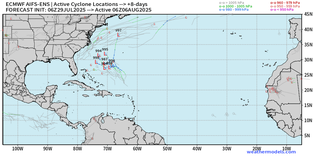
Well, appears the AI models need some more teaching and learning before they can predict tropical storm and hurricane formations. Andy Hazelton @AndyHazelton 1h Central Atlantic waves are pretty convection-free at the moment, as background stability and dry air suppresses rising motion. Not surprisingly, there isn't much model signal for development anymore - the AI models seemed to have been overzealous. For now it seems like physics-based models (e.g. GFS, Euro, and their ensembles) are still our best bet for sniffing out potential TC formation.
.thumb.png.2c30e7e960ed14b6503819a777f1e9e0.png)
-
Things should start to ramp up a bit
-
90/74 heat index is 99 at 10:00 AM ugh.
-
I seriously had to look several times because I know that we were in deep purple, but it's intriguing that the map seemed to have updated it even after you copy and pasted it. They definitely lowered rainfall totals in the range of 1 to 3 days. I could still use an inch though.
-
What a look for early August.
.thumb.png.3ec09e2be5118b439842018576cebf60.png)
-
Well, the area of heavier storms weakened as it neared this area, but still managed .25 so that brings me to roughly 1.25 " for the last 24 hours. I am thinking I will let the grass go for two days, even with temps of 94 and 95 with the expectation of rainfall Wednesday night through early Friday morning. Lawn disease and garden blight have been off the charts bad here due to high overnight lows, and very high dew points. Having the lawn dry out a bit will be a good idea.
-
Missed the second round of storms a couple hours ago, but currently looking at another area of heavy rainfall near Calvert Acres and Fair Hill, MD moving generally SE/ESE.


.png.399afdb7bd6f66ddea4afb5be98f80eb.png)

.png.7c450a5d8cab405c01df622dfd50fccb.png)
