

frd
-
Posts
6,135 -
Joined
-
Last visited
Content Type
Profiles
Blogs
Forums
American Weather
Media Demo
Store
Gallery
Everything posted by frd
-
Jan/Early Feb Medium/Long Range Discussion Part 3
frd replied to WinterWxLuvr's topic in Mid Atlantic
Looks like big snow storm potential. Or too early yet ? -
Jan/Early Feb Medium/Long Range Discussion Part 3
frd replied to WinterWxLuvr's topic in Mid Atlantic
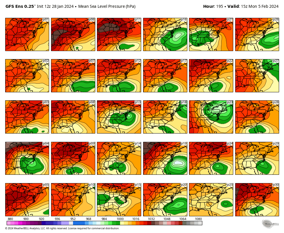
DT update 3:57 PM · Jan 28, 2024 · 9,047 Views WORKING HYPOTHESIS so if we accept the idea that the northern Jet Stream is overdone then the southern LOW is not along the Gulf Coast on FEB 4-5 . It will be back in the Tennessee Valley and the big snowstorm threat is still alive. IMAGE 2 shows the individual 30 members of the 12z GFS Ensemble . Of the 30 members ….13 of them show a significant surface LOW that would bring significant snowfall to the Middle Atlantic region. some of these Solutions also include the northern Mid-Atlantic and New England. Some do not. Given the GFS propensity to overdo the northern branch and suppress southern systems 13 out of 30 is almost 50% which is not bad.
-
Jan/Early Feb Medium/Long Range Discussion Part 3
frd replied to WinterWxLuvr's topic in Mid Atlantic
This would be a plus to hopefully extend or magnify the upcoming pattern change. -
Jan/Early Feb Medium/Long Range Discussion Part 3
frd replied to WinterWxLuvr's topic in Mid Atlantic
Like many have stated, it is still a long ways off given the complicated set-up. -
Jan/Early Feb Medium/Long Range Discussion Part 3
frd replied to WinterWxLuvr's topic in Mid Atlantic
What does the EPS look like at the extended range? -
Jan/Early Feb Medium/Long Range Discussion Part 3
frd replied to WinterWxLuvr's topic in Mid Atlantic
My only concern is time. Simply put when the improved pattern arrives and is established let's look at the date. The later the date, the less likely to possibly achieve seasonal snowfall, or above. Caveat a MECS in which odds are higher in a Nino . -
Jan/Early Feb Medium/Long Range Discussion Part 3
frd replied to WinterWxLuvr's topic in Mid Atlantic
Thanks, I must be impatient. -
Jan/Early Feb Medium/Long Range Discussion Part 3
frd replied to WinterWxLuvr's topic in Mid Atlantic
Appears the undercutting trough developing under the block has slowed significantly the last 48 hours. Atlantic also looks different versus a couple days ago. Maybe require a few additional days to get to a better pattern, or maybe the modeling is simply not correct. Waiting on others to chime in. -
Jan/Early Feb Medium/Long Range Discussion Part 3
frd replied to WinterWxLuvr's topic in Mid Atlantic
You really think that's possible? -
Jan/Early Feb Medium/Long Range Discussion Part 3
frd replied to WinterWxLuvr's topic in Mid Atlantic
DT is excited INCREASING THREAT FOR MAJOR WINTER STORM FOR TENN VALLEY AND MID ATLANTIC FEB 4-5 3:45 PM · Jan 27, 2024 ·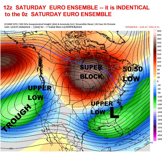
-
Jan/Early Feb Medium/Long Range Discussion Part 3
frd replied to WinterWxLuvr's topic in Mid Atlantic
Been here for many years, and I believe I never remember you being so hopeful. Let's do this !!! -
Jan/Early Feb Medium/Long Range Discussion Part 3
frd replied to WinterWxLuvr's topic in Mid Atlantic
Webb might be on to something. -
Jan/Early Feb Medium/Long Range Discussion Part 3
frd replied to WinterWxLuvr's topic in Mid Atlantic
Thanks, I would hope, and expect as the ops get closer to the extended range modeling the snow mean, given the potential of the pattern should indeed move South and increase. I have not seen any snowfall mean maps recently. I am pumped for what the models are showing. -
Jan/Early Feb Medium/Long Range Discussion Part 3
frd replied to WinterWxLuvr's topic in Mid Atlantic
Did you think by next week 2/3 we begin to see the modeled snow mean start to move South closer to our area, as well as increase? Or, do you think it is still too early? -
Jan/Early Feb Medium/Long Range Discussion Part 3
frd replied to WinterWxLuvr's topic in Mid Atlantic
Maybe once it starts snowing it will not stop. I am on the psu train, edit..... sled I mean -
Jan/Early Feb Medium/Long Range Discussion Part 3
frd replied to WinterWxLuvr's topic in Mid Atlantic
Yep climo, that amount here, plus what has fallen already the last two events would give me a below average snowfall season. Go big, or go home ! Just a snow map of course, the pattern looks very promising, lets hope it delivers like a blend of 1958 and 2010. -
Jan/Early Feb Medium/Long Range Discussion Part 3
frd replied to WinterWxLuvr's topic in Mid Atlantic
March certainly can be a much, much colder and stormier version of December. Shorter wavelenghts, increased odds of late season HL and NAO blocking. I experienced a few wicked March snow events here in the last 15 years. March 2018 I believe was the retro - NAO which lead to 7 F, snowfall and blowing snow, and multiple school clsoings. And, there are other examples too. If things work out as portrayed by the weeklies a version of 2018 could happen. Will be fun to observe the pattern to see what it brings. -
Jan/Early Feb Medium/Long Range Discussion Part 3
frd replied to WinterWxLuvr's topic in Mid Atlantic
This looks much better recently..thumb.png.11b72cb9b0d2bc3a8f8205ee54ccfc72.png)
-
Jan/Early Feb Medium/Long Range Discussion Part 3
frd replied to WinterWxLuvr's topic in Mid Atlantic
Does it still show S/Ws flying around the base way out in La La Land ? I think once achieved this could be a rather active and cold pattern setting up. May have legs too. -
Jan/Early Feb Medium/Long Range Discussion Part 3
frd replied to WinterWxLuvr's topic in Mid Atlantic
Rapidly weakening already set in motion. -
Jan/Early Feb Medium/Long Range Discussion Part 3
frd replied to WinterWxLuvr's topic in Mid Atlantic
LOL. Second time I believe. Don't tell @CAPE Poor Judah, weather does not exsist in a vacum. THE PV and the HL should become more favorable again with a decent Pac and plenty of threats to track I am very excited myself for the period Feb 10 th to March 10 th. -
Jan Medium/Long Range Disco 2: Total Obliteration is Coming
frd replied to Jebman's topic in Mid Atlantic
Of course near President's Day. Looks great. -
Jan Medium/Long Range Disco 2: Total Obliteration is Coming
frd replied to Jebman's topic in Mid Atlantic
And around she goes at a higher amplitude. Moving at a decent pace as well.
-
Jan 15-16 Storm Threat Thread: The Return of Hope??
frd replied to stormtracker's topic in Mid Atlantic
-
Jan Medium/Long Range Disco 2: Total Obliteration is Coming
frd replied to Jebman's topic in Mid Atlantic
Great point, I have heard this before. Looking forward to monitoring this during the upcoming work week.


.png.80d8bfa41582449de3c9f484907e1a9c.png)