

frd
-
Posts
6,988 -
Joined
-
Last visited
Content Type
Profiles
Blogs
Forums
American Weather
Media Demo
Store
Gallery
Everything posted by frd
-
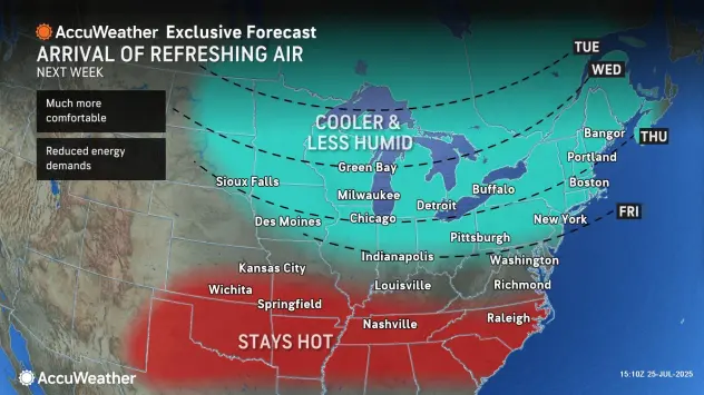
Yes, will be cool to see how it unfolds. meanwhile Accuweather on the cool down bus.
-
92/77 heat index 106
-
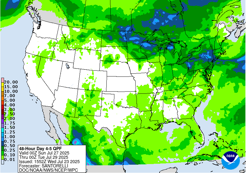
From the WPC Day 6 to 7 By Wednesday and especially Thursday the cold fronts slowly pushing south could provide a focus for enhanced rain amounts in the East, which will be refined in future forecasts.
.gif.41258e502e87fca9504e59742d8f5e4d.gif)
-
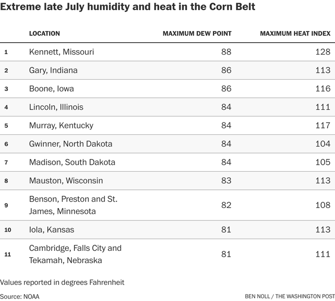
Currently 88/76 here with a heat index of 99. You might think its bad here, thankfully we do not have to deal with corn sweat.
-
Maybe we start to get some better surfing waves by the mid to third week of August, not too crazy please, but maybe just enough to make if more interesting.
-
https://x.com/webberweather/status/1948522507922792876 Interestng read from Webber
-
Mid Atlantic surf zone and offshore SSTs are on fire compared to last year at this time.
.png.637922cb7c33ef783affb04216372f54.png)
-
Pretty much insignificant rain for the Eastern areas, given the high temps and strong sun. Flooding concerns of 6 days ago are not going to happen, things have changed.
-
Very nice outside. Currently 80° with a dew point of 64 and a South wind at 15 mph. Better dog walking weather than last week
-
The WPC has decreased the rainfall potential this weekend, and the 7 day total is generally decreased from the last update.
.gif.b4279a70d6b2e2189419cbf8203745a4.gif)
-
Appears rain chances are decreasing as a result of this overall pattern change.
-
Pretty cool journey this airmass took.
-
If this is correct, this is nuts for July 22 nd. Peak surf zone temps are normally mid to late August. Today's North Wildwood sea temperature is 81.0°F (Which is 7.2°F warmer than normal for this time of year)
-
Ha ha Delaware is the epi center, or in this case the oblong center.
-
Smelled very smokey here this morning near 7:30 A.M. I have not checked, but with the winds NW makes me wonder. For a couple hours it was a very strong smell.
-
Today overachieved the high temp here at 86, Philly hit 87. Looking forward to tonight and tomorrow. Currently 86/61
-
My neighbor works at a local Home Depot. He told me this weekend that the Halloween supplies and kits have arrived and they plan to set up displays soon.
-
Dew point continues to drop now at 62, wow ! But, cloud cover has increased and I see showers on the radar to my far South near extreme Southern DE. Going to time in an outside landscape project tomorrow and Weds AM., only because of the cooler weather and lower dews. Some folks tomorrow morning will be thinking of Fall, with thoughts about Fall coffees, pumpkin comes to mind.
-
@wdrag already mentioning FF pattern concerns up in his area of the NYC forum. Seems the PWATs will be climbing again as we head closer to the weekend.
-
Spoke to soon about heat not reaching extreme levels, there is a possibility we go higher than 95 degrees, however, at this time it appears the highest air temps will be North of us, where the Euro has 100 + heat . It goes without saying that dew points are going to soar again, along with thunderstorm potential.
-
Dew point 66 here presently, love it ! Tomorrow morning should be even better with lower air temps.
-
On X
-
That was a real rainfall producer. Was coming down in sheets, no thunder or wind, just heavy tropical like rains. Dropped .65 here. Grass is happy.
-
Interesting cell near Chesapeake City, MD. moving generally SE.
-
Thats crazy, there is a storm as you mentioned to his NW, to me it looks like in North centreal MD moving East.


