

frd
-
Posts
6,135 -
Joined
-
Last visited
Content Type
Profiles
Blogs
Forums
American Weather
Media Demo
Store
Gallery
Everything posted by frd
-
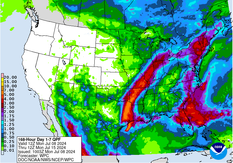
Crazy WPC precip map
.gif.7629fff9358cfc57b596f2384d3c2c67.gif)
-
GFS moving towards the Euro. This stays out to sea most likely, at worse maybe some swells along the East Coast.
-
Nothing versus a forecast of .5 to .75 inches of rain.
-
Some rains for the Northern portion of the area.
.gif.db1e64a60807fb70861a05f9eaf3bd63.gif)
-
Unlikely to effect the area. I would watch for later August regarding a threat, and then again in early October.
-
Another busted rainfall forecast for Delaware. Only area with significant rainfall is Dover, in a East and West orientation, most of the state did not do well at all.
-
Pathetic storms fell apart. Had a severe thunderstorm warning and nothing happened. Storm weakened in a matter of minutes.
- 1,696 replies
-
- 1
-

-
- severe
- thunderstorms
- (and 5 more)
-
2024 Mid-Atlantic Garden, Lawn, and Other Green Stuff Thread
frd replied to mattie g's topic in Mid Atlantic
Rather warm soil temps here presently. Expected soil temperatures for the next 5 days for 19709: 84° 84° 80° 79° 77° 07/16 07/17 07/18 07/19 07/20 -
2024 Mid-Atlantic Garden, Lawn, and Other Green Stuff Thread
frd replied to mattie g's topic in Mid Atlantic
How is it possible your lawn is Ok with the limitied rain that has fallen in your area ? Today I can actually see from 7 AM to right now the lawn is going to heck pretty fast. My area has gotten a lot of rain so I am actually surprised it is going brown and dormant unless what I am seeing might be vast areas of brown spot and dollar spot. Three days ago it was looking great. -
Annapolis, MD (44063) Buoy Report 38.96ºN / -76.45ºW. 81 degrees F. Has really gone up recently
-
Models still have a ways to go. Issues in the winter, issues in the summer. Euro is a mess.
-
Pathetic rains so far, versus forecasts and expectations. But, for SW Delaware and the beaches of Dewey to Rehoboth they are getting slammed. Interesting the Western edge of the rain is drying up on radar. Flood watch until tomorrow Am, so maybe tonight the rain returns.
-
MJO will flip the switch for August.
-
Mount Holly mentions a robust dry slot, but later in the evening and early night when storms might reach further East. Areas N and W could get severe storms earlier near the Fall Line.
-
I have done everything i could do to prevent tomato plant fungus, ie, early blight and seporus or whatever it is called. Water by the roots with no spashing, spreadthe plants apart for air flow, pruning the bottom leaves, put straw under the plant canopy to avoid dirt splashing up spreading fungus spores, and even with all of that I have bad tomato blight already. Been using a cooper spray and it might be helping but today took a turn for the worse. I believe the high dew point and temps do not help at all. Action news in Philly stated three nights ago that in 2024 Philly is experiencing Richmond's climate and Richmond is experiencing Charlotte's climate everything is shifted South by 200 miles. Ugh.
-
This summer will go down as the summer with the most 90 plus days in DC, Baltimore, Philly and Wilmington DE. Dew point here is 78 presently. what a awful summer in the humidity department and of course the heat as well. All the humidity is causing a variety of fungus issues on plants.
-
WPC very bullish on Eastern Seaboard rainfall potential, then a massive shoft West of the WAR combining with the Western US high Pressure system. Looks very hot and tropical down the road. Also, a noticeably rise in western Atlantic SSTs this morning, and looking for that to continue. Would imagine 80 degree F SST in the surf zone later in July.
.gif.81c7dac8a4d42f1a22d3d68c18a4e546.gif)
-
Overnight WPC thoughts on rainfall.
-
Interesting AFD by Mount Holly this morning. It appears the areas for heaviest rainfall is dependent on where the front may stall or slow. Including threat of a Maddox heavy rain event. Lastest guideance has broken the trend and has the front stall further West , so the heaviest rain is to the West. Here is the AFD: Details: Friday into Saturday...Remnant low of Beryl should be well north and weakening/filling by the day time on Friday. However, the previously mentioned cold front will be stalling near or over our region. In the mid and upper levels, a trailing trough will be approaching our region in this period. The biggest concern I have with this period of the forecast is the potential for heavy rain. Not only will precipitable water values remain high (as there will be minimal dry air advection between Thursday and Friday), but this set up has many similarities to a Maddox Synoptic heavy rain event. The front should be stationary (or very slow moving), it has a favored orientation for these types of events, and the winds from 700 to 300 mb should be nearly parallel to the front. This could set the stage for training storms capable of heavy downpours. The main question remaining in terms of the threat specifically to our region is how close the front will get before stalling. Some of the latest deterministic guidance shows it stalling further west, limiting the risk in our region. However, this is a relatively new trend over the past few model runs, and there remains some models depicting the front stalling over our region. Saturday night into Sunday...Front should dissipate, and flow aloft should become mostly zonal. While I can`t rule out some additional storm development, by this point it is unlikely we will see widespread thunderstorm coverage. Another mid an upper level trough could approach as early as late Sunday, but confidence in the timing of that feature is low at this time.
-
Meanwhile the Atlantic continues to cook.
-
Excellent early morning dog walking weather. Almost chilly.
-
Thats sounds like typical West winds or offshore upwelling. Crazy days are possible there.
-
Have you been to the beaches recently? I am trying to figure out why the near land SSTs are still so chilly. We have had some very hot days. Maybe upwelling?
-
Yep, this caught my eye " We remain particularly concerned seeing progged PWat values by both deterministic models and ensembles in the range of 2.25 to 2.5 inches which is again is close to climatological maxes. " Never posted this, but the last rain event produced training cells delivering 2.55 inches of rain and the night before 1.52 inches. This was preceded by a dew point of 79 here. The atmosphere will once again be primed on Saturday to deliver big rainfall totals. I hope this time more folks in our forum are able to get significant rainfall.
-
GFS trending North to Texas.

