

frd
-
Posts
6,461 -
Joined
-
Last visited
Content Type
Profiles
Blogs
Forums
American Weather
Media Demo
Store
Gallery
Everything posted by frd
-
Ponder this, a weak Nino maybe in early 2020
-
Just one piece of the puzzle. Seem as though we still not have reached the min bottom yet.
-
Wonder about the association with the min and the implications
-
We lost the - NAO and so begins the record + that will last until April 2020 . And yes I do think it had a role in the summer not going super hot at times, when it was at its deepest negative. Even though a lackluster -NAO is suppose to have no effect on cooling the NE section of the country. We had record drops. Some say a delayed response to the late season warmingh event. And, of course the Cold pool that had exsisted was also a factor. Which if I may add is viewed as a signal for the winter ahead that a averaged -NAO may occur.
-
Yep, it stinks I am pondering pushing off the over seed that I had targeted for next weekend to late September. For now it appears we transition to a above normal temp regime after mid-month. Don S believe the data points to a warm Fall overall. Of course it is still early to tell for sure. The weeklies as Don mentions supports the warmer temps. I mean it does seem the general way we roll is a warm Fall . And to go with that with the exception of last March , March has been more wintery than Decembers have been recently. Sort of like it takes time to get the ball rolling and the effects of blocking tend to show up later in the winter season. Maybe some things at play this Fall will change that. At this time I am hoping we maintain Nino forcings. The QBO will be telling as well, as one piece of many that we need to look at in the months ahead. I would also look for hints in terms of the MJO and the amplitude, in view of the SH SSWE and the effects on the tropics. Of couse too, is the possibility the CFS has regarding the Pac and the Nino in the months ahead. Here is the update Don posted : he SOI was -15.27 today. Today, the preliminary Arctic Oscillation (AO) figure was +0.225. Since 1950, there have been five prior cases when the AO averaged -0.500 or below in both July and August: 1950, 1958, 1960, 1968, and 2015. The average temperature for September was 69.1° (69.8° after adjusting for ongoing warming) and 58.9° (59.6° adjusted) for September through November in New York City. The 1981-2010 baseline normal figures are 68.0° and 57.5° respectively. The majority of cases saw a warmer than normal September and all cases featured a warmer than normal fall. Therefore, a warmer than normal September and fall appear likely, though the persistence of Dorian's impact on the larger circulation has reduced the probability of a warmer than normal September. Nevertheless, a warm monthly anomaly remains the base case. The potential for autumn 2019 to rank among the 30 warmest cases on record remains on the table. The latest EPS weeklies are hinting that an extended period of above to much above normal readings could prevail after mid-September. On September 6, the MJO was in Phase 5 at an amplitude of 1.154 (RMM). The September 5-adjusted amplitude was 1.228. Based on sensitivity analysis applied to the latest guidance, the implied probability of New York City having a warmer than normal September is approximately 58%.
-
Crazy stuff at the South Pole and in general the SH SSWE
-
SOI continues to stay negative and today broke recent trend line Average SOI for last 30 days -7.80 Average SOI for last 90 days -7.03 Daily contribution to SOI calculation -20.92
-
I too reflected on last winter here, sorry to bring it up..... I need therapy..... :-) Now on to the chase.....
-
The December + SOI should have been taken as a warning sign that the pathetic Nino was needing some Viagra . But, like most, I too believed in the seasonal models and the weeklies. Of note as well was the high amp MJO in the warmer phases, just an out of syn winter. Another hallmark last winter was the raging Pac jet that set several records.
-
Some interesting things now as far as the IOD and the negative and decling trend of the SOI. Seems like a Nino background state continues. Also of note, the Summer look at 500 of a typical Nino signature. A nice match. Will be a very interesting Fall to track the way things progress. By the way, as pointed out by bluewave a couple weeks ago, the warm blob was a new record, much warmer than it ever was back in the previous two upward peaks.
-
Well, yes we did but the long awaited blocking in the AO domain never materialized as the models thought it would. ( late Jan through March was when the weeklies and other seasonal guidance forecasted the legit and mouth watering AO and NAO blocking developing ) Add to that the lack of a Nino background state, and we had little snow and not so much cold. The Pac was more Nina at times. The list goes on and on as to why this happened. The reason for the Euro's failure was most likely it not seeing the lack of the Nino response as it was more Nina, it never caught on that the atmosphere and ocean was not coupling. If you look at the Euro's summer seasonal forecast it did rather well across the US.
-
Study on the NAO ...... since you mentioned the NAO and this coming winter https://agupubs.onlinelibrary.wiley.com/doi/10.1029/2019GL084402 Research Letter Open Access Seasonal Predictability of the Winter North Atlantic Oscillation From a Jet Stream Perspective First published: 19 August 2019 In contrast, the slow, decadal variations in both latitude and speed are not captured, despite the pronounced multidecadal variability in jet speed in the reanalysis. This suggests that different processes are responsible for NAO variability on the decadal timescales, and hence that there may remain untapped sources of NAO skill, particularly on the longer timescale. The flip side of this, however, is that forecasting skill on the seasonal timescale in a model may not automatically translate to skill on longer timescales. The models in general have a reasonable simulation of the Atlantic jet and its variability in latitude and speed, albeit with some discrepancies in individual cases. However, there is not a clear link between a model's simulation of the jet mean state characteristics and its skill in a prediction sense. For example, the ECMWF SEAS5 model was found to have the best representation of the jet latitude and speed distributions, but yet was not found to have significant skill in predicting either of these quantities or the NAO. This suggests that the major problem in this case lies not in the internal jet stream dynamics but in the pathways by which predictable drivers affect the jet stream. It is interesting that, despite higher skill in predicting the NAO than other systems, the U.K. Met Office seasonal prediction system, GloSea5, appears to misrepresent the close link between the NAO and the jet indices. This could be important, since the jet latitude dominates the observed NAO, and has also been identified here as the clearest source of NAO skill. This discrepancy could contribute to the signal‐to‐noise issue in GloSea5, as predictable signals in jet latitude may not translate to as large a signal in terms of NAO index in the model as in observations.
-
September 2019 General Discussions & Observations Thread
frd replied to Rtd208's topic in New York City Metro
Wonder if we can approach weak Nino vs cool or neutral. Seems the SH SSWE may be effecting the MJO and the tropics as well. The + IOD is very impressive . -
Many remember the Modaki and moderate Nino during the great winter of 09-10, but some forget the blocking we had as well. No wonder great winters are only so often. But yes, as CAPE pointed out, the gold standard of Ninos would be the moderate Modaki type.
-
Simple impressive SSTs , I do feel this will have implications for the Fall and early Winter.
-
September 2019 General Discussions & Observations Thread
frd replied to Rtd208's topic in New York City Metro
@bluewave Do you foresee any effect from the sustained downturn in the SOI for the East later in Sept? SOI Dashboard Latest Southern Oscillation Index values SOI values for 7 Sep, 2019 Average SOI for last 30 days -6.34 Average SOI for last 90 days -6.71 Daily contribution to SOI calculation -15.27 Monthly average SOI values Jun -9.99 Jul -5.86 Aug -3.14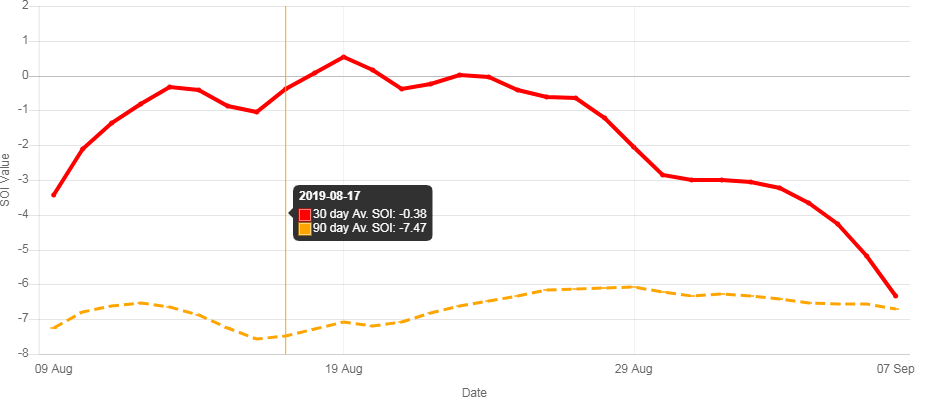
-
This is hopeful to see. Might go along with the weak PV idea .
-
As Amy mentions this means little for the upcoming winter, but I imagine it can not hurt.
-
There are indications of just that going forward. Might be on to something, unless the CanSIPS was hacked .
-
A previous Euro monhly had a chilly October
-
If the Euro weeklies can't get it right how can you trust seasonals , IMHO they are all useless. However, with global warmth this could certainly be one option of many. At least JB can't spin this as a cold Eastern winter look because the warmth is so extensive.
-
Secondary cell dropping in as well now Special Weather Statement National Weather Service Mount Holly NJ 750 PM EDT Wed Sep 4 201 DEZ001-002-MDZ008-012-050030- Kent-New Castle-Cecil-Kent- 750 PM EDT Wed Sep 4 2019 ...A STRONG THUNDERSTORM WILL AFFECT SOUTHWESTERN NEW CASTLE... NORTHWESTERN KENT...NORTHEASTERN KENT AND SOUTHEASTERN CECIL COUNTIES... At 750 PM EDT, a strong thunderstorm was located near Hollywood Beach, or 8 miles east of Aberdeen Proving Ground, moving east at 20 mph. Wind gusts up to 50 mph and pea size hail are possible with this storm. Locations impacted include... Middletown, Clayton, Cecilton, Warwick, Sassafras, Green Spring, Bohemias Mills, Delaney Corner, Cayots, Massey, Hollywood Beach, Townsend, Galena and Odessa. If outdoors, consider seeking shelter inside a building.
-
Cell that hit my area is now warned, exiting DE, and headed across the DE River to Salem County , NJ Severe Weather Statement National Weather Service Mount Holly NJ 745 PM EDT Wed Sep 4 2019 DEC003-NJC011-033-050015- /O.CON.KPHI.SV.W.0387.000000T0000Z-190905T0015Z/ New Castle DE-Cumberland NJ-Salem NJ- 745 PM EDT Wed Sep 4 2019 ...A SEVERE THUNDERSTORM WARNING REMAINS IN EFFECT UNTIL 815 PM EDT FOR SOUTHWESTERN NEW CASTLE...NORTHWESTERN CUMBERLAND AND SOUTHWESTERN SALEM COUNTIES... At 745 PM EDT, a severe thunderstorm was located over Middletown, moving east at 20 mph. HAZARD...60 mph wind gusts and quarter size hail. SOURCE...Radar indicated. IMPACT...Minor damage to vehicles is possible. Wind damage to roofs, siding, trees, and power lines is possible. Locations impacted include... Bridgeton, Middletown, Alloway, Quinton, Greenwich, Shiloh, Hancocks Bridge, Newport Meadows, Hope Creek, Mount Pleasant, Seabrook Farms and Odessa. PRECAUTIONARY/PREPAREDNESS ACTIONS... For your protection move to an interior room on the lowest floor of a building. Frequent cloud to ground lightning is occurring with this storm. Move indoors immediately. Lightning is one of nature`s leading killers. Remember, if you can hear thunder, you are close enough to be struck by lightning.
-
Only a few places within 100 miles of me have it . One is in Elkton , MD., so that is rather close to me . Will be purchasing the Ultra I think. I am excited to try it. Looks like the weather turns cooler for a long while, so will try to get going on this in the next 10 days, the issue is renting the machine, I have not done that yet. The storm tonight would have washed everything away had I over seeded already. Fine line, as you mentioned, between mother nature and rain ( too much too quickly ) and being able to control the water with timed sprinklers .
-
Got very, very lucky here. Lone cell dropping some heavy rain with winds up to maybe 35 mph...this could open the door for me to over seed now .

