frd
-
Posts
6,130 -
Joined
-
Last visited
Content Type
Profiles
Blogs
Forums
American Weather
Media Demo
Store
Gallery
Everything posted by frd
-
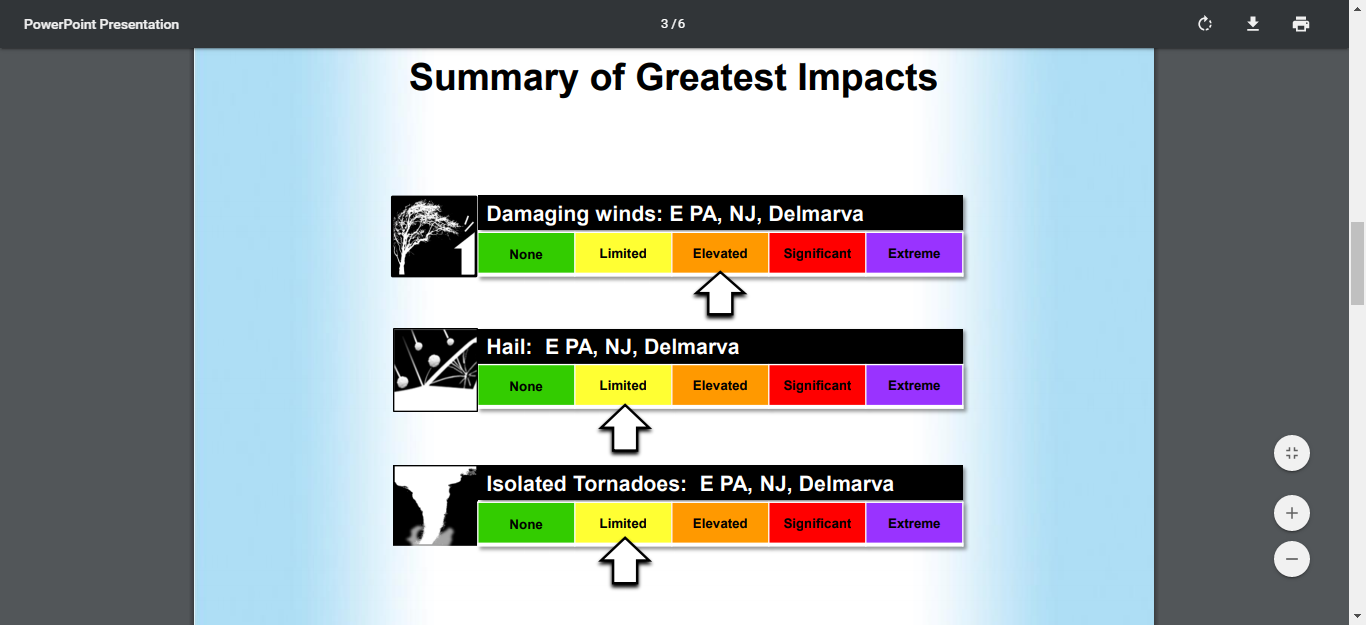
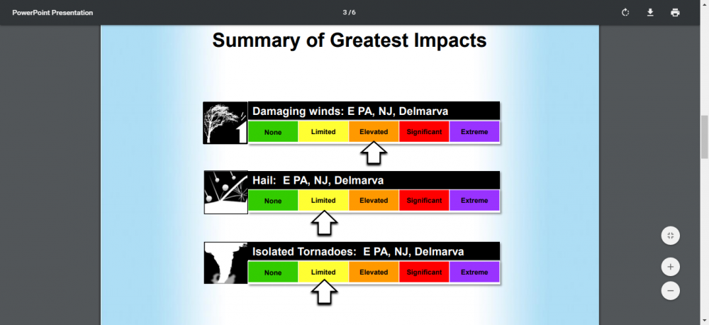
From Severe briefing NWS Mount Holly released this AM. For the NE part of the sub forum
-
I know your insight is much valued. But, maybe we can at least get some rainfall. In this case for the plants.
-
Wow, never knew that Moderate Risk only averages once every three years. That explains a lot about the frequency of severe weather in our parts.
-
Seems the HRRR idea of the mid afternoon storms having more impact than the Midwest complex slated for evening has gained a "bit" more support. But, as Mount Holly NWS states the Midwest complex needs to be watched Great job by Mount Holly in the discussion this AM. covers everything in detail ! This is just a snippet .NEAR TERM /UNTIL 6 PM THIS EVENING/... 630 update: Showers and thunderstorms will continue to move across northern portions of the forecast area (generally along and north of I-78) for the next couple hours. Occasional bursts of moderate rain will be the main concern with these AM storms. Regarding the stronger storm potential later in the day 06Z guidance has trended a bit more towards the HRRR solution in the morning discussion e.g. an initial line of stronger storms passing through the area mid-afternoon and then less activity in the evening (generally missing the area to the north). Consequently the line of storms currently extending through the Midwest will bear watching.
-
I know, but just mentioning be careful what you wish for. Already my garden is totally dry and top soil is very hard. It is amazing how quickly we lose ground moisture this time of year. Once-a- week rainfall would be awesome, but 14 days in summer in a row without rainfall is not great, if you have agriculture concerns, or have a garden. etc. Need to get my soaker hoses set up and straw or mulch the garden, it is about time shortly. Less rain has one advantage- less mosquittos - I hate them !
-
For my area Mount Holly has only about a 40 % chance of storms . A few days ago there was agreement a line would form and move East from I-95 up this way, and head East to the shore. What actually happened was a Dover, DE and further South scenario. I am not sold on a widespread event and think any significant severe is way North. One thing though, surface moisture after the heat and winds and low dews - getting dry. After this next oppurtunity little in the way of rainfall. And the SE is dry and super hot. I have noticed the trend for the dryness spreading West in time as well. Maybe the next wet cycle is June, when exactly , not sure.
-
Mount Holly update at 330 PM NEAR TERM /UNTIL 6 AM TUESDAY MORNING/... A very warm/hot and also humid afternoon in progress with some areas closing in on 90 degrees, however the dew points have dropped a little mainly along the I-95 corridor. An upper-level trough will continue to shift eastward through tonight from the Great Lakes, adjacent Canada and New England. Low pressure will track well to our north, however its cold front crosses our region through early this evening. As the cold front arrives, it may combine with a lee side trough. The convection allowing models (CAMs) generally agree that convection continues to develop, especially around the Philadelphia metro southwestward. In addition, some other convection will continue to develop especially near terrain influences and near the residual lee side trough. As of 19z, only some showers with no lightning being detected as convective development is shallow thus far. Visible satellite imagery does show some taller cumulus near and west of I-95. For now went no higher than scattered convection (chance PoPs), as the overall organization should be lacking. The latest mesoscale analysis shows around 500-1000 J/KG of MLCAPE and this should increase to around 1500 J/KG by late afternoon. The 0-3KM shear ranges from 30-40 knots with the strongest across the far northern areas. Some strong storms are anticipated with a few potentially going severe. There is some dry air aloft and combined with steeper low-level lapse rates results in better DCAPE and potentially strong surface winds. Locally strong to damaging wind gusts are possible, however this threat looks to be with any robust convective cores as precipitation loading will enhance the downdraft. There is not a lot of forcing, thus convection will be driven by the airmass and the incoming surface front. Once the cold front shifts offshore early this evening, the convection will end with clearing taking place. Cold air advection increases in the wake of the cold front, and this should keep some wind going from the northwest. This will also result in a cooler overnight, especially as the dew points drop into the 40s for much of the region by daybreak. Low temperatures are mainly a MOS/continuity blend.
-
Pretty crazy sounding there
-
I believe I read many schools have been cancelled in the high risk areas today out West due to the nature of the forecast, timing of the storms, and the probabilities of extensive severe weather and tornadoes.
-
Marginal risk today, here but wow to the High Risk in Oklahoma and Texas. Going to be some incredible videos coming from that area. I am sure some of the best storm chasers in the country are there today, as it has been talked about for over a week, due to the high potential for large and long track d tornadoes.
- 2,802 replies
-
- 1
-

-
- severe
- thunderstorms
- (and 4 more)
-
From Mount Holly for today, and I noticed a 90 degree reading possible in Southern Delaware. Looks like severe potential lower but the odds of getting into some thunderstorm activity better than yesterday 000 FXUS61 KPHI 201026 AFDPHI Area Forecast Discussion National Weather Service Mount Holly NJ 626 AM EDT Mon May 20 2019 .SYNOPSIS... A cold front associated with low pressure moving through the Great Lakes into Canada will cross our region this afternoon and evening. High pressure is then expected for Tuesday into Wednesday. A warm front arrives in our area late Thursday night and Friday, followed by a cold front on Saturday which may stall to our south on Sunday. .NEAR TERM /UNTIL 6 PM THIS EVENING/... A quiet start to the morning after a muggy and humid night. Temperatures will once again be on the rise, with most places making it into the mid to upper 80s. Portions of southern Delaware and the Eastern Shore of Maryland may in fact reach 90. Slightly cooler along the shore and in the higher terrain of the Poconos with highs in the mid to upper 70s. Another chance for showers and thunderstorms this afternoon as a cold front moves southeastward across the mid-Atlantic. The severe threat appears to be lower than yesterday, though non- zero. The Storm Prediction Center has our area under a Marginal Risk for severe thunderstorms. Instability looks to be lower than yesterday with ML CAPE values forecast to top around 2000 J/kg. Shear will be a little lower as well, with 0-3 km shear forecast to be less than 30 knots, thus a little less supportive of stronger thunderstorm cells. With the timing of the front, storms look to fire a little further southeast than yesterday, likely initiating along the Delaware River Valley by 4 to 5 pm and moving offshore by 9 to 10 pm. There could be some localized flooding concerns in areas that see brief heavy rainfall, but storm motion should prevent as much training as was seen yesterday.
-
Wow to Monday for Texas and OK., it might be an awesome day. Some signals are really historic for the potential of severe weather and tornadoes out there.
- 2,802 replies
-
- 1
-
-
- severe
- thunderstorms
- (and 4 more)
-
This is pretty cool from Ventrice.
- 2,802 replies
-
- 1
-
-
- severe
- thunderstorms
- (and 4 more)
-
Line forming and moving East now https://radar.weather.gov/ridge/radar_lite.php?rid=lwx&product=NCR&loop=yes
-
I read we are nowhere near the low point of the still progressing solar minimum.
-
Long range has potential, after the 15 th.
-
Wow, an incredible collection of videos within that link, thanks for posting mappy !
-
Getting brighter here currently. Mount Holly thinks the warm front may reach as far North as Philly by late afternoon. May need to watch the Delmarva later. from AM update FXUS61 KPHI 031344 AFDPHI Area Forecast Discussion National Weather Service Mount Holly NJ 944 AM EDT Fri May 3 2019 Another shortwave trough will begin approaching the region by late afternoon and into the early evening hours. Thus, this time frame will be a focus for scattered showers and a few thunderstorms to develop. Currently not expecting and of these storms to be severe, but given modest instability during the late afternoon, cannot rule out a rogue strong storm or two perhaps reaching severe criteria, particularly across Delmarva.
-
Record Number Of Top 10 Warmest Months Since 2010
frd replied to bluewave's topic in New York City Metro
@bluewave Do you feel the general warmth and especially the warmth in the recent fall months, Sept and October mostly, has been associated with the above average SST off the East Coast and the nature of the WAR. A sort of feedback taking place possibly which also plays a role in moisture transport up along the East Coast and warmer over night lows via higher dews. Any thoughts? Thanks ! -
Same here CAPE, I missed any rotaton to my North but of note was the intense rainfall so loud in fact that is blocked out the thunder which was almost a constant hum. I was in a warned area though. This storm did not compare at all with the rather intense cell (s) we had earlier this week. The one that hit us at 2:45 AM and lasted unabated until 3:15 AM. Constant winds over 35 gusting to 60 That was a every 4 year storm to me. The winds should dry things nicely tomorrow , maybe cut the grass again.
-
Damn this might be close .... Weather Statement National Weather Service Mount Holly NJ 429 PM EDT FRI APR 26 2019 MDC015-029-262100- /O.CON.KPHI.TO.W.0007.000000T0000Z-190426T2100Z/ Kent MD-Cecil MD- 429 PM EDT FRI APR 26 2019 ...A TORNADO WARNING REMAINS IN EFFECT UNTIL 500 PM EDT FOR NORTH CENTRAL KENT AND SOUTHEASTERN CECIL COUNTIES... At 429 PM EDT, a severe thunderstorm capable of producing a tornado was located near Betterton, or 7 miles southeast of Aberdeen Proving Ground, moving northeast at 45 mph. HAZARD...Tornado. SOURCE...Radar indicated rotation. IMPACT...Flying debris will be dangerous to those caught without shelter. Mobile homes will be damaged or destroyed. Damage to roofs, windows, and vehicles will occur. Tree damage is likely. Locations impacted include... Elkton, Cecilton, Betterton, Warwick, Sassafras, Bohemias Mills, Newtown, Brantwood, Cayots, Hollywood Beach, Kennedyville, Chesapeake City and Galena. PRECAUTIONARY/PREPAREDNESS ACTIONS... TAKE COVER NOW! Move to a basement or an interior room on the lowest floor of a sturdy building. Avoid windows. If you are outdoors, in a mobile home, or in a vehicle, move to the closest substantial shelter and protect yourself from flying debris. Heavy rainfall may hide this tornado. Do not wait to see or hear the tornado. TAKE COVER NOW! If a tornado or other severe weather is spotted, report it to the National Weather Service or your local nearest law enforcement agency who will send your report. This act may save lives of others in the path of dangerous weather.
-
Tornado Warning Tornado Warning MDC015-029-035-262030- /O.NEW.KPHI.TO.W.0006.190426T2001Z-190426T2030Z/ BULLETIN - EAS ACTIVATION REQUESTED Tornado Warning National Weather Service Mount Holly NJ 401 PM EDT FRI APR 26 2019 The National Weather Service in Mount Holly NJ has issued a * Tornado Warning for... Northern Queen Anne`s County in northeastern Maryland... Kent County in northeastern Maryland... Southwestern Cecil County in northeastern Maryland... * Until 430 PM EDT. * At 401 PM EDT, a severe thunderstorm capable of producing a tornado was located over Bodkin Point, moving northeast at 35 mph. HAZARD...Tornado. SOURCE...Radar indicated rotation. IMPACT...Flying debris will be dangerous to those caught without shelter. Mobile homes will be damaged or destroyed. Damage to roofs, windows, and vehicles will occur. Tree damage is likely. * Locations impacted include... Chestertown, Rock Hall, Betterton, Newtown, Morgnec, Kennedyville, Langford and Kingstown. PRECAUTIONARY/PREPAREDNESS ACTIONS... TAKE COVER NOW! Move to a basement or an interior room on the lowest floor of a sturdy building. Avoid windows. If you are outdoors, in a mobile home, or in a vehicle, move to the closest substantial shelter and protect yourself from flying debris. Heavy rainfall may hide this tornado. Do not wait to see or hear the tornado. TAKE COVER NOW! To report severe weather contact your nearest law enforcement agency. They will send your report to the National Weather Service office in Mount Holly NJ. This cluster of thunderstorms is capable of producing tornadoes and widespread significant wind damage. Do not wait to see or hear the tornado. For your protection move to an interior room on the lowest floor of a building. &&
-
Heard a water spout crossing the Chessie SE of Baltimore
- 2,802 replies
-
- 1
-
-
- severe
- thunderstorms
- (and 4 more)
-
That last enhanced risk for my area was like a mini derecho. Where as that line hit at 2:45 AM this looks like maybe 6 PM here. I am hoping for no downed trees, finally got the yard looking nice. Will be an interesting late afternoon. Also, just like the last time, the winds will be stong tomorrow around the area, however, doubt we get the high wind advisory, but you never know. The last advisory was posted rather late. Has been an active April for sure .
-
To some the weekend has started early. Many folks I know are off tomorrow.