frd
-
Posts
6,135 -
Joined
-
Last visited
Content Type
Profiles
Blogs
Forums
American Weather
Media Demo
Store
Gallery
Everything posted by frd
-
January: Medium/ Long Range: May the Force be with Us....
frd replied to Weather Will's topic in Mid Atlantic
The warm Atlantic has been mentioned in this possible connection. The NAO block the is forecasted may very well linked with the SER diminshing the benefits of the NAO block. Hence the favorable patterm in the long range never happens, but that is too soon to worry about. -
January: Medium/ Long Range: May the Force be with Us....
frd replied to Weather Will's topic in Mid Atlantic
First time in a million years I have seen the AO drop like this heading into prime climo in our area, and right after the Winter solstice as well. Past examples of this timing had the cold locking in for a while, combined with storminess. Cold temps arriving with likely odds in early Jan., along with signals that support SECS. Watch the -AO drop even before the EOY..thumb.png.42a9c97e44756b959d95daeddac2b4ec.png)
-
Great post by Tomer on the pattern evolution going forward. I like it ! mentions the word snow .... https://x.com/burgwx/status/1870246071852572678
-
Well, with the cup 1/2 full, ratios would be much higher.
-
All we can ask is being in the game.
-
Big changes start during this time frame as alluded to you and @CAPE https://x.com/bamwxcom/status/1869713225148686705
-
Canada is also well above normal with some of their anomalies in excess of 30 degrees above normal. That indicates no further cold intrusions for the U.S. for the foreseeable future.
-
Euro 18Z https://x.com/BradyBGWX/status/1869170215990469060
-
Cloudy here, thought the forecast was mostly sunny.
-
From BAMM WX, explanation regarding the Euro AI outcome. https://x.com/bamwxcom/status/1866927389604995170
-
Not looking good, and when it gets colder in early 2025 Tomer states the pattern only supports a clipper in the East. Tomer states similiar to the early December pattern with below normal temps, but also below normal precip. https://x.com/webberweather/status/1865454685676806338 https://x.com/webberweather/status/1865454685676806338
-
Annual Christmas period warm up may not happen this year. Would break tradition going back many years. Most encouraging is the pattern forecased later month, but even more is not seeing the rapid rise in the AO and snow cover is not going to be eroded in the source regions such as in years past.
.thumb.png.7dedd49fedbf1acbb7af1a34f9f28e45.png)
-
As for the AO, it has been closer to normal, at times going negative. I am more concerned with the Pac for our chances of cold and snow in the Mid.Atlantic.
.thumb.png.cebaae36fc317899c0f34679e380d8ae.png)
-
By that time we here in the lowlands are in a better climo spot.
-
If that happens you can kiss Jan good bye. Once the Western Canadian souce region is scoured of cold air it will take weeks for the entire process to reverse. Of course speculation, but persistance the last 5 to 7 years. Have to wee if Webb is correct about Jan. I could less about the-NAO and the -AO its all about the +PNA/ +TNH.
-
27
-
Does the Euro bias of burying energy in the SW still exist after all these years ?
-
Would think a clipper is one good option, in addition to what you mentioned.
-
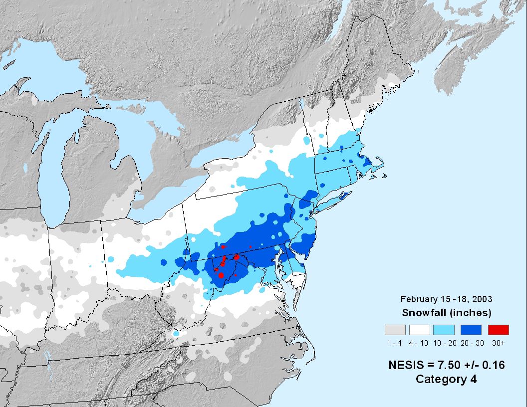
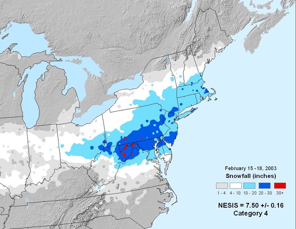
More of a concern if the winds were really sustained from the East for a long period of time. But, yes presently the Atlantic SSTs have been above normal for some time this Fall. + 2 to + 6 degrees F. Of note, the great Blizzard of 2003 even turned to sleet here at the end, because of 1,000 mile fetch of ENE winds coming off the off the Atlantic at 35 to 45 mph.
-
I believe the Euro is over-rated. Have to look at verification scores, but in the past ten years I believe the GFS, and its ensembles, tend to do better in the Northern stream backdrop.
-
Not the first time strong highs up North did not funnel in colder air to our region. However, maybe that will change with future model runs, as snow cover is increasing up North while the NAO is not going crazy positive.
-
Fits @psuhoffman analog set for this coming winter. Expect the cold, but most were not snowy years.
-
Having a decent source region is something we have lacked for a long time. Also, SE Canada is going to have a large increase in snow cover over the next couple weeks.
-
The most you can determine might be a favorable window. Not too mention, but a Nina with an active Northern jet is extremely difficult to model in the long range. Expect the unexpected.
-
In past Decembers when it was cold, we tended not to cash in on the cold. However, the chill will lend to the holiday season. There is still potential beyond the 10 day period, I like the window from Dec. 7 th to the 10 th.

.png.a1e8b1699f8a53ba5207425f306efdf4.png)


.png.f87a2602d806d31de8deb33abc405ace.png)
.png.1f2d2ff6a91a2ef60a54964aa2cc910c.png)