frd
-
Posts
6,208 -
Joined
-
Last visited
Content Type
Profiles
Blogs
Forums
American Weather
Media Demo
Store
Gallery
Everything posted by frd
-
Mount Holly has increased their rainfall forecast compared to yesterday. I have not looked at the modeling, but it looks like there's a better chance of rainfall now.
-
Still snowing to our North.
-
1.78 inches here. Chilly out there this morning. Tomorrow is Rehobeth's 5 K. Good luck to those participating including my daughter. Next after this is the Broad Street run in Philly. Sunday morning hopefully better than this morning at the beach.
-
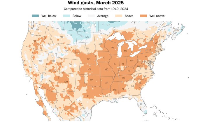
I thought even for March it was very windy.
-
Long range models look to delivery yet another cold blast next week. Frost and freeze threat is not over.
-
We will issue a Freeze Watch for most of our Delmarva counties (with the exception of the Delaware Beaches and New Castle County DE) since the growing season is considered to have officially started there. In the tier of zones just to the north and east, the start date isn`t until the 11th.
-
The favored corridor that existed during the winter going across the central Eastern shore to Dover and slightly South seems to be the same area this morning receiving the better rainfall. Rain has picked up in intensity here recently. Looks to continue for several more hours. The grass is excessively tall. Looking forward to 35 to 40 mph wind gusts tomorrow to help dry things out.
-
Significant rainfall chance next Friday and Saturday.
-
Higher elevation snows on Tuesday possible, also snow showers to the far NW. A secondary cold front Monday night may end up moving through our area with little in the way of precipitation with it as the deeper moisture is shoved offshore with the earlier front. Given the strength of the incoming upper-level trough however, cannot ruled out some lingering light rain showers (snow showers across the far northwest) Monday night and early Tuesday morning. Low temperatures by Tuesday morning will be mainly in the 30s. While temperatures in the mid 30s are forecast all the way south into Delmarva, it will be too windy and dry for any frost formation.
-
https://x.com/RyanMaue/status/1907793713801077104 Damn that SE ridge ! Several days of deep layer moisture feed out of the Caribbean and Gulf into the lower/mid-Mississippi River Valley leading to extreme rainfall totals. Blame the "high pressure/ridge" off Southeast U.S. coast for blocking traffic and directing the massive atmospheric river.
-
Looking like a wet weekend pattern going forward. Also, no way to be able to mow or do early crops.
-
Very small area of clearing. Moving across Northern northeastern Maryland into Northern Delaware won't last long, but temperatures have come up a bit since the sun has showed itself
-
Looks like .28 here
-
Getting hit rather hard this morning. Initial line of storms maybe 4:00 a.m. secondary line of storms that were stronger hitting the area around 6:10 a.m.
-
Mostly NW of us. But, better than nothing, just wish it would not be cloudy every day.
-
Yes, yesterday was chilly on dog walk, going out now should be much better, 74 here presently. The clouds though are just stubborn and I need sunshine, even just a little.
-
OMG how depressing this weather is, and its only just begun.
-
Ryan Maue @RyanMaue · 27m 26 concurrent tornado warnings as major outbreak escalates
-
JB celebrates the cold rain.
-
Clearing made it, sunny now, temps going up !
-
Interesting. If sun comes out was going to mow the lawn. If not later Tuesday. Not many nice days in the forecast. Appears to be a very active end of week with more clouds and chances of rain.
-
Mount Holly thinks its a good bet we go up towards 80 in the Delmarva zones. We shall see. Front did make it much further South than anticipated. The biggest challenge for today will undoubtedly be the temperature forecast. A big "boom or bust" temperature day for those in the vicinity of the frontal boundary. The frontal boundary has made it much farther south, and with much more potency than previously expected. Given this trend, the high temperature forecast was lowered by several degrees for areas near, north, and east of the Philly metro. Delmarva should easily climb back into the upper 70s to near 80 degrees again.
-
Decent area of clearing moving from West to East. Wondering if it make it to us, if so, it would warm up rather quickly from Philly South.
-
Maybe a thunderstorm tomorrow evening or overnight From Mount Holly this morning : skies are expected to be mostly cloudy Monday but temperatures are still forecast to warm into the low to mid 70s. The cloudy skies will also helping limit daytime heating and overall instability with MUCAPE values largely less than 1000 J/kg. However, there will be very strong dynamics and shear in place, so much of the area remains in a SLIGHT risk of severe weather from the Storm Prediction Center, mainly for damaging wind gusts within severe thunderstorms. It is also worth noting, however, that the 0-1 km shear and helicity look to be quite high so a tornado or two will be possible. Confidence on this is lower though. The best chance for some severe weather will come during the afternoon and early evening while the heavy rain threat will be highest through the mid to late evening into the early overnight hours as storms tend to grow upscale and instability becomes more elevated.
-
Yesterday outside and landscaping with zero bugs, today everything is out, I liked yesterday way more !