

KAOS
-
Posts
1,536 -
Joined
-
Last visited
Content Type
Profiles
Blogs
Forums
American Weather
Media Demo
Store
Gallery
Everything posted by KAOS
-
Storm Reports
-
Seeing and liking that as well.
-
This is going to be nearly impossible to complete. Changelog..... Level of Difficulty = " * " Added global geo search bar * Fixed problem with duplicated search bar requested resulting in reply of null. (SDK 1.8.4) *** Remove lightning strikes from severe group. (SDK 1.8.4 breaks this feature). ** Added custom ANIMATED lightning strikes using MapsGL Shader. ***** Added button to layers panel for custom lightning strikes. ********** Reorganized buttons and groups in layer panel. **** Fixed problem with occasionally inconsistent button and group placement in layer panel. **** Reconfigure alerts to use traditional NWS color fill. ***** Moved alerts below areoway-line. *** Alert stroke, fill, color and opacity adjusted and are programmatically adjustable. **** Fixed issue with alerts flashing white at end of animation. *** Fixed issue with satellite, etc. preventing animation reload upon activation/deactivation. These are now static images... animation automatically re-enabled upon close. **** Update and optimize multiple JAVA SCRIPT SDK versions to co-exist with minimal conflict and other issues. (using JAVA SCRIPT SDK 1.3.5 and 1.5.2) **** Added Storm Threats Info panel option programmatically. Soon to be selectable between info panel and storm panel via button controls. ** Added custom intellistar button link. ** Re-styled auxiliary buttons. * Updated timeline (animation) control time frames (max -12 hours to NOW) ** Updated timeline animation speed. *** Reconfigure default time line selection to -2 hours. ** Adjusted opacity, fill, stroke, size, color for all layers. **** Reconfigure layer loading order. ** Reconfigure listing order of data inspector. *** Added "Feels Like" menu item to the data inspector (combination of wind chill and heat index data in a single element) * Added storm cells and storm reports to data inspector. **** Fixed issue with missing layer info in data inspector upon zoom in. (All versions of JAVA SCRIPT SDK versions 1.4.X have this issue) *** Added latitude and longitude variables to html address for intellistar geo location purposes. *** Added storm cell and lightning heat maps to layers and layer panel buttons. * Added location to default info panel. * Added animated earthquakes. *** Reduced width of geo search bar. * Far too many things to list. But I will work on it. TBC.
-
Storm Mode update incoming.... It is impossible to encapsulate all of the features in a single image.
-
Maybe I should bring back the ha9000 emulator. You could talk to it and have it reply just stuff like all this "new" stuff. I did this in the 90's. But way more basic.... Q: What time is it? A: It is 8:57 p.m. Q: How are you? A: I am good, KAOS. All systems are operational. https://y.yarn.co/142e22cb-b12c-4de3-b67a-324b746110d7.mp4
-
BTW... most phones/tablets/browser have a way to create an "app" from a url address. Usually an option like "add to home screen". This way your screen real estate is not consumed by the url bar etc. Basically full screen mode for phones, etc. Equivalent to F11 on desktop/laptop. Something like this... https://www.androidauthority.com/add-website-android-iphone-home-screen-3181682/ Or this... https://hermit.chimbori.com/ With proper settings, only the app will fill the screen. View in landscape mode. Those are my mobile tips.
-
I will now add some additional complexity. Since I am not constrained by the typically limited hardware and data resources available to most mobile devices.
-
Update: fixed issue with radar icon button link (local radar slide in emulator). Was not passing geo info from currently selected emulator location...which then prompted setting menu for location. Existing links are updated. No user interaction required. NOTE: In almost all cases you can continue to use the same previously provided links...automatically updated. Though you may need to clear your browser cache.
-
Can confirm. Where you been?
-
Waiting for... "Now I am even more confused."
-
It is has been cloudy here most of the day... very few peaks of sunshine.
-
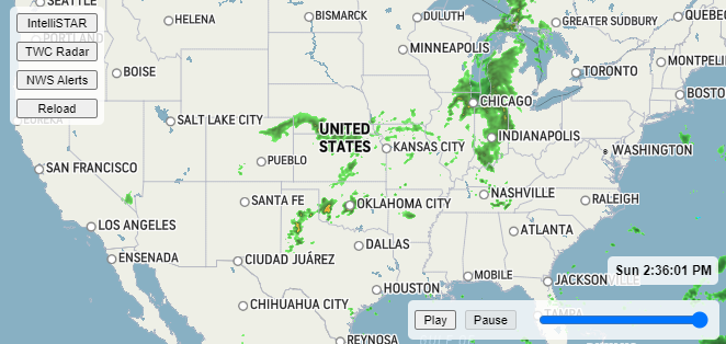
FYI... for those who may be confused. This is my GIFT to you guys. It is not just a "weather map"... it is an interactive, animated, weather application and twc instellistar emulator using java script while utilizing both css and html code... retrieving and resolving multiple data sets via API's globally. No ads, no b.s... hosted on one of my github accounts. You simply click on the links provided and it "should" work. Let me know otherwise.
-
As I work on a desktop version, I will stop at this point to post a "Desktop Lite Version". This should run well on any Desktop/Laptop or reasonably recent Mobile device. https://kaosfactory.github.io/desktopliteX1.html
-
-
The primary add on in the emulator relies on the emulator's geoinfo. Which means it does not work on it's own. I have created a standalone version. This is best used on mobile... but can be used on desktop as well. As with almost everything here mobile, it works best in landscape view. https://kaosfactory.github.io/MOBILE_APP_STANDALONE.html
-
Here is a link to the Desktop App with custom alerts. The alerts are opaque translucent with opaque outlines. Color coding change as well. All warnings shall be red, etc. Additionally they are placed below the aeroway-line layer on the map. This increases the visibilty of road names, etc. https://kaosfactory.github.io/WX_APP_customalerts.html
-
Thanks guys. It really has been quite a bit of work. I think it turned out fairly well. Most of the hard work is done. That said, there are still some details I want to iron out. I will be updating links as I progress. The next major project will be creating a dedicated Desktop Version for the Emulator. I am so glad to be mostly done with the mobile stuff. It is a pain in the ass.
-
And here is an updated link for the mobile version of the intellistar emulator with new and improved add-ons. Can be used on desktop as well. https://kaosfactory.github.io/mobileX1.html
-
-
Here is an updated link for the Desktop weather app with features shown above... https://kaosfactory.github.io/WX_APP.html
-
Test... https://kaosfactory.github.io/screenshots/MaximumEffort.mp4
-
I added earthquakes...
-
Or harvester of sorrow.


