

Birds~69
-
Posts
34,362 -
Joined
-
Last visited
Content Type
Profiles
Blogs
Forums
American Weather
Media Demo
Store
Gallery
Posts posted by Birds~69
-
-
32 minutes ago, LVblizzard said:
How has Patullo not been fired yet? What is Lurie waiting for?
It's rare they fire in season coaches when you have a pretty good record. But the writing is/was on the wall. If he's back next year I'm going to punch a Dallas fan, cut into small pieces, throw through a wood chipper,light on fire then dispose of the remains in the Schuylkill River!!
-
 1
1
-
-
17 hours ago, JTA66 said:
I often think how improved my quality of life would be if I wasn’t interested in sports and didn’t like snow.
I can't tell you how much time I wasted on sports and weather in my life. Maybe not wasted, but I probably could have used it more efficiently.
That being said, I will continue to do so which is more screwed up...
-
 2
2
-
-
2 hours ago, JTA66 said:
My immediate overreactions...
Howie needs to retool the O-line. I know we couldn't keep everyone from last year's squad, but I felt all along he dropped the ball there.
KP gone, no brainer. But for the first time I'm questioning Jalen. To be clear, I like him. I'm not a hater. But a lot of ppl smarter than me are questioning if he's capable of running the type of offence the Eagles want to run. I don't study game tape or am smart enough to understand the deeper x's and o's of football. I'm not saying its time to move on from him (it would be a cap disaster if we did). Just wondering it's time to start asking the question about his long-term future here.
AJ. Time to move on as well. He clearly looks mentally checked out. I had a Ricky Watters/Wally-Gator arms flashback after that first incompletion to him, "for who, for what?" But at only 28, is he also physically diminished? He certainly didn't look elite this year -- not getting separation, not coming down with 50/50 balls. Plus it looks like when he's in the line up, Jalen forces to ball to him to keep the peace.
Just my random thoughts. As Paul said, Go Phils!
Real quick for the Phils, sign Bo.
Birds again, KP should be canned immediately. Running quarterbacks such as Hurts have a short time span as far as running. I don't think he's horrible but he can't run like a 22 year old. And I wish his field vision was better. He doesn't see wide open receivers when it's obvious on the replay.
Birds have some work to do...
-
20 hours ago, JTA66 said:
Elliot…ARE YOU FOOKING KIDDING ME!!
He won't be back next year, AJ is gone, Lane may retire. I have trust in Howie to go balls to the wall this off-season....
-
12 hours ago, Ralph Wiggum said:
@Birds~69 rough night with the game and the models.
AJ is likely gone in the off season. KP needs to go. After replacing AJ, maybe snag some depth at receiving as well (cant just be davante Smith). Otherwise I dont think they are a horrible squad. Just inept on offense.
It's hard to believe that they are so horrible on offense. Having a top receiver in AJ and a top running back in Barkley and can't do squat. And the play calling is just horrible. So damn vanilla. Lane may retire or in a year or so. Howie likes drafting offensive lineman so that's probably on his list. Overall, a real drag of a season. It seemed like they could never get their shit together...
-
6 minutes ago, JTA66 said:
12z Euro does a little sumthin’ sumthin’
I always like a little something something but my priorities today are etched in stone.
1.Birds
2.Birds
3.Peak at models
Worst case scenario? Birds get trounced and blow torch models with no good news in sight....
-
Incoming rain junk heading in. Dark-gloomy-ominous looking clouds outside...
50F/Going to be a raw night/Sat

-
7 hours ago, Ralph Wiggum said:
Geese were flying due East today....lots of them. What's that all about?
Same here. And there was about a hundred or so pecking at the grass on a baseball field at a local high school.
-
9 minutes ago, ChescoWx said:
Have not hit freezing here the last 2 nights- tonight will be our 3rd straight....
I didn't even notice, I thought we did.
-
13 minutes ago, ChescoWx said:
Have not hit freezing here the last 2 nights- tonight will be our 3rd straight....
Yeah, you're right, same. I thought we just made 32F but apparently not.
-
51F/Looks like we may not go below freezing tonight...
-
-
6 hours ago, Mikeymac5306 said:
I was there yesterday. It was cold.
Backups played like.... backups. No one was really into the game. I seriously hope they are done with Sidney Brown and Keelee Ringo. Two major busts.
Another game where the Eagles beat the Eagles. Self-inflicted penalties and sloppy play calling. Gonna be a quick game next week if the play calling is the same.
McKee is who he is. Probably would be better with the #1 team but...
Classic Ringo yesterday...
-
 1
1
-
-
12 minutes ago, Ralph Wiggum said:
Enjoying the day and vegging out to old Weather Channel clips and zoning off to the old local on the 8s music. That management group doesn't know if they just brought that segment back with that smooth jazz style.misic what a goldmine they would have.
Anyway, this 1994 clip popped up. What a brutal and cold winter that was:
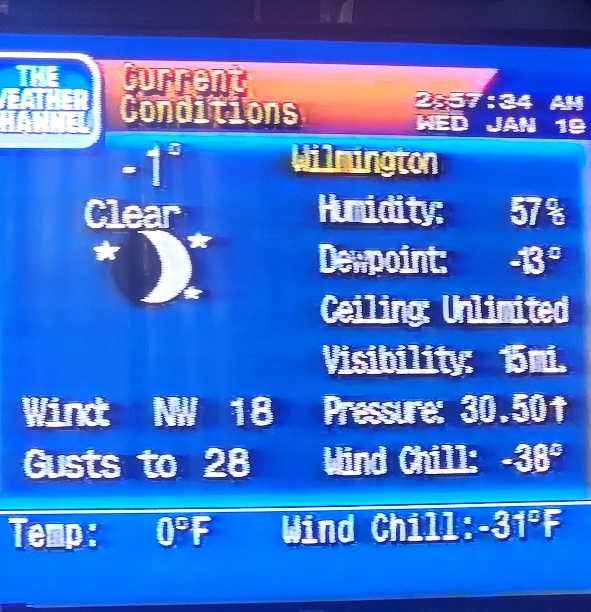
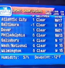
Floyd's "Shine on you crazy diamond" and "Take five" by the Dave Brubeck Quartet were my two favorites...
-
1
-
-
I swear I wish Seth was a coach in some capacity for the Birds...
-
2 hours ago, Ralph Wiggum said:
I actually miss the days we would get a steady rainstorm with times of driving rain...for 48 hrs...and finish with 3-4" of rain. Feel like that used to be common once if not twice a year.
How do you think drought guy feels? He probably dreams about this several times a week only to wake up with nothing besides anxiety and cold sweats...poor guy.
33F/mostly cloudy
-
 2
2
-
-
21 minutes ago, PhiEaglesfan712 said:
I'm not really mad about last night's loss. I'd much rather the loss yesterday than next week. If the Eagles had won last night and lost next week, it would have been all for nothing. At least if the Eagles win next week, then everything is forgiven.
It's not like we had a perfect home season to defend. (I'm still a bit annoyed that we lost the last game of the 2017 season to the Cowboys before winning Super Bowl LII, but it's been forgiven.) Besides, we kept the 11-win regular season streak alive, and have a chance to tie 2000-04 next year.
Not for me. If they win against the 49ers then go on the road and lose. I'll say to myself that should have been a home game....
-
12 minutes ago, Mikeymac5306 said:
I was there yesterday. It was cold.
Backups played like.... backups. No one was really into the game. I seriously hope they are done with Sidney Brown and Keelee Rongo. Two major busts.
Another game where the Eagles beat the Eagles. Self-inflicted penalties and sloppy play calling. Gonna be a quick game next week if the play calling is the same.
McKee is who he is. Probably would be better with the #1 team but...
The 49ers are last in the league at generating sacks so Hurts "should" have time. And their run D isn't all that stellar either so Barkley "should" get some yards. If they can't generate points Patullo needs to be canned and the offensive play calling revamped...
Birds 3 point favorites...
-
2
-
-
10 hours ago, RedSky said:
Is it common practice for a team with second seed up for grabs to rest starters i wouldn't think anybody would do that.
It's not common practice. Nick probably thought he could rest the starters and still win w/the backups. Also, showcase McKee who they'll probably entertain trade talks in the offseason. Everything pretty much failed...
-
1
-
-
1 hour ago, Birds~69 said:
Nick is going to hear shit if the eagles lose the second seed because he rested the starters.
Bears losing 13-0 (good), Birds down 10-7 (bad). Both games at the half...
WIP overload tonight. Fire Nick will be the theme....
-
Nick is going to hear shit if the eagles lose the second seed because he rested the starters.
Bears losing 13-0 (good), Birds down 10-7 (bad). Both games at the half...
-
27 minutes ago, The Iceman said:
Huge Dan Campbell fan, he’ll have his guys ready to play. Enjoy the week off of tracking, after Monday we get a nice warm up for a few days to defrost before heading back into the freezer the following week. I’m hoping I can squeeze a day at the golf range before the rain next weekend.
Although I like the cold and winter weather, a week break is nice once in a while (but no more!) I can catch up on things without freezing my ass off every time I go outside.
Still some nice mounds in the parking lots which my weenie eyes observes probably too often. An accident waiting to happen especially in parking lots where people have their head up their asses searching for parking spots which are literally 5 ft closer than an already open spot....
33F/partly sunny
-
11 hours ago, Ralph Wiggum said:
Jan 2016 storm I think I started a week out. That was a well-modeled storm.
And more times than not it doesn't pan out. Either the precipitation is down or the rain snow line is trending toward the Poconos.
I have high blood pressure. No sense of stressing myself for 5 days following models 24hrs/day when I can do it in 3.
Looks like we have about a week+ of probably nothing. Maybe I'll get some shit done.
Go Birds and let's get the number two seed today...hope all the Bears players have the flu and can't play.
29F
-
3
-
-
1 hour ago, penndotguy said:
Im good with it as long as no one starts a Storm thread outside of 5 days that's grounds for therapy.
That's even pushing it. 3 days out is fine by me...
-
1
-
Philly Area Banter
in Philadelphia Region
Posted
KP is done! There's a reason everyone is pissed on offense! I may blow torch him after I light him on fire... maybe grind him afterwards? He is useless....