Birds~69
-
Posts
34,363 -
Joined
-
Last visited


-

E PA/NJ/DE Summer 2026 Obs/Discussion
Birds~69 replied to PhiEaglesfan712's topic in Philadelphia Region
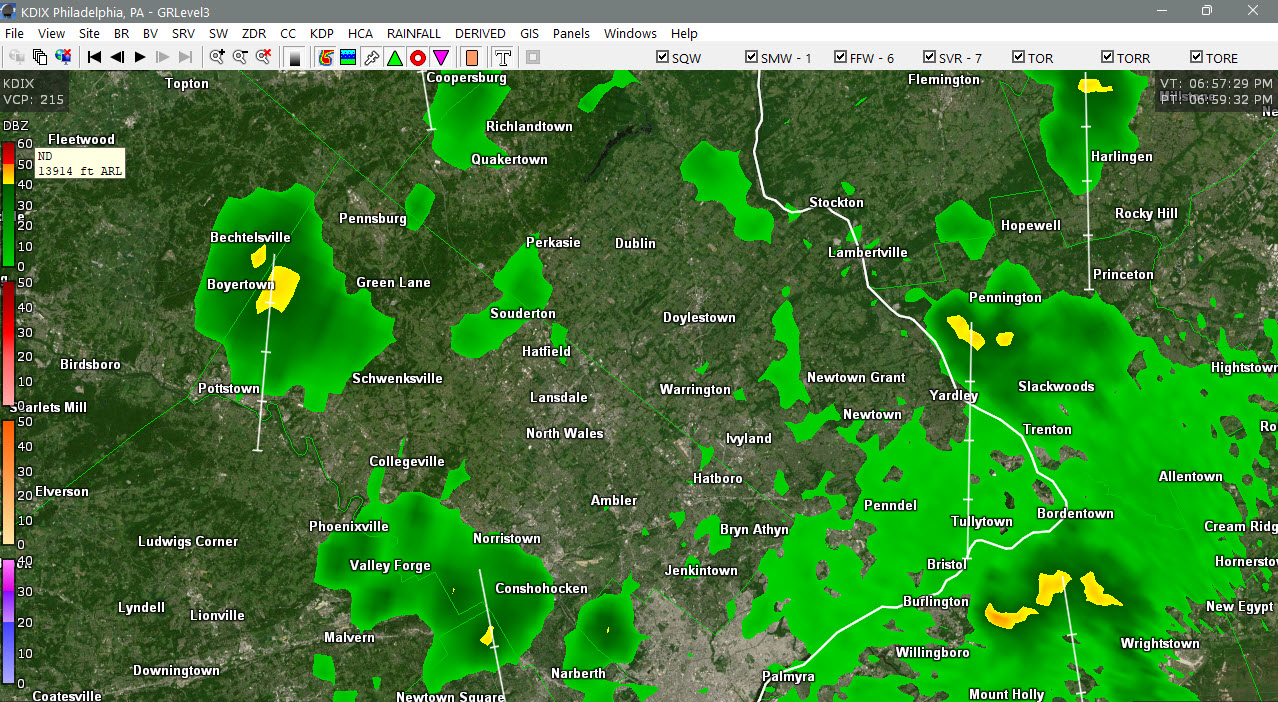
There will be some heavy downpours today. Tropical feel outside...something has to give. -
E PA/NJ/DE Summer 2026 Obs/Discussion
Birds~69 replied to PhiEaglesfan712's topic in Philadelphia Region
84F/DE 72F Stuff from the S moving up... -
E PA/NJ/DE Summer 2026 Obs/Discussion
Birds~69 replied to PhiEaglesfan712's topic in Philadelphia Region
Preseason games start later since they went from 4 to 3 preseason games. Birds 1st preseason 8/15/Ravens...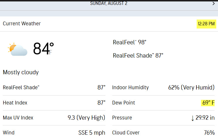
-
E PA/NJ/DE Summer 2026 Obs/Discussion
Birds~69 replied to PhiEaglesfan712's topic in Philadelphia Region
79F/DP 71F at 9:40am Another sign Fall is on the way is someone had lawn chairs down by the curb for trash pick up. Probably old/broke and they will pick up new ones on clearance in a few weeks for next year. Smart move. Anyhow, we need some refreshing air (DP 50s)... -
E PA/NJ/DE Summer 2026 Obs/Discussion
Birds~69 replied to PhiEaglesfan712's topic in Philadelphia Region
May/should reach 90F.... 3:30pm
-
E PA/NJ/DE Summer 2026 Obs/Discussion
Birds~69 replied to PhiEaglesfan712's topic in Philadelphia Region
72F/DP 71F Temps haven't been bad but the DPs have sucked... -
E PA/NJ/DE Summer 2026 Obs/Discussion
Birds~69 replied to PhiEaglesfan712's topic in Philadelphia Region
A couple downpours around if you're lucky... 75F/DP 67F
-
E PA/NJ/DE Summer 2026 Obs/Discussion
Birds~69 replied to PhiEaglesfan712's topic in Philadelphia Region
78F/DP 65F Almost below 50...
-
Pay no mind. Take the kids outside for a catch or something...
-
Yep, agree. Just the ominous, loud "death is near" sound gets people's attention...
-
E PA/NJ/DE Summer 2026 Obs/Discussion
Birds~69 replied to PhiEaglesfan712's topic in Philadelphia Region
Don't want the first three. They are no-nos...2nd tier nonsense. From Phillyburbs: Three meteorologists on staff are potential candidates: Karen Rogers, who handles weekday mornings; Adam Joseph who is on weekday afternoons; and Brittany Boyer, who joined the team in 2021 and works weekends and some weeknight shifts. Is there any speculation that former 6ABC weatherman Chris Sowers is returning to his former employer? Sowers moved back to the area, leaving his job with a Florida station earlier this year, but seems content to blog about the weather at this point through his YouTube channel and Facebook page. 76F/DP 67F -
E PA/NJ/DE Summer 2026 Obs/Discussion
Birds~69 replied to PhiEaglesfan712's topic in Philadelphia Region
AI would get all fancy w/the clouds and ruin my day. Keep it retro and I'm in... -
E PA/NJ/DE Summer 2026 Obs/Discussion
Birds~69 replied to PhiEaglesfan712's topic in Philadelphia Region
Whenever I see a 7" report in a relatively short time I always think of TS (Pink) Floyd... -
E PA/NJ/DE Summer 2026 Obs/Discussion
Birds~69 replied to PhiEaglesfan712's topic in Philadelphia Region
Did they announce yet because he would irk me....see ya Ch6 if so. -
E PA/NJ/DE Summer 2026 Obs/Discussion
Birds~69 replied to PhiEaglesfan712's topic in Philadelphia Region
Was surprised, no doubt but makes sense. She's loaded, why not enjoy life before the dreaded If it wasn't announced yet her replacement will probably be a female although I would give Chris Sowers a call since he's back in the area and a snow guy... 73F/Damn DP 72F