Rjay
-
Posts
27,594 -
Joined
-
Last visited
Content Type
Profiles
Blogs
Forums
American Weather
Media Demo
Store
Gallery
Everything posted by Rjay
-
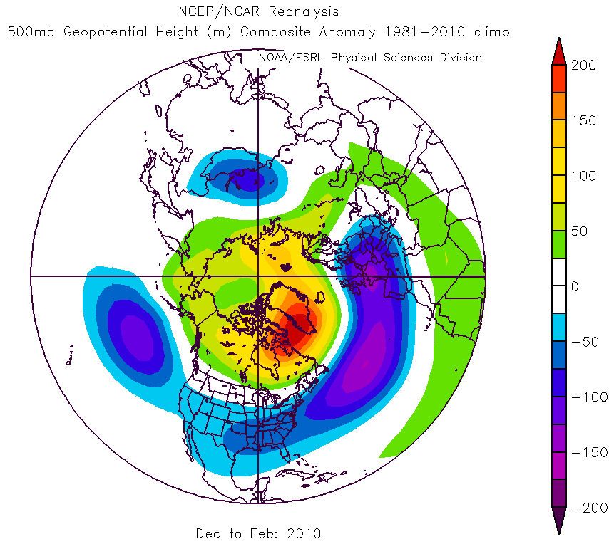
Dec 2009 to Feb 2010 What a time to be alive

-
If anyone has anything good from the Feb 13th, 2014 insane front-end dump they should post it
-
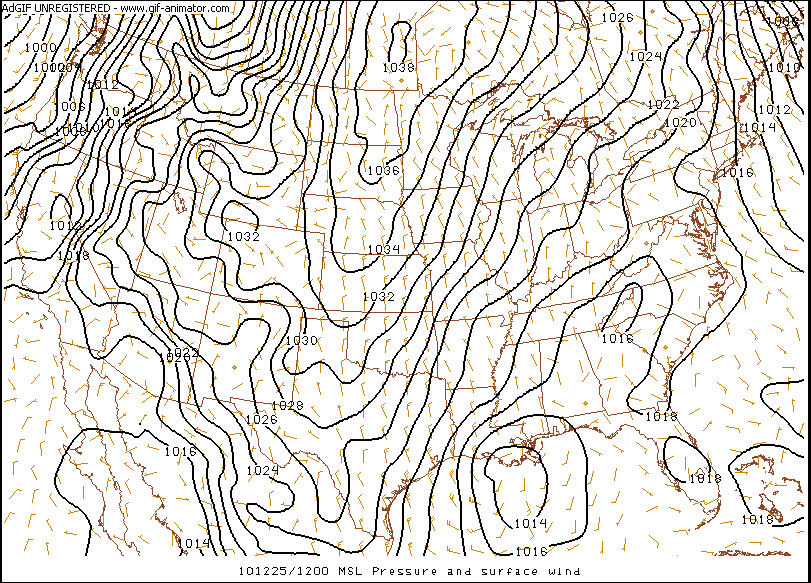
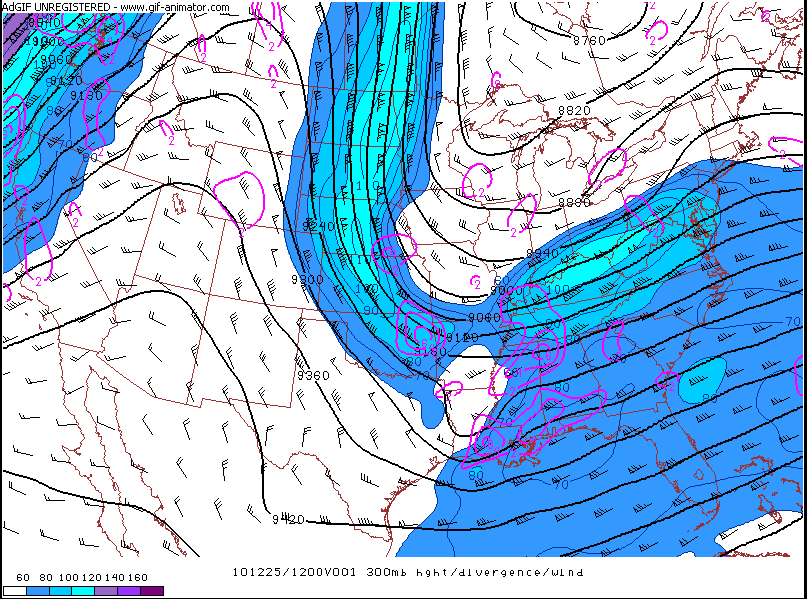
The models completely missed how far west this beastly northern steam s/w would be. It dropped due south out of Canada. The GFS caught it first.
-
HPC went on to toss the next 3 gfs runs and tossed the NAM's next 3 runs as well.
-
From the NWS in Taunton LONG TERM /SATURDAY NIGHT THROUGH THURSDAY/...HIGHLIGHTS* POTENTIAL WINTER STORM SUNDAY THROUGH MONDAY.SPECIAL NOTE AT 1140 AM...WE HAVE GOTTEN A GOOD LOOK AT THE 12ZNAMAS WELL AS A QUICK LOOK AT THE 12Z GFS THROUGH TUESDAY /SO FAR/. WEHAVE SEEN THE DRAMATIC TREND THAT THE GFS HAS TAKEN ON THIS RUN...ASWELL AS THE W TREND ON THE NAM/THOUGH REMAINING WELL S OF THEBENCHMARK/. WE WANTED TO NOTE THAT WE HAVE RECEIVED MESSAGES FROMHPC ABOUT INITIALIZATION PROBLEMS ON BOTH THE NAM AND GFS RUNS THISMORNING. HAVING WORKED ON THIS DESK FOR THE LAST SEVERAL DAYS...ONETHING THAT HAS SHOWN THROUGH IS THE LACK OF RUN-TO-RUN CONSISTENCYBETWEEN INDIVIDUAL MODELS. WHILE WE ARE NOT RULING OUT A SHIFT TOTHE W...WE DO NOT WANT TO JUMP ON THE BANDWAGON EITHER. WANT TOWAIT UNTIL WE GET A LOOK AT THE ECMWF RUN BEFORE MAKING ANY MAJORCHANGES
-
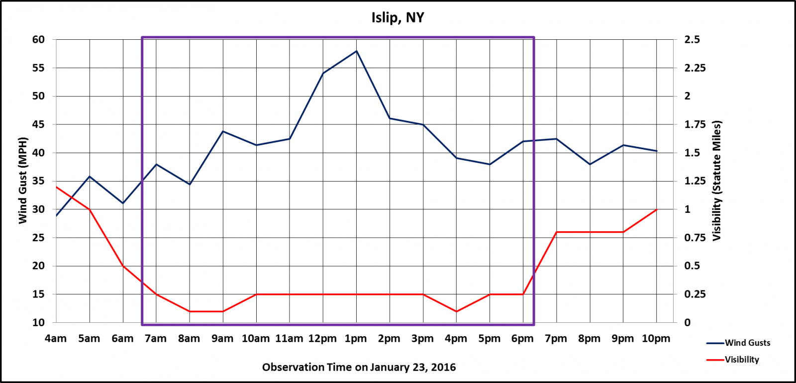
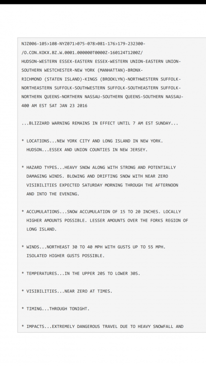
Upton usually updates throughout every storm. In most of pur big ones they started at 6-10". The totals would creep upward with every update. Here's a random one from Jan 2016.
-
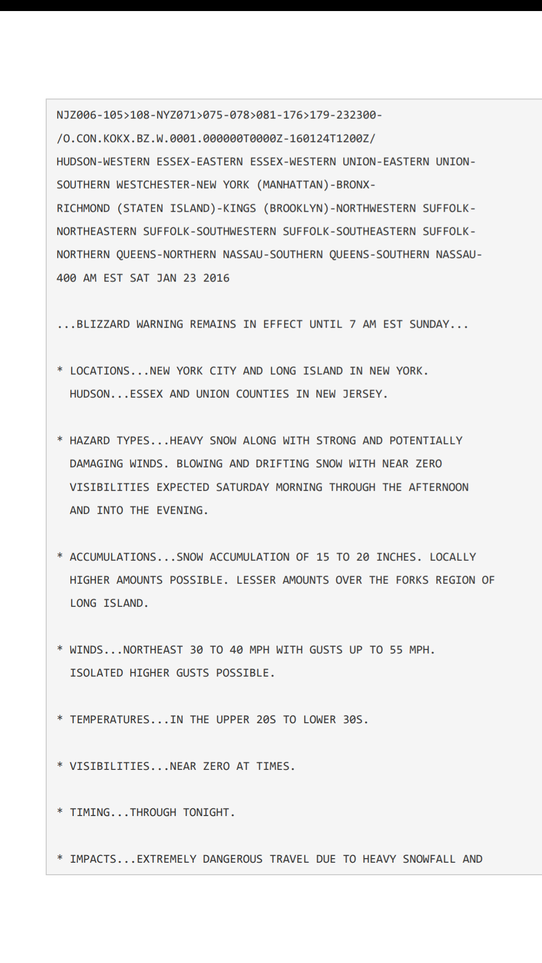
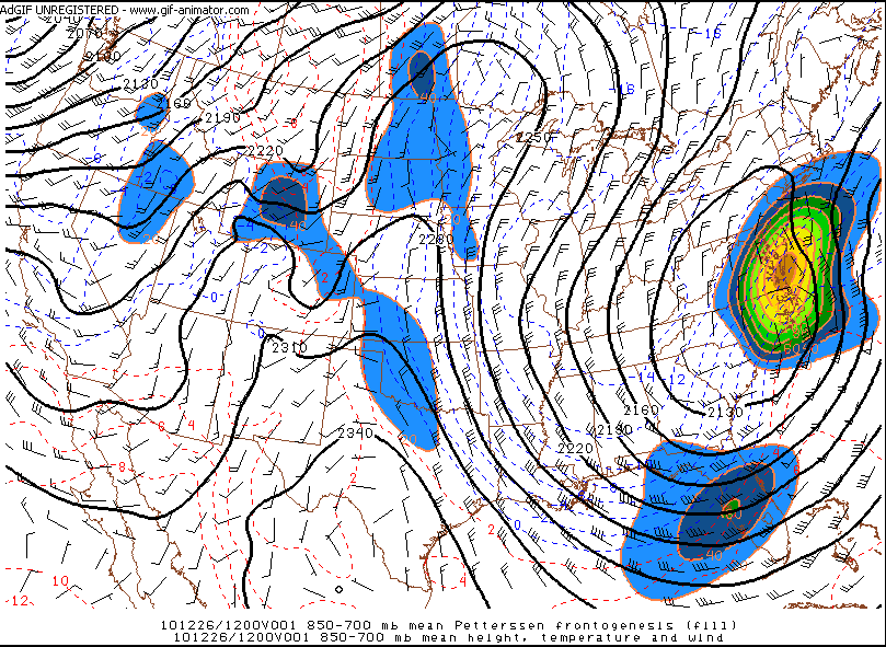
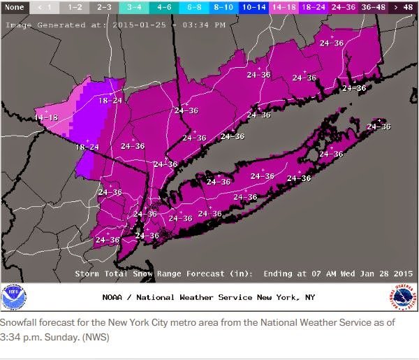
URGENT - WINTER WEATHER MESSAGE NATIONAL WEATHER SERVICE NEW YORK NY 1138 PM EST SUN DEC 26 2010 ...DANGEROUS WINTER STORM OVERNIGHT INTO MONDAY... NJZ002-004-006-103>108-NYZ067>070-074-271245- /O.CON.KOKX.BZ.W.0002.000000T0000Z-101227T2300Z/ WESTERN PASSAIC-EASTERN PASSAIC-HUDSON-WESTERN BERGEN- EASTERN BERGEN-WESTERN ESSEX-EASTERN ESSEX-WESTERN UNION- EASTERN UNION-ORANGE-PUTNAM-ROCKLAND-NORTHERN WESTCHESTER- RICHMOND (STATEN ISLAND)- 1138 PM EST SUN DEC 26 2010 ...BLIZZARD WARNING REMAINS IN EFFECT UNTIL 6 PM EST MONDAY... A BLIZZARD WARNING REMAINS IN EFFECT UNTIL 6 PM EST MONDAY. * HAZARDS...HEAVY SNOW AND STRONG WINDS...WITH CONSIDERABLE BLOWING AND DRIFTING OF SNOW WITH NEAR ZERO VISIBILITY AT TIMES. * ACCUMULATIONS...18 TO 24 INCHES...WITH LOCALLY HIGHER AMOUNTS UP TO 30 INCHES POSSIBLE. * IMPACTS...EXTREMELY DANGEROUS TRAVEL CONDITIONS DUE TO SIGNIFICANT SNOW ACCUMULATIONS...AND STRONG WINDS CAUSING CONSIDERABLE BLOWING AND DRIFTING OF SNOW. VISIBILITIES WILL BE NEAR ZERO AT TIMES...WITH WHITEOUT CONDITIONS EXPECTED. STRONG WINDS MAY ALSO DOWN SOME POWER LINES...TREE LIMBS...AND CHRISTMAS DECORATIONS. * TIMING...SNOW WILL BE HEAVY AT TIMES OVERNIGHT...WITH POSSIBLE RUMBLES OF THUNDER. THE SNOW WILL TAPER OFF FROM WEST TO EAST LATE TONIGHT. STRONG NORTHWEST WINDS WILL PERSIST THROUGH MONDAY AFTERNOON. * WINDS....NORTH WINDS OF 25 TO 40 MPH WITH GUSTS UP TO 55 MPH ARE EXPECTED THROUGH LATE TONIGHT. PRECAUTIONARY/PREPAREDNESS ACTIONS... A BLIZZARD WARNING MEANS SEVERE WINTER WEATHER CONDITIONS ARE EXPECTED OR OCCURRING. FALLING AND BLOWING SNOW WITH STRONG WINDS AND POOR VISIBILITIES ARE LIKELY. THIS WILL LEAD TO WHITEOUT CONDITIONS...MAKING TRAVEL EXTREMELY DANGEROUS. DO NOT TRAVEL. IF YOU MUST TRAVEL...HAVE A WINTER SURVIVAL KIT WITH YOU. IF YOU GET STRANDED...STAY WITH YOUR VEHICLE.
-
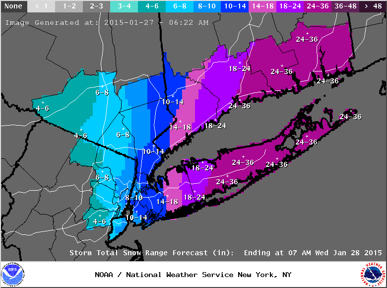
Closer to reality...
-
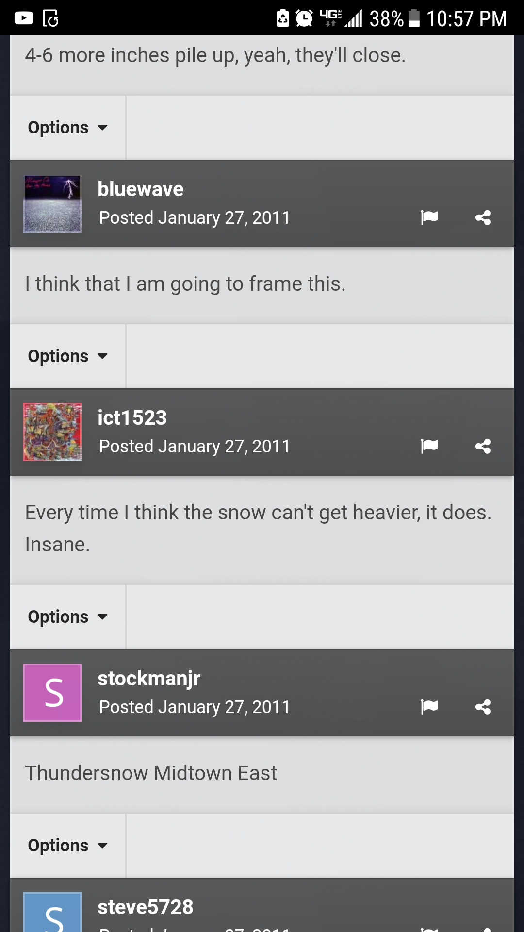
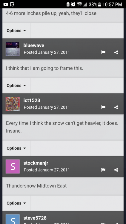
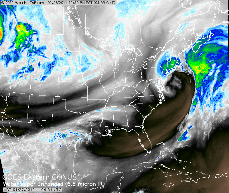
@bluewave loved it too. Too bad the image he posted is gone. (Most images from 7-8 years ago are gone)
-
My favorite CCB ever!!
-
Talk about past storms in here. Posts all your favorites and the ones you hated too. It might help keep the main disco threads from going too far off the rails. TIA.
-
Guess The Date Of The Next 12"+ Snowstorm In The OKX Zones
Rjay replied to bluewave's topic in New York City Metro
December 25th 2018 -
Hmm, what month is it?
-
How do we intelligently debate your word vomit? Read above
-
Vendor, Blog and TV Channel Forecasts Thread Part 2
Rjay replied to Rjay's topic in New York City Metro
So am I. I like short but nice 2 week winter period from late December through early January. Then a longer 5-6 week period from late January through early March. I also don't do seasonal forecast. We'll see. -
What Type Of Extreme Storm Will Make Headlines This October?
Rjay replied to bluewave's topic in New York City Metro
I think so too. But if you're referring to the Mexico Beach area, it's hard to tell what's storm surge damage vs wind damage. I guess the tree damage??? I saw fully debarked trees. -
Vendor, Blog and TV Channel Forecasts Thread Part 2
Rjay replied to Rjay's topic in New York City Metro
Most months have been in the top 10-15 warmest on record globally. You can't really blame them for betting on above average. -
Vendor, Blog and TV Channel Forecasts Thread Part 2
Rjay replied to Rjay's topic in New York City Metro
Disagree with first sentence. Good bet with the second sentence. -
Vendor, Blog and TV Channel Forecasts Thread Part 2
Rjay replied to Rjay's topic in New York City Metro
NOAA has been going warm for years iirc and JB is always cold and stormy. If I were a betting man I'd go with above average temps and above average snow. So "warm and stormy". -
What Type Of Extreme Storm Will Make Headlines This October?
Rjay replied to bluewave's topic in New York City Metro
Historic heat wave -
Tracking The 3”+ Heavy Rainfall Events Since 2010
Rjay replied to bluewave's topic in New York City Metro
Unfortunately no. I need to upgrade but have been saving for a new house. I think 5-10 mins would be a safe bet (maybe even less) but obviously we'll never know. This was Islip (13" deluge) level rainfall rates. -
Tracking The 3”+ Heavy Rainfall Events Since 2010
Rjay replied to bluewave's topic in New York City Metro
I got 4.62". I'm just happy someone else reported something near that to Upton bc the other totals aren't close. My buddy in Bellmore got 3.46".