nycsnow
-
Posts
4,105 -
Joined
-
Last visited
Content Type
Profiles
Blogs
Forums
American Weather
Media Demo
Store
Gallery
Everything posted by nycsnow
-
Discussion-OBS snow event sometime between 06z Thu 2/20-12z Fri 2/21?
nycsnow replied to wdrag's topic in New York City Metro
-
Discussion-OBS snow event sometime between 06z Thu 2/20-12z Fri 2/21?
nycsnow replied to wdrag's topic in New York City Metro
Even taking a step back cmc is still 8-12+ more east -
Discussion-OBS snow event sometime between 06z Thu 2/20-12z Fri 2/21?
nycsnow replied to wdrag's topic in New York City Metro
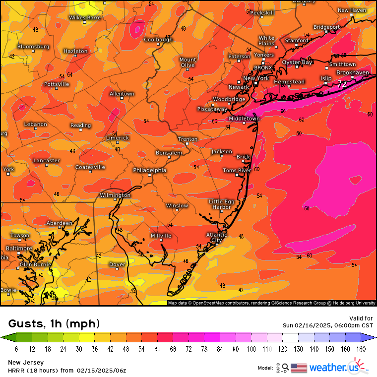
Verbatim icon has blizzard conditions for majority of us with wind gust 35-50 from 9am-6pm Thursday -
Discussion-OBS snow event sometime between 06z Thu 2/20-12z Fri 2/21?
nycsnow replied to wdrag's topic in New York City Metro
Entertainment only *** Image -
Discussion-OBS snow event sometime between 06z Thu 2/20-12z Fri 2/21?
nycsnow replied to wdrag's topic in New York City Metro
Image -
Discussion-OBS snow event sometime between 06z Thu 2/20-12z Fri 2/21?
nycsnow replied to wdrag's topic in New York City Metro
My god Image -
Discussion-OBS snow event sometime between 06z Thu 2/20-12z Fri 2/21?
nycsnow replied to wdrag's topic in New York City Metro
BOOM Image -
Discussion-OBS snow event sometime between 06z Thu 2/20-12z Fri 2/21?
nycsnow replied to wdrag's topic in New York City Metro
Icon should be better Image -
Discussion-OBS snow event sometime between 06z Thu 2/20-12z Fri 2/21?
nycsnow replied to wdrag's topic in New York City Metro
Was actually better than 0z def trended better -
Yea 6z hrr (to far out) but shows wind gust up to 70 off of Long Island with 60s hitting the coast. It’s gonna be a long duration event there’s gonna be some power problems
-
Models have been increasing the wind threat as well. Starting to see 60-65mph wind gust on short range models
-
Models increasing the wind threat. High wind watch up
-
Discussion-OBS snow event sometime between 06z Thu 2/20-12z Fri 2/21?
nycsnow replied to wdrag's topic in New York City Metro
Image -
Discussion-OBS snow event sometime between 06z Thu 2/20-12z Fri 2/21?
nycsnow replied to wdrag's topic in New York City Metro
Need it to head n/e now Image -
Discussion-OBS snow event sometime between 06z Thu 2/20-12z Fri 2/21?
nycsnow replied to wdrag's topic in New York City Metro
Image -
Discussion-OBS snow event sometime between 06z Thu 2/20-12z Fri 2/21?
nycsnow replied to wdrag's topic in New York City Metro
Incoming Image -
Discussion-OBS snow event sometime between 06z Thu 2/20-12z Fri 2/21?
nycsnow replied to wdrag's topic in New York City Metro
Eh Image -
Discussion-OBS snow event sometime between 06z Thu 2/20-12z Fri 2/21?
nycsnow replied to wdrag's topic in New York City Metro
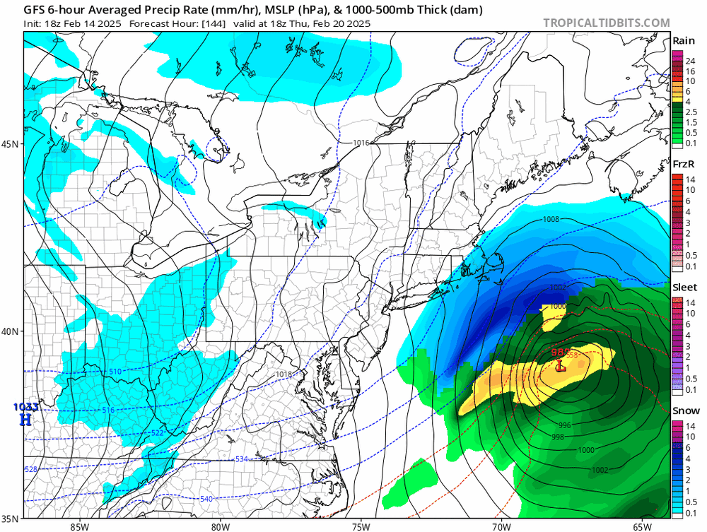
LONG TERM /SUNDAY NIGHT THROUGH FRIDAY/... Key Points: * Colder and windy conditions expected early next week after a cold frontal passage Sunday night. * Potential is increasing for a major winter storm from Wednesday night into Thursday night. Complex pattern developing over North America during this time should help lock in cold air, with one large closed low developing over eastern Canada and another in its wake over the northern Plains and upper Great Lakes. At the surface, strong low pressure moving from upstate New York toward the Canadian Maritimes Sunday night will bring a cold front through, with colder and brisk conditions for Monday and possibly into Tuesday via a tight pressure gradient between the low and strong high pressure off to the west. Meanwhile, shortwave energy moving onshore the West Coast early next week should dive toward the southern Plains by Wed AM and initiate sfc cyclogenesis along the northern Gulf coast daytime Wed. The degree to which this system phases with the northern Plains closed low will determine the track and intensity of the developing sfc low as it moves up the Southeast coast Wed night and then off the Mid Atlantic coast Thu/Thu night, pulling away on Fri. There is increasing potential for a major winter storm to impact the area from Wed night into Thu night with heavy snow during this time, also strong N winds Thu night--the 12Z ECMWF ensemble control run shows an intense low off the Mid Atlantic coast passing just outside the 40N/70W benchmark Thu night, bringing major snowfall for all the I- 95 cities from DC to Boston, with its axis of heaviest snowfall very close or just south and east which make sense given that storm track, while the ensemble control run shows widespread 50-60% potential for 6 or more inches of snow during this time. The Canadian model and its ensemble are in close agreement, while the deterministic GFS/ICON are suppressed, showing the heaviest snow mostly away from the big cities, impacting eastern Delmarva and southern NJ over to the Cape and Islands of MA. That said, the GEFS does show some ensemble members supporting the ECMWF/Canadian solution. Enough confidence in winter storm potential exists to include mention in the HWO. -
Discussion-OBS snow event sometime between 06z Thu 2/20-12z Fri 2/21?
nycsnow replied to wdrag's topic in New York City Metro
12z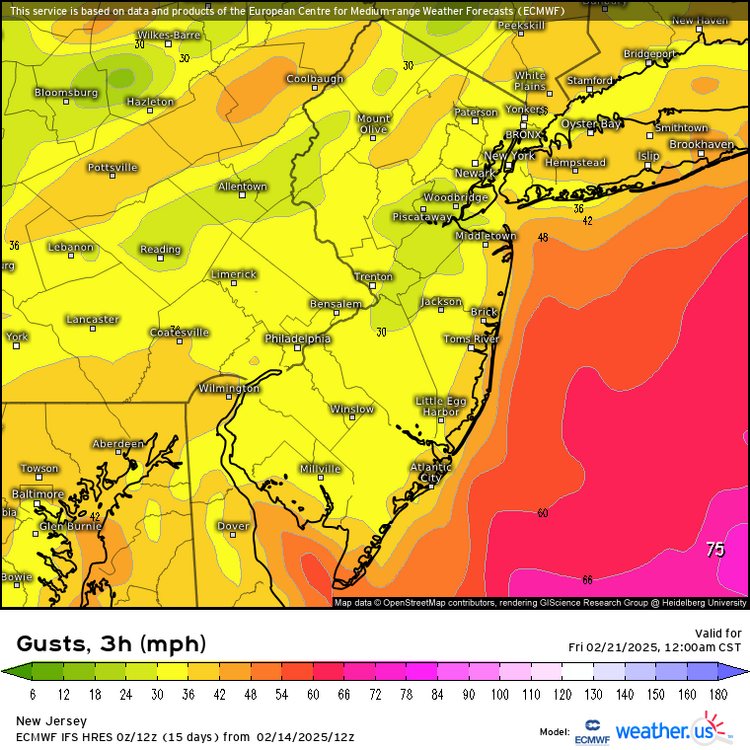
-
Discussion-OBS snow event sometime between 06z Thu 2/20-12z Fri 2/21?
nycsnow replied to wdrag's topic in New York City Metro
Mostly the coast this run, but if euro is right a 977 low offshore I’m pretty sure wind field would be larger but minor details at this point -
Discussion-OBS snow event sometime between 06z Thu 2/20-12z Fri 2/21?
nycsnow replied to wdrag's topic in New York City Metro
Euro would be a blizzard for coast with wind gust around 45mph -
Discussion-OBS snow event sometime between 06z Thu 2/20-12z Fri 2/21?
nycsnow replied to wdrag's topic in New York City Metro
Icon is a close miss Image