nycsnow
-
Posts
4,105 -
Joined
-
Last visited
Content Type
Profiles
Blogs
Forums
American Weather
Media Demo
Store
Gallery
Everything posted by nycsnow
-
Discussion-OBS snow event sometime between 06z Thu 2/20-12z Fri 2/21?
nycsnow replied to wdrag's topic in New York City Metro
This hurts https://x.com/nwsraleigh/status/1891253946418667941?s=46 -
Discussion-OBS snow event sometime between 06z Thu 2/20-12z Fri 2/21?
nycsnow replied to wdrag's topic in New York City Metro
Yea I’m giving it til 0z but this is done -
Discussion-OBS snow event sometime between 06z Thu 2/20-12z Fri 2/21?
nycsnow replied to wdrag's topic in New York City Metro
Euro is literally 0 for most of us -
Discussion-OBS snow event sometime between 06z Thu 2/20-12z Fri 2/21?
nycsnow replied to wdrag's topic in New York City Metro
18z euro?? Heard it’s wayyyyy ots -
Discussion-OBS snow event sometime between 06z Thu 2/20-12z Fri 2/21?
nycsnow replied to wdrag's topic in New York City Metro
Gfs brings a tropical storm up here in 9 days haha -
Discussion-OBS snow event sometime between 06z Thu 2/20-12z Fri 2/21?
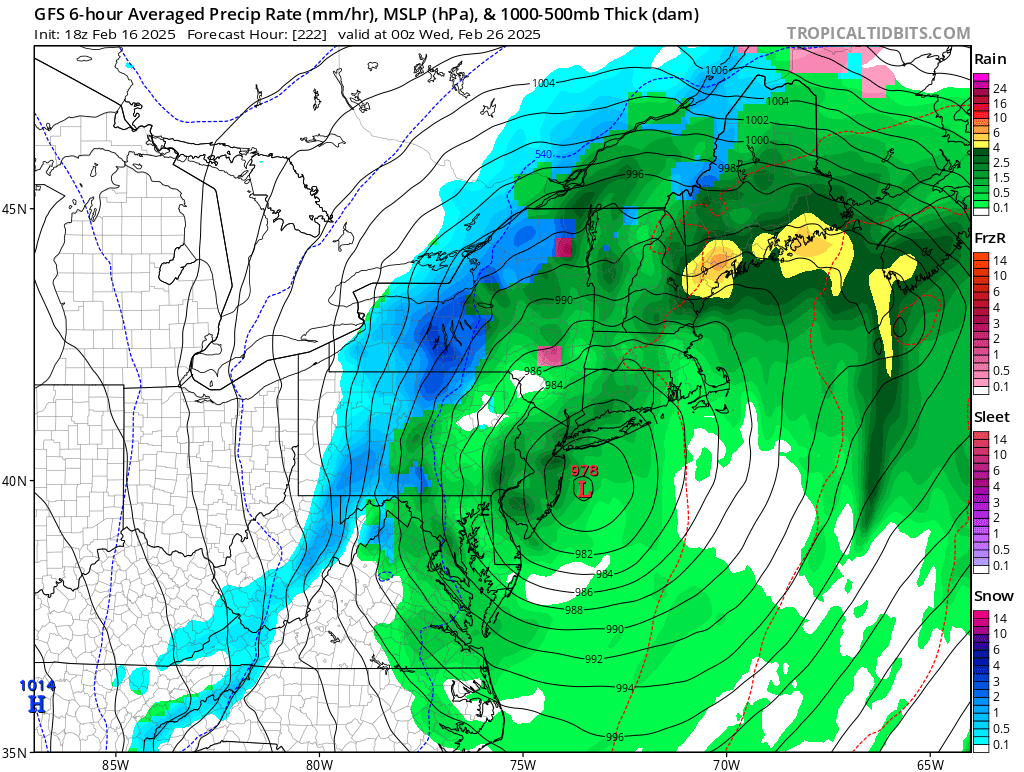
nycsnow replied to wdrag's topic in New York City Metro
Little bit n/w from 12z Image -
Discussion-OBS snow event sometime between 06z Thu 2/20-12z Fri 2/21?
nycsnow replied to wdrag's topic in New York City Metro
Extended Forecast Discussion NWS Weather Prediction Center College Park MD 153 PM EST Sun Feb 16 2025 Valid 12Z Wed Feb 19 2025 - 12Z Sun Feb 23 2025 ...Intense Arctic Blast for the Central to Eastern U.S. next week with an impactful South-Central U.S. to Mid-Atlantic Winter Storm... 19Z Update: The main feature of interest continues to be the developing low pressure system across the Southeast U.S. and then reaching the Mid-Atlantic Wednesday into early Thursday. Upon review of the 12Z model guidance suite, it is apparent that the surface low is trending a little more south as it exits the Outer Banks of NC and moving a little faster, taking more of a ENE track instead of a NE track up the coast. There has also been a slight trend in this direction as well with the ensemble low clusters over the past 24-48 hours of the ECENS/GEFS. This will have implications on the northern extent of the accumulating snows with this event, particularly across the northern Mid-Atlantic and southern New England. The latest 12Z model trends suggest less snow for those areas, and the axis of greatest snow across southern Virginia into the Delmarva, and the axis of any mixed precipitation farther to the south across North Carolina as well. It is important to note that these types of model trends can be temporary, and could possibly trend back to the north in future model runs and also once the higher resolution guidance begins to capture this event going into the short range forecast period. Otherwise the forecast elsewhere remains in good continuity with decent overall model agreement for most areas, with ensemble means increased to about 40% by next Sunday. The previous forecast discussion is appended below for reference. /Hamrick -------------------- -
Discussion-OBS snow event sometime between 06z Thu 2/20-12z Fri 2/21?
nycsnow replied to wdrag's topic in New York City Metro
Gfs looks like crap -
Discussion-OBS snow event sometime between 06z Thu 2/20-12z Fri 2/21?
nycsnow replied to wdrag's topic in New York City Metro
Gfs rolling let’s keep it going -
Discussion-OBS snow event sometime between 06z Thu 2/20-12z Fri 2/21?
nycsnow replied to wdrag's topic in New York City Metro
Big jump n/w on the ensembles 2 runs in a row -
Discussion-OBS snow event sometime between 06z Thu 2/20-12z Fri 2/21?
nycsnow replied to wdrag's topic in New York City Metro
Image -
Discussion-OBS snow event sometime between 06z Thu 2/20-12z Fri 2/21?
nycsnow replied to wdrag's topic in New York City Metro
Nice jump n/w Image -
Discussion-OBS snow event sometime between 06z Thu 2/20-12z Fri 2/21?
nycsnow replied to wdrag's topic in New York City Metro
Image -
Discussion-OBS snow event sometime between 06z Thu 2/20-12z Fri 2/21?
nycsnow replied to wdrag's topic in New York City Metro
Image -
Discussion-OBS snow event sometime between 06z Thu 2/20-12z Fri 2/21?
nycsnow replied to wdrag's topic in New York City Metro
Image -
Discussion-OBS snow event sometime between 06z Thu 2/20-12z Fri 2/21?
nycsnow replied to wdrag's topic in New York City Metro
Image -
Discussion-OBS snow event sometime between 06z Thu 2/20-12z Fri 2/21?
nycsnow replied to wdrag's topic in New York City Metro
Icon starting let’s see -
Discussion-OBS snow event sometime between 06z Thu 2/20-12z Fri 2/21?
nycsnow replied to wdrag's topic in New York City Metro
We’re back (sarcasm) Image -
Discussion-OBS snow event sometime between 06z Thu 2/20-12z Fri 2/21?
nycsnow replied to wdrag's topic in New York City Metro
He’s a clown, can very much be right but nothing is sampled lol it can be 0 or double digits -
Discussion-OBS snow event sometime between 06z Thu 2/20-12z Fri 2/21?
nycsnow replied to wdrag's topic in New York City Metro
Bernie rayno on twitter throwing out amounts trying to be the first to call it. Hope it blows up in his face -
Discussion-OBS snow event sometime between 06z Thu 2/20-12z Fri 2/21?
nycsnow replied to wdrag's topic in New York City Metro
Heard aifs went east as well??? -
Discussion-OBS snow event sometime between 06z Thu 2/20-12z Fri 2/21?
nycsnow replied to wdrag's topic in New York City Metro
Eh Image -
Discussion-OBS snow event sometime between 06z Thu 2/20-12z Fri 2/21?
nycsnow replied to wdrag's topic in New York City Metro
It’s over. Enjoy the long weekend, hopefully we start seeing models hop on some warmer weather. Only saving grace is we still have til Tom until it’s all sampled