Tuesday night, a wave of low pressure will pass well south of
Long Island, but bring some light snow accumulation the the
area. Our area is on the northern edge of the expected
precipitation shield, so southern locations are expected to
receive more snowfall. Latest forecast has trended in up in QPF
and snow amount for a few reasons. An upper level jet streak to
our north has slowly been trending farther north, which places
us under the right entrance region. Some guidance has also been
trending stronger in addition to the northward shift. Given the
support from the upper jet, the thinking is that QPF across much
of the guidance could be underdone. Did not make a major
change, but have up to 0.20 inches of QPF across the southern
half of the area. HREF QPF amounts look way underdone as the
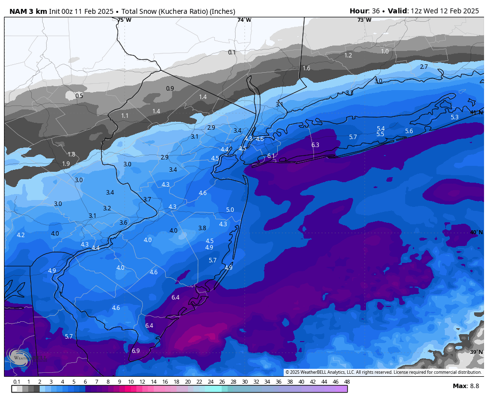
CAMs are likely struggling with the jet. The NAM is one of the
highest with 0.30 inches, which is not completely out of the
question, but before trending closer to those totals would like
to see a little more support from other guidance. It is worth
noting that the 18z NAM brings an enhanced area of 700mb
frontogenesis closer to our area than previous runs and other
guidance. This trend will need to be monitored because this
would support higher QPF as well. Also went with higher SLRs
than the previous forecast (around 13:1 average) which is
leading to 2 to 2.5 inches across NYC, Long Island and portions
of northeast NJ. Isolated 3 inch amounts are possible along the
immediate south coast. Farther north totals will be closer to .5
inches to 1 inch and northern interior CT and Lower Hudson
Valley likely see less than .5 inches.
Given the current totals, no headlines were issued. If QPF continues
to trend up it is possible that a Winter Weather Advisory would be
needed for Long Island, NYC and portions of northeast NJ