WxUSAF
-
Posts
26,452 -
Joined
-
Last visited
Content Type
Profiles
Blogs
Forums
American Weather
Media Demo
Store
Gallery
Everything posted by WxUSAF
-
16z hrrr not terrible by todays standards
-
Almost 0.2” of welcome rain overnight.
-
12z about equally huggable.
- 1,696 replies
-
- 3
-

-
- severe
- thunderstorms
- (and 5 more)
-
SLGT risk extended for far N/W burbs tomorrow.
-
Hugging 6z 3k NAM
- 1,696 replies
-
- 1
-
-
- severe
- thunderstorms
- (and 5 more)
-
Subtle differences in the ridge axis next week might be the difference between daily afternoon scattered storms and just hot, muggy, and dry.
-
The tornado day last week was exceptional for a lot of reasons obviously, but it seems like we are in a multi-year drought for thunderstorm frequency alone. Not even counting severe storms.
- 1,696 replies
-
- 6
-
-
- severe
- thunderstorms
- (and 5 more)
-
Low of 52.5. Mid September before it gets this cool again?
-
Definite big heat potential next week. Luckily I’ll be in Hilton head with some sea breeze relief!
-
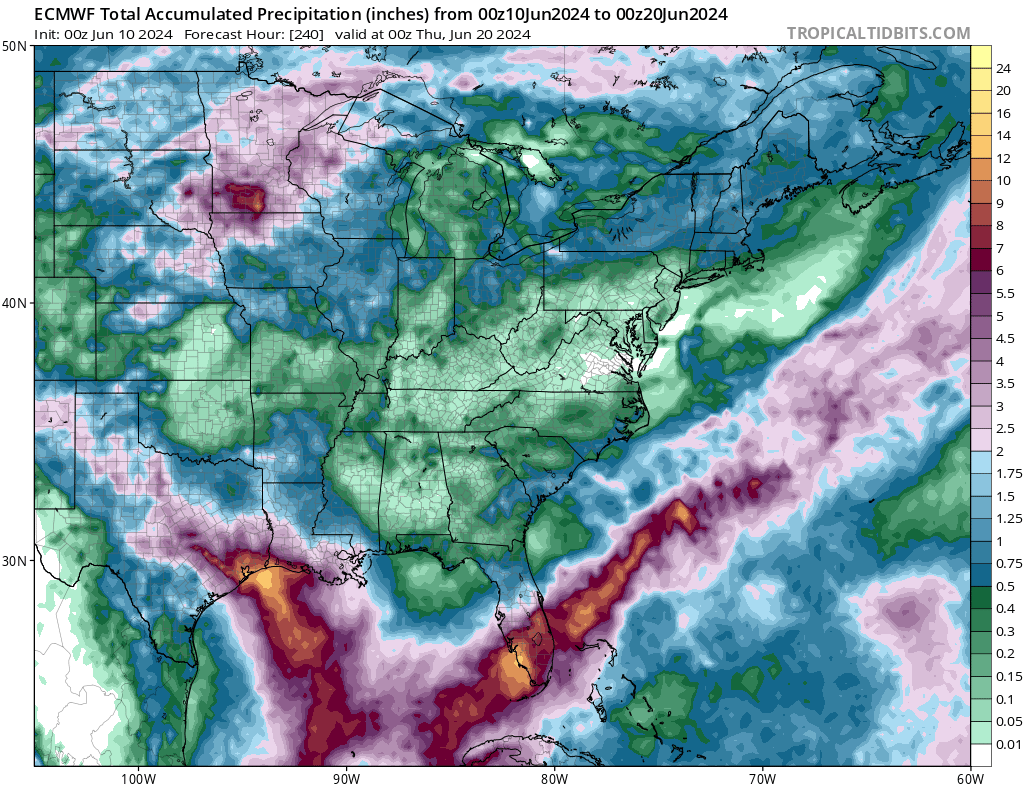
12z euro most robust I’ve seen yet, at least from a rain POV.
-
Any chance the Friday FROPA gets a little more interesting? Big heat with a cold front on the same today suggests interest to me, but guidance is pretty dry.
-
Gorgeous windows open sleeping weather these last several days. Except for the catbird that starts squawking at 4am….
-
Here we go
-
We don’t get summer days much nicer than this…
-
Tornado confirmed very near me in Columbia yesterday.
- 1,696 replies
-
- 4
-
-
- severe
- thunderstorms
- (and 5 more)
-
weather.cod.edu/satrad
-
- 1,696 replies
-
- 5
-

-
-
- severe
- thunderstorms
- (and 5 more)
-
Tamar and High Tor Hill is VERY close to me
- 1,696 replies
-
- 1
-
-
- severe
- thunderstorms
- (and 5 more)
-
Dang…this storm over Baltimore is a long track supercell. Probably 40-50 miles and counting? We don’t get a lot of those.
- 1,696 replies
-
- 1
-
-
- severe
- thunderstorms
- (and 5 more)
-
-
I’m in southeast Columbia. That couplet is going very close to downtown. >5”/hour rain rate with this storm
- 1,696 replies
-
- 2
-
-
- severe
- thunderstorms
- (and 5 more)
-
Velocity couplet looks legit south of the Columbia mall
-
We’re in our basement
- 1,696 replies
-
- 3
-

-
-
- severe
- thunderstorms
- (and 5 more)
-
I’m about to get something in Columbia
- 1,696 replies
-
- 2
-
-
- severe
- thunderstorms
- (and 5 more)