WxUSAF
-
Posts
28,769 -
Joined
-
Last visited
Content Type
Profiles
Blogs
Forums
American Weather
Media Demo
Store
Gallery
Everything posted by WxUSAF
-
I think buses are already rolling. Need some rates…my snow is subliming before 2 snowflakes can pile on top of each other.
-
Few flakes flying in Columbia. Kids are going to be disappointed in a full day of school!
-
You had a small typo there on I70 and accidentally typed “Rt50”
-
Yeah this will accumulate efficiently on roads, especially side roads.
-
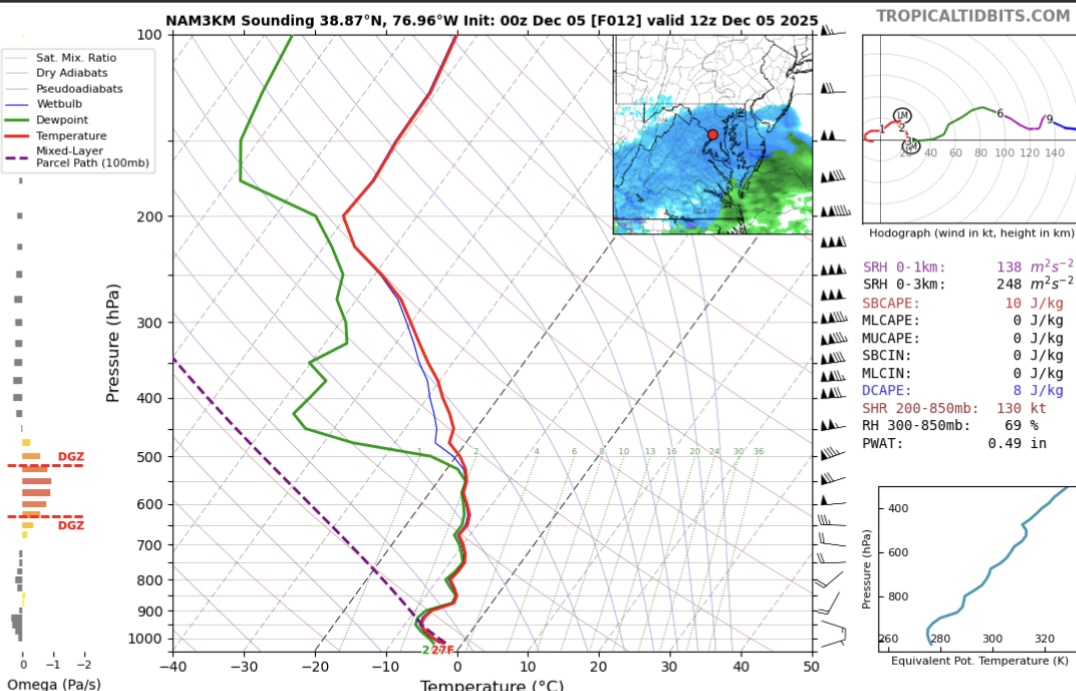
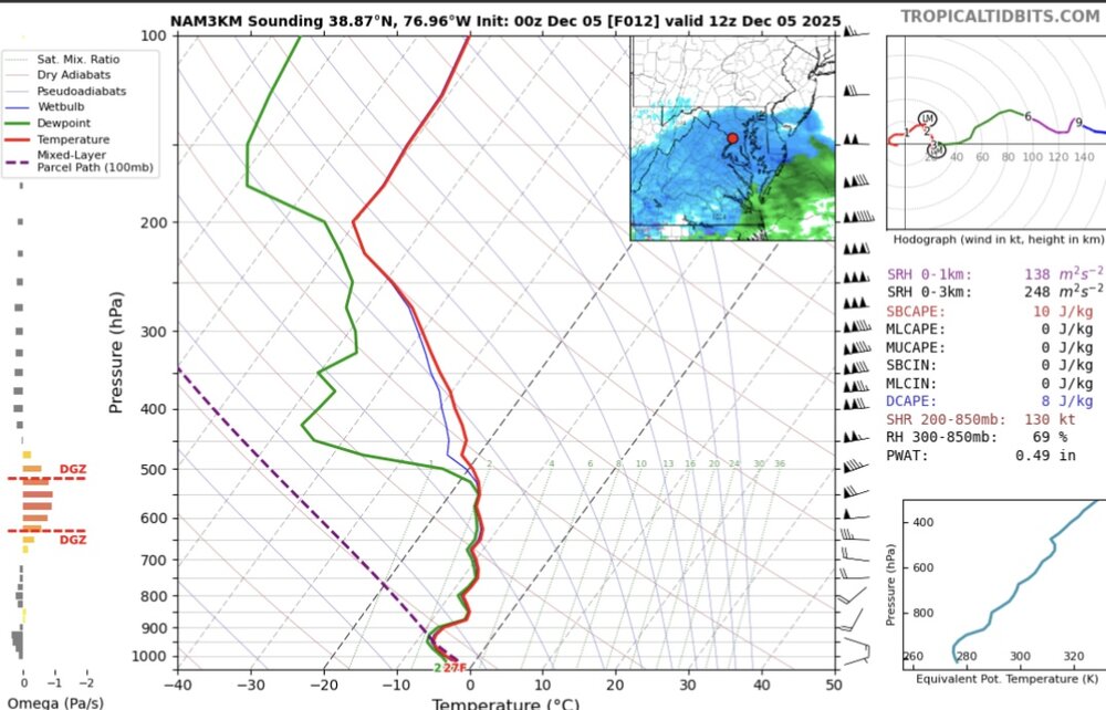
@SnowenOutThere 0z nam 3k soundings look much better for dendrite production. I just looked at DC, but a nice wide DGZ with moderate lift for several hours tomorrow morning. This is 12z for DC.
-
CWG upped forecast to 1-2” for I66/Rt50 corridor and DC
-
29/20. Calling 0.6” for MBY. Hoping for over 1”.
-
In all seriousness, snow ratios are very difficult to predict with the kind of accuracy we want. Your point about lift being displaced from the DGZ is a good one and probably worth not getting too hopeful of >10:1. But even if we don’t have beautiful dendrites, we should have plates and those are usually 10:1 or so. Needles are the danger zone…those accumulate like sand. Often 5-6:1.
-
We’re getting 20:1 in Columbia, not sure for you
-
For any psychopaths awake at 2-5am, don’t freak out by the “donut hole” look on LWX radar. That will be due to dry air subliming our snow as @SnowenOutThere posted about. It does not mean models are over predicting precipitation, etc.
-
Super active =\ super wet
-
Oh look, another attempt at a warm up (after next weekend) that looks muted all of a sudden... Op runs are super active, if northern stream dominated (as expected).
-
Should be posting 20:1 maps with these conditions! Where's @paulythegun?
-
Gfs is north and juicy. Pummels @Bob Chill to RIC.
-
12z FV3 way north of its 0z. Flurries to I70.
-
Looking ahead because I’m pissed I’m getting screwed tomorrow. Late next week definitely has some things going for it with a -NAO and 50/50 combo. Also a flat ish +PNA. If we can get that PNA to spike and get the shortwave coming out of the northern stream to dive below us, we could get something going. 0z euro and 6z gfs both develop a weak coastal storm in this window but move it away from us really quick.

-
Damn. Not what I wanted to wake up to.
-
3k was still a huge jump north and expansion of the precip field
-
Models fully account for precip evaporating or subliming during descent.
-
Let’s pull off a 1/30/10
-
Seems like with the 18z runs we finally have some consensus, it’s just consensus on dusting-1” for the majority of us instead of the 1-3” we were hoping for. That shortwave is trending stronger so maybe we can juice this up some more. Or rely on 20:1 ratios??
-
-
18z rgem was also north. It more clearly is loosening the confluence vs recent runs. Can we sustain some positive trends for more than 1 cycle now?
-
And much juicier down south. @Bob Chillgonna need to put the plow on his tractor.
-
Click through the previous 5-6 GFS runs and you can see our shortwave gets much sharper and better defined. Confluence is bouncing around more, which isn’t surprising from a more poorly sampled region.