

WxUSAF
-
Posts
26,440 -
Joined
-
Last visited
Content Type
Profiles
Blogs
Forums
American Weather
Media Demo
Store
Gallery
Everything posted by WxUSAF
-
Showers seem incapable of crossing the fall line lol
-
Heavy precip meso issued for most of the area
-
East side is definitely more variable. But 3k NAM is not a tropical model…
-
@midatlanticweather does WPC break it down by day? Euro has been very bullish on rain late today through tomorrow, and that’s a significant fraction of total rain for those of us east of the mountains. Curious what WPC thinks of that. @MillvilleWx?
-
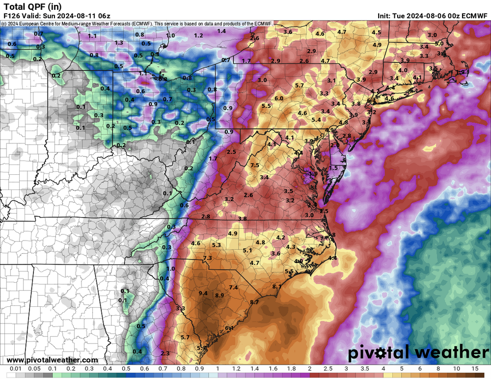
0z euro remains a deluge for all
-
Wow, storms evaporated on my doorstep last night. 0.01” lol
-
That line of storms between the other two area of storms ripped open like a zipper in minutes. Very cool radar presentation. Think DC-north gets some nocturnal action (hi RR).
-
Euro is generally 3-6”, but a few bust/boom spots here and there. Ride up the Apps so it’s a deluge for Shenandoah valley and Blue Ridge.
-
And for a lot of us, the rain’s spread out from this evening through late Friday. So that would reduce flooding risks and help it soak in. Euro really emphasizes the rain tomorrow and Thursday with onshore flow focused along the front through our area.
-
Gfs slowly coming in line with other guidance
-
-
0z euro washes Stephen’s City away.
-
Happy hour gfs still with the big left turn
-
Euro takes what’s left of Debby over Annapolis as a 999mb low early Saturday.
-
Depending on the track, I could envision how the metro area is a relative minimum with upslope enhancement in the mountains and more precipitation with the storm center to the southeast.
-
GFS pushes the front through tomorrow and Wednesday. Also gives us decent rain/storms with the front. This makes Debby wander back west instead of more due north like other guidance. The other guidance doesn’t push the front through anymore, and Debby’s able to track north.
-
5-10” possible with good ratios??
- 755 replies
-
- 21
-

-

-
6z WPC map is 3-6” for the entire subforum
-
Even gfs pulls a lot of moisture up the front though.
-
Nearly 1” of rain in a short time from that tiny storm! Juicy airmass!
-
12z WPC update still favors a very rainy week
-
And that is what happens in the majority of guidance. Euro most consistent, but even the 6z gfs goofy track depiction pulls the moisture up along the boundary next weekend.
-
Almost 0.5”. 2” since Monday.
-
My neighbors PWS around 0.2”, but it did come quick. Round 2 looks good for now. Rain on back to back days!? That’s allowed?


