WxUSAF
-
Posts
28,777 -
Joined
-
Last visited
Content Type
Profiles
Blogs
Forums
American Weather
Media Demo
Store
Gallery
Everything posted by WxUSAF
-
Euro AI is consistent with the idea of coastal development on Sunday. Definitely the solution PHL-BOS is rooting for. Don’t know how much snow for our area. Probably 1-3”ish?
-
0z and 6z euro looked a lot like gfs and ukie?
-
Nice right entrance region of the jet max over us also around 6-12z on the gfs.
-
Something like that is showing up in the euro too. Tiny coastal enhancement? Need a 20-30mi north shift though.
-
Yeah, I think that was the coldest Xmas of the 20 year period and it was the worst snowfall year ever for MBY.
-

12/12: The little Friday clipper that could? Or won't.
WxUSAF replied to dailylurker's topic in Mid Atlantic
Gonna ignore the white dot over my house -
Uh, well it Fs us both pretty badly, but other people cash in
-
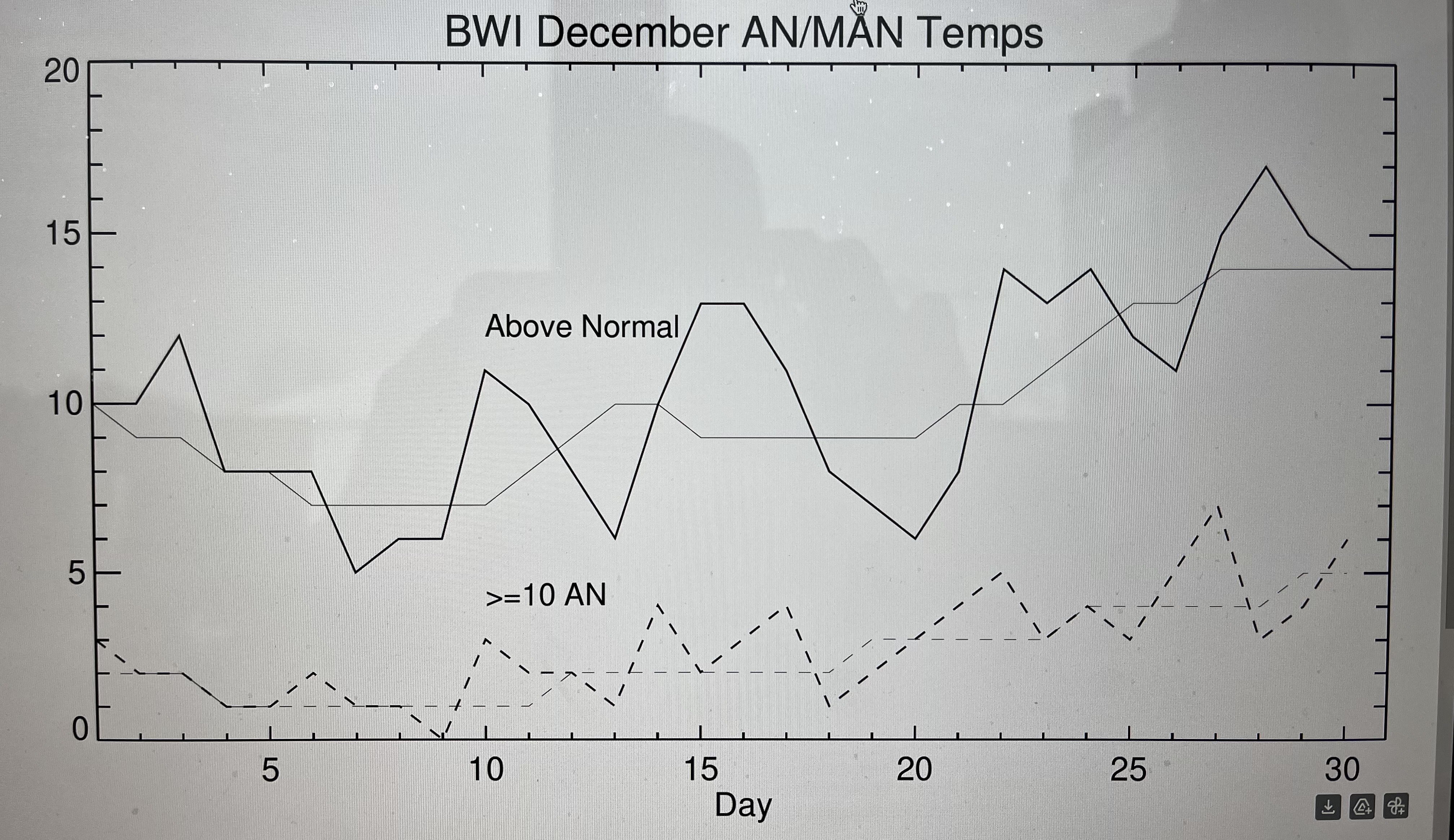
With potentially another Xmas torch staring us in the face, I decided to make a plot to see if it’s been as real as it feels or has been for years. So this plot is BWI above normal and much above normal (>=10F) occurrences from 2005-2024. Thicker lines are the year by year counts for each calendar day and thin lines are smoothed by 7 days. Short answer is yes…and the week after Xmas before new years has been the most torch prone.
-
The warm pool moving eastward would be a good thing for us. Basically puts the background conditions to support the strongest convection (essentially the MJO) in a more favorable position for eastern troughing.
- 827 replies
-
- 13
-

-

-
Last Friday's storm almost disappeared for DC-north within 36 hours? So I don't expect much consistency on a weak vort in fast flow until like 0z Thursday.
-
Just seems weak based on precip. Doesn’t give anybody a ton of love.
-
EPS likes Friday more than Sunday.
-
Euro AI is nothing for Friday outside the mountains. Sunday leans north of us, but dusting for DC, 1” for Baltimore, near 2” along M/D line
-
There it is on 12z gfs. Which is more inevitable? Thanos or Torchmas?
-
GGEM follows icon and Fs us twice
-
Gfs Friday clipper looks great and then falls the F apart, but not before giving VA some much deserved snow!
-
-
Sort of similar to GEPS, but better over the pole. That’s a gradient look, but obviously a lot of cold air available to tap. Not shut the blinds.
-
And 6z GEFS completely flips to se ridge
-
The torch/SE ridge progs have stayed firmly beyond D10 for weeks now. Maybe this one is different but I want to see it inside of D7 first before I buy it. Persistent MJO phase 8 argue against it.
-
12-14 as the low depending on which PWS I look at.
-
Would it even be the Christmas season without some days in the 60s!?!
-
Big divergence in ensembles toward Xmas. GEFS keeps an eastern trough although the western ridge pushes the trough axis over us and even offshore for a time. EPS goes full SE ridge with a deep western trough developing. Geps somewhat in between but leaning more toward EPS.
-
-
There were some changes at 500 that I liked actually. Looked like it almost phased in some more energy up in Canada. I think it was pretty close to a bigger event.