WxUSAF
-
Posts
28,769 -
Joined
-
Last visited
Content Type
Profiles
Blogs
Forums
American Weather
Media Demo
Store
Gallery
Everything posted by WxUSAF
-
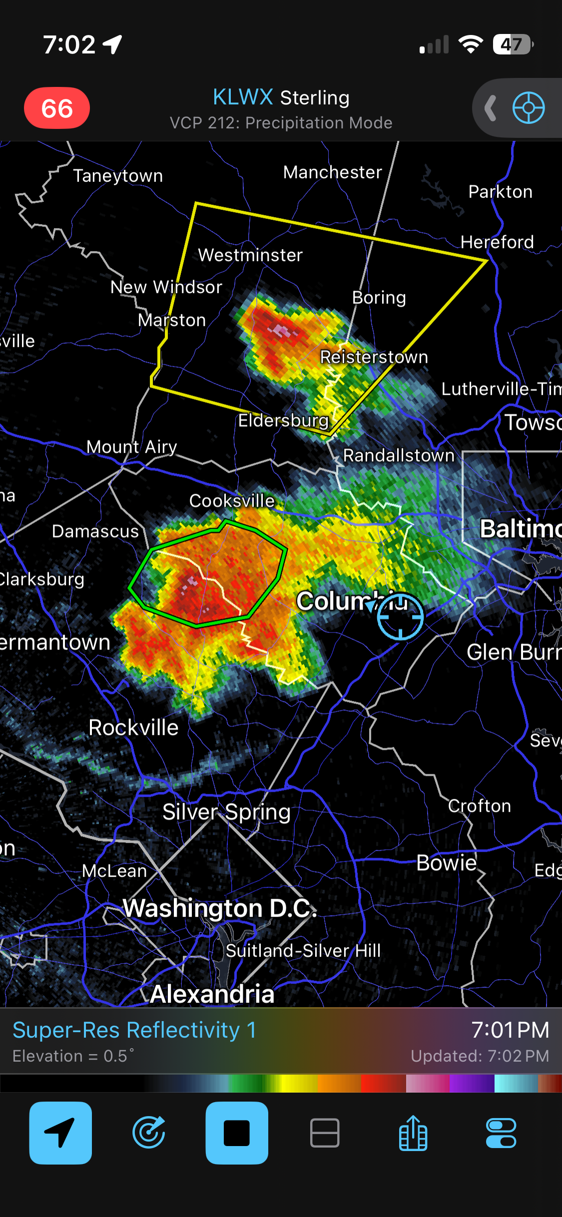
495 has been the screw zone so far the last 2 days. Hopefully you all cash in today and tomorrow. That line almost missed me last evening but it extended down just briefly, and damn was that rain intense.
-
Looks like it will, but we'll see when it enters the metro area where all those outflow boundaries have gone every which way
-
That big northern AA cell is still building south. Not sure exactly where you are, but think you're close...
-
About 0.7”. Been thundering almost constantly for nearly 3 hours
-
Two big outflows about to collide near the Potomac north of DC
-
Still very unlucky for MBy rainfall lol
-
If that was happening over downtown Ellicott city it would be testing the new flood mitigation
-
STW posted
-
Severe Storm Watch now issued for most of LWX
-
Constant thunder
-
WPC meso posted for entire LWX zone for flash flood potential
-
Clouds and thunder from that big cell on the HoCo-MoCo line, but it’s building the wrong way eta…same area in HoCo that got the good last evening going to win again
-
19z hrrr more like NAM in that regard. Very nice everyone wins scenario
-
My yard is looking like Texas hardpan so the runoff would be high in any quick downpour
-
18z hrrr most encouraging run of the day for metro area rainfall
-
I’ve seen lots of pinks and purples on QPF maps for awhile and the ground truth has been lacking
-
12z guidance suggests today we’re too far south and tomorrow too far north.
-
Going to be 0.1” or just over in Columbia. Maybe just a T for Greenbelt.. crazy I95 rain shield
-
I95 split for the ages so far. Hopefully it fills in
-
Just had lightning and thunder in Greenbelt
-
That specific cell will miss MBY northwest @yoda but stuff is popping so we’ll see
-
Storm just popped behind the bay breeze front in northern AA county
-
Going to develop overhead? Radar looks like shit for us
-
Shitty metro area fail? Or will that EZF cluster push north?
-
Hrrr seems to have the evolution down , but coverage looks higher than it shows