WxUSAF
-
Posts
26,466 -
Joined
-
Last visited
Content Type
Profiles
Blogs
Forums
American Weather
Media Demo
Store
Gallery
Everything posted by WxUSAF
-

Late January and February Medium/Long Range Discussion
WxUSAF replied to WinterWxLuvr's topic in Mid Atlantic
Good short thread here- 4,130 replies
-
- 2
-

-
- prime climo
- cold canada
- (and 1 more)
-
Late January and February Medium/Long Range Discussion
WxUSAF replied to WinterWxLuvr's topic in Mid Atlantic
@Bob Chill and I have similar thoughts regarding this threat. I think hoping for a 1-3”/2-4” event as the northern trough swings through might be better odds. GFS has shown that off and on and now GGEM sort of does.- 4,130 replies
-
- 2
-
-
- prime climo
- cold canada
- (and 1 more)
-
Late January and February Medium/Long Range Discussion
WxUSAF replied to WinterWxLuvr's topic in Mid Atlantic
IF (MA_weenie_prayers)=.true. THEN PRINT, “Gott ist tot” ENDIF- 4,130 replies
-
- 3
-

-
- prime climo
- cold canada
- (and 1 more)
-
Late January and February Medium/Long Range Discussion
WxUSAF replied to WinterWxLuvr's topic in Mid Atlantic
Thanks. Neutral AO is certainly better than ++AO. PNA and AO are the 2 indices best correlated to DCA snowstorms. Having one or the either in a great position is a major help, especially if the other isn’t explicitly hostile.- 4,130 replies
-
- 1
-
-
- prime climo
- cold canada
- (and 1 more)
-
Late January and February Medium/Long Range Discussion
WxUSAF replied to WinterWxLuvr's topic in Mid Atlantic
I think @high riskhas said what’s going to happen eventually is the new mesoscale model that will replace the NAM will be run hourly. Going to be fun!- 4,130 replies
-
- 2
-
-

-
- prime climo
- cold canada
- (and 1 more)
-
Late January and February Medium/Long Range Discussion
WxUSAF replied to WinterWxLuvr's topic in Mid Atlantic
This is a huge wag, but I think 8”+ could be possible given how perfect that PNA ridge placement seems to be. But as you know, the lack of Atlantic side help makes the window very very small. I like overrunning events so much more because there’s much more wiggle room.- 4,130 replies
-
- 5
-
-
- prime climo
- cold canada
- (and 1 more)
-
Late January and February Medium/Long Range Discussion
WxUSAF replied to WinterWxLuvr's topic in Mid Atlantic
Ding ding ding NAO isn’t as critical. (Virtually) No way DC is getting 18” with a +AO. But that PNA is basically ideal, so a better than normal event is possible on that basis alone.- 4,130 replies
-
- 5
-
-
-
- prime climo
- cold canada
- (and 1 more)
-
Late January and February Medium/Long Range Discussion
WxUSAF replied to WinterWxLuvr's topic in Mid Atlantic
Ugh, hate that gap in the 30”+ amounts over my house. Hope I can get a favorable trend soon.- 4,130 replies
-
- 13
-
-

-
-
- prime climo
- cold canada
- (and 1 more)
-
Late January and February Medium/Long Range Discussion
WxUSAF replied to WinterWxLuvr's topic in Mid Atlantic
Love you all doing weekend HH GFS pbp for a D7 storm.- 4,130 replies
-
- 12
-
-
-
- prime climo
- cold canada
- (and 1 more)
-
Late January and February Medium/Long Range Discussion
WxUSAF replied to WinterWxLuvr's topic in Mid Atlantic
A mostly zonal pattern across the CONUS with cold air north of the boundary and warm air south. It’s a classic pattern for overrunning events.- 4,130 replies
-
- 2
-
-
- prime climo
- cold canada
- (and 1 more)
-
Late January and February Medium/Long Range Discussion
WxUSAF replied to WinterWxLuvr's topic in Mid Atlantic
Yup. A straight up Miller B scenario is destined to fail when the Atlantic side looks like it does in this scenario. Got to have the southern stream involved, but also don’t want a cutoff southern low. This thing is going to be complicated and complicated rarely works for us, especially in a Niña.- 4,130 replies
-
- 2
-
-
-
- prime climo
- cold canada
- (and 1 more)
-
Low of 12.4. Second coldest morning this winter. If only we had a little snowcover…would have been easy single digits.
-
Congrats all. My sister lives in Cary, NC, and reports “about 3 inches”. She and my nieces are very excited!
-
It’s up to you all, but we have a pinned thread for this storm. You’re welcome and encouraged to use it!
-
Late January and February Medium/Long Range Discussion
WxUSAF replied to WinterWxLuvr's topic in Mid Atlantic
I NEED my fix of blue pixels man!- 4,130 replies
-
- 5
-
-
-
- prime climo
- cold canada
- (and 1 more)
-
Euro has a little too now
-
Late January and February Medium/Long Range Discussion
WxUSAF replied to WinterWxLuvr's topic in Mid Atlantic
lol and I thought the GFS solution was goofy- 4,130 replies
-
- 1
-
-
- prime climo
- cold canada
- (and 1 more)
-
Late January and February Medium/Long Range Discussion
WxUSAF replied to WinterWxLuvr's topic in Mid Atlantic
Damn...for at least the 140-162hr period, the Euro evolution is way more classic, simple, and pretty than the convoluted hot messes that the GFS and GGEM show.- 4,130 replies
-
- 3
-
-
- prime climo
- cold canada
- (and 1 more)
-
Late January and February Medium/Long Range Discussion
WxUSAF replied to WinterWxLuvr's topic in Mid Atlantic
The northern stream wave that the GFS phases into the monster just scoots through the Lakes quickly on the GGEM. But then this beastly closed 500mb low appears out of nowhere and partially phases. Both look like very simple and clean solutions, so obviously a lot of model consistency coming up!- 4,130 replies
-
- 4
-
-
-
- prime climo
- cold canada
- (and 1 more)
-
Late January and February Medium/Long Range Discussion
WxUSAF replied to WinterWxLuvr's topic in Mid Atlantic
Oh man, GGEM does it too. SE weenies climaxing.- 4,130 replies
-
- 10
-
-
- prime climo
- cold canada
- (and 1 more)
-
Late January and February Medium/Long Range Discussion
WxUSAF replied to WinterWxLuvr's topic in Mid Atlantic
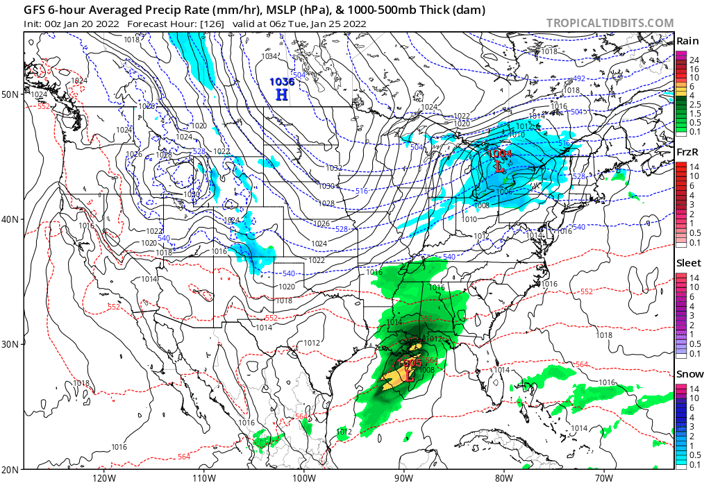
GGEM and GFS both working slowly in the right direction for Tuesday next week with more spacing between the northern and southern waves. Need that to continue so the northern stream can drag the cold air in enough. GGEM today is very close to that and has a strong enough southern wave to flip us to 1-3" of snow after some rain by dragging in some colder air.
- 4,130 replies
-
- 6
-
-
- prime climo
- cold canada
- (and 1 more)
-
Late January and February Medium/Long Range Discussion
WxUSAF replied to WinterWxLuvr's topic in Mid Atlantic
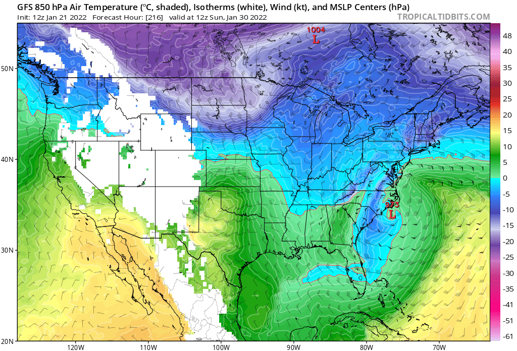
Just your standard mid-latitude cyclone with a cold conveyor belt extending down to the Bahamas.
- 4,130 replies
-
- 9
-
-
-
- prime climo
- cold canada
- (and 1 more)
-
Late January and February Medium/Long Range Discussion
WxUSAF replied to WinterWxLuvr's topic in Mid Atlantic
At hour 150 I hit the “Prev. Run” and “Next Run” buttons on TT like 6 times because I thought I was looking at the wrong thing. To be generous, 6z looks like it got bad chili. 12z isn’t THAT different from earlier runs at that point.- 4,130 replies
-
- 1
-
-
- prime climo
- cold canada
- (and 1 more)
-
Thanks for the feedback!
-
Late January and February Medium/Long Range Discussion
WxUSAF replied to WinterWxLuvr's topic in Mid Atlantic
Updated thread title because I’m still planning for 10” more of January snow- 4,130 replies
-
- 8
-
-
-
- prime climo
- cold canada
- (and 1 more)