-
Posts
28,483 -
Joined
-
Last visited
Content Type
Profiles
Blogs
Forums
American Weather
Media Demo
Store
Gallery
Everything posted by WxUSAF
-
DCA might be relying on an intrahour...
-
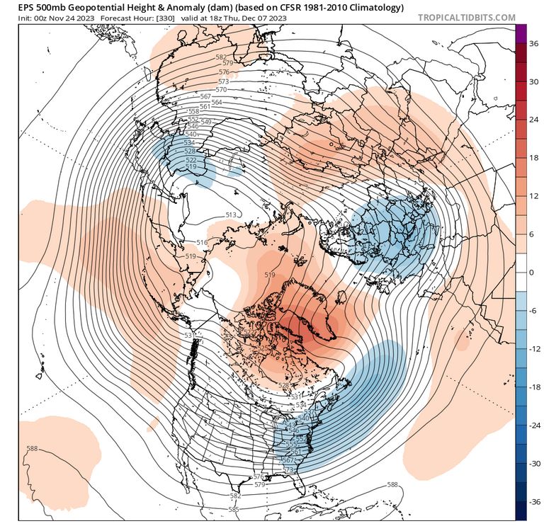
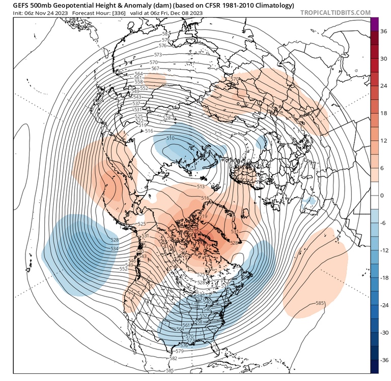
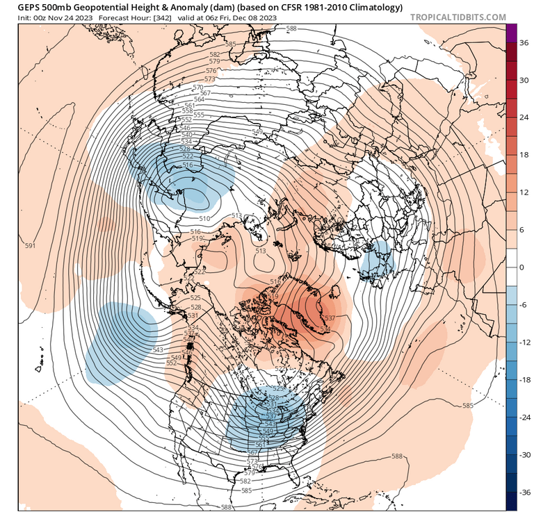
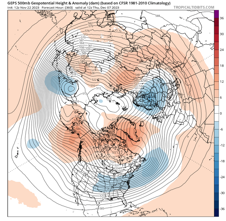
I agree. As currently depicted, it's a "real" -NAO. I think he's splitting hairs that it's not forming through the one way of a Scandinavian ridge that retrogrades into the NAO domain. But Rossby wave breaking is also a very "real" way for a -NAO to form, and that's what's happening here. One thing I'm watching for is the orientation of the ridge. I want to see it develop that E-W orientation that's being advertised, and not just N-S. An E-W ridge over Greenland and Baffin is FAR more effective than a poleward oriented ridge over Greenland or Iceland.
- 1,295 replies
-
- 3
-

-
- wishcasting
- almost winter
-
(and 1 more)
Tagged with:
-
Webb is very rapidly flipping to JB level bullish on this winter lol
- 1,295 replies
-
- 1
-

-
- wishcasting
- almost winter
-
(and 1 more)
Tagged with:
-
Skepticism isn’t a bad plan given recent years. But we do have a good pattern starting basically today through next weekend. Just doesn’t look like it will do much for us except BN temps. This new -NAO dominated pattern after the 7th is still a recent arrival on guidance so caution is warranted. GEFS actually brings it in faster today on the 12z run. So far the opposite of cankicking.
- 1,295 replies
-
- 11
-

-

-
- wishcasting
- almost winter
-
(and 1 more)
Tagged with:
-
- 1,295 replies
-
- 14
-

-

-
- wishcasting
- almost winter
-
(and 1 more)
Tagged with:
-
-NAO come at ya fast
- 1,295 replies
-
- 4
-

-
- wishcasting
- almost winter
-
(and 1 more)
Tagged with:
-
Bingo
- 1,295 replies
-
- 5
-

-

-

-
- wishcasting
- almost winter
-
(and 1 more)
Tagged with:
-
Euro has a pretty good setup at D10. Looks like a setup for a snow to rain type deal. Euro control run may show something. Although it’s obvious next week’s cold won’t stick around to March, doesn’t look like we flip to a shit the blinds kinda pattern. So that’s good. Keep December 2015 outta here.
- 1,295 replies
-
- 10
-

-
- wishcasting
- almost winter
-
(and 1 more)
Tagged with:
-
I want a lot of events as well, but this is a sacrifice I’m willing for you to make.
- 1,295 replies
-
- 17
-

-

-
- wishcasting
- almost winter
-
(and 1 more)
Tagged with:
-
Happy thanksgiving!
-
BWI: 22.6” DCA: 17.4” IAD: 25.1” RIC: 12.5” SBY: 11.9”
-
You’re not wrong. Most of this discussion is following from one of Webb’s tweets today discussing that -NAO Decembers in Ninos usually suggest persistent -NAO for the whole winter. Even though the EPS plot @CAPE showed above is improved from 0z, it’s not a cold/snow pattern because of that strong -PNA.
- 1,295 replies
-
- wishcasting
- almost winter
-
(and 1 more)
Tagged with:
-
- 1,295 replies
-
- 7
-

-

-
- wishcasting
- almost winter
-
(and 1 more)
Tagged with:
-
Very doubtful, not that JB would ever admit that.
- 1,295 replies
-
- wishcasting
- almost winter
-
(and 1 more)
Tagged with:
-
Don’t need a SSW for major cold and snow. A weak, wobbly strat vortex is just fine.
- 1,295 replies
-
- 10
-

-

-
- wishcasting
- almost winter
-
(and 1 more)
Tagged with:
-

2023 Mid-Atlantic Garden, Lawn, and Other Green Stuff Thread
WxUSAF replied to mattie g's topic in Mid Atlantic
Same. Chop up leaves and mow it short to make our 1 slushy dusting in late January more picturesque! -
Next week looking quite cold but dry. Fate of the winter hangs in the balance of getting a small accumulation over 1 acre of our subforum.
- 1,295 replies
-
- 20
-

-

-

-
- wishcasting
- almost winter
-
(and 1 more)
Tagged with:
-
I’m declaring a SEVERE LEAF DROP WARNING for the entire region for the next 48 hours.
- 727 replies
-
- 10
-

-

-

-
Not yet. Still things in November we’re watching.
- 1,295 replies
-
- 3
-

-
- wishcasting
- almost winter
-
(and 1 more)
Tagged with:
-
@snowman19 again, that pattern Roundy shows is quite different than anything Webb is suggesting.
-
Oh I’m sure. Just was laughing to myself with Webb thinking Roundy’s post validated his super-Nino east CONUS December torch prediction when it looks quite the opposite.
-
I know Webb didn’t, but did you bother to click on Roundy’s link and see that the pattern he’s showing looks very NON-torchy for the east CONUS??
-
GGEM and Euro both have a pretty tasty setup around Saturday/Sunday. Neither really come together, but the players are there with a transient 50/50, fresh high coming in on top of low forming in the Plains and riding the thermal boundary eastward. Both models have another northern stream shortwave come in and mix everything up.
- 1,295 replies
-
- 6
-

-
- wishcasting
- almost winter
-
(and 1 more)
Tagged with:


