-
Posts
26,454 -
Joined
-
Last visited
Content Type
Profiles
Blogs
Forums
American Weather
Media Demo
Store
Gallery
Everything posted by WxUSAF
-
maybe time to step away from the computer for awhile?
-
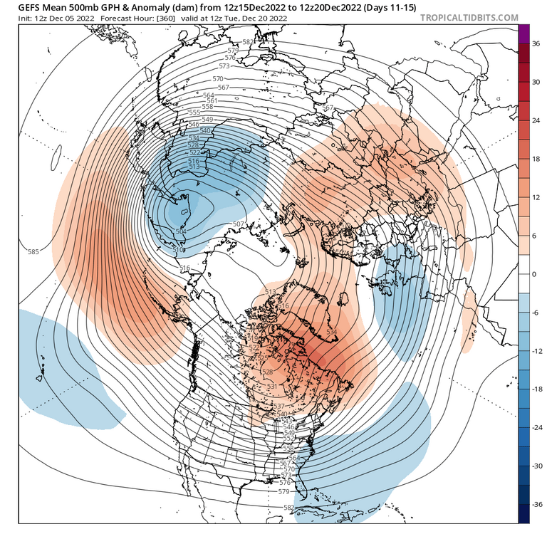
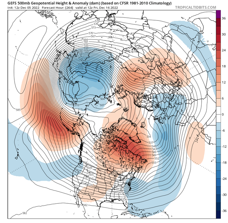
As @Weather Will shows there, 18z GEFS maintains more or less a similar look to 12z but more emphasizing the -EPO vs +PNA. All 3 ensemble systems have the -EPO in place by D8. D8 has more or less been our can kick point so that’s encouraging. Deeper into the runs they all get a cross-polar flow look as the EPO ridge goes across the AO domain. That will recharge Canada with very cold air if it happens eventually.
-
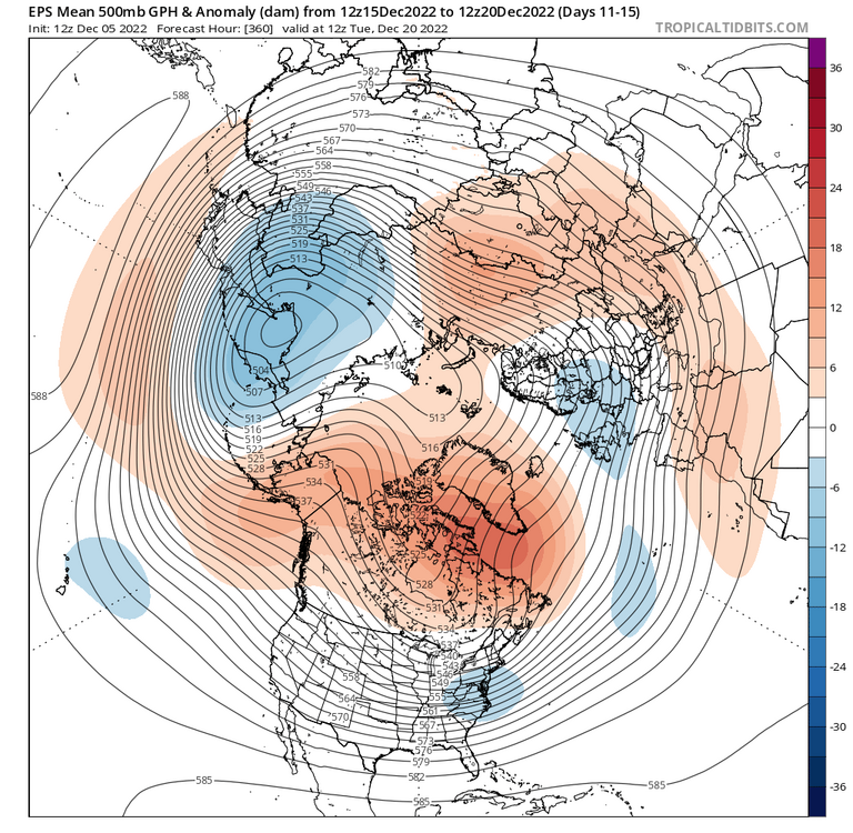
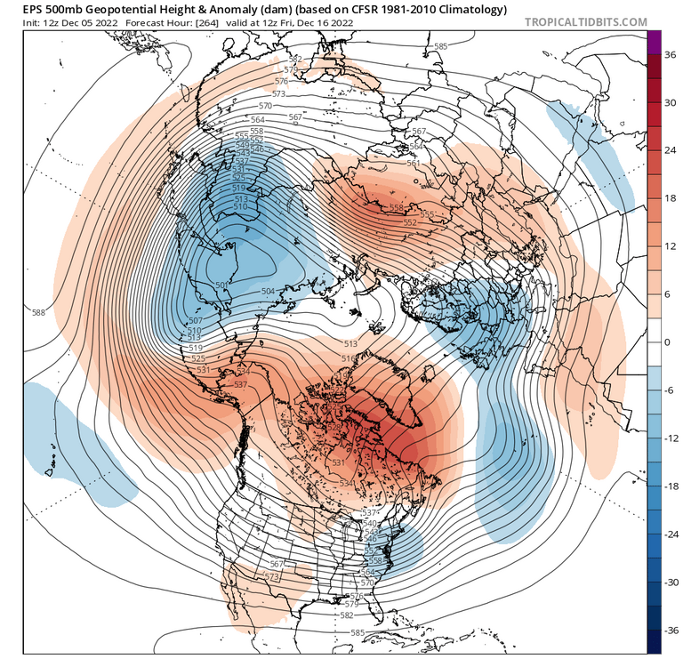
Maybe maybe not. The EPS pattern shown by @DarkSharkWX is “good” not “great”. More -EPO than +PNA and the ridging in the NAO is not a true block. But still a -AO. I’d certainly take it.
-
Lol you were saying?
-
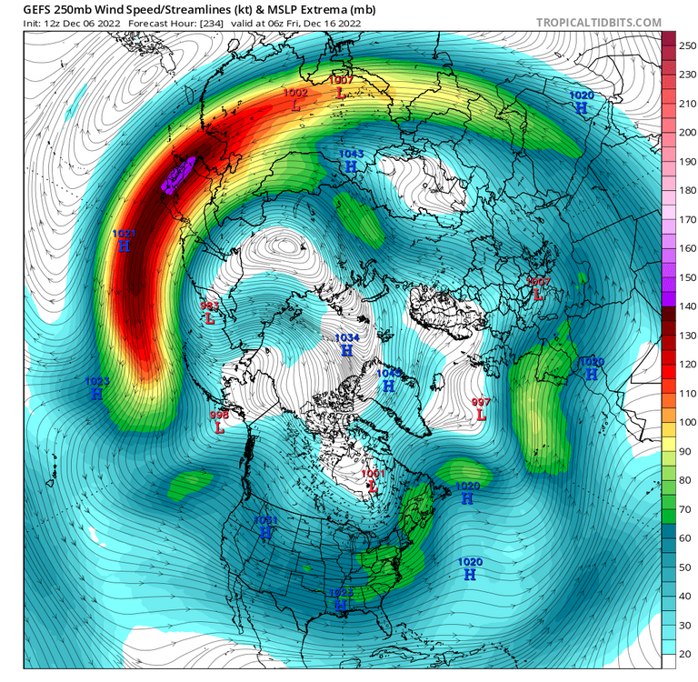
Wouldn’t shock me in the least Yes. GEFS still scours Canada free from most cold air, but that H5 look is light years better than it’s inverse. Yeah, I had to eyeball it as TT has no forecast trend plots for 250mb winds, but looked like a noticeable extension and strengthening after D7-8 on the 12z vs earlier runs.
-
Saw that! Bring it!
-
I’m on my phone so hard to post too many graphics but that forecast trend out west has totally flipped. It’s handling the Siberian PV a lot more like the eps. Seems to be all somewhat due to a much more extended Pac jet. Maybe due to an East Asian mountain torque event?
-
Lol just a few changes on the GEFS
-
^extrapolating a D13 KU there
-
These op GFS runs are just allergic to generating any legit cold air in North America and especially bringing any east of the Rockies. I miss the days of the always reliable D10+ blizzards.
-
Bingo
-
Follow up from above…if 1 runs trends are your thing (and we know they are!), 18z GEFS with more west coast ridging and moves the Siberian PV more into the Aleutians. Then it does it too much lol but one issue at a time .
-
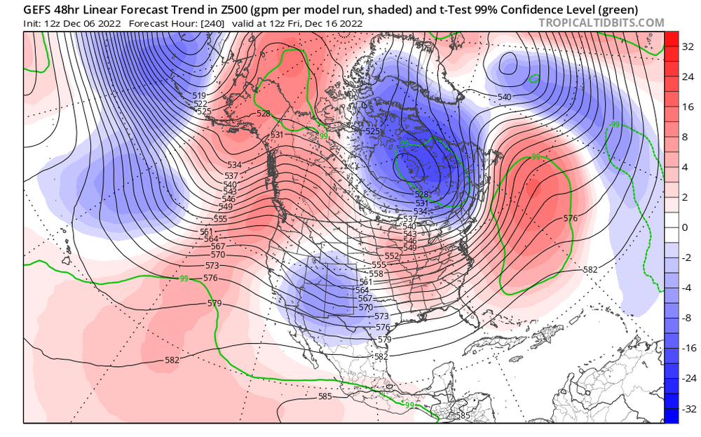
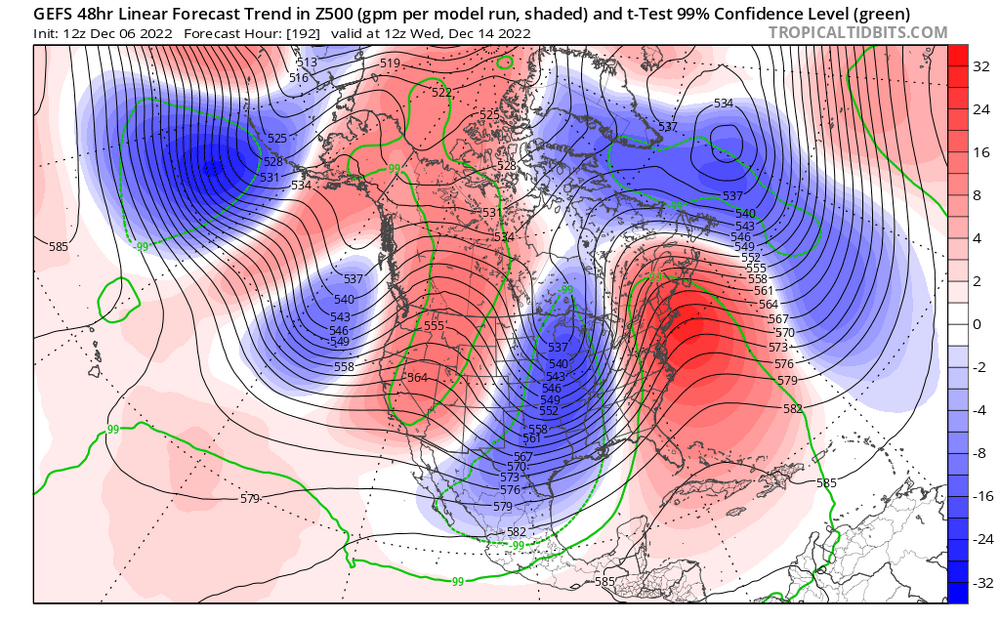
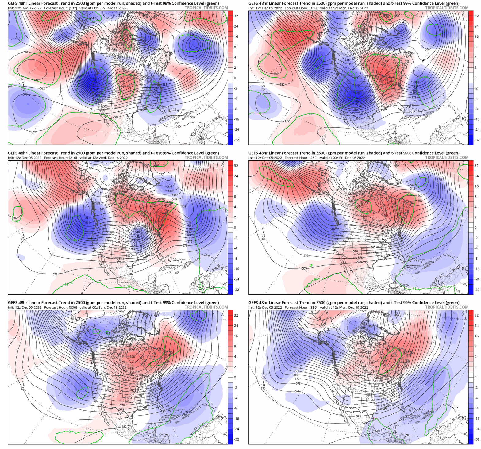
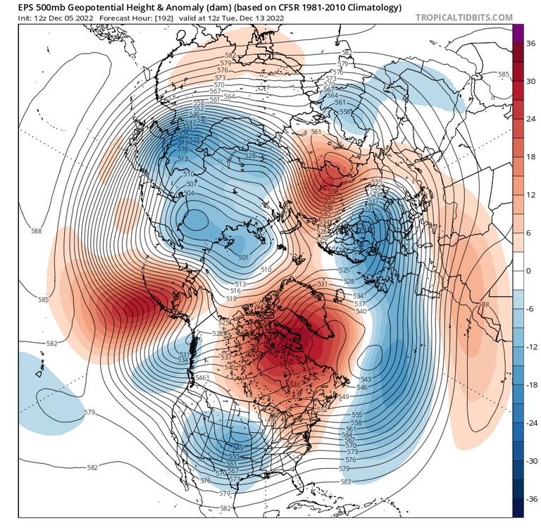
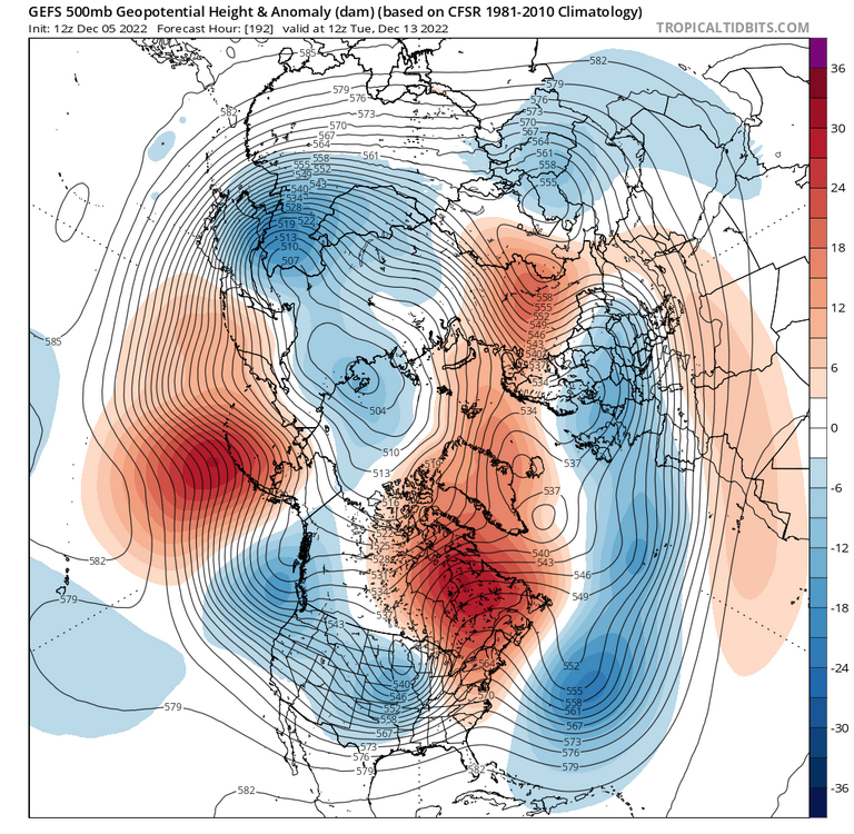
Ok, so is Lucy going to kick the football again? Today's EPS was run out of JB's basement. That's worth some private time alone in a dark room right there. -AO/-NAO/-EPO/+PNA Yahtzee! But will it actually happen? GEFS continues to be far less enthused about west coast ridging. And the GEFS has led the way with the current can kick. What continues to concern me is that GEFS, already with a less impressive Pacific sector than the EPS continues to correct to a stronger -PNA. Look at all this blue on the west coast in this gif. This is the GEFS forecast trend continuing to trend toward -PNA and/or more +EPO at all time steps as we march forward in time. Past performance is not necessarily an indicator for future performance though and there continue to be reasons to think that at.some.point the Pacific will improve enough to put us in the game. So what can we look at to distinguish between the EPS and GEFS solutions? I think the big tropospheric PV over Siberia/Sea of Okhotsk is a big discriminator. Below is the D8 depiction for both systems. There *should* be notable skill at D8 to forecast the location of such major features at H5. The EPS wants to push this farther east toward Kamchatka and the Aleutians, which eventually produces the pants tent depiction above as it continues eastward. GEFS lags it far behind and keeps it more over the Arctic Ocean and eastern Siberia. Blue over Kamchatka above, orange over it below. By D11, EPS has troughing extending into the Aleutians and we have a pretty El Niño type NHEM pattern. GEFS is following to some degree (notice the blue over Kamchatka now at D11), but still different enough to have some big sensible wx differences downstream for us. The EPS continuing to show an El Niño-like pattern in the midst of a La Niña and with the GEFS continuing to push more troughing into the West Coast are two things to give us some caution. I certainly hope it happens obviously! Got to watch how that Siberian PV moves and wobbles over the next few days.
-
Lol this Harbaugh quote: “a bad idea in the sense it had no chance”
-
Weeklies look good although I’m sure it’s missing the cutter that goes to Hudson Bay on the 23rd with 70F temps ahead of the front
-
@griteater with the festive report
-
^the Siberian/Okhotsk PV is key I think. I’ll make a longer post this evening about that after TT charts update.
-
It varies on the season and situation of course, but inside of 72hrs should have the H5 and surface depiction quite close to the final truth. Statistics clearly say the euro is the best at this, but it definitely gets schooled by other guidance more often than in the olden days.
-
@dtk
-
Euro is basically a hold for early Saturday. A bit weaker with the low and the cold push than 0z. Probably grassy accumulation for the N/W crew with maybe some white rain closer to the cities verbatim. There was a time that when the euro was locked in like this at D4-5 it was money, despite whatever other guidance. No longer…
-
Bengals are legit. Congrats in advance on the division as the ravens limp to a WC round blowout.
-
-
If it works out it’s very much a “just in time” cold air arrival with a little help from evaporative and dynamic cooling. That’s our wheelhouse!
-
Bengals beat the Chiefs. I can’t imagine the score if the ravens played the chiefs today, even with Lamar healthy.
-
I’ve done my 3rd last leaf cleanup. Probably 2 more last leaf cleanups to go


