WxUSAF
-
Posts
28,779 -
Joined
-
Last visited
Content Type
Profiles
Blogs
Forums
American Weather
Media Demo
Store
Gallery
Everything posted by WxUSAF
-
Euro caves to the gfs and turns Wednesday/thursday into a weak frontal passage.
-
Missed by a couple miles with the first round
-
Pennsylvania!
-
Giga-Nino is going to eventually crush the drought and wash away the barren ground of our yards after all the grass dies, dries up, and blows away in the next 3 months before the Nino kicks in.
-
But what to THE VIBEZ say about the rain??
-
O’s are demoralizing to watch
-
The typically drier spots on my lawn are already shockingly dry. I'm going to start watering tonight.
-
I count spring as March 1.
-
But we can actually measure and quantify this and see that’s not true?
-
My in-laws yesterday: “this has been one of the coldest springs!” Me: “actually it’s been one of the warmest springs so far, but yes, the last week has been cool.” Them: “I can’t remember wearing a sweater so much in spring though!” Me: “…” Frogs in the slowly heating pot…
-
Midweek rain fell apart overnight. Can’t break the drought. Yet…
-
Need all the help you can get watching the o’s… Moon is really beautiful rising right now. Full moon and looks sorta Halloween spooky.
-
I have a few mayapples! I have an area under some trees that I’m mostly leaving alone and intermittently planting some shade and dry soil tolerant natives. After 3-4 years, my Christmas ferns have started to spread. Dwarf crested iris has really spread and some asters have also spread into the shade a bit. There’s a lot of tree saplings and one sweetgum that volunteered is now like 6-7 feet tall. All that to say it can happen quicker than you might think if you don’t mow. I pull out any invasives that try to grow and any poison ivy (native but not welcome in my yard!).
-
It’s crazy how companies strip mine the topsoil of new developments to sell it off and leave the new homeowners with fill dirt and rocks. I’ll just generally encourage you to plant natives, and I’d be happy to offer suggestions if you want them! I was planting bushy St. John’s wort when I made that post. Have also added a new arrowwood, bluebells, blue mistflower, yarrow, and a “micropond” this year. HoCo and Columbia do lots of native plant giveaways every year so all of those were free.
-
Starting May in the 30s!
-
Just under 0.5” yesterday and about 2.4” for April.
-
Around 0.35” so far. Should be able to hit 0.5” with the second batch?
-
Just planted a few natives and boy is the soil dry despite rain the last 2 days.
-
About 1/4” so far. Up to about 0.7” for the “event” with yesterday
-
It won’t be immediate. But it will kick in eventually.
-
Giga-Nino cometh
-
Mini round 3 now
-

It's time to grade Winter 2025-26(now that it's actually over)
WxUSAF replied to CAPE's topic in Mid Atlantic
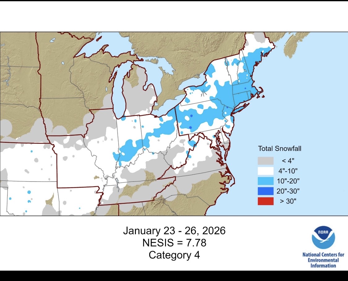
Jan 25 gets a Cat 4! Nice!
-
@Herb@MAWS, @Scraff, and I were winners. 0.3”+
-
Temp has dropped 20F with these showers. 61 now