WxUSAF
-
Posts
26,471 -
Joined
-
Last visited
Content Type
Profiles
Blogs
Forums
American Weather
Media Demo
Store
Gallery
Everything posted by WxUSAF
-
Low of 55. Happy fall!
-
If you believe the ensembles, the major heat does recede by next weekend and the week after. Still warm for September, but more like mid/upper 80s.
-
It looks awful. And probably will continue into at least the second week of the month, although maybe like upper 80s/low 90s vs near 100 next week. Might have to start looking at record warmest September and see how close we may get.
-
Nice rain for 5-10 minutes. Going to get crispy next week when @Jebman south Texas summer weather comes.
-
Dews in the 60s mostly. So could be worse I suppose, but HIs going to be in HA/EHW range almost certainly.
-
Next week is gonna SUCK
-
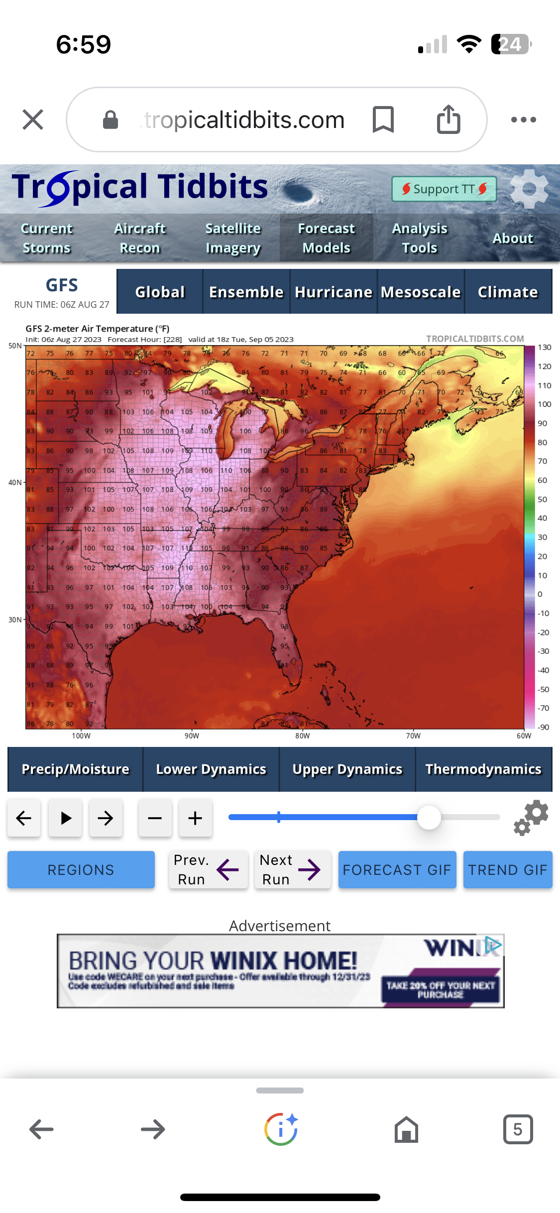
18z GFS says 8 consecutive 95F or higher days in September. Has that happened before?
-
12z gfs says we hit 110 the second week of September
-
Ok I’m done. I’ve hit my limit for hot temps. Under 80 at least please.
-
^thanks. Glad I wasn’t going crazy. It’s been putting out temps for next weekend and beyond that would probably challenge all time highs in the Plains and Midwest. In September… I don’t doubt it will be well AN, but it’s ridiculous.
-
I mean come on.
-
Well GFS thinks we’re gonna get stuck in the upper 90s and low 100s starting next Saturday
-
We’re doing our deep creek weekend early this year…Sep 22-25. I figure there should be some color but probably still 2-3 weeks before peak?
-
Yeah that’s some bad news to wake up to. Maybe best case is a shoulder strain or something like that? Hopefully not elbow/forearm…
-
Couple miles from home in SE Ellicott City and having a brief heavy rain shower. No thunder.
-
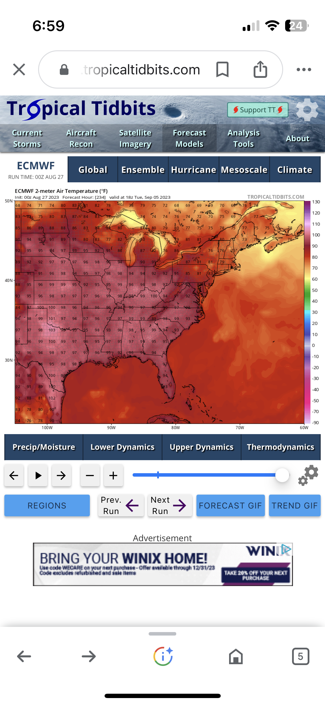
@dtk or someone else with knowledge…has the GFS changed their land surface model in some way? I know it’s been hot in many places, but the GFS has been putting out stupid crazy temps that are not verifying.
-
I was at the game and immediately jumped up and yelled TIE GAME BABY!!
-

2023 Mid-Atlantic Severe Wx Thread (General Discussion)
WxUSAF replied to Kmlwx's topic in Mid Atlantic
I’m gonna take the under on the mid 90s heat for today- 2,785 replies
-
- 1
-

-
- severe
- thunderstorms
- (and 3 more)
-
Euro has it also. Similar to GGEM through FL landfall, but euro gets shoved farther OTS with the incoming gorgeous early fall HP. Still probably cat 2/3 near our latitude though.
-
12z GGEM back with the eastern gulf homebrew that comes close enough to keep an eye on. Marginal PRE signal as well.
-
My prior for this winter is that there will be a lot of mild air around and probably a lot of precipitation. If we get a snowy winter, my assumption is that it will be with a solid/maybe epic 2-3 week period and if we’re really lucky we maybe get 2 of those periods. Obviously favoring Jan-Feb for cold and snowy periods.
-
Aleutian ridge with a strong Nino? Sure Jan.
-
Some rain (maybe 1”? Hard to tell because moisture gets pulled up ahead of a frontal boundary) and breezy
-
Up to 3-4” of rain on eastern shore. Maybe TS conditions for Ocean City.