WxUSAF
-
Posts
26,467 -
Joined
-
Last visited
Content Type
Profiles
Blogs
Forums
American Weather
Media Demo
Store
Gallery
Everything posted by WxUSAF
-
Yeah, maybe goes without saying, but for us east of the mountains in the mid-Atlantic to get snow in the post-thanksgiving period, something like that 6z gfs option is probably the best odds. Fresh cold airmass comes in and trailing wave is weak and moves along the thermal boundary to our south. A stronger storm would pull warmer air in and sink our chances east of the mountains. That’s more like 12z gfs next Saturday.
- 1,295 replies
-
- 4
-

-
- wishcasting
- almost winter
- (and 1 more)
-
I was just over 60” in 13-14 and I’m like <10 miles from BWI.
-
^still kinda crazy it’s even a bit FARTHER west than 2002/2009/1986. Despite our superdeeduper east based Nino. But I like descending motion over the maritime continent for sure.
- 1,295 replies
-
- 6
-
-
- wishcasting
- almost winter
- (and 1 more)
-
MJO progression into phases 3-4 (if it gets there) would suggest warmer risks going into December. That would also fit mod+ Nino climo. So we’ll see. But I think we get some sort of event in December.
- 1,295 replies
-
- 5
-
-
- wishcasting
- almost winter
- (and 1 more)
-
6z gfs agrees
- 1,295 replies
-
- 8
-
-
- wishcasting
- almost winter
- (and 1 more)
-
Ha jinx except I posted in banter
- 1,295 replies
-
- 1
-
-
- wishcasting
- almost winter
- (and 1 more)
-
Happy hour GFS saves winter before the turkey’s in the oven!!
-
I personally toss 91-92 entirely due to Pinatubo. And Pinatubo =\ Hunga Tonga. 57-58 seems to have a lot going for it as an analog. It was a well AN snowfall winter as well. I think even adjusting it for climate warming would suggest optimism for snow.
-
Wooo baby
-
Yeah EPS like the other ensembles are pretty cold after the midweek storm next week. Certainly upslope and lake effect will kick in at times. Doesn’t seem out of the realm of possibility to get some frozen precip east of the mountains if things shake out right.
- 1,295 replies
-
- 1
-
-
- wishcasting
- almost winter
- (and 1 more)
-
Canaan valley in 30-35” would maybe be their least snowy year on record? Lol
-
Snow stockholm syndrome
- 1,295 replies
-
- 3
-

-
- wishcasting
- almost winter
- (and 1 more)
-
12z GGEM is crazy cold for thanksgiving and would suggest snow flurries/showers verbatim especially for folks N/W and in the mountains.
- 1,295 replies
-
- 6
-
-
- wishcasting
- almost winter
- (and 1 more)
-
Great thread from @wxmvpete about next week. Winter could be saved!?!
- 1,295 replies
-
- 9
-
-

-
- wishcasting
- almost winter
- (and 1 more)
-
Another local TV met teams outlook that I think is supposed to message “above normal” snow (because this is, strictly, for DC alone) and ends up being slightly below normal to well below normal for most of the rest of the area.
-
Euro also with a chilly airmass next week. Friday’s rain chances do seem mostly dead unfortunately.
- 1,295 replies
-
- 1
-
-
- wishcasting
- almost winter
- (and 1 more)
-
Probably but not sure
-
I’m mostly a novice at this, but seems the -PDO numerical index is mostly driven by the very warm water off Japan, right? The SST map on our side of the dateline looks weakly +PDO to me with slight AN SSTs along the west coast and in the GoA.
-
Warm/cool/warm pattern in North Atlantic SSTs is allegedly correlated with -NAO
- 1,295 replies
-
- 2
-
-
- wishcasting
- almost winter
- (and 1 more)
-
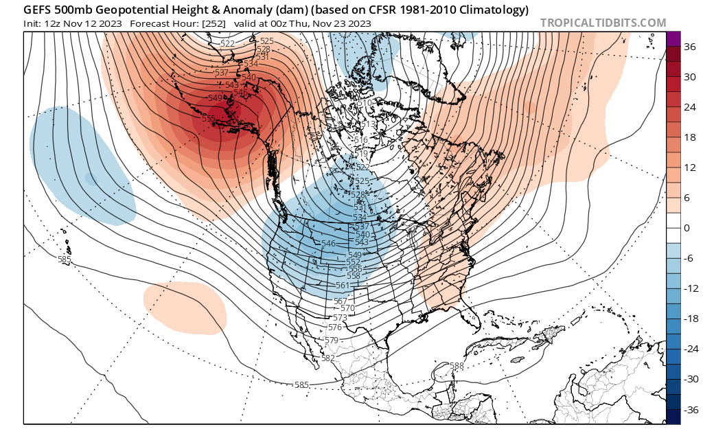
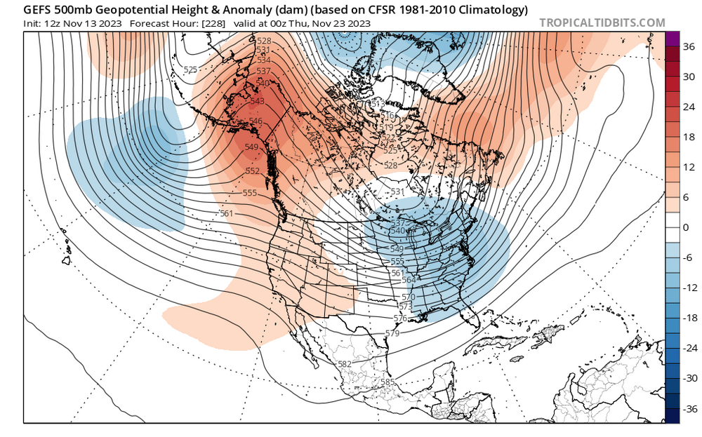
GEFS has flipped back once again to strong coupled +PNA/-EPO for Thanksgiving. The -EPO part has been quite consistent, but the pattern along the west coast has been flopping back and forth. Compare today and yesterdays 12z runs: GFS op and GGEM both have some very chilly airmasses for next week as well. Hopefully we can get the far N/W crew a slushy dusting out of this and save winter!

- 1,295 replies
-
- 16
-
-
-
-
- wishcasting
- almost winter
- (and 1 more)
-
The War on Unbridled Enthusiasm season starts earlier each year!
-
35 at DCA. Maybe a chance in a week?
-
28. Coldest of the season.
-
Nino^
- 1,295 replies
-
- 6
-
-
- wishcasting
- almost winter
- (and 1 more)
-
Sports are stupid