-
Posts
26,463 -
Joined
-
Last visited
Content Type
Profiles
Blogs
Forums
American Weather
Media Demo
Store
Gallery
Everything posted by WxUSAF
-
Actually December 1st is 12 days away…
- 1,295 replies
-
- 1
-

-
- wishcasting
- almost winter
-
(and 1 more)
Tagged with:
-
Picking the wrong side in The War on Thanksgiving smdh
-
Happy hour delivers love. And has lost a lot of the craziness it’s been showing the last 48 hours. Much more consistent with other guidance now.
- 1,295 replies
-
- 13
-

-
- wishcasting
- almost winter
-
(and 1 more)
Tagged with:
-
Yeah euro and GGEM have been showing some decent looking setups the week after thanksgiving for a day or two. Just hard to count it for much given how much the Tuesday-Saturday period is still in flux.
- 1,295 replies
-
- 7
-

-
- wishcasting
- almost winter
-
(and 1 more)
Tagged with:
-
-
- 1,295 replies
-
- 7
-

-
- wishcasting
- almost winter
-
(and 1 more)
Tagged with:
-
Me looking at D10 Euro…
- 1,295 replies
-
- 6
-

-
- wishcasting
- almost winter
-
(and 1 more)
Tagged with:
-
Sorry…if we don’t go from drought to flood status with feet of rain and highs in the 20s for thanksgiving then we might as well pack it up! And Ji and Chuck have already cancelled next winter. So see you in late 25??
- 1,295 replies
-
- 10
-

-
- wishcasting
- almost winter
-
(and 1 more)
Tagged with:
-
Notably the GEFS has not had these crazy swings like that last 2 runs of the GFS, although it certainly has tended to weaken the big Tuesday/Wednesday low pressure.
- 1,295 replies
-
- wishcasting
- almost winter
-
(and 1 more)
Tagged with:
-
GFS and GGEM both sort of split the big rainstorm into 2 systems and the cold air follows the second
- 1,295 replies
-
- wishcasting
- almost winter
-
(and 1 more)
Tagged with:
-
6z gfs/GEFS got some morning indigestion or something. Just slightly different for the holiday weekend.
- 1,295 replies
-
- 2
-

-
- wishcasting
- almost winter
-
(and 1 more)
Tagged with:
-
Someday I hope that every ravens win doesnt come with a cost of losing a key player for an extended period of time.
-
Maue just tweeted that things are coming back up, but I imagine it will be awhile before more products are flowing
-
Verbatim, 12z GGEM would threaten some record low maxes/record lows next Friday-Saturday. Especially for BWI and maybe IAD. But GGEM runs too cold at the surface…although I think gfs is too warm also. My wag right now is maybe 18-22 for lows at BWI and IAD and highs in the upper 30s?
- 1,295 replies
-
- 14
-

-
- wishcasting
- almost winter
-
(and 1 more)
Tagged with:
-
ECMWF had a major power outage earlier today. I’ve heard nothing since.
-
Can smell smoke in Columbia
-
0z Euro jumped on the cold/very cold holiday period. A lot of previous runs kept the coldest air well north even as GFS and GGEM brought the TPV south.
- 1,295 replies
-
- 7
-

-
- wishcasting
- almost winter
-
(and 1 more)
Tagged with:
-
Paging @Midlo Snow Maker
- 1,295 replies
-
- 3
-

-

-
- wishcasting
- almost winter
-
(and 1 more)
Tagged with:
-
How many inches of digital snow at your house count for inches of real snow in the Nov 20-Dec 10 window??
- 1,295 replies
-
- 7
-

-
- wishcasting
- almost winter
-
(and 1 more)
Tagged with:
-
If this was happening even a couple weeks later we’d be getting some major DT-type woofin’
- 1,295 replies
-
- 4
-

-
- wishcasting
- almost winter
-
(and 1 more)
Tagged with:
-
12z gfs actually fairly close to 6z considering it’s like D12
- 1,295 replies
-
- 1
-

-
- wishcasting
- almost winter
-
(and 1 more)
Tagged with:
-
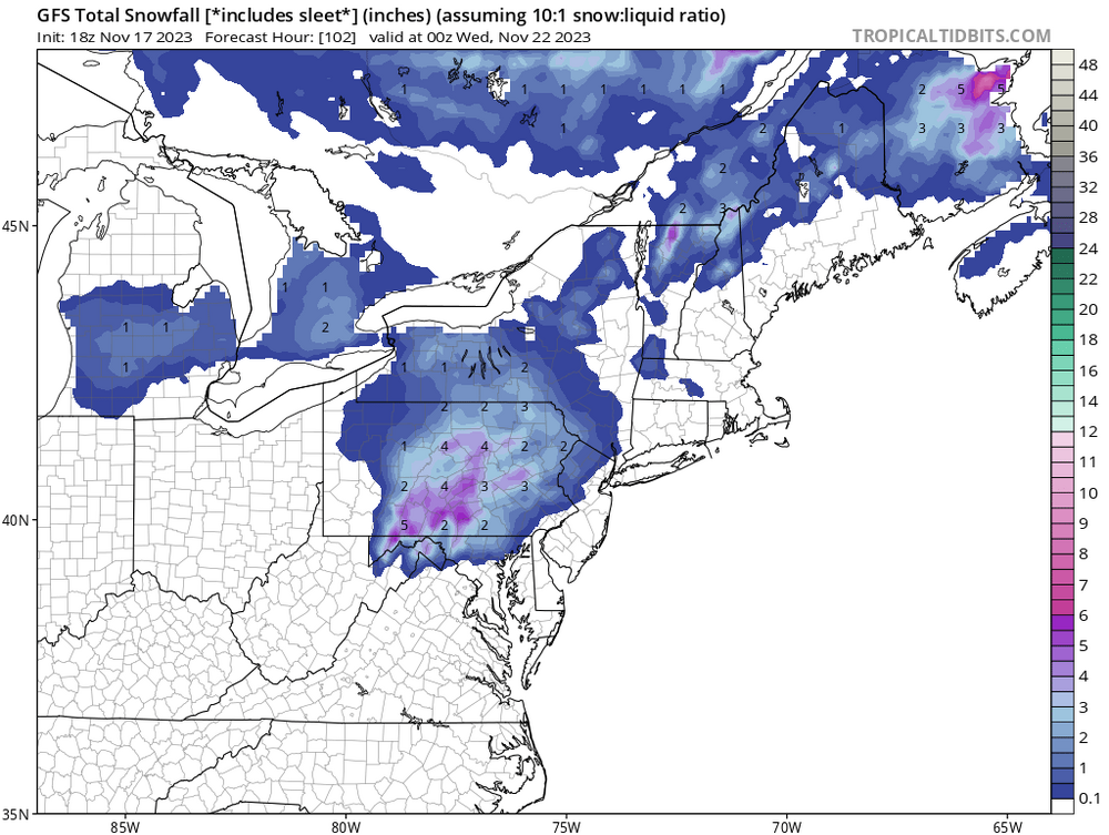
Yeah, maybe goes without saying, but for us east of the mountains in the mid-Atlantic to get snow in the post-thanksgiving period, something like that 6z gfs option is probably the best odds. Fresh cold airmass comes in and trailing wave is weak and moves along the thermal boundary to our south. A stronger storm would pull warmer air in and sink our chances east of the mountains. That’s more like 12z gfs next Saturday.
- 1,295 replies
-
- 4
-

-
- wishcasting
- almost winter
-
(and 1 more)
Tagged with:
-
I was just over 60” in 13-14 and I’m like <10 miles from BWI.
-
^still kinda crazy it’s even a bit FARTHER west than 2002/2009/1986. Despite our superdeeduper east based Nino. But I like descending motion over the maritime continent for sure.
- 1,295 replies
-
- 6
-

-
- wishcasting
- almost winter
-
(and 1 more)
Tagged with:
-
MJO progression into phases 3-4 (if it gets there) would suggest warmer risks going into December. That would also fit mod+ Nino climo. So we’ll see. But I think we get some sort of event in December.
- 1,295 replies
-
- 5
-

-
- wishcasting
- almost winter
-
(and 1 more)
Tagged with:


