-
Posts
26,463 -
Joined
-
Last visited
Content Type
Profiles
Blogs
Forums
American Weather
Media Demo
Store
Gallery
Everything posted by WxUSAF
-

Mid-Atlantic Snow Totals Thread - Winter 2023-2024
WxUSAF replied to mattie g's topic in Mid Atlantic
T: 12/6/2023 -
No, they’re not really. But the one thing that is common to our rain—>snow scenarios is a more Sw-NE oriented front vs very S-N orientation. Euro is getting that tilt more and hence the changeover.
-
Was like 6” at my house and I believe had some 10-12” reports S and E of DC. Had a strong gradient with the N and W folks getting actually fringed for once.
-
It definitely does happen? A lot of our storms start as rain. The early January 2022 event was deluge rain for 3-4 hours (temps were in the 50s and 60s day before?) and then switched to snow. It takes a certain set of conditions, but it can happen.
-
Euro ends the weekend rain storm as accumulating snow for N/W crew again.
-
I think we’re already seeing some “anti-cankicking” though. Next week has a notable +PNA now and GEFS and EPS have way reduced the amount of time with AN heights for our area.
-
Snow twice in the last week! #snowtown
-
Late next week is worth keeping an eye on, even if just because it’s all we have besides D15+ pattern watch. 12z and 18z gfs close. Ensembles don’t look enthused, but longwave pattern has been shifting more favorable for that time.
-
If you look at recent mod to super Ninos that didn’t give us a MECS or better, it’s mostly not because storms of that magnitude didn’t occur, it’s that they gave us rain or mixed precip. If you look at H5 and surface evolutions of 2-3 storms in 97-98, you’d get weak in the knees. Except it was 40F at the surface out past Hagerstown.
-
Don’t know about that, but odds of KU storms are certainly higher than normal this winter, particularly mid Jan-mid Feb.
-
Our hearts
-
I haven’t seen MJO charts in the last couple days, but I’d agree with @bluewave that it’s very likely the wave will go around the horn into 8-1-2. Doesn’t make sense for the wave to die as it’s getting to the best SSTs supporting convection.
-
Your mileage may vary
-
I’m certainly not calling it a L now. Just that game probably hurts them least to lose. Probably. Just not the Steelers please…
-
It’s at the very end of the EPS and GEFS, so obviously YMMV, but you can see the start of the process shown on the weeklies and GEFSX to get us a trough in the east. That’s what I will be watching this week.
-
#1 seed going to be tough. Probably still doable if they just lose to SF in the last 5 games?
-
Rejoice weenies, winter may be saved after all!
-
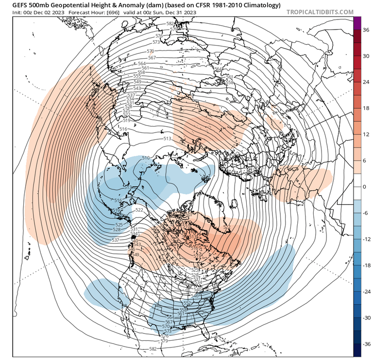
Although Will keeps us apprised of the euro weeklies every day, I hadn’t looked at the GEFS extended in awhile. Seems like a near carbon copy of the evolution shown by the euro. After mid-month, the west coast trough begins to retrograde, our eastern CONUS ridge begins getting undercut, and eventually we end up with pretty gorgeous pattern after Xmas.
-
Lock the end of happy hour dafuq in
-
That’s January thaw time. Maybe we can get a little something in February??
-
It’s December 2nd!!
-
Looking at @PrinceFrederickWx’s stats in the panic room makes me more dubious about some sort of early snow = snowy winter correlation. And even if there is a correlation, I’m dubious it’s indicative of the whole season. I just think in snowy years it snows more often and with heavier falls. And even that isn’t a super strong guide. This year probably isn’t going to be a 09-10 redux just because that was at least 1 in 150 year event, not because we had an inch December 5, 2009. A couple of the best analogs to this year had AN snowfall, but concentrated in a fairly epic 2-4 weeks. I still personally think we all get on the board this month at least once, but the bulk of the snow, no matter how much we get, is pretty sure to be in January and February (as it almost always is).
-
Still a chance for Hoffman to get his 1”!
-
Solar forcing going to be crappy for another few years. Might want to look forward to like 30-31.


