

John1122
-
Posts
10,682 -
Joined
-
Last visited
Content Type
Profiles
Blogs
Forums
American Weather
Media Demo
Store
Gallery
Everything posted by John1122
-
After Thursday rains, Friday rains and storms and some overnight rain, at 4.48 inches of rain for August. Normal is about 4.1 inches. Decent chances of rain today, tomorrow and tomorrow night as well. Model models are spitting out another 1-1.5 inches in my area from now til September 1st. I've had more than 6 inches of rain every month in 2019 so far. Will see if August can keep that up. My only near normal month was May and I average right at 6 inches in May though. Average is 4.05 in Sept and goes down to 3.3 in October. In November it heads back close to 6 inches on average.
- 117 replies
-
- 3
-

-
- grieving winter
- hoping for sunshine
- (and 2 more)
-
Spring/Summer 2019 medium to long range discussion.
John1122 replied to John1122's topic in Tennessee Valley
Had some rain again Thursday and big rains Friday that caused a 2 hour delay for the local HS football game from a thunderstorm that just crept across the area, it took those two hours for it to move 20 miles. Had additional showers over night and a rainy week is upcoming by the way things look. August is AN for precip here, as has every month of the year to date been AN except for May, which was right at normal. There's nothing remotely dry about lawns or anything else imby. Was talking to someone from Cocke County (that's who Campbell County played Friday night) and they said their yard was turning brown though and that they'd had hardly any rain since July. I am not really sure how or why SE Kentucky is in the drought monitor tbh, they have areas there in drought that were 5-8 inches AN for precip in June and 3-4 inches AN in July according to AHPS precipitation maps. It's not like they've gotten no rain in August either in those areas. -
Spring/Summer 2019 medium to long range discussion.
John1122 replied to John1122's topic in Tennessee Valley
If I remember correctly the only thing they had in common was the last massive severe thunderstorm that produced a major flash flood in the LaFollette area also happened that summer of 1993. It wasn't as wide spread as the big storm earlier this summer, but a smaller area got over 2 inches of rain in about 20 minutes in early July one evening. It put several city blocks under 3 or 4 feet of water. The big storm earlier this year was over a bigger area and had 6-8 inches of rain over a couple hours. It was notable in my mind for wind because it blew down a lot of trees here. Like 20-30 large oak trees. I got rain but not as heavy as LaFollette. It was just an extremely hot afternoon where a big storm popped up and got violent for that 20-30 minutes. It's the strongest wind event I've seen to this day. I'm certain it's just a coincidence though that two big pop up flooding storms happened that year and this one. The warm season weather pattern that year and this one are not at all similar here. That winter of 1993 was warm though. Until late February, we had 4 inches of snow the last few days of Feb 1993, then of course the blizzard two weeks later. -
Spring/Summer 2019 medium to long range discussion.
John1122 replied to John1122's topic in Tennessee Valley
Sumner of 1993 was very dry and very hot. July 1993 was over 90 all but 2 days of the month in Knoxville, with multiple days between 96-100, and those two days below 90 it was 89. Only rained about 2 inches in both June and July. -
Didn't end up nearly as hot today as predicted because it stormed around 11am. Had another round of very heavy rain this evening just before sunset. At 3.31 for August now. Which seems almost dry compared to most months this year.
- 117 replies
-
- 2
-
-
- grieving winter
- hoping for sunshine
- (and 2 more)
-
Noticed some big cells in Middle Valley areas. Heavy rain here right now but just a rumble or two of thunder every 4 or 5 minutes so far. Looks like Nashville is getting some flooding too. Looks like cells in Eastern Arkansas might reach West Tennessee. At least the heat may break there. The H.I in Memphis is 111 and 112 in Jackson with an 80 degree dp.
-
Spring/Summer 2019 medium to long range discussion.
John1122 replied to John1122's topic in Tennessee Valley
Figures the radar would be out and a severe threat would pop up. Also take it easy in West Tennessee, saw that the HI could close in on 120 in the Western Valley. -
Spring/Summer 2019 medium to long range discussion.
John1122 replied to John1122's topic in Tennessee Valley
I'm amazingly dry this month compared to the last few at only slightly above normal for the month to date so far. Take a look at this warm season -NAO stretch. Probably the longest negative summer stretch since 2012-2013. -
Had a few heavier showers this morning. Turned out to be a pretty nice but humid day today.
-
.91 yesterday, 2.31 through 4 days in August, looks dry for today with more rain returning soon.
-
Tennessee Valley 2019 Fall Speculation/Forecasting
John1122 replied to AMZ8990's topic in Tennessee Valley
We are in some form of tropical monsoon pattern and it's seemingly never going to end. I would welcome lower humidity but it seems like early fall has been hard to come by lately.- 574 replies
-
- 1
-
-
- early winter
- leaves changing
- (and 3 more)
-
Looks like the mid-state is getting some heavy rain out there too. Lots of thunder with mine earlier, which I always enjoy hearing, but the thunder moved out and now it's just moderate rain falling.
-
76.45 which was last year. It's currently pouring down right now as a complex of storms has fired on the NE Plateau.
- 117 replies
-
- 1
-
-
- grieving winter
- hoping for sunshine
- (and 2 more)
-
Had some windy storms this evening. Broke a power pole and knocked power out all over the mountain here. Picked up .74 inches of rain today and this evening. 1.38 after 2 days in August. If we can get any cold this winter and this precip pipeline continues maybe we can land some decent snows across the Valley region at some point this winter.
- 117 replies
-
- 3
-
-

-
- grieving winter
- hoping for sunshine
- (and 2 more)
-
The daily thunderstorm has fired up, we will see how much rain it drops.
- 117 replies
-
- 1
-
-
- grieving winter
- hoping for sunshine
- (and 2 more)
-
Ended July at 14.96 inches of rain for the month. It stormed a few minutes ago and earlier yesterday too, so at .64 already for August. Over 63 inches on the year imby.
- 117 replies
-
- 2
-
-
-
- grieving winter
- hoping for sunshine
- (and 2 more)
-
TN valley heavy rain/flooding week of whenever
John1122 replied to janetjanet998's topic in Tennessee Valley
Had another .55 so far today and a wall of heavy rain is about to move into the area. Flooding is breaking out in Scott and Morgan County and likely will here over the next few hours if that holds together. -
Had over 2 inches of rain in the last two days with 2-3 expected today and tonight. Already in double digits for July, looks like it will be another month in the mid teens for rain at this rate.
- 117 replies
-
- 2
-
-
-
- grieving winter
- hoping for sunshine
- (and 2 more)
-
It didn't rain yesterday, a rarity, but it looks like it's about to start now.
- 117 replies
-
- 1
-
-
- grieving winter
- hoping for sunshine
- (and 2 more)
-
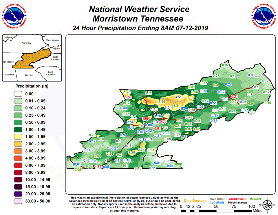
This is just from yesterday, it rained 1.5 inches on Wednesday. I'm at 9.14 inches for July already.
- 117 replies
-
- 1
-
-
- grieving winter
- hoping for sunshine
- (and 2 more)
-
Spring/Summer 2019 medium to long range discussion.
John1122 replied to John1122's topic in Tennessee Valley
There is a large Indiana bat cave near Jellico but I've never seen it affect a radar image before. -
I believe we've only had 2 or maybe 3 days without rain since June 25th here.
- 117 replies
-
- 1
-
-
- grieving winter
- hoping for sunshine
- (and 2 more)
-
2.88 inches of rain so far today with more coming. Flooding is widespread, had a rock slide on the interstate at mm 142. Tons of street and creek flooding in the area as well. Several roads are impassible. Some 5+ inch 24 hour rains showing up over Campbell and Claiborne.
- 117 replies
-
- 1
-
-
- grieving winter
- hoping for sunshine
- (and 2 more)
-
Getting blitzed again today with more flooding. It's been pouring for the better part 2 hours. Another 1.75 inches down today. Raining hard at the moment.
-
Pulled off 2 days without rain, but it just rained 1.5 inches in 45 minutes and caused more flooding in the area.
