John1122
-
Posts
10,682 -
Joined
-
Last visited
Content Type
Profiles
Blogs
Forums
American Weather
Media Demo
Store
Gallery
Everything posted by John1122
-
12/10-11/19 Potential Valley Wide Snow Event.
John1122 replied to John1122's topic in Tennessee Valley
In a small clearing but looks like 1-2 enhanced bands still to come for my area.
- 486 replies
-
- 1
-

-
- snow
- rain to snow
- (and 2 more)
-
12/10-11/19 Potential Valley Wide Snow Event.
John1122 replied to John1122's topic in Tennessee Valley
Have hit 4 inches now on car tops. Probably 3 on the ground.- 486 replies
-
- 4
-

-
-
- snow
- rain to snow
- (and 2 more)
-
12/10-11/19 Potential Valley Wide Snow Event.
John1122 replied to John1122's topic in Tennessee Valley
Blind hog and acorns. Looks like the Canadian/GFS suite is going to be right for our area.- 486 replies
-
- 2
-

-
-
- snow
- rain to snow
- (and 2 more)
-
12/10-11/19 Potential Valley Wide Snow Event.
John1122 replied to John1122's topic in Tennessee Valley
That's tough. I figured you'd do okay. It apparently oriented just south of you.- 486 replies
-
- 1
-
-
- snow
- rain to snow
- (and 2 more)
-
12/10-11/19 Potential Valley Wide Snow Event.
John1122 replied to John1122's topic in Tennessee Valley
I went into the local mexican restaurant at 7:05. My front and back windows clear and the main highway was snow free. I came out at 7:35 and there was 3/4ths inch of snow on my front and back window and the main highway is now snow covered. It's been coming down very heavily.- 486 replies
-
- 4
-
-
-
- snow
- rain to snow
- (and 2 more)
-
12/10-11/19 Potential Valley Wide Snow Event.
John1122 replied to John1122's topic in Tennessee Valley
Roads are a mess here if not on the heavily salted areas. As I spoke about this morning, after dark + below freezing + snow rate = bad roads even if it was 55 yesterday. Big miss by MRX given that they were confident of advisory level totals.- 486 replies
-
- 2
-
-
- snow
- rain to snow
- (and 2 more)
-
12/10-11/19 Potential Valley Wide Snow Event.
John1122 replied to John1122's topic in Tennessee Valley
Keep feeding it my way!- 486 replies
-
- 2
-
-
- snow
- rain to snow
- (and 2 more)
-
12/10-11/19 Potential Valley Wide Snow Event.
John1122 replied to John1122's topic in Tennessee Valley
The flakes are smaller now with the temp well below freezing. The rate is heavier through. Visibility is about 1/4th mile and it's also windy at times. Mini Blizzard!- 486 replies
-
- 2
-

-
-
- snow
- rain to snow
- (and 2 more)
-
12/10-11/19 Potential Valley Wide Snow Event.
John1122 replied to John1122's topic in Tennessee Valley
I keep looking out expecting a let up, but it doesn't let up. 2.75 inches and climbing fast. If it snows until midnight I feel like I'll get 4-5 inches. If it snows like this until midnight I'll get 6.- 486 replies
-
- 2
-
-
- snow
- rain to snow
- (and 2 more)
-
12/10-11/19 Potential Valley Wide Snow Event.
John1122 replied to John1122's topic in Tennessee Valley
Looking at radar returns in Western Cumberland, I figured you'd have 3 inches or more.- 486 replies
-
- 1
-
-
- snow
- rain to snow
- (and 2 more)
-
12/10-11/19 Potential Valley Wide Snow Event.
John1122 replied to John1122's topic in Tennessee Valley
Crossed 2 inches. Snow globe still in effect.- 486 replies
-
- 3
-
-
-
- snow
- rain to snow
- (and 2 more)
-
12/10-11/19 Potential Valley Wide Snow Event.
John1122 replied to John1122's topic in Tennessee Valley
Very happy for you!- 486 replies
-
- 2
-
-
-
- snow
- rain to snow
- (and 2 more)
-
12/10-11/19 Potential Valley Wide Snow Event.
John1122 replied to John1122's topic in Tennessee Valley
Same here. It's just blitzing down half dollar sized flakes.- 486 replies
-
- 2
-
-
- snow
- rain to snow
- (and 2 more)
-
12/10-11/19 Potential Valley Wide Snow Event.
John1122 replied to John1122's topic in Tennessee Valley
1.5 inches down. About 1/4 inch in the last 10 minutes, very heavy snow.- 486 replies
-
- 2
-
-
- snow
- rain to snow
- (and 2 more)
-
12/10-11/19 Potential Valley Wide Snow Event.
John1122 replied to John1122's topic in Tennessee Valley
It's like a snowglobe outside here right now. Huge flakes filling the air.- 486 replies
-
- 4
-
-
- snow
- rain to snow
- (and 2 more)
-
12/10-11/19 Potential Valley Wide Snow Event.
John1122 replied to John1122's topic in Tennessee Valley
There's an impressive moisture flow all the way from Louisiana streaming NE ward. Not sure how long it will last, but this is basically what the GFS kept seeing that was laying down 2-4 inches. Not sure if the GFS was taking into account dry air causing virga.- 486 replies
-
- 4
-
-
-
- snow
- rain to snow
- (and 2 more)
-
12/10-11/19 Potential Valley Wide Snow Event.
John1122 replied to John1122's topic in Tennessee Valley
Snowing very hard again. The band looks to have about another hour to go here.- 486 replies
-
- 1
-
-
- snow
- rain to snow
- (and 2 more)
-
12/10-11/19 Potential Valley Wide Snow Event.
John1122 replied to John1122's topic in Tennessee Valley
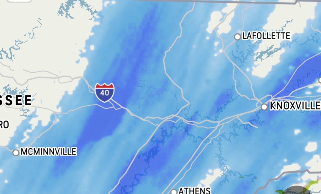
Looks like an area of very heavy stuff should fill over you shortly. It's showing up with some 35dbz reflections over western Cumberland and is filling in eastwards.- 486 replies
-
- 3
-
-
- snow
- rain to snow
- (and 2 more)
-
12/10-11/19 Potential Valley Wide Snow Event.
John1122 replied to John1122's topic in Tennessee Valley
Slacked off here but another wave of very heavy stuff is working it's way NE up the Plateau again.- 486 replies
-
- 1
-
-
- snow
- rain to snow
- (and 2 more)
-
12/10-11/19 Potential Valley Wide Snow Event.
John1122 replied to John1122's topic in Tennessee Valley
They used to work out often, last major one I had before this year was probably 2009.- 486 replies
-
- 1
-
-
- snow
- rain to snow
- (and 2 more)
-
12/10-11/19 Potential Valley Wide Snow Event.
John1122 replied to John1122's topic in Tennessee Valley
It's snowing as far back as Tupelo. Snowing in Huntsville. So a decent area of upstream moisture. This is an old school rain to snow event.- 486 replies
-
- 3
-
-
- snow
- rain to snow
- (and 2 more)
-
12/10-11/19 Potential Valley Wide Snow Event.
John1122 replied to John1122's topic in Tennessee Valley
With the orientation of the precip, you're very close to being directly upstream from me. -
12/10-11/19 Potential Valley Wide Snow Event.
John1122 replied to John1122's topic in Tennessee Valley
3/4ths inch down. Side roads starting to see white spots. 29 degrees.- 486 replies
-
- 1
-
-
- snow
- rain to snow
- (and 2 more)
-
12/10-11/19 Potential Valley Wide Snow Event.
John1122 replied to John1122's topic in Tennessee Valley
Not sure what the ground reality is in the Nashville area but the radar actually keeps enhancing there. -
12/10-11/19 Potential Valley Wide Snow Event.
John1122 replied to John1122's topic in Tennessee Valley
1/2 inch down. Snowing moderately. The early change over models nailed it pretty well, not sure what MRX used to populate their point forecast but they maybe should abandon it.- 486 replies
-
- 4
-
-
-
- snow
- rain to snow
- (and 2 more)